Parks in the central city

Winn Park

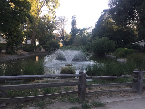
Winn Park, a block-square park between P & Q, and 27th & 28th, seems dead to me. It doesn’t matter what time of day I see the park, it is almost always empty, sometimes with some homeless folks hanging out, and more rarely, a family with kids on the playground equipment. Other parks seem lively much of the day. Why are the parks so different? I have been visiting all the parks in Sacramento central city to take photos and see if I can make sense of their characteristics.

Read More »

big smiles at Sunday Street on Broadway

Sacramento’s first open street event* took place on Sunday, Sunday Street on Broadway.  

Broadway was closed to cars and open to people from 8 to noon. The route was on Broadway from Riverside east to 26th St, jogged down to 2nd Ave, and then ended again at Broadway. People were wondering how this would work in Sacramento, the first time, and in a place that is pretty car-centric. Well it worked great! A lot of people came out. I’m sure the city will have an estimate, but the initial answer is, a lot.

If success is measured by smiles, and it should be, this event was a great success. People of all ages were there, people from the neighborhood and the region. A lot of people were bicycling, but a lot were walking, and using other wheeled devices. Slide tricycles, which I didn’t even realize were a thing in Sacramento, were common.

Sacramento Area Bicycle Advocates (SABA) created a separated bikeway (protected bike lane) for people to experience, which attracted a lot of attention and generated a lot of discussion about the state of bicycling in Sacramento. Adjacent, WALKSacramento asked people to add their favorite places to walk to a chalk board, all of which were NOT car-dominated places. Some people prioritized how it felt to walk, others their destination. Ice cream was a popular theme. 

Outside food vendors were prohibited in order to highlight local restaurants. For those open, business was booming. Some places missed out, though, by not being open. I’d imagine as word gets around how well it works, food retail along future events will be open and prosperous. Many business owners just assume that most of their customers come by car, but places that encourage and activate walking and bicycling all have increased business. Vintage Bicycle Supply was open and crowded with people not even aware it existed, and fans of the CycleFest cruiser bikes. New Helvetia Brewing was quenching people’s thirst and hosting running clubs. There were a lot of sports and fitness vendors, showing people what they had to offer and just providing fun. The two hula hoop groups were particularly popular with kids, and there were chalk drawings everywhere. Sidewalk chalk may be the single most important tool available to the public for activating public spaces. 

SACOG and Social Bicycles were showing off the new bike share which opened just Thursday. I heard comments from a lot of people that they found the bikes easier to ride than they thought, and were looking forward to trying it out. [previous post riding the bike share.

The section along 26th St and 2nd Ave was much quieter, with a cluster of local businesses and organizations near the end at Broadway. It was also far cooler than Broadway, with all the street trees moderating the temperature about 10 degrees below Broadway. This was not only much appreciated by people, but points out that for the new Broadway to work for pedestrians and bicyclists, it is going to need to not only not lose many of the existing trees, but to really create a welcoming tree lined street. When I participated in the public meetings the last two years, I didn’t realize how important street trees would be. Since Broadway will be a vibrant commercial corridor, it may be that the big shade trees should be in the median, with less dense trees between the street and retail, so that the view of customers is not obstructed. Interesting design issues. 

Hope you had a fun time too! I’m looking forward to the next one. 

Photos on Flickr

* Though the county claims its Great Scott road closure is an open street event, it really does not meet the widely accepted definition of an open street.

transportation development impact fee

The City of Sacramento is working on a Transportation Development Impact Fee (TDIF) for the entire city, and with somewhat different requirements for subareas including downtown, river district, and North Natomas. The Sacramento Bee clued me into the proposal with Sacramento asks developers to open wallets to keep city streets from clogging (SacBee 2016-12-08). My initial guess was that this is in response to the failure of Measure B, but this proposal has been worked on since at least August, so that is not the case. The city has a webpage on development impact fees, with two documents specifically about the transportation DIF. I have not had the time to delve into the details, nor do I have any expertise in this area, so these are my initial thoughts.

Read More »

city failure on Capitol Mall bike lane

Sacramento has nearly completed a reconstructed bridge over I-5 between 3rd Street and Tower Bridge. This is part of a project to provide access from and to Old Sacramento, but that part is not complete yet. The pavement is fresh, with bright white lines and green carpet bike lanes. But, the bike lane design is a failure. The eastbound bike lane is OK. A little strange because it varies in width, but acceptable. The westbound bike lane, though, is a hazard to bicyclists.

Below is a photo of the first problem, a bike lane to the right of a place where a right turn is permitted. This is at the entrance to the Old Sacramento access.The straight-and-right arrow indicates that the city expects heavy right turning traffic at this location.

While this design is in compliance with the law, using a dashed line to indicate that traffic from the general purpose lane and the bike lane should safely merge, the use of green paint here is the wrong message. Though green paint has no legal meaning, the general meaning taken is that this is the place for bicycles. So an average bicyclist will stay in the bike lane, not realizing that the safe manesuver is to merge into the general purpose lane. The result is a right hook danger that has been created by the design.

IMG_0769
Stay to the right of right turning cars? NO!

There are a lot of ways to solve this issue, but this is the worst possible solution. Creating a separate signal phase for bicyclists and right turning traffic is one solution. Dropping the bike lane in favor of green-back sharrows in the general purpose lane is another.

However, this problem spot is minor in comparison to what happens just on the other side of the intersection. Here, the bike lane suddenly ends and becomes a right turn only lane. There is no signing for bicyclists or motor vehicle drivers, no pavement markings, no indication of what biyclists should do. I’m a vehicular bicyclist and would not be in this bike lane fragment to begin with, but for the average bicyclist, this green paint is a clear message, “this is where you belong.” Whoops. Sorry. Turns out we needed the road for a right turn lane, and just got rid of the bike lane. Hope you are still alive, but if not, well it wasn’t our fault. But the thing is, it is the city’s fault. This is a mis-design, and the city should be sued the first time someone is injured at this location. It is not as though this was an existing location where the city did the best if could to squeeze in bike facilities. This is a new construction where things should have been done right. They were not.

IMG_0771.JPG
Bike lane ends suddenly – good luck!

There are several good solutions for this location, and the NACTO Guide to Urban Bicycling has several, but even the standard MUTCD design is better than this. Though you can’t see the turn lane due to the parked FedEx van (it was there for more than 10 minutes, double-parked, and I couldn’t wait any longer for the photo), there are no bike markings in the right turn lane at all. There is no “bicyclists may use full lane” sign. Maybe bicyclists are meant to fly over this right turn lane and return to earth at the bridge. Or maybe they are meant to die.

As I always warn people in bicyclist education classes, don’t get sucked in by paint. Paint doesn’t keep you safe. And in this particular case, paint creates a danger for you that would not exist if not for the paint. Negligent design, for sure.

So, what is SacBAC?

When talking to people about local transportation issues, the subject of SacBAC comes up, and at least half the people say “SacBAC? What is that?” SacBAC is the Sacramento Bicycle Advisory Committee. It is a joint committee formed by the City of Sacramento and the County of Sacramento to advise the respective governments on bicycle issues. It was officially chartered in 1995, and has twelve members, six appointed by the city council and six appointed by the county board of supervisors. It is supported by two staff, the City of Sacramento Bike and Pedestrian Coordinator, Ed Cox, and the County of Sacramento Alternative Modes Coordinator, Dan Klinker. The committee meets once a month, on the second Tuesday, 6:00-8:00PM, in room 1217 of Sacramento City Hall at 915 I Street. The meetings are open to the public.

The agenda for the August 11 meeting is available.

Read More »

bicyclist collisions in Sacramento

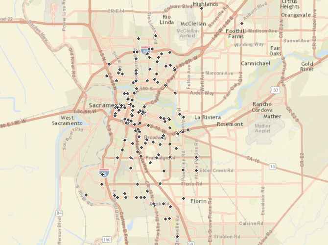
This post complements my recent post on pedestrian collisions in Sacramento. Please see that post for details about data sources (SWITRS GIS Map in TIMS) and mapping.

The collisions mapped are:

  • Date: 01-01-2004 to 12-31-2012
  • Location: City of Sacramento only (no, I can’t explain why some are outside the city)
  • Victim role: Bicyclist
  • Victim degree of injury: Killed or Severe Injury
  • 143 collisions (the pedestrian collisions were 388)

The overall number of bicyclist collisions in the killed or severe injury category over this nine year period is low enough that patterns may not accurately represent hazardous roadways since a small number of collisions can significantly change the pattern.

The first map, a point map of the entire city, shows:

  • the greatest density of collisions is in downtown/midtown, but there are certainly plenty in other areas
  • almost all collisions happen at intersections, not mid-block
  • almost all collisions are associated with major streets, called arterials and collectors, which are wide and high speed, intended to move motor vehicle traffic at speed rather than provide for multi-modal transportation

bicyclist collisions, City of Sacramento, killed or severe injury

Read More »

pedestrian collisions in Sacramento

I often wonder if governments really focus on the issues rather than responding to incidents. In the case of pedestrians and the City of Sacramento, is the city really placing its attention, and its dollars, where they need to be to enhance the safety of pedestrians? I’ve created some maps to show where the problems lie (see note at bottom about data sources and how these were created).

The collisions mapped are:

  • Date: 01-01-2004 to 12-31-2012
  • Location: City of Sacramento only (no, I can’t explain why some are outside the city)
  • Victim role: Pedestrian
  • Victim degree of injury: Killed or Severe Injury
  • 388 collisions
  • ArcGIS link

The first map, a point map of the entire city, shows:

  • the greatest density of collisions is in downtown/midtown, but there are certainly plenty in other areas
  • almost all collisions happen at intersections, not mid-block
  • almost all collisions are associated with major streets, called arterials and collectors, which are wide and high speed, intended to move motor vehicle traffic at speed rather than provide for multi-modal transportation

pedestrian collisions, killed or severe injury
pedestrian collisions, killed or severe injury, point map

Read More »

parking fees

The Sacramento News & Review published this week Parking Nightmare: Major changes in Sacramento could mean higher prices, stiffer restrictions, following up on a earlier blog post  (https://www.newsreview.com/sacramento/pageburner/blogs, scroll down to July 15). SacBee also had an article on Friday, Downtown Sacramento parking rates likely to rise. Apart from the SN&R click-bait headline, the article provides more depth than anything else available at the moment, and provides me a chance to review parking fees and consequences. First, I would not for a moment counter the claim that an increase in parking charges is due at least in part to the city’s need to increase revenue to pay off arena bonds. But beyond that, it is possible to evaluate how parking should be priced.

My views on parking are all based on two concepts:

  • TheHighCostOfFreeParking_coverThere is no such thing as free parking. If parking is free, it is being subsidized by someone. The seminal thinking on this issue is The High Cost of Free Parking, by Donald Shoup, as well as writings by others. The objective of managed parking pricing should be to ensure some free parking on every block so that people do not circle looking for parking, and that some of the parking fee income be returned to the neighborhood for improving the right-of-way, including sidewalks and pedestrian amenities.
  • On-street parking is not, as some people think, a bad thing. It slows traffic by generating “friction.” On street parking might be removed when there is clearly a higher use for road right-of-way, such as bike lanes or sidewalks, however, in almost all cases, removal of a travel lane is better for everyone than removal of on-street parking. I don’t support on-street parking because I want to see more space devoted to motor vehicles, but because of the traffic calming effect and because I think on-street parking creates a more livable environment than do parking garages, which I consider to be the lowest use (or mis-use) of urban land, only exceeded by off-street surface parking lots. Our streets would in fact be safer if there were more on-street parking on weekends and evenings, when most of the extremely dangerous  and egregious speeding occurs.

Read More »

Grid 2.0 pedestrian comments

The City of Sacramento Grid 2.0 project is requesting specific input on ways to improve the pedestrian experience in midtown/downtown. I encourage you to go there and add your pins.

Pedestrian beg button on a commonly used crosswalk, this location should have a pedestrian signal on every cycle, not just when someone presses the button.
Pedestrian beg button on a commonly used crosswalk (K & 9th), this location should have a pedestrian signal on every cycle, not just when someone presses the button.

Dropping pins on a map, however, doesn’t allow some more general comments that I think are very important, and perhaps just as important as any of the corridor improvements shown. For me, these points are:

  1. All signals and pedestrian signals in the grid should be set on automatic recall by default. That means that pedestrians get a walk signal on every cycle without having to find and press the beg button (many of which can’t be accessed by disabled people). If the city thinks that a particular crossing should require a button, they should have to do a traffic study to justify it, which includes both the requirements that 1) the level of pedestrian use if very low (unlikely in the grid, but possible), and 2) that there is a demonstrable delay in traffic due to automatic recall. This does not mean that pedestrian buttons will not be present, as there may be valid ADA benefits to having them, including the specific announcements now being included, but they should never be required.
  2. In heavy pedestrian use area, if pedestrian buttons are present, pressing the button should actually shorten the signal cycle to provide for pedestrian crossing on demand, rather than just changing the pedestrian signal head when the signal goes through its regular slow cycle. No regular cycle should be longer than 90 seconds because long cycles unnecessarily delay pedestrian (and bicyclist) travel in favor of motor vehicle traffic.
  3. All three-lane one-way roads should be reduced to two lanes. This will make street crossings safer (by about 1/3 – what other improvement could make such a difference!) and more comfortable. There is no excuse in a walkable urban environment for there to be three-lane one-way streets.
  4. All no-pedestrian-crossing locations should be removed and replaced with regular high visibility crosswalks. Though these prohibitions are often justified by safety concerns, they are really just for the convenience of motor vehicle drivers, so that they don’t have to slow down or wait as long at signals. If a crosswalk is not safe, it means the roadway design is unsafe, and the correct solution is to change the roadway design, not to prohibit crossing.
  5. The ability to safely and comfortably cross streets is just as important to people walking as the ability to walk along streets. I don’t know that this is the case here, but transportation agencies often get so focused on travel along corridors that they forget about the need to cross corridors. The grid pattern in midtown/downtown eases this problem, and is in fact one of the major benefits to a grid, but nevertheless, significant attention must be paid to crossing.

streetcar vote coming

I live within the influence/taxation zone for the proposed Sacramento Streetcar, Sacramento Measure B, so I received a voter information pamphlet, and presumably will receive a ballot within a few days. Let me say right up front that I am voting yes. I support the streetcar for its economic and transportation benefits. However, I’d like to address some of the anti arguments.

YesOnB

No on Measure B

The pro side is well represented at http://gosacstreetcar.com, and the other websites linked from there. I have not found a website for the anti side, but their arguments are in the information packet and on the sign above.

Here are the anti arguments, from the pamphlet, with my comments in green:

Read More »