The City of Sacramento charges fees for it’s ‘Al Fresco’ dining program, where restaurants may apply for an encroachment permit, and an ongoing revocable permit in order to provide a dining area within re-purposed parking spots. The city used to have hundreds of these setups, and during the early days of the pandemic, several streets were closed completely so that restaurants could offer outside safe dining. The number of such setups has shrunk considerably. Many businesses did not find it worthwhile to go through the process, and the expense. The city established strict criteria, that some locations could not or did not want to meet. They ‘grandfathered in’ existing sidewalk dining, for a while, but those locations must transition to the new program, which was established in 2023.
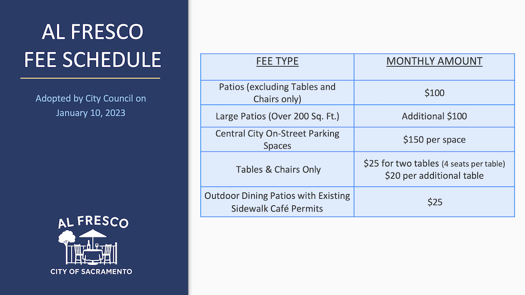
Al Fresco dining often removes sidewalk buffers and street parking. As such, the city charges, for use of the space (though the city does not maintain sidewalk buffers, it does own them) and loss of parking revenue. Though the fees are not posted anywhere on the city website, a presentation to city council on October 14, 2025, provides the fee structure for fees adopted in January 2023. So far as is known, the fees have not changed. (Note that this does not include the encroachment permit fee, a one-time fee.) pdf of the entire SacCouncil presentation
SacCouncil 2025-10-14 presentation on Al Fresco program, page 14
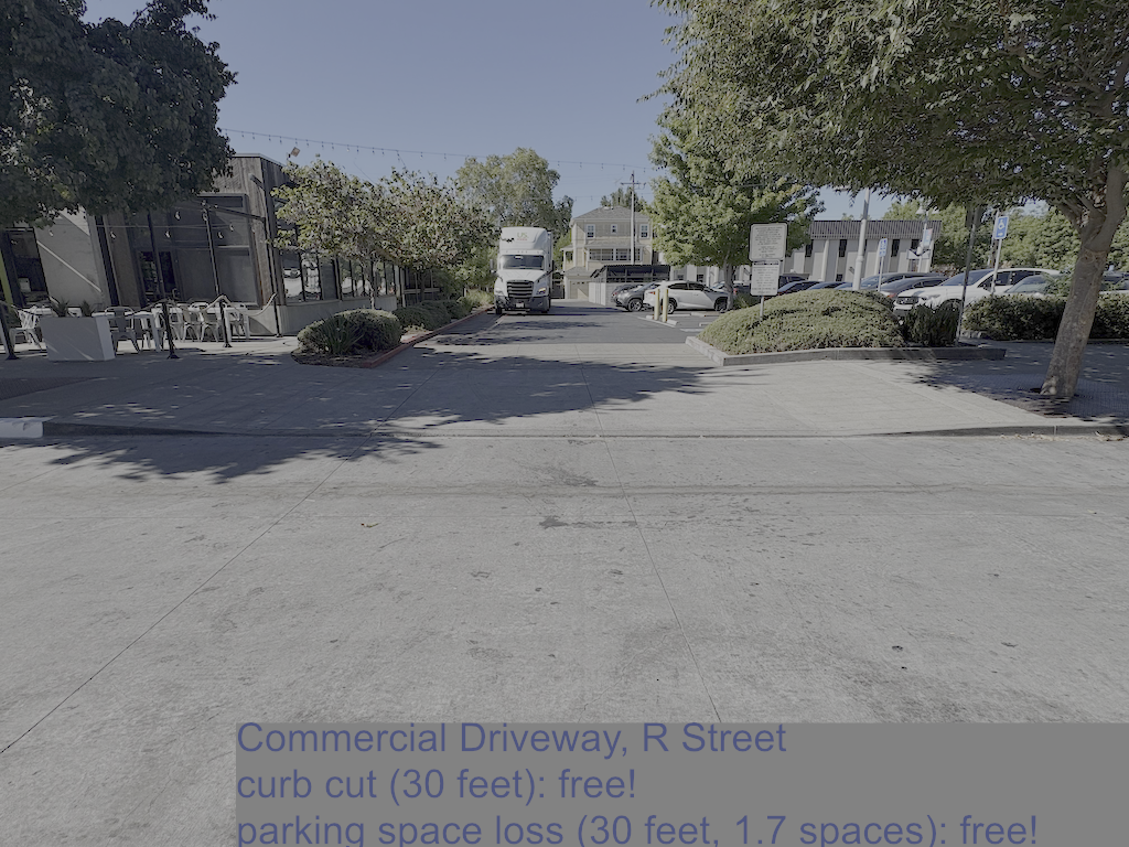
So, the city is giving away space for a 30 foot wide driveway on R Street, including loss of about 1.7 parking spots and the income therefrom. Note that this parking area has access through Rice Alley; the R Street curb cut and driveway is not actually needed.
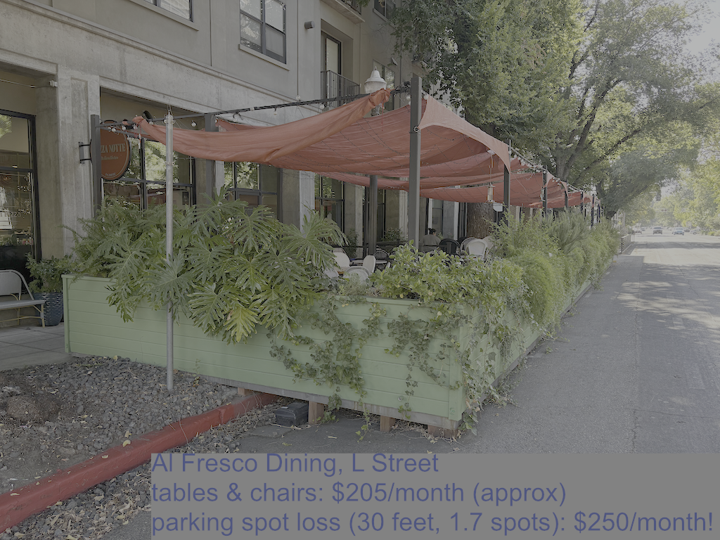
On the other hand, the city is charging the business on L Street for the Al Fresco area, about $455/month, for the same curb space and parking spots. Note that the two areas are not the same size, L St is about 90 feet long, so the Al Fresco cost is estimated for the same size area.
How does the city value curb space and parking spaces?
Dewey is a high speed, very wide road, that is empty much of the day, but extremely congested during school arrival and dismissal times. Though there is a signal at the school entry/exit, with pedestrian signals, those previous improvements have not made the street safe or comfortable for anyone. More needs to be done, and the students came up with a plan, working with county transportation staff, to calm traffic and make crossing safer and more welcoming. The county will apply for a grant to implement the plan.
I was the Safe Routes to School Coordinator for San Juan Unified for 10 years, and tried several times to interest the school in improvements, without success. It took motivated students, motivated teachers, and county staff enthusiastic about working with the school to make the difference. And the participation of the new Safe Routes to School Coordinator, Natalee Dyuduyk.
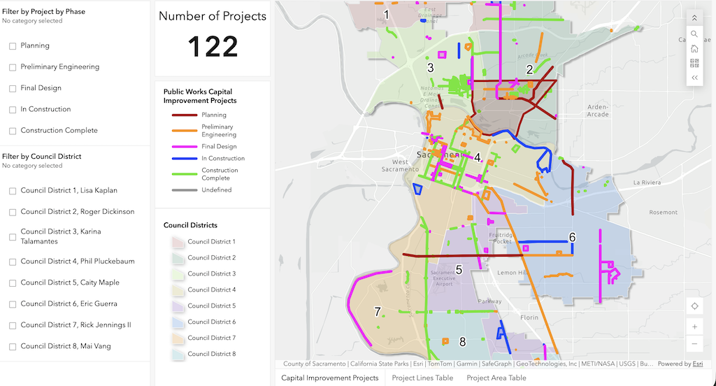
The City of Sacramento, Department of Public Works, has an map or dashboard of transportation projects available online, Public Works Transportation Projects. You can select by project phase (planning, preliminary engineering, final design, in construction, and construction complete), and by council district. You can zoom in or out on the map.
Public Works Transportation Projects map/dashboard
Clicking on a project line or point opens a popup with details. Some of the data seems a little out of date for Project Manager and project phase, but this is nevertheless the best source of information on projects that I am aware of.
For transportation advocates, selecting planning will probably be of the most interest. Once a project is past the planning stage, it is unlikely that it can be improved by community input.
Public Works Transportation Projects map, selected for ‘Planning’
Sacramento County does not seem to have an equivalent map/dashboard, but it does have a project page.
Folsom does not seem to have an equivalent map/dashboard.
Rancho Cordova has a robust set of GIS data, but does not seem to have an equivalent map/dashboard.
Elk Grove has a robust set of GIS data. It has a CIP (capital improvement program) map, which may contain similar information, but does not seem to be working at this time.
I have a number of friends who are car free. Like me, they have flexibility in their lives, and time to plan traveling. But several of them also have families and manage to be car free. I recognize it is a challenge, and acknowledge them for the effort. I have a larger number of friends who are car light, own and use a car sometimes, or in some cases, do not have a car but rely on ride hail for many trips. They don’t usually drive, but do for several reasons: they are late, they have to haul more than is comfortable on a bike or walking, they have family members who need to get somewhere and don’t drive (kids and elderly), and they want to go to the mountains or the ocean, both of which are possible without a car but more awkward.
I’m not judging people for not being car free, or using a car sometimes. Life is what happens. I am privileged to lead a life where I do not want to drive, do not need to drive, and have the time to plan trips by other modes. I have no one dependent on me for transportation. I have not owned a car in 15 years, and have not driven a car in 6 years, and now I don’t even have a drivers license. I save a huge amount of money on not have a car and all the accompanying expenses, but I do spend quite a bit on train and transit travel. And I am happy with the additional time it takes to get places. I am not a stay-at-home person, I’m more active that most of the people I know.
But I challenge everyone to pause before driving. Am I driving because I am lazy, or tired? Am I driving because it seems to hot, or too cold, or too windy? Am I driving because it is more convenient or faster than other modes? Am I driving because I forgot to plan ahead to get there some other way? Am I driving because the car keys were right there by the door? Am I driving because I spent a lot of money on my car, and I feel like I need to get the value of that by driving it? Am I driving because it increases my visibility and stature with others (is my car part of how I define my worth)?
Most importantly, could I defer or cancel this trip? Is is really that important? Could I do it tomorrow, or next week, or not at all?
If you think that driving less is good for you, good for your family, good for your community, and good for the earth, then start now. One less trip a week. And another less trip next week. That is actually how I got to car free over several years, driving less and less each week, each month, each year. One attempt at a mode you don’t use, or don’t usually use. Make a plan and use transit. Plan ahead and bicycle or walk. Stay home and enjoy your home. Walk to the coffee shop or bar and enjoy the company.
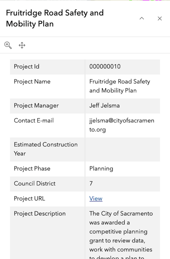
I posted on the Fruitridge Road Safety and Mobility Plan (2026-02-21), which was before the first community meeting on March 4, which I attended. There were a number of display boards with details that are not necessarily in other documents, but I did not capture those. A second workshop, on July 6, which presented updated concepts based on the first workshop and other outreach, I was not able to attend. The project website has a number of documents of interest, including all those that I reference below. Note that there is another city project, Fruitridge Road Improvement Project, east from Stockton Blvd to Power Inn Road, that is separate from this project.
The public outreach for Phase 2 is complete, and there is no formal process at this time for public input. However, you have the right as a citizen to email the project lead, Virginia Morgan, VMorgan@cityofsacramento.org.
Overall
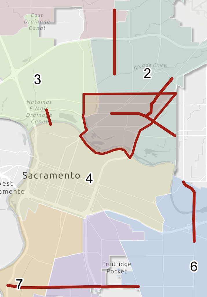
The map below shows the corridor, and related transportation projects.
map of Fruitridge Road Safety and Mobility Project
The project extends from Riverside Blvd to on the west to Stockton Blvd on the east. The roadway from Riverside to South Land Park Drive is named Seamas Avenue, which is important if you are looking at details in the documents, but I’ll refer to the entire corridor as Fruitridge Road. The section from Riverside to Freeport Blvd is four lanes, but with fairly low traffic volumes and speeds. The posted speed limit is 35 mph. From Freeport to 24th Street, volume and speeds are higher, and the roadway has frontage roads on south and then north side. The posted speed limit is 40 mph. From 24th all the way to Stockton Blvd, the corridor is mostly commercial, with some residential here and there. Volume and speed are again higher. The posted speed limit is 40 mph, but observed speeds are much higher, particularly in the vicinity of the Hwy 99 interchange, where drivers reach highway speeds at the onramps, and continue highway speeds coming off the off-ramps. The section from east edge of the freeway interchange to Stockton Blvd is mostly within Sacramento County, not the city. This section has paint-only bike lanes, which apparently were added in 2024.
Traffic Violence
The corridor map below shows collisions. As is no surprise, they are concentrated at major intersections, but also occur in between, most likely at side streets or driveways. Few collisions are shown for the Hwy 99 onramps and off-ramps, possibly because this data was not included. Though the interchange is within the city, it is completely controlled by Caltrans and collisions would be reported by CHP, not the city. When I asked the consultants why the collision density was so much higher in the county section than the city section, they speculated that it was because there was so much more commercial activity and driveways in that section.
Sidewalks
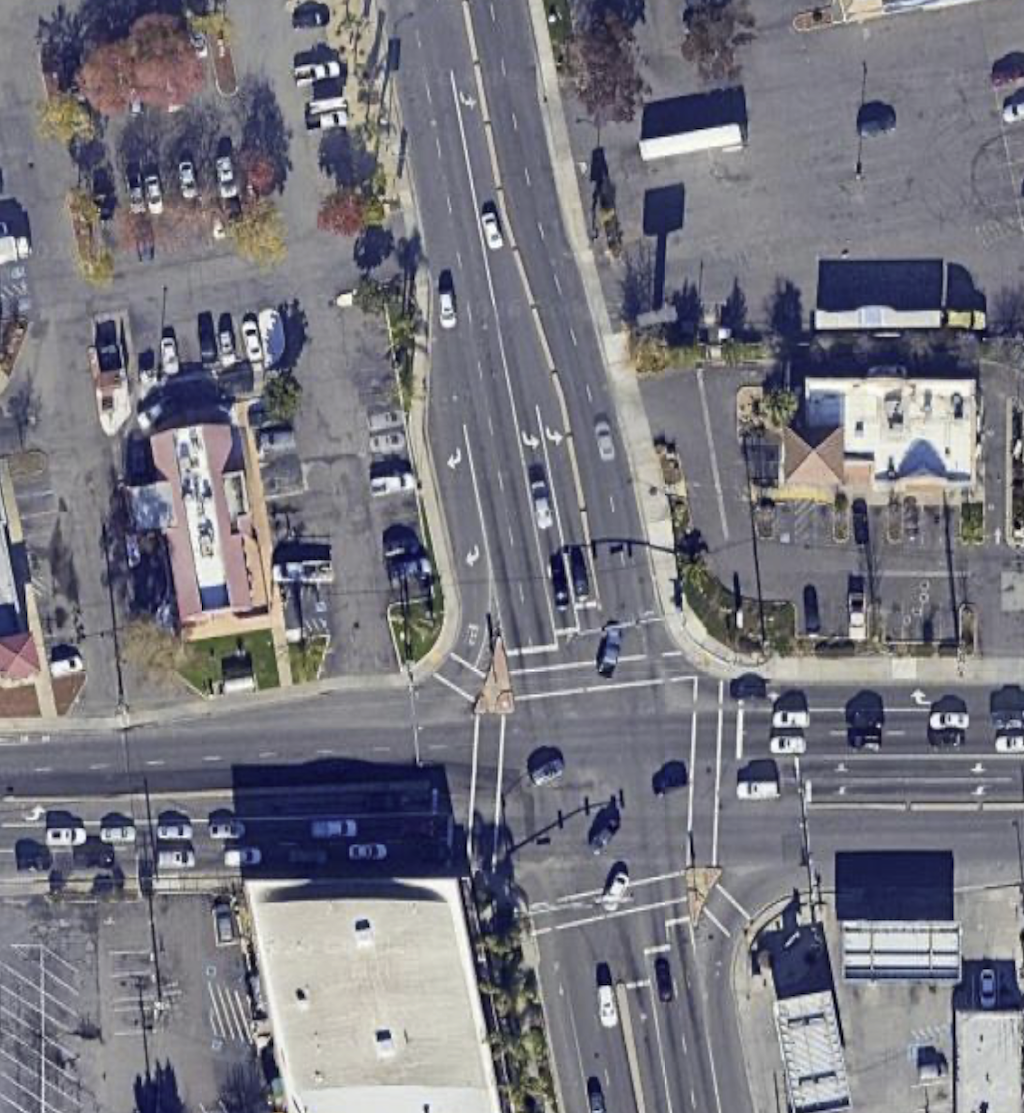
With few exceptions, sidewalks throughout the corridor are five feet wide. Though there are problems here and there, including utility poles in the sidewalk, and a gap east of the Del Rio Trail, they are overall in decent condition. The lack of trees along this corridor does reduce sidewalk heaving. Driveways are frequent, particularly between Franklin Blvd and Stockton, including the county section. More than half of the driveways have a steep cross-slope in the sidewalk, not meeting current PROWAG/ADA requirements. Some, mostly within the county section, have been fixed with the ramp down, ramp up solution, which is legal but not optimal. Many of the unmodified driveways present barriers to travel with mobility devices, and discomfort for all walkers. All sidewalks and driveways within the project area should be upgraded to PROWAG compliance. The best way of doing so it to install a sidewalk buffer (which the city calls planting strips) so that the driveway slope in within the buffer, not within the sidewalk.
side-sloped sidewalk at driveway, not PROWAG/ADA compliant (and overly wide driveway)
Sidewalks should be a minimum of six feet wide, with additional width where higher walker use justifies it. Initially, the project proposed to leave almost all of the sidewalks untouched, only widening them where there are bus stops. The new Alternative 2 – Enhanced Improvements, considers but does not promise widening sidewalks along the corridor. More on this below.
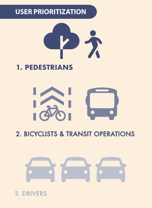
I keep harping on the city’s user prioritization diagram, from the 2024 General Plan, but it is worth remembering for every single project. Not only does it show pedestrians (walkers and rollers) as the top priority, it shows a tree with the walker. The tree is essential for creating a welcoming and safe environment for people walking. But trees are the one feature most neglected in transportation planning and infrastructure. Every city project has resulted in fewer trees than were promised, despite trees being one of the top requests by the public.
Roadway re-allocation
The project plan focuses on lane number reductions and lane width reduction, and the question of whether the eastern Segment 2 from 24th Street to Stockton Blvd will be two lanes (three with center turn lane) or four lanes. I don’t think this is the most important issue, except as re-allocation allows for wider sidewalks and sidewalk buffers. I find that Alternative 2, illustrated below, is the only acceptable design of the three presented. The diagram shows a section without driveways, but frequent, poorly designed driveways are characteristic of much of Segment 2. Only this alternative allows continuous level sidewalks, with driveway ramps in the sidewalk buffer. Though at this stage of planning, the width of the widened sidewalks and new sidewalk buffers is not specified. I believe that sidewalks should be a minimum of six feet, and wider where walkers and rollers are more frequent. Bus stops should have at least eight feet of sidewalk, and most bus stops should have bus shelters and other amenities that are not within that eight feet. Buffers should be a minimum of eight feet, to allow for tree health and growth without sidewalk buckling. The city has been using buffers of 4 to 6 feet on many projects, which is too narrow.
The Phase 2 Design Alternatives document, which I assume must have been the display boards at Workshop 2, does have widths shown for the various segments, but unfortunately, these diagrams do not exactly match the diagrams in the presentation. For example, the presentation Alternative 2, below, indicates widened sidewalks, but the design alternatives document continues to show the existing five foot sidewalks.
Sidewalks should also be continuous across intersections with local streets. These raised crosswalk/sidewalks clearly communicate to drivers that they need to slow, and look, when crossing a sidewalk, that they are guess in the walker space, not the preeminent user. There may be intersections with collector and arterial roadways, and other signalized intersections, where continuous sidewalks/raised crosswalk are appropriate.
Bicycle facilities
Alternative 1 shows paint-only Class 2 bicycle lanes. These are unacceptable on roadways over 30 mph, and with the current speed limits at 35 mph and 40 mph, they are not safe. Unless posted and design speed limits are reduced to 30 mph on the corridor, bicycle facilities must be protected with at a minimum, wide buffers with vertical delimiters, and preferably and safer, concrete medians and curbs. Without width specification, it is unknown whether these facilities will accommodate modern bicycles and riders. But as with all bicycle facilities, the more important issue is how bicycles are accommodated at intersections. The city has not done well with this issue.
Intersections
Intersections are where most collisions occur, and the locations where walkers and bicyclists are most at risk, and most discouraged, but the documents available to date don’t show intersection modifications.
There are two intersection in the corridor that must be significantly modified to make them safe for all users. At Fruitridge Road and Freeport Blvd, the intersection flares to have five westbound lanes, with two dedicated left turn lanes, two through lanes, and one dedicated right turn lane. A crossing distance of 113 feet! Eastbound, four lanes, with one dedicated left turn lane, two through lanes, and one dedicated right turn lane. A crossing distance of 100 feet! There are problems with the design of Freeport Blvd as well.
Fruitridge Rd & Freeport Blvd flared intersection
The intersection of Fruitridge and 24th Street is acceptable, though it could certainly be improved.
The intersection of Fruitridge and Franklin Blvd is unacceptable, with a similar flared design. The free right turn slip lanes from Franklin to Fruitridge are a clear and present danger to all users of the roadway, particularly walkers and bicyclists. These should have been removed as part of the Franklin Blvd Complete Streets project. And they should be removed citywide.
Fruitridge Rd & Franklin Blvd flared intersection
The intersection of Fruitridge Rd and Stockton Blvd is the third problematic intersection, though it isn’t clear to me whether changes will be part of this project, or the future Stockton Blvd Stockton Transportation Enhancement Project. On Fruitridge, it is not as bad as the two preceding intersections, but the intersection is a vast area of pavement, unfriendly and unsafe for walkers and bicyclists.
These flared intersections create large number of conflict points for motor vehicles, and lengthen crossing distances for walkers to unacceptably long distances. Long crossing distances also slow signal cycles due to the longer pedestrian crossing time, frustrating drivers as well. They also encourage drivers to jockey for position at intersections, and accelerate hard to get ahead of others. Though not a common behavior, belligerent drivers also use turn lanes as bypasses for slow traffic in front of them, creating a high level of danger for everyone. The city has, in the past, installed these flared intersections to create stacking space for motor vehicles at signals, but shortening signal cycles can have the same beneficial impact.
I believe intersections should never have dedicated right turn lanes, and particularly, not ones leading to free right turn slip lanes. Right turning drivers can wait their turn with everyone else. Intersections should only have one dedicated left turn lane. Two or more turn lanes lead to motor vehicle conflict on turns, higher speed turns, and inattention by drivers to people in the crosswalk and bicyclists. Whether there are one or two through lanes (never three or more), depends upon the intended design use of the road. Not on existing traffic counts, but on intended use.
Hwy 99
The worst ‘intersection’ of all is the Fruitridge Road & Hwy 99 interchange. This interchange features three high speed onramps from Fruitridge Road to Hwy 99, and three high speed off-ramps onto Fruitridge Road. It is not a true cloverleaf interchange, which would have four of each, but it is bad enough.
On eastbound Fruitridge, the south side, bicycle lanes are dropped, and so are sidewalks. There are ‘no pedestrian’ signs approaching from the west and east. There are no marked crosswalks or pedestrian warning signs or ramps over the two onramps and one off-ramp. The sidewalk on that side is basically an isolated fake. I watched these ramps for some while. Drivers were entering the onramp to Hwy 99 southbound at highway speeds, far over the posted 40 mph speed limit. The off-ramp on northbound onramp were not as bad because they lead to fairly tight turns, and presumably most drivers know that excessive speeds will cause roadway departures.
On westbound Fruitridge, the north side, bicycle lanes are dropped, but there is sort of a sidewalk. There are sidewalk ramps to unmarked crossings of the one onramp and two off-ramps. There are even pedestrian crossing signs at each, and the west off-ramp, even added yield signs, though those may be for merging to Fruitridge, and not for the crosswalk. I watched the west off-ramp for a while. Every driver was exiting at highway speeds, though the posted speed limit is 40 mph.
I believe that all freeway interchanges should have right-angle entry and exits from surface streets, which cause drivers to stop, or at least greatly slow. If a walker or bicyclist got hit at such a ramp, it would be a low speed collision, and probably survivable. For the high speed ramps of this interchange, a collision with walker or bicyclist would almost certainly be fatal. When a city or county want to redesign an interchange to be safe, Caltrans response is almost always: ‘we’ll work with you on the design, but you are going to pay for the infrastructure, 100%’. Caltrans knows that its interchanges are deadly, but has no interest in fixing them. Cities and counties can rarely afford to do so. As for the lack of mapped collisions (see diagram above), I believe that collisions that happen at the exit of the off-ramps and entry of the onramps are considered to be on a state highway, under the jurisdiction of CHP and not Sacramento Police, so don’t show up in the city’s data.
Fruitridge Rd & Hwy 99 interchange
Bus stops
The designs use the phrase ‘Transit stops will need to be designed to accommodate bikeways’, but there are no diagrams or descriptions of what these would look like. This is a very important issue. The optimal bus stop is at a transit boarding island where the bus stops in the travel lane rather than pulling out of traffic. However, other options are possible and may be more compatible with the overall roadway design. An unanswered question.
The Upshot
Segment 1, from Riverside Blvd to Freeport Blvd, at perhaps at far as 24th Street, should be delayed. The traffic on this section is lower volume and lower speed than the rest of the corridor. Though it would be easier to re-allocate roadway width here, it does not have the same safety value. For Segment 2, to the east of 24th Street, and perhaps including the section from Freeport Blvd, the nature of the roadway, driver behavior, conflict points, and adjacent land uses changes completely. This is where the real problem is, and should be the focus of the project.
Hazardous intersections, particularly at Freeport and Franklin, must be fixed in this project, and these intersections are more important than fixing the corridor, because intersections are where the most conflicts occur, and therefore the most collisions. Even if the city fixed only those two intersections, the project would be progress.
Sidewalks for walkers and rollers are the most important aspect of any re-allocation project, of course more important than motor vehicle throughput, and even more important that bicyclists. Only Alternative 2 provide reasonable infrastructure for walkers and rollers. Sidewalks must be a minimum of six feet wide, even in low-use sections, and wider or much wider in heavily used sections. These sidewalk must be shaded by trees, which must be planted at about 30 foot intervals within sidewalk buffers (planting strips) of at least eight feet wide. Of course that means robust irrigation for trees and other plants during the period of establishment.
Wide concrete buffers, of the sort shown in Alternative 1 – Base Improvements, are a waste of concrete. Wide concrete buffers (8.5 feet!) are no more protective of bicyclists than 18 inch buffers, are a waste of project funds, and add to heat island effects of the roadway. The new Franklin Blvd Complete Streets unfortunately has a number of these. Don’t use them!
The city continuously refuses to reduce posted speed limits on reconstructed streets, with their faulty logic that speeds cannot be reduced without a speed study that shows lower 85th percentile speeds. But reconstructed, complete streets are essentially new streets, as though they had been constructed from scratch. The city can, and should, determine an optimal design and posted speed (which should be the same, not the over-engineered forgiving design speed of 10 mph or more over the posted speed). For this project, the design and posted speed should be 30 mph. Designing for slower traffic is even more important than reducing travel lane numbers.
I live in midtown Sacramento (well, a hundred feet west in downtown), and I love it. Why? Everything I need is close. Groceries, entertainment, parks, tea, medical, all within walking distance. But one of the things I enjoy most is just people watching. If often go to coffee shops for tea, but I can make great tea at home for a lot less money. But I go to people watch, and to socialize. For any business that has outdoor seating, even better people watching. In Fremont Park adjacent to where I live, people watching of all sorts: families, kids, Jehovah’s Witnesses on break, homeless folks of all different situations, people passing through the park, as I do every day, and people hanging out. And just walking around midtown, lots of people to watch, particularly when on cool mornings and evenings, and on the relatively few nice days in summer.
There is no place else I could live in this region, except perhaps Fair Oaks Village and Historic Folsom, where I would see so many different people. More white in the old suburbs, for sure, but nevertheless, some diversity.
That is a big part of the reason I live here, and enjoy it so much.
The County of Sacramento determined that there were insufficient valid signatures for the SaferSacStreets initiative to be on the November 2026 ballot.
Below is an email sent to supporters.
This leaves the City of Sacramento efforts to make streets safer for all users without the funding needed, since the city allocates very little general fund money to street safety. It leaves SacRT without funding needed to enhance existing bus service, particularly increasing frequency and span of service on high ridership routes.
We are saddened today to report very disappointing news. The Sacramento County Registrar of Voters has determined that the Sacramento Safe Streets and Affordable Transit Measure of 2026 did not have enough valid signatures of registered City voters to qualify for the November ballot.
As we reported a few weeks ago, the campaign delivered over 32,000 signatures to the City Clerk on June 30, 2026. By submitting 10% more than the statutory minimum, the measure qualified for a random sample count. A full count would have taken three months and would not have allowed the measure enough time to qualify for the November ballot.
We are currently inspecting the petitions and the County’s random sample count verification process to determine if there were any possible errors or other factors that could lead to the measure qualifying for an election in 2028. However, it is clear that the measure will not be on the November 2026 ballot.
This result is heartbreaking for all of us who have invested so much time, expense, and energy into bringing this measure forward. We always knew it was a long shot to mount a citizens initiative that was so short on time and money, despite the tremendous support and enthusiasm from all of our volunteers and supporters. We will update you as soon as we can, including future options. You can also check our website for updates at http://www.safersacstreets.com
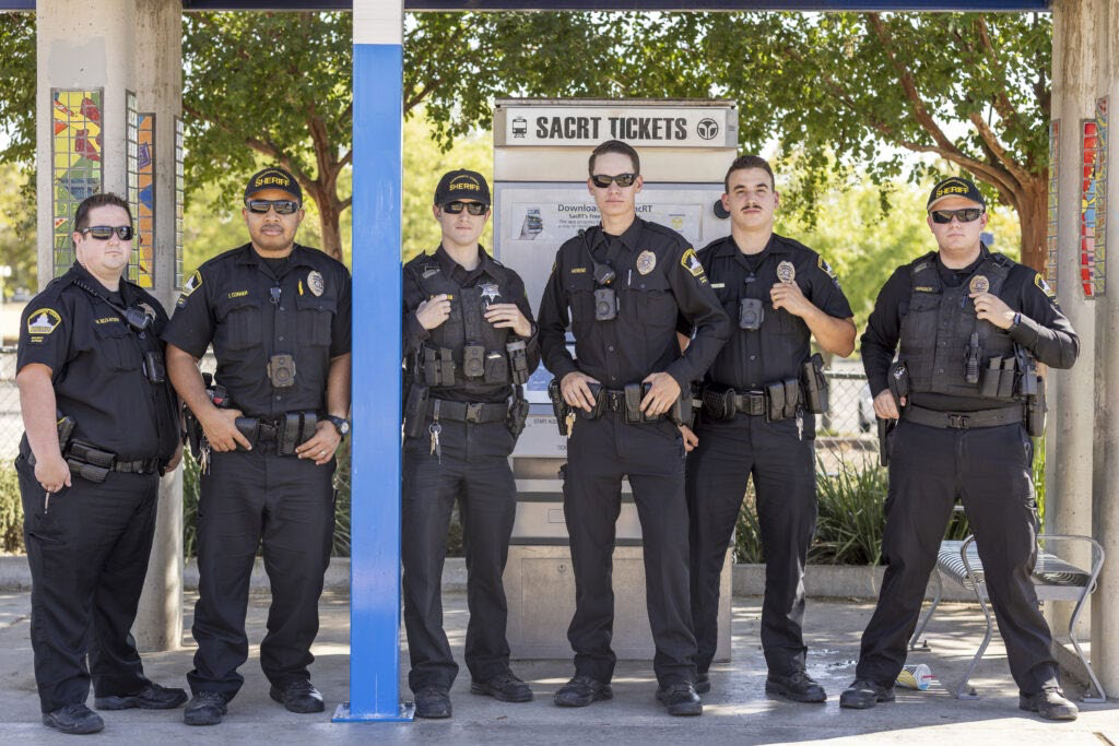
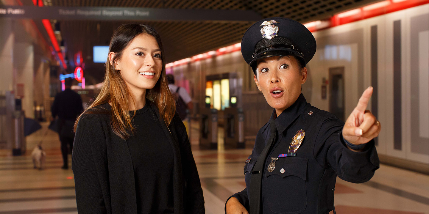
SacRT photo of Sheriffs Department officersMetro photo of LAPD officer and rider
SacRT staff Lisa Hinz presented a justification for zero tolerance fare enforcement on light rail at the 2026-07-27 board meeting. She used Metro (LA country transit agency) as an example, but mis-used it in a way that contradicts her point. So, fair game, this is real information from Metro. Hinz used the photo on the left in her presentation. The photo on the right is from the Metro Safety Team page, Law Enforcement Partners. A picture is worth a thousand words. Enough said.
If you wish to look at Metro’s approach to safety, including their nine related positions, see Metro Safety Team webpage. The position descriptions are available.
San Francisco is a transit-first city, though it falls short of that goal. Other major cities are so clearly transit-first that they don’t even remark on it. The Sacramento region will never be a transit-first place. Density is too low, almost everywhere, except the Sacramento central city. Opposition to transit, both ideological and anti-tax, is common in the region. But we could designate transit-first roads.
SacRT’s High Capacity Bus Service Study (2021) outlines several possible BRT (bus rapid transit) routes in the county, shown on the map below. It missed critical corridors, however. It missed BRT to the airport, because at that time SacRT was still selling the idea that light rail to the airport would occur in the not too distant future. It missed Greenback Road connecting Sunrise Transit Center and Historic Folsom light rail (yes, this travels through low density areas, but would provide a connection between high use areas that do not currently have any connection whatsoever). It also missed Cosumnes River College light rail to Elk Grove, as the planning effort for BRT or light rail came to prominence after 2021. It also includes some routes of doubtful utility because they extend beyond high riderships areas into areas of low density development, Sunrise south in particular.
These corridors are not designated by the cities, or Sacramento County, or Sacramento Transportation Authority. But a designation of these as transit-first roads would have several benefits for planning and funding.
A recognition that planning and projects should first consider the transit function of that road, before any consideration of motor vehicle throughput.
A recognition that there are many possible levels of transit support, not limited to or even requiring BRT. These might include signal priority, better bus stop spacing, better bus stops, bus stops in traffic rather than requiring pull-outs that cause delay and safety issues, signal queue jumps, bus only lanes full time or at congested times.
A recognition that existing arterials do not well meet the transportation needs of people because they were designed for and prioritize private motor vehicles, and are the primary location of traffic violence.
A recognition that the value of a particular transit-first road varies over time with other changes to the roadway, surrounding land use, and connections to other transit service. What has happened to date is that a focus on a particular corridor is usually a political decision (ribbon cutting) and not based on current use patterns and planning for a complete transit network. Planning then completely neglects consideration of other corridors.
If we designate a corridor as a transit-first road, then it allows incremental progress towards the eventual goal of BRT, or even light rail. We don’t need to wait until political will or funding to go for the huge project, rather, we can improve transit utility with every change to the road, and with much smaller amounts of funding.
I attended the SacRT board meeting yesterday. My report highlights things I am interested in, or grabbed my attention, and is not intended to be comprehensive. You can view the meeting video online at https://www.youtube.com/live/rtB9B2fXBck?si=p3M2Gf5JWfHK8AJg. An action summary will be available in the agenda of the next board meeting, scheduled for August 24.
One step forward, one step back. SacRT is again offering the public to make comments via Zoom, either in the Zoom app or by phone managed by Zoom. Good. Comments on the consent agenda (agenda items starting with 2) are now limited to two minutes total, rather than two minutes per item. It isn’t clear what will happen if a board member pulls an item from consent, for discussion. That did not happen in this meeting. Will that item be an exception to the two minutes total? And how would a member of the public know ahead of time that an item will be pulled, and submit a comment card?
Rosario Rodriguez was an alternate for Patrick Kennedy, as a County of Sacramento representative. She made a point in comments that she regularly uses light rail to commute. This resulted in applause from the audience, because it is unusual. Kennedy and Maple as sometimes users of transit, but not as often as Rodriguez. Yah!
Though it was not pulled from consent for separate discussion, there were several board questions and comments related to item 2.11 authorizing the Green Line BRT study. Serna was concerned by the lack of information about right-of-way easements along Truxel that will expire at some point. Dickinson, Budge, and Maple were concerned that a focus on BRT would handicap consideration of light rail in the future. As I have said many times, I don’t think light rail to the airport will ever be financially feasible. Every time there is an estimate of the cost, it goes up, is currently $2 billion, and would be billions more by that time it might come to planning and construction. There simply is no justification for such an expensive infrastructure project for such a low ridership and network benefit. I’m not opposed to the BRT planning effort, though I also believe that SacRT (and/or Yolobus) must demonstrate that there is a demand for better service by first implementing 30 minute bus service to the airport, which does not exist because SacRT did not align its schedule with the Yolobus 42A/42B schedule.
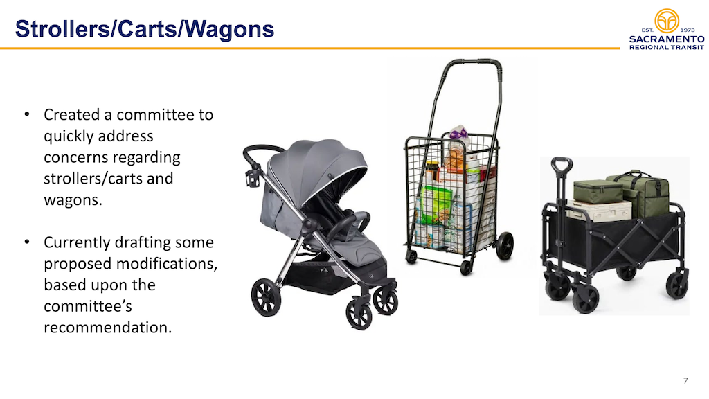
For agenda item 3.1 Customer Service Response to Feedback and Comments, Lisa Hinz gave the usual glossing-over-problems presentation. The two items of most interest to me and many transit advocates are the zero tolerance policy, particularly for fare evasion, and the policy requiring strollers and carts be emptied and folded.
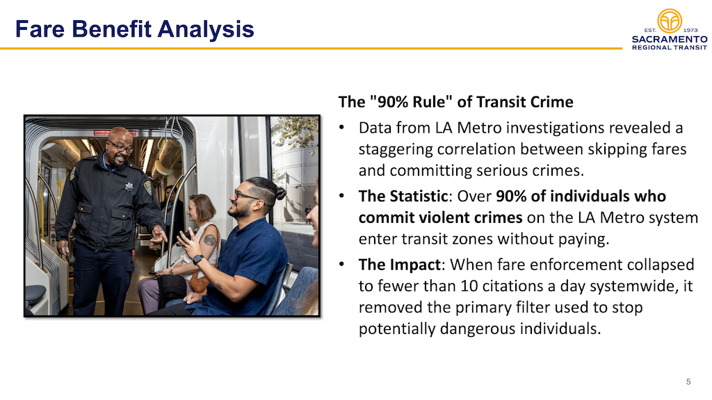
Hinz presented a slide, below, the implication of which is that if there were not a zero tolerance fare evasion policy, light rail would be a completely lawless zone, unsafe for everyone. BS. The previous practice of asking people who did not have proof of payment to exit the train at the next station seemed to me to be working just fine. Zero tolerance was extended not just to people who intended to not pay, but to everyone, no matter issues with the Connect Transit Card readers, or Transit Connect app, or any other method of payment. This zero tolerance policy is a typical law enforcement response to any problem to maximize enforcement no matter what the effect on riders. This is unacceptable. Hinz said that warnings are now being given rather than tickets, but I’ve seen reports that say otherwise. No explanation was given for how this zero tolerance policy came to be, nor what would replace it if it is not continued. Let me state clearly that I am not against fare checking, but what needs to be appropriate and rational is the response to evasion. Hinz used convoluted logic to imply that every fare evader is a criminal who is almost guaranteed to commit crimes on light rail. BS.
I am a moderately frequent user of Metro (LA) subway and light rail. There is a strong presence of both law enforcement and transit ambassadors, particularly on subway, and that system has more series issues than Sacramento. What I have not observed is incidents being escalated by staff, and I have observed particularly ambassadors and to some degree law enforcement being friendly and helpful when there is not an incident. This is not what is happening on SacRT light rail.
excerpt slide from 3.1 Customer Response, Fare Benefit Analysis
Hinz also addressed, vaguely, concerns about the stroller and cart policy. Again, this policy was being handled as zero tolerance, but I don’t know how it is being handled at the moment. Hinz said that a committee had been formed. I asked whether this committee included a representation of the Mobility Advisory Council (MAC), or a parent with kids in strollers, or a user of shopping carts, or a bicyclist, or for that matter, anyone who rides light rail. I strongly suspect not. I’m almost certain that it is an internal committee, composed of SacRT staff who don’t regularly use transit, if at all. Most SacRT employees, particularly administration, do not use transit.
excerpt slide from 3.1 Customer Response, Strollers, Carts, Wagons
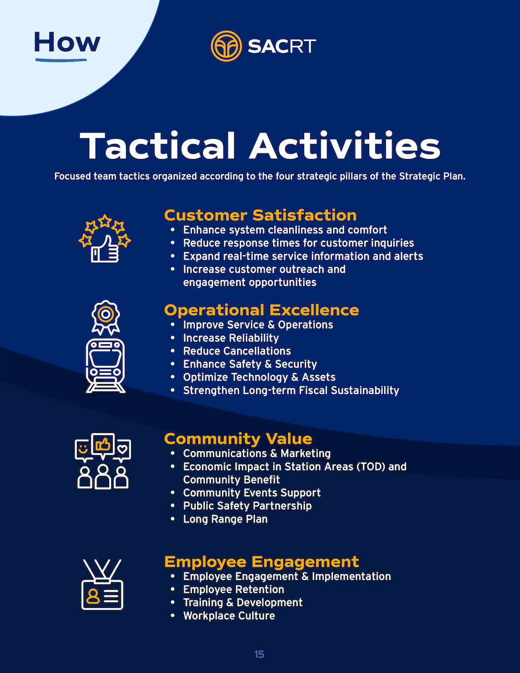
The main agenda item was 5.1 Draft Sacramento Regional Transit District Strategic Plan 2026-2030 (staff report | draft plan). This draft plan is just the executive summary, the draft plan itself is not available at this time. I had skimmed the plan before the meeting, and was left wondering what the point of the plan is. It really says almost nothing about what SacRT will do to accomplish the four pillars (Customer Satisfaction, Operational Excellence, Community Value, Employee Engagement). The Tactical Activities slide (below) perhaps comes closest. But there are no performance standards for any of these in the document. Most of the things on the list could mean anything SacRT wants them to mean. What do they mean to riders? I’m not at all sure.
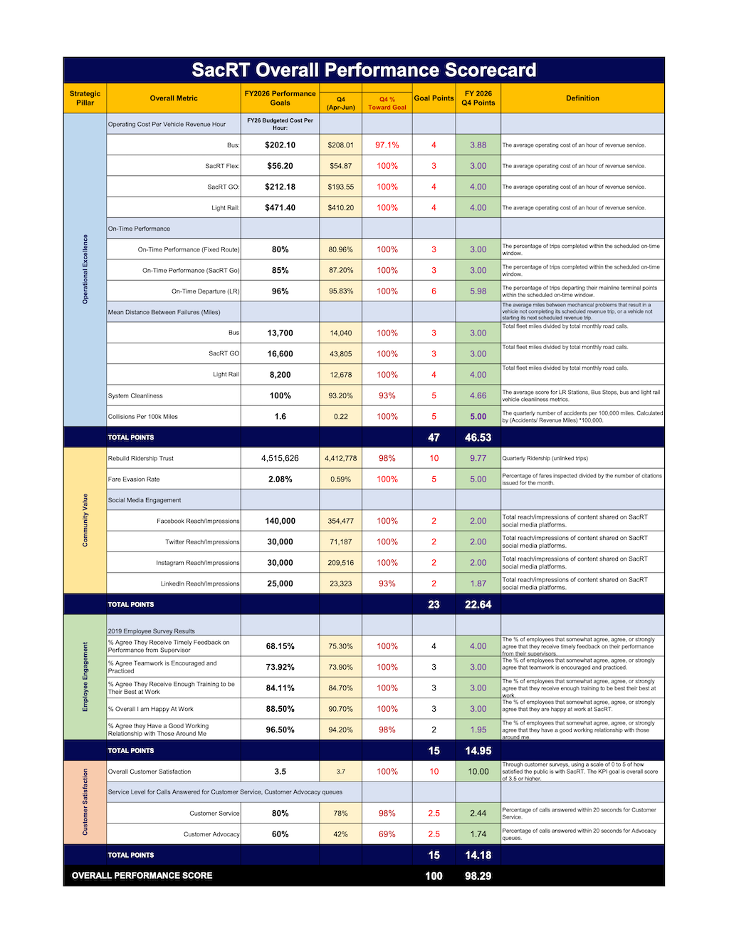
The verbal presentation used the acronym KPIs many times, without defining it. It stands for Key Performance Indicator. Reporting on implementation of the plan apparently will depend on the Quarterly Performance Reports, the most recent of which is below. This is a bean-counter approach. SacRT has been using this type of report for several years now, and every time it comes up in a board meeting, the public criticizes it for missing the point. It also always shows SacRT coming close to goals, though every rider knows that SacRT is far from reaching goals. Just more glossing over problems.
Dickinson asks where equity was in the strategic plan. The initial staff response was ‘everywhere’ but Dickinson did not accept that, and stated that it must be explicit in the document. The word equity occurs only once in the plan, on page 4. It is conspicuously absent from any of the lists. Dickinson also asked where the issue of first mile/last mile access to transit was, and why frequency of service was nowhere to be found. All good questions. Thank you!