I’m still in Philadelphia today, and will post some thoughts about the city tomorrow. But for today, I want to say again that smooth streets are dangerous streets. They encourage motor vehicle drivers to drive fast, too fast for conditions, and fast enough to kill any walkers or bicyclists they hit because they are driving too fast. Our street design encourages speeding, and rewards it. But we can design streets that discourage or even prohibit speeding.
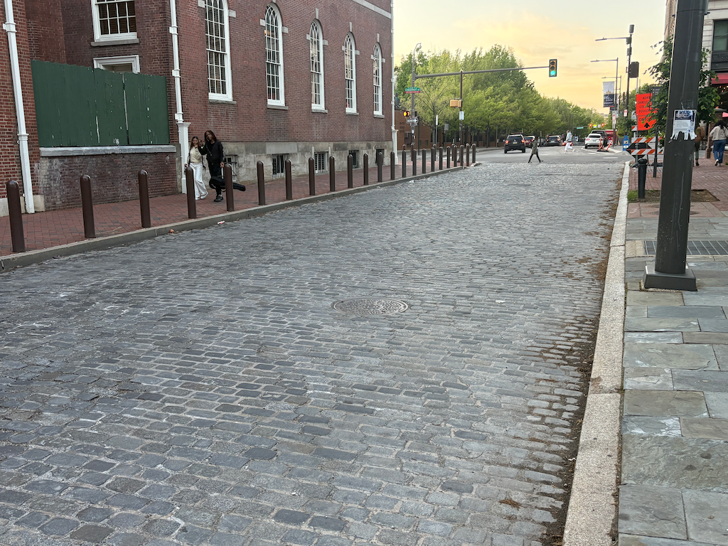
The street below, 5th Street in the historical and old city part of Philadelphia, is a street with an appropriate surface, cobblestone pavers. Of course it is so for historical reasons, it has been preserved, and probably reconstructed, to preserve the historical feel of the area. Independence Square is to the left. I watched traffic on this street for quite some time. I saw absolutely no one speeding. The cobble surface enforces reasonable speeds. Of course the width of the street is not optimal. It is not clear whether it is two lanes or one, and it is not clear whether parking on the right side is permitted or not. But that is actually part of the benefit, by leaving drivers a bit confused, they drive even more slowly and carefully.
And if a driver does error, there are metal bollards separating the street from the sidewalk. Why is the ‘old’ way to protect walkers from errant drivers, while the ‘new’ way is to leave walkers at the mercy of errant drivers.
I’m pretty sure that all the streets in the old part of Sacramento, both ‘Old Sacramento Waterfront’ and the western part of the central city up to the Capitol, were cobblestone. I’ve seen utility projects digging up streets reveal the cobblestone beneath the asphalt. People think of asphalt as being the modern thing, and cobblestone as being old fashioned, but the fact is, cobblestone is the advanced street design, because it keeps motor vehicle drivers to safe speeds. We need to get back to the ‘old’ and safe ways.
5th St cobblestone between Walnut and Chestnut, Philadelphia
For previous posts on parking in the City of Sacramento, see category: parking management.
The proposed City of Sacramento budget has increases in penalty fees for parking illegally, as documented in the recent SacBee article (Sacramento proposes hiking parking violation fees amid $66M budget shortfall, Ishani Desai, 2026-04-30). Not explicitly stated, but implied, is that parking fees will not be increased at this time.
I am glad that penalties will be increased, though I think they should be increased a great deal more. The ‘The fee for parking in a bike lane could increase to $150, up from $50.’ is great, though it should be much higher. Not called out in the list is parking blocking crosswalks. This may fall under one of the other categories, or it may not. When I have reported blocked crosswalks via 311, the report back is usually either no citation was issued, or the vehicle was gone, though I have observed many times that the vehicle is still there. Apparently the parking officers don’t consider blocking crosswalks to be a big deal. I do! The penalty for blocking a crosswalk should be enforced, should be a separate listed category, and should be $500. When people walking have to go outside the crosswalk to cross a street, it reduces their visibility and increases their exposure to traffic violence. This is not a victimless habit.
Increasing parking fees was one of the possible budget solutions proposed by Public Works, which controls parking in the city. The proposed budget does not increase parking fees. I understand this, given the current focus on affordability. But I think increased fees should be on the table. Even in the highest rate zones, the parking fee does not cover the true cost of providing that on-street parking space.
But the elephant in the room is that the city gives away free parking almost everywhere.
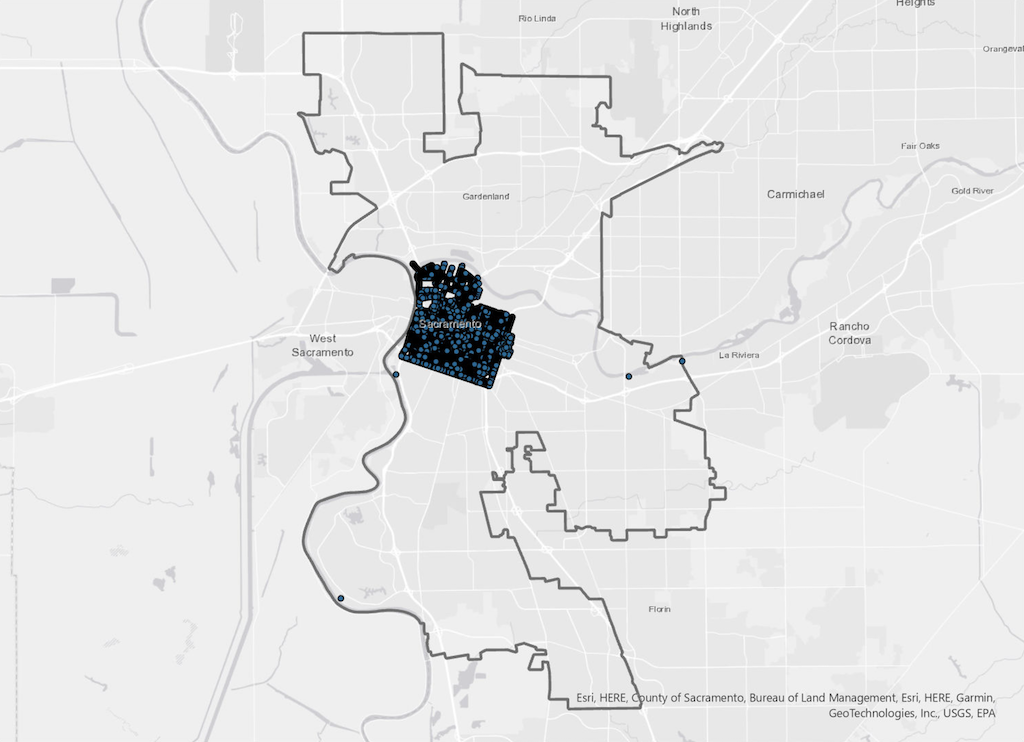
Residential parking permits, required to park in non-metered parking spots in the central city (the map below shows more or less where those zones are), are available to any resident. The cost? Free, zero, nada, zip. Residents can park their privately owned vehicle on the street within three blocks of their residential address, and pay nothing to the city for that privilege. See Residential Permit Parking (RPP). Charging a minimal fee for a residential parking permit would be a good start on actually managing parking in the city. How about $20 per month, or $240 per year?
How many vehicles are on the street with free residential parking permits? I don’t know, and there is no indication that the city knows, either. But is is clear that this income would make a big dent in the city budget deficit.
Even more egregious is that the city charges absolutely nothing in the vast majority of the city. The map below shows metered parking in the city, which is essentially just the central city. Outside this area, parking is free. Storing a private vehicle on public property provided by the city, and taxpayers? Nothing! These areas outside the central city are probably not a ‘valuable’ as the central city (though the cost of providing free parking is just the same), so maybe a offer a deal, $10 per month, or $120 per year.
How many vehicles are on the street in this vast free parking area? I don’t know, and there is no indication that the city knows, either. But is is clear that this income would make a huge dent in the city budget deficit.
Note that I am not proposing that additional areas of the city be metered, though there are arguments for metering some locations with high commercial and residential activity. The investment in meters, installation and maintenance, is worthwhile only where parking is heavily used, and turn-over is highly desirable.
SacCity boundary, and metered parking
There is no such thing as free parking. The cost of parking includes, but is not limited to:
the original cost of constructing the parking lane
the land value of parking lane that could be occupied instead by more productive uses
maintenance of the parking lane, including street sweeping, leaf season pickup, and pavement replacement
resistance from people parking for free to any change in the street that might decrease parking, while improving safety and livability; this might include wider sidewalks, bike facilities, and traffic calming measures such as curb extensions
increased heat island effect from black asphalt in the parking lane
increased storm runoff from the parking lane
I am not against on-street parking. It does serve a public need, and it does slow traffic speeds a bit through ‘friction’. But why do we give it away for free, ever, and particularly under a budget crisis? Because we privilege the desires of private motor vehicle owners over all other people and all other priorities.
One of the many reasons that I travel is to see transportation facilities in different places, ways in which cities have made active transportation and transit better, or worse. I’m in Philadelphia at the moment, and one of the features that has been implemented is…
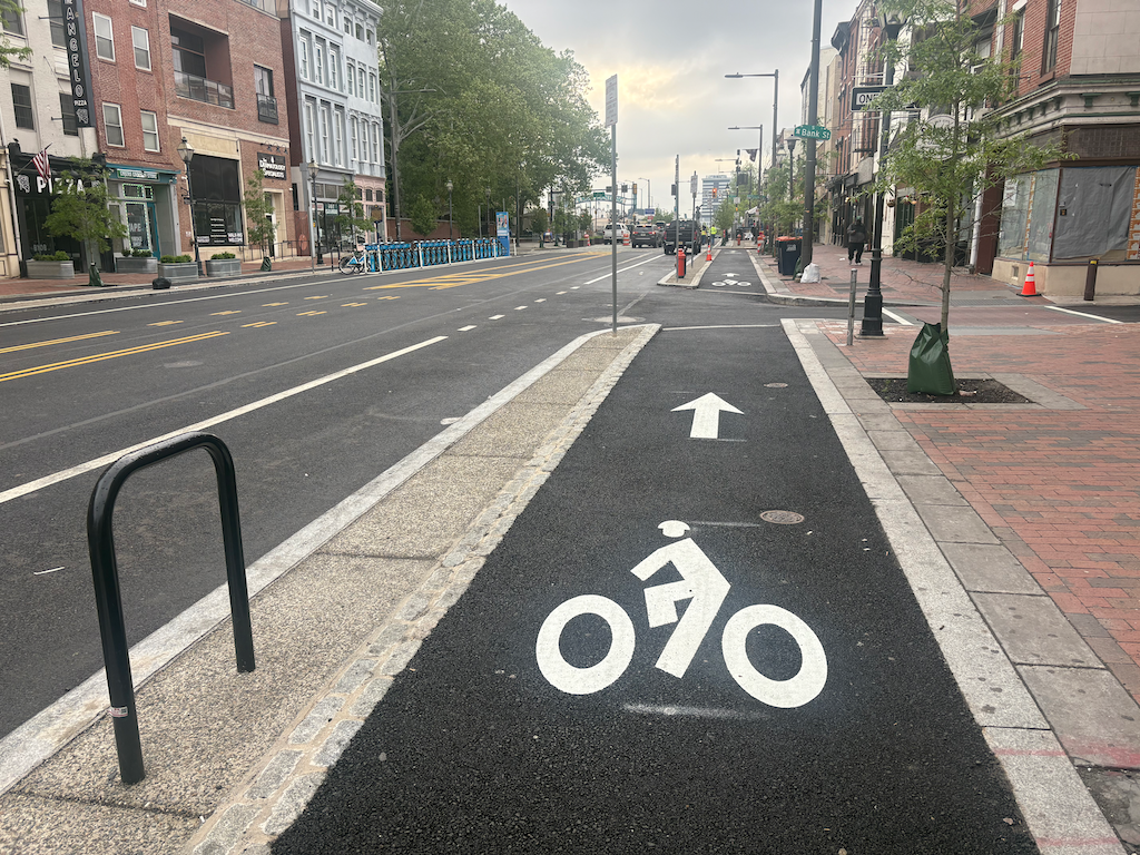
sidewalk-level bikeway on Market St in Philadelphia
These sidewalk-level separated/protected bikeways are on several blocks of Market Street, the main east-west street in Philadelphia. These are new, and were under construction during my last visit a year ago. NACTO calls these Raised Protected Bike Lanes, with designs on the Separating Protected Bike Lanes page (scroll down for this design section).
These bikeways are visually distinctive from the adjacent sidewalk, composed of different materials and colors, red brick for the sidewalk (many sidewalks in Philadelphia are brick), grey granite for the separation, and black asphalt for the bikeway. NACTO recommends a tactile warning delineator (TWD) between the sidewalk and bikeway. The granite separator and change of texture may or may not meet this criteria for visually impaired people. Though
Philadelphia downtown has a significant bicyclist mode share, but it mostly seems to be on the north-south arterials and collectors, not on east-west streets. But this may be an artifact of the time of day I observed. It has a wide variety of bike facilities: traditional bike lanes, vertical delineator ‘separated’ bikeways, two-way separated bikeways (cycle tracks), parking protected bikeways, bikeways along transit islands. I don’t know the criteria, but I suspect that available roadway width is a determinant.
Sacramento is proposing a sidewalk-level bikeway (2-way cycle track) on H Street between 9th Street and 10th Street, at City Hall. I believe the design is for paint on the existing sidewalk, not reconstruction of that section. It will be interesting to see if this design works.
I’m traveling on a Amtrak Rail Pass, three weeks from Sacramento to the east coast, and back. So far I’m mostly been in Boston and the Boston region of Massachusetts.
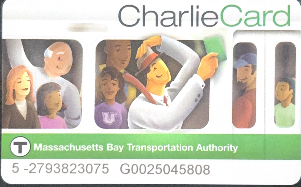
The transit agency is MBTA, Massachusetts Bay Transportation Authority. If you are as old as I am, you will probably remember the Kingston Trio version of “M.T.A.” where Charlie couldn’t get off the train because he didn’t have the exit fare: “Did he ever return? No he never returned, And his fate is still unlearn’d, He may ride forever ‘neath the streets of Boston, He’s the man who never returned.” MTA is now MBTA, but Charlie lives on through the CharlieCard, a fare payment card. Knowing I was going to Boston, I applied for a senior CharlieCard, which provides half off subway, light rail, and bus trips. The system is in transition, so the card is only proof of senior qualification, and fares can’t be added. Yet. But MBTA is one of the major transit systems that have implemented contactless fare payment, and also provides registration for contactless credit cards, so I could use my registered credit card to get the senior fare, $1.10 instead of $2.40.
The MBTA Commuter Rail lines, which go to distant suburbs, and even as far as Providence in Rhode Island, use the mTransit app, but I also get half off on that with the RTA senior card. I look the Framingham/Worcester line to Southborough, and then a local bus to Marlboro, to attend the New England Folk Festival (NEFFA). The train I took was an ancient single level train, with very worn seats, though I can’t pin down how old. There are also newer bi-level cars on the route. Both the bus and commuter rail have a much less frequent and less span of service on Sunday, so I caught a ride back into the Boston area and took the Red Line subway back to my hostel (which is only five blocks away from the Red Line).
I also used the Green Line light rail (which is underground in the central city) to get to the Museum of Fine Arts (MFA) and other destinations. This is the original but still existing service, and the cars are noisy and rickety, though much better than when I last rode about 30 years ago. The Green Line was also very close to my hostel, about two block to the Boylston Station at Boston Commons. I did not have occasion to ride the Orange Line or Blue Line subways. These apparently have nearly modern subway cars. There is also a BRT line that serves the airport and downtown, which I have not used.
The City of Boston is about 676,000 population over 48 square miles (14,000/square mile), in a MSA (Metropolitan Statistical Area) of 4.9 million over 49 square miles. For comparison, City of Sacramento is about 525,000 over 100 square miles (5,250/square mile), in an MSA of 2.5 million over an MSA of 21,500 square miles. Though the population of the two areas is not dissimilar, Sacramento has a primitive transit system while Boston has a world-class (for the US) system. Why? Density, density, density. Boston is three times more dense that Sacramento.
Of course transit in Boston started in 1834, and subway service in 1897. Sacramento didn’t even exist in 1834. In 1897, Sacramento had a population of about 30,000. Sacramento is a wet-under-the-collar cow town.
If Sacramento had developed as a dense urban place instead of a sprawl city, it could have had a transit system like Boston, below.
Boston has busy arterials, just like Sacramento. But off the arterials, there is very little car traffic. People get around on transit. About 1/4 of workers (which does not include people too old or too young to drive) are car-free in Boston, and even those that have motor vehicles do not use them on a continuous basis like many in Sacramento.
Yeh, that classic excuse of, well, Sacramento is not Boston. No, but it could have been. It could have been a real city, a ‘world-class city’.
I’m in Massachusetts for a folk festival. The town I’m in, Marlboro, has granite curbs (kerbs) almost everywhere. I had first seen these many years ago in New Hampshire, but apparently they are quite common in New England. Most historic districts require them, and they are used in many other areas as preferred by the town or city.
There are distinct advantages of granite curbs over the traditional western model of curb and gutter:
granite curbs last practically forever
granite curbs can be moved inward to narrow streets or widen sidewalks
gutters are not required
If a western street is changed, the transportation agency will almost always neglect the sidewalks in part because they don’t want to move curbs. Digging up and discarding curb and gutter is expensive and wasteful. Granite blocks are about 16 inches deep, but depth and width may vary. With granite curbs, simply dig a new trench and move the curb blocks to the new trench. If the curb needs to be reset, it can be done in short sections rather than tearing up long stretches of concrete.
Granite for curbs is more expensive on initial installation than concrete, roughly 1.5 times. However, concrete curbs may last as little as 30 years, while granite curbs are as much as 200 years old. Life cycle cost analysis indicates that granite is far less expensive in the long run than concrete, because the concrete must be removed, disposed of, and replaced. Looked at over a long period of time, granite is by far the most cost effective. It may be that granite would be more expensive in California. New Hampshire, after all, is ‘The Granite State’.
So called ‘modern’ curb and gutter is claimed to direct water flow away from the roadway to reduce roadway damage, but after looking at dozens of website about this design, not a single one actually explained why gutters were better than roadway profile where the drainage is to the granite curb. I suspect it is one of those street design engineering mythologies that has propagated without any research or proof.
Note that in the photo below, concrete sidewalk has been replaced or patched several times, but the granite curb is original.
I have become increasingly dissatisfied with attending and speaking at public meetings on transportation projects. Most of the time, what the public says make only minor difference in the project. No matter what the design stage, planners and engineers already have a pretty clear picture of what they want to build. Strong opposition may stop a project, but it rarely improves a project. This blog has had a larger impact than my meeting participation, and though my voice is important, it is only one voice and I can’t claim that it represents what the public wants. I have the expertise to speak to transportation planners and engineers in their own terminology, but very few people have that. Nor should need to have it.
A recent article on the Strong Towns website expresses what I have struggled to express. Please read it, and ponder it!
The upshot is that creating a temporary change to the transportation network, the agency can then get public feedback on their experience of using the project, not on some theoretical change that is hard to grasp. Temporary changes might include:
curb extensions with paint and vertical delineators
My favorite thing about living in a city, and about the cities I visit, is people watching. I love sitting with a tea or beer, and just watching people passing, or talking, or working, or reading, or writing. This is best when there is outdoor seating. A positive benefit of the pandemic (despite the horror) is that outdoor seating is much more common now that it was before. Outside is the best people watching. People are walking themselves, or their dogs, or their friends, or kids, or partners. Sometimes I make connections with other people, particularly people reading or writing in journals, as I am often doing myself, but the connection or just watching are both enjoyable to me.
People watching, and connecting, works best in dense places, with places to see, and places to meet. That means coffee shops (see coffee shops (tea) on the grid: update 2026-01), most of all, but breweries and restaurants and other businesses as well. Out in the suburbs, coffee shops are few and far between, and usually national chains when they are found at all. You might see people walking their dogs in the suburbs, but it is rare to see people walking to local businesses, or sitting outside. Where I live, coffee shops are thick, and breweries are to be found. Even small towns have a decent selection of coffee shops and sometimes breweries. As I write, I’m in Marlborough, MA, with several coffee shops and one brewery, and I’m looking out the window at people coming and going, and the coffee shop is busy on Sunday morning.
What does this have to do with transportation? Walkable places are where to see people, to people watch and make connections. Only places that are walkable and bike-able have this opportunity. Places that are drive-able don’t offer this. And that is why I very much dislike places that emphasize driving over walking and bicycling.
Spending time in small towns that are alive has made me appreciate that small towns can offer much of what cities offer, if they are old towns that have survived and thrived. Many small towns have not thrived. The problem with the place I’m visiting, Marlborough, is that it has poor transit, and infrequent connections to other transit, the MBTA ‘T’ commuter rail. If you can figure out a life in a small but vibrant town, that has a decent connection to the outside world, that may be the best livability you can find. But that combination is rare.
For previous posts on sidewalks and walkability, see category: sidewalks, and category: walkability.
Almost every complete streets and safety project the City of Sacramento has undertaken has focused on the roadway part of the street, the part where motor vehicles and bicycles travel. They have not focused on the sidewalks.
The ‘complete streets’ concept (note that I’ve placed it in quotes) emphasizes travel along corridors, not local travel and life. Lanes are narrowed or reduced. Bicycle facilities are added. A few safer crossings are added. Sometimes parking is reduced or eliminated. This is all good. But by designing and building this definition of ‘complete streets’, sidewalks are usually neglected. If a sidewalk is present, that is considered good enough. ADA ramps are added at corners, which is good, but the sidewalks in between corners are often untouched. There is a reason for this: repaving a street and then re-striping for different roadway width allocation is cheap (relatively). Replacing and widening sidewalks, and moving curb lines, is expensive. The result of a ‘complete street’ is a street that eases, and perhaps makes safer, travel by bicyclists and motor vehicle drivers, but does little for people walking.
It is bad enough that sidewalks are not improved, but by refusing to move curb lines, and/or to remove private development within the public right-of-way, the common issue of sidewalk buffers (which the city calls planting strips, though they may be used for many purposes in addition to planting) is perforce neglected.
Sidewalk width
Sidewalks should be a minimum of six feet, with widths up to 16 feet where the frequency of people walking justifies it. Many city sidewalks are five feet, and there are relict sidewalks of four feet. And of course there are many streets in the 50’s to 70’s developments that have no sidewalks at all. If a sidewalk is less than six feet, on a roadway that is being reconfigured or reconstructed, the sidewalk should be widened to at least six feet. Wider if justified by walking.
Driveways
In locations with sidewalk buffers, the slope of a driveway in often across the sidewalk, which makes the sidewalk dangerous for anyone in a mobility device, and uncomfortable for all walkers and rollers. Much of south and north Sacramento suffer from this design. Where it is present, it must be corrected. There is a correction available which ramps the sidewalk down and then up again across the driveway, and this is legal in PROWAG, but it is and should be the design of last resort. The better design is to slope the driveway across the buffer. And to remove unnecessary driveway. Strong SacTown and I will write more about this.
Sidewalk buffers
Sidewalk buffers, where they are present, are almost always too narrow to support healthy, mature trees. A healthy tree needs a sidewalk buffer of eight feet or more. If the buffer is six feet, as is common, an assessment should be made about the health and type of trees, to determine whether a wider buffer is needed. If the tree is healthy, and the sidewalk not heaved by roots, probably best to leave it alone. If the buffer is narrower than six feet, it should be widened, with curb line moved if necessary. And if a buffer is absent, it must be installed. Sacramento is the ‘city of trees’. Unfortunately, it is also the city of constrained and unhealthy trees that have heaved sidewalks, because the city and developers did not care to create a safe, healthy place for them to grow. In neighborhoods of north and south Sacramento, where buffers were not created, there are often almost no trees at all. The trees on private property have died and not been replaced, and the city has not provided trees. These are miserable places to live and walk.
Funding constraints
So, given that curbs and sidewalks are more expensive than re-striping a street, what is the solution? The city’s solution is to neglect the sidewalks, and thereby neglect the trees. My solution is that corridors being reconstructed need to be shortened in order to free up money to do the sidewalks, and sidewalk buffers, right. This is a long term investment. Streets usually only last about 40 years before needing significant work. Sidewalks and sidewalk buffers are a long-term investment, that pays off for livability and reduces city liabilities every day, every budget cycle. The sidewalks and 12 foot sidewalk buffers in the Poverty Ridge area of Sacramento (see sidewalk buffer widths) are in good condition after 100 years or more. Sidewalks have required minor repairs in a few places, but most of the work was for utilities. The buffers have been used for a variety of purposes: trees, gardens, seating areas, play equipment, etc. Not just planting.
If a street is being reconstructed, do it right. Make sure there are wide sidewalks and wide sidewalk buffers. If that means that 10 blocks can be completed instead of 40 blocks, so be it. Do it right, and it will last, and will contribute far more to livability and walkability that a roadway reconfiguration.
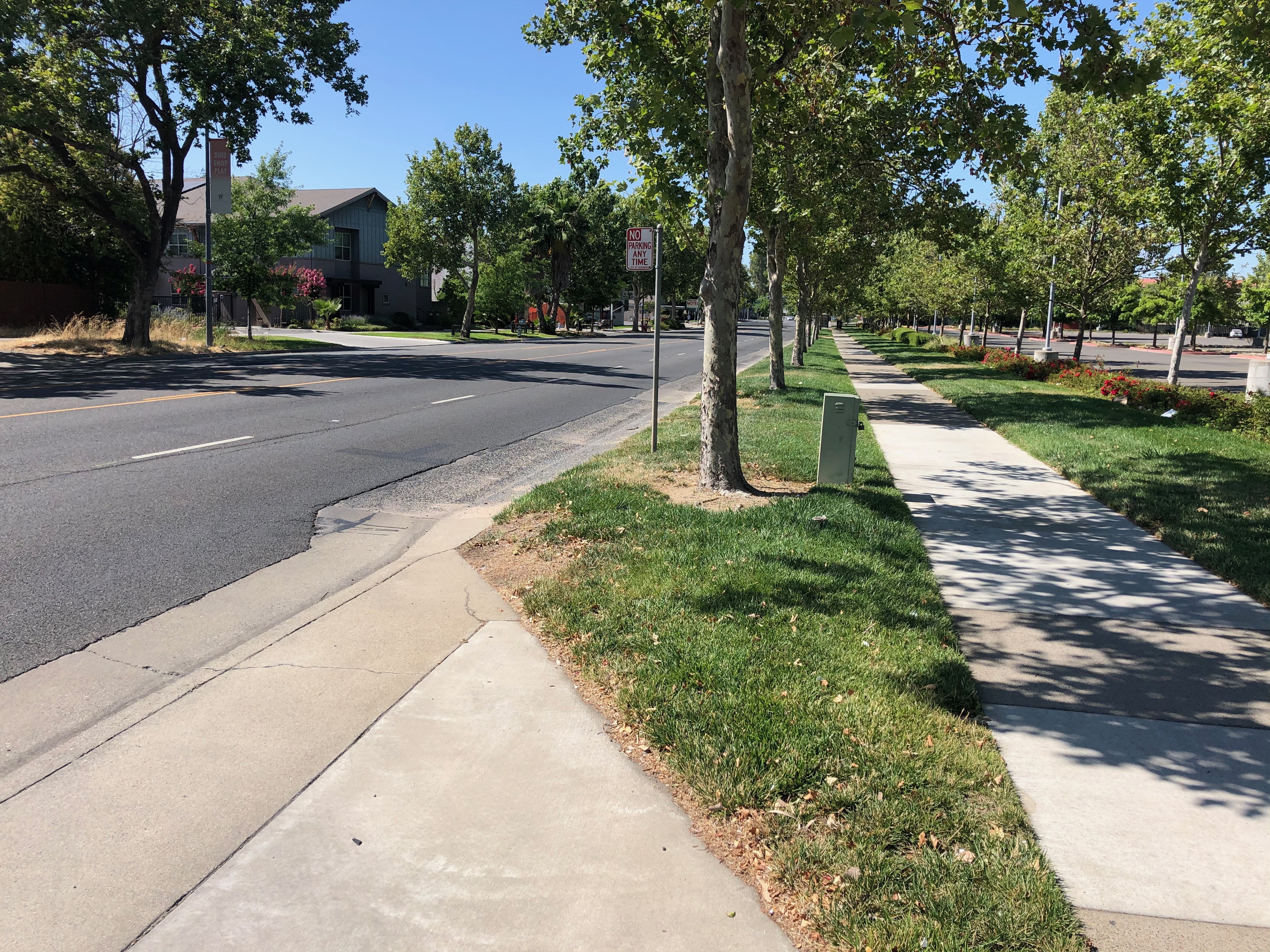
The photo below shows a section of Stockton Blvd with a sufficiently wide buffer (wider would be better), and healthy trees (at least until they mature). But this is an unusual section of Stockton. Much of Stockton has narrow sidewalks and no sidewalk buffers. The city is planning to spend a lot of money on reconfiguring the roadway on Stockton, but is not fixing the sidewalks nor adding sidewalk buffers except in a few places.
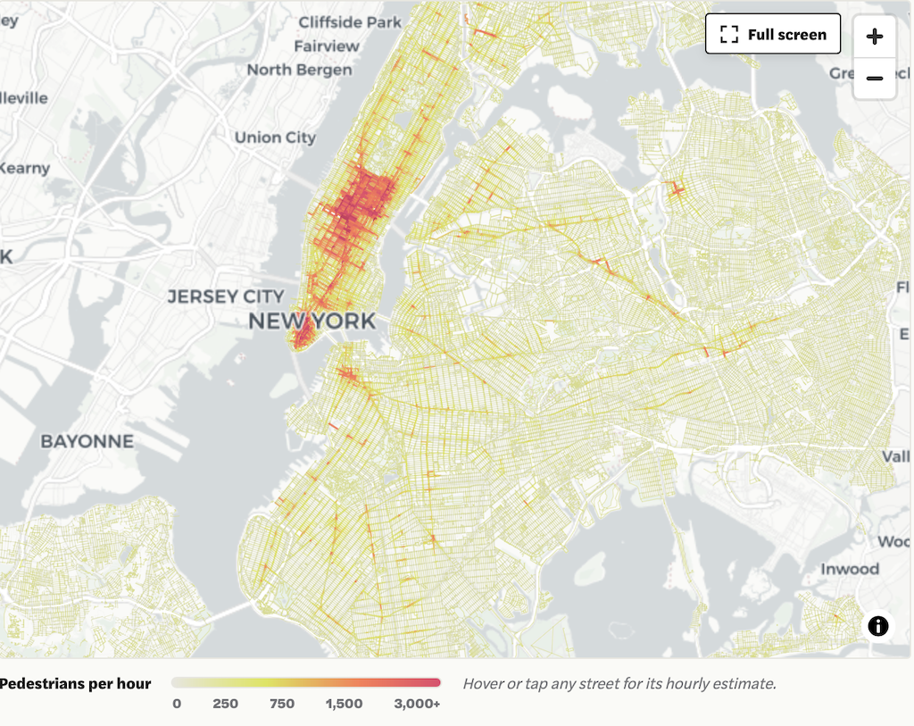
A recent article on the Vital City NYC website documents a program in New York City to not only document sidewalks, but how they are used by people walking. It was a cooperative project between MIT and the city. It is amazing what can happen when a city really pays attention to the needs of citizens who walk. Sacramento is not that city.
Of course Sacramento is nothing like Manhattan. A favorite saying of people who dislike change is that Sacramento is not New York. Or San Francisco. Or Portland. Or Paris. Or Amsterdam. Or any other city on the planet that has made progress on recognizing that people walking are the core of the city and city life. It is most certainly not any of those places people visit for its walkability. But parts of Sacramento are not dissimilar to the other boroughs of NYC, so I think this program is very indicative of what Sacramento could do, if it wanted to. If you look at the map in the article, scroll the map to the right, you will see the medium to low density boroughs.
I do travel to many places where the sidewalks are much worse than Sacramento. Looking at you, City of Los Angeles. Sacramento has decent sidewalks, where they exist, but there are sections of the city where they do not exist. And sidewalk buffers are lacking in most of the city, the topic of a future post.
The program started by documenting where the sidewalks and crosswalks are. Sacramento does not have information about where the sidewalks are and are not, where the painted crosswalks are and are not. I have done PRAs (Public Records request) for sidewalk data, and the city states that it does not exist. The fact is, some exists, but it is of low quality, and the city has apparently decided that it is better to deny existence. The Streets for People Active Transportation Plan did collect sidewalk data, but since the data has not been released to the public, it is unknown how comprehensive it is.
A good sidewalk inventory would include: presence or absence of sidewalks, width of sidewalk, presence or absence of sidewalk buffers (which the city calls planting strips) and the width of buffer, condition (deterioration, cracking, root heaves), and driveway crossings, whether flat or sloped. A crosswalk inventory would include the presence or absence of ADA ramps or ramps of any sort even if they are not PROWAG compliant, the crosswalk design (including width and length), and visibility of the crosswalk (visible or faded or non-existent).
The program then modeled sidewalk and crosswalk throughout the city, using existing studies of smaller typical areas and field counts. This is the most innovative part. That data can be used to estimate exposure, the number of people injured or killed, divided by the number of people walking. It is the measurement of rate, which is the best measure of anything related to transportation and in particular, traffic violence.
Where New Yorkers Walk, and When (MIT City Form Lab)
“Walking, after all, is not a niche activity. It is the connective tissue of urban life. It links transit to destinations, homes to neighborhoods, individuals to one another. It is also the most equitable mode of transportation we have. To take it seriously — to measure it with the same rigor we have long applied to driving — is to begin to see cities more clearly. And perhaps, in doing so, to design them more wisely.” – Andres Sevtsuk
Prior posts on this project, and previous permutations, are available at category: StocktonBlvd.
The City of Sacramento (and partners SacRT and Sacramento County are hosting a public workshop on Thursday, April 15, on the Stockton Blvd Safety and Transit Enhancement Project (STEP). The workshop will start 5:30 PM at the Oak Park Community Center, 3425 Martin Luther King Junior Boulevard, Sacramento, CA 95817. Registration is available (Eventbrite) but not required.
There will probably be a slide presentation, and display boards showing in some detail aspects of the project. These workshops offer the public sticky notes that can be placed on the display boards, and comment cards. If you’d like to see these ahead of time to ponder, or to visit specific sites, tough luck. The city doesn’t do that.
Though the project is about the entire SacRT Route 51, the highest ridership of the system and one of only a few high-frequency (15 minute) routes, the roadway changes would almost entirely be on Stockton Blvd.
The project has three main aspects:
Create a transit priority street for Stockton Blvd between Florin Road and Broadway, or perhaps T Street. This will be a bus rapid transit (BRT)-light facility, with dedicated bus lanes (red) in part, and improved bus stops.
Add bike lanes, usually buffered but not separated, to Stockton Blvd.
Add and improve pedestrian crossings of Stockton Blvd, which current has few safe crossings.
Two bus route alignments are being considered, the existing Route 51, and an alternative 2 that would continue on Stockton north of Broadway to T Street, thereby serving Aggie Square/UC Davis Medical Center.
What the project neglects is:
Wider sidewalks. These should be a minimum of 8 feet. Existing sidewalks are often 4 to 6 feet, and are curb-attached, immediately adjacent to motor vehicle danger.
Trees, and the wide sidewalk buffers (8 feet minimum) necessary to host healthy trees without root heaves that buckle sidewalks over time.
Though the project benefits include “More inviting public spaces with improved lighting and landscaping”, there are so far no details on what that means. Lighting is often ‘motor vehicle scale’ on tall standards and illuminating the roadway, not ‘pedestrian scale’ and illuminating the sidewalk for safety and aesthetics. Though there are a few locations in Sacramento with pedestrian scale lighting, these were installed by developers long ago when people walking were considered more important than people driving.
What are your thoughts? Concerns? Ideas? If you aren’t able to make the workshop, there is also a survey. The survey asks for your use and interest pattern, but is not intended to gather detailed feedback.