Walkable City book club: Step 5: Protect the Pedestrian

The Walkable City book club will meet again this Wednesday at Lefty’s Taproom, 5610 Elvas Ave, in east Sacramento, 6:00PM to about 7:30PM. If you can’t arrive at the beginning, or need to leave sooner, that is fine, your presence is welcome for whatever you can make. Though some of the people in the book club group are ‘walkable city’ advocates, there are also people who are simply interested in making Sacramento more walkable, and more safe. Everyone is an expert when it comes to identifying what aspects of our transportation system don’t work for them personally, and the others are happy to fill you in on what we call the problems and possible solutions to those problems. We also celebrate the walkable nature of some places in Sacramento. Though many of us live in the City of Sacramento, we also discuss areas throughout the region. So please join us!

Walkable City: How Downtown Can Save American, One Step at a Time, 10th Anniversary Edition, Jeff Speck. Sacramento County Library has one copy of the 10th edition, waitlisted, and one copy of the 2012 edition, available. It is of course also available from your local bookstore, though it may need to be ordered, and Amazon has Kindle, paper and hardback versions.

The Walkable City book club: Step 5: Protect the Pedestrian section has eight parts:

Read More »

Sac Vision Zero top ped intersections

As promised, a follow-on to my post on the top bicycle collision intersections in Sacramento (Sac Vision Zero Top 5 Corridors and top intersections), here is the same sort of analysis for pedestrian collisions. I used a somewhat different data set, this time only killed and severe injury crashes (KSI), for the years 2009-2017. This mirrors the data the city used in the Vision Zero Top 5 Corridors document, and so is not directly comparable to the different criteria I used on the bicycle post.

Pedestrian (walker) collisions are more dispersed that bicycle collisions, fewer occurring at intersections and more in between. Of the 408 collisions, 70 were at intersections, 17%, compared to 69% for bicycle collisions. Of these 408 collisions, twelve intersections stood out: Amherst St & Florin Rd, Marysville Blvd & Grand Ave, and Watt Ave & Auburn Blvd, each with three; and 15th St & Capitol Mall, 29th St & Florin Rd, 5th St & N St, 7th St & J St, Stockton Blvd & Broadway, Stockton Blvd & Lemon Hill Ave, Riverside Dr & X St, and Julliard Dr & Kiefer Blvd & Folsom Blvd, each with two. Of these 12 intersections, 4 are on Top Five corridors: Marysville Blvd & Grand Ave on the Marysville corridor, Stockton Blvd & Broadway on the Stockton-Broadway corridor, Stockton Blvd & Lemon Hill Ave on the South Stockton corridor, and 29th St & Florin Rd on the Florin corridor.

The map belows shows the city corridors and the twelve intersections, with the number of collisions and intersection name labeled. There is also a pdf available.

map Vision Zero top pedestrian intersections
Sacramento pedestrian collision top intersections, with Vision Zero corridors

There is a better alignment between the five designated corridors and pedestrian collision intersections than was true for bicycle collisions.

I will point out that the Julliard Dr & Kiefer Blvd & Folsom Blvd intersection is the site of three pedestrian collisions and four bicycle collisions, which is higher than any other intersection in the city. It should really be a focus for the city.

Addition 2021-03-02: Someone asked how the pedestrian collision locations relate to disadvantaged communities. Below, a map with CalEnviroScreen 3 2018-06 (CES) layer, with red end being higher pollution, green being lower, and weighted with income. CES is not the only measure of disadvantage, but it is one commonly used.

Walkable Sacramento #7: barriers

There are two major kinds of barriers to walking in the city, natural barriers such as the two rivers, and constructed barriers such as the freeways. Fixing either kind will be quite expensive. I am in favor of pedestrian and bicyclist bridges, perhaps with transit if appropriate, but not motor vehicles. Though a small increase in the number of road crossings is needed, most of these are outside the city in the county.

Policies:

  • Construct safe pedestrian and bicyclist over-crossings of freeways, and rail lines without street-level crossings, at an interval of no less than one-quarter mile, to improve circulation. Work with Caltrans, railroads, and the legislature to ensure that the expense is shared and not the sole responsibility of city taxpayers. Complete within ten years. 
  • Consider safe pedestrian and bicyclist crossings of the rivers (Sacramento and American) at an interval of no less than one-half mile, to improve circulation. Complete within 15 years.
R Street bike bridge over I-5

Walkable Sacramento

With the creation of specific goals and implementation of specific policies, the City of Sacramento can become a walking-first city, in the same sense that San Francisco and Chicago are transit-first cities. 

These goals transcend the built form; they are as applicable to the suburbs as to the central city. Though the policies are in part an attempt to regenerate the suburbs that were built on a cars-first model, they are applicable everywhere in the city. 

Accomplishment of a walkable Sacramento will require that most transportation funding over the next ten years be directed to fixing pedestrian infrastructure that was poorly designed without the needs of walkers in mind. In all policy, investment, and expenditure decisions, the needs of car-free and car-light individuals and families will be considered at least co-equal with those of drivers. Much of current transportation infrastructure was created without considering those too young to drive or too old to drive safely, and who cannot or choose not to drive. A walking-first Sacramento requires that we invert this model, with walkers the top priority. 

Low income communities should receive the first improvements to the walking environment, to counteract previous disinvestment and higher traffic threats in these communities. Neighborhoods with both low-income and high walking rates will be prioritized. However, at the completion of changes in policy and infrastructure, all neighborhoods will be walkable.

Reduction of greenhouse gas emissions, which requires a reduction in vehicle miles traveled, and public health benefits for physical activity, air quality, and protection from traffic hazards, will be the primary motivators of a shift to a walkable Sacramento. These and other benefits will be clearly communicated to the public to create and maintain support for the necessary changes. It is recognized that the changes necessary may make travel by privately owned vehicle somewhat slower and less convenient, but the emphasis will be on the ways in which walking is superior to driving for many trips. 

The goal of our transportation system for walkers will be zero serious injuries and fatalities, and any policy or practice that does not support this goal will be eliminated. 

Goals

  • Everyday destinations such as jobs, groceries, coffee shops and schools will be available within a 30 minute walk of every residence.
  • Walking, bicycling and transit infrastructure will be planned together so that they support each other synergistically.
  • Walking will be an option for most trips in life, and will be the preferred mode for many trips.
  • Pedestrian infrastructure will receive the majority of transportation funding until such time as it is complete and in a state of good repair.

Note: This is part one of a series of posts. I’m breaking it up both for my benefit and in the hopes that it will encourage people to comment on specific categories and issues and not just the concept as a whole. More to come…

Legislation I’d like to see

In all my spare time, which means while commuting to work on my bike, I think about state legislation I’d like to see. Here is my list of the moment. Feel free to add suggestions.

Bicycling

  • Remove far-to-the-right bike lane provisions, CVC 21202
  • Flip parking in bike lanes from permissible unless posted to prohibited unless posted
  • Require that all signals detect bicycles within two years
  • Be explicit in CVC that placing waste containers in bike lanes is the same violation as leaving any material in a travel lane
  • Require that all waste containers be inscribed with ‘do not place in bike lane’, and have reflective stripes on the sides of the container
  • Implement ‘Idaho stop law’ (yield as stop) for stop sign controlled intersections

Pedestrians

  • Require full traffic studies for the removal or crosswalks or prohibition of crossing, with the default position being that crosswalks will not be removed and prohibitions will not be created or continued
  • Remove the prohibition on pedestrians crossing the street between signalized intersections on all streets 30 mph or less

Speed

  • Change the prima facie speed limit for residential and commercial streets (local) from 25 mph to 20 mph; change to 20 mph or less for posted school zones
  • Set the maximum speed allowable on collector streets to 30 mph; set the maximum allowable speed on arterial streets to 40 mph
  • Allow automated speed enforcement everywhere

Schools

  • Require law enforcement to send incident reports involving children going to or from school to school districts within 24 hours of completion, and investigations within 72 hours of completion
  • Prohibit U-turns within school zones
  • K-12 school districts and colleges/university would be required to have transportation demand management programs, since school-related traffic is a significant portion or overall traffic

Other

  • Shift the burden of proof to the motor vehicle driver for all collisions with pedestrians and bicyclists involving fatality or severe injury
  • Allow any citizen to challenge the professional license of an engineer who is aware of a traffic safety hazard and fails to request funding to mitigate that hazard
  • Decriminalize transit fare evasion
  • Allow conversion of any and all freeway lanes to toll

Curb extensions 16th & N

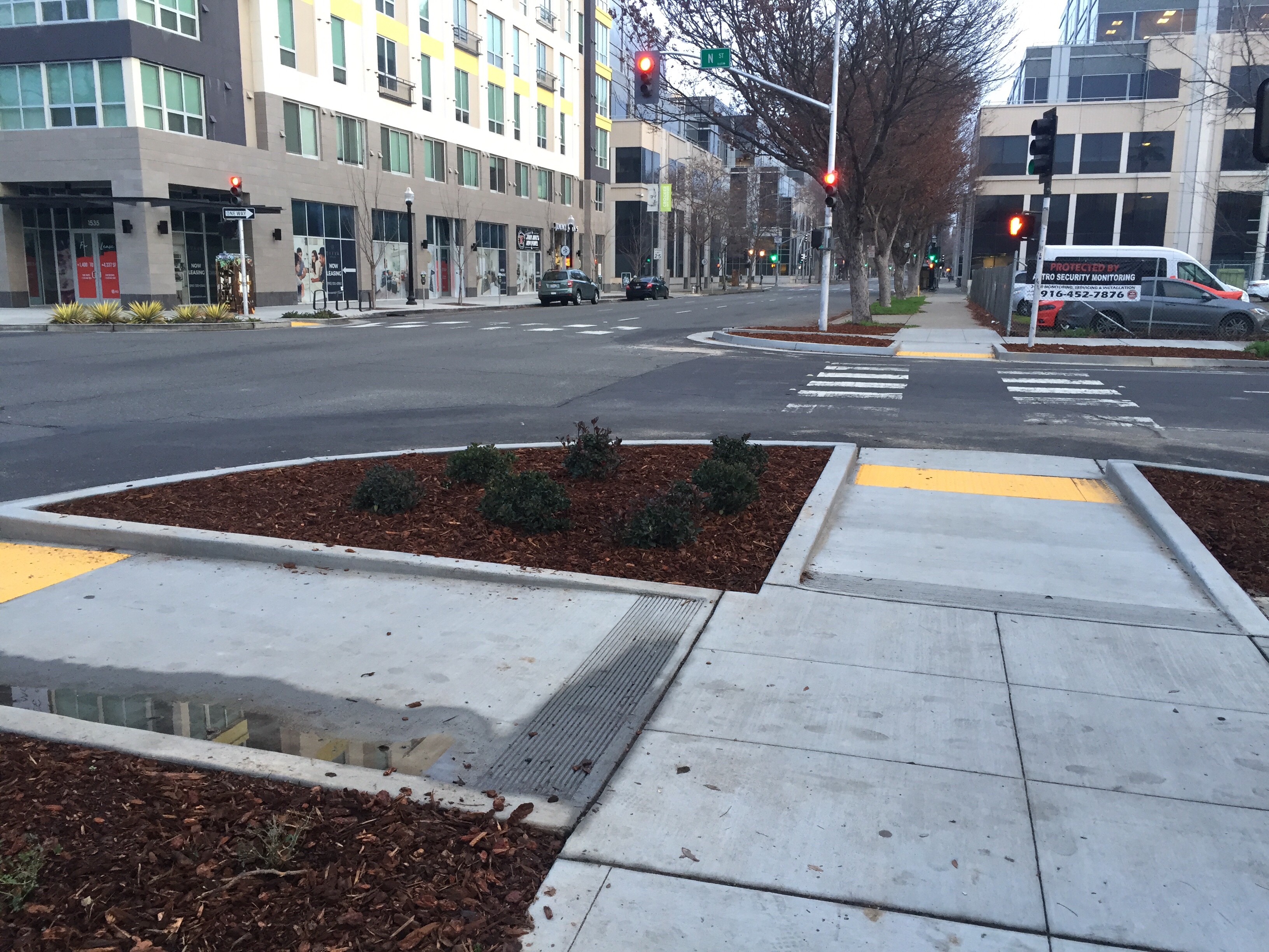
Curb extensions, also called bulb-outs, have been installed on all four corners at the intersection of 16th Street and N Street in midtown Sacramento. The extensions are the width of the parking lanes along both these streets. N Street has bikes lanes, which are not restricted by the extensions, while 16th Street does not have bike lanes, and won’t until the street is reconstructed into a more complete street at some unknown point in the future.

The primary beneficiaries of curb extensions are pedestrians, who have a shorter distance to cross, with every crossing being about six feet less distance for every parking lane, so in this case, 12 feet less. There is also much better visibility of cars by walkers, and of walkers by car drivers. Sometimes they also provide an opportunity for beautification, with rainwater swales and/or planting, as can be seen in the photo.

Every street with parking lanes should have curb extensions, so almost every intersection, but implementation will be slow because they are moderately expensive to construct (curbs sidewalks, detectable warning strips, better located ped buttons), and sometimes require drainage changes and occasionally even utility relocation. These particular extensions are certainly not the first in Sacramento, in fact there are extensions on the west corners of the intersection of 16th and O, just to the south, but are notable for being installed in a high pedestrian use area along two heavily trafficked streets.

Distracted walkers are not the problem

It has become popular recently to blame pedestrians for their own death. Some have always done this, from the beginning of the auto industry and its “jaywalking” campaign, but it is amazing how much law enforcement promotes this blame, how much the media buys into it, and how much transportation and safety agencies (Caltrans and OTS) market it. 

So let me share my experience. I walk, a lot, in addition to bicycling, a lot. Every day drivers refuse to yield my right of way when I am making legal street crossings. It makes little difference if I am waiting on the curb (where they are not required to yield, except by common courtesy), or waiting in the street, where they are absolutely required to yield to me. On multi-lane streets, when one driver stops for me, it is quite common for drivers in other lanes to not stop, though the law requires them to. I am never walking distracted, I make the personal choice to not look at my phone while crossing the street. But for anyone to suggest that it is the fault of someone walking distracted when a driver fails to yield right of way to a pedestrian, and kills them, is deeply, deeply offensive. This is similar to someone saying, well, I was just firing my gun and someone happened to walk in front of it. Cars are deadly weapons, and drivers are potential killers. It is time our society grew up and took responsibility for the harm that can be caused, and is caused, by our addiction to driving, and to the imputed freedom to run down someone who is just crossing the street. 

Sac Grid 2.0 additions

The Sac Grid 2.0 plan is a good one which I mostly support, but I have had, and do, and will have, some suggestions that I think would improved it.

Access to and from the Sacramento Valley Station (Amtrak) is of critical importance for walkers, bicyclists, and transit users. Bicycling and walking are handicapped by the one-way streets, high-volume and high-speed streets, and prohibited pedestrian crossings. It is not clear from the maps presented, and the projects may not have been clearly enough defined, to know whether these issues will be completely or only partially solved by the Sac Grid 2.0 plan and resulting projects. Two key issues are: 1) exactly how I Street will be modified to improve access, and 2) whether access will be provided to the train platforms from the Class IV separated bikeway through the railyards that connects F Street in the east to Jibboom St and the Sacramento River Bike Trail on the west.

There are locations where pedestrian space is already so constrained and pedestrian use is so high that some roadway must be reallocated to sidewalks. Two examples are 16th Street between P and O Streets on the east side, where the restaurant seating leaves far to little pedestrian space, and J Street between 21st and 22nd Streets on the north side, with the same issue. As more and more properties are redeveloped and the pedestrian realm activated along 16th Street and J Street, these issues will become more profound. The city is already proposing some reallocation in both these locations, but I am concerned that the reallocation will be to bicyclists and not to pedestrians. Despite myself being primarily a bicyclist, I believe that pedestrians are more important than bicyclists to making a place livable, walkable, and economically successful. So I hope that in cases where a limited amount of road space must be reallocated to one or the other, pedestrians will receive preference.

The Chicago complete streets mode priority diagram, which I’ve shared before, visually summarizes my feelings about transportation in the grid, and beyond. I’d like to see the city adopt this diagram to express priorities. I know some in the bicyclist advocacy community would like to see bicycle in position one or two, but I think the indicated priorities will lead to the most livable place, and therefore the happiest environment for everyone.

ChicagoCompleteStreets

The city has said that the element maps will be posted to the Sac Grid website soon, and when that happens, I can point out some additional areas of concern.

no-ped-crossing in the grid

no pedestrian crossing means three crossings

As mentioned in my recommendations for improving walkability in midtown/downtown, in response to the Sacramento Grid 2.0 program, I’ve developed more information including a map (at bottom) about the locations in the grid that are signed against pedestrian crossing. The signs at these locations may be the modern MUTCD R9-3a sign, shown at right, or the older text sign, shown below, or variety of non-standard signs. Update 2015-07-27: 37 locations.

5th-St-I-St_no-ped-crossingThere are a large number of other locations where crossing is discouraged by the lack of sidewalks, curb ramps, and crosswalks, but is not specifically prohibited.

As can be seen from the map below, the majority of the no pedestrian crossing locations are along the Capitol Expressway (Business 80) and US 50 freeways. These freeways, designed and constructed by Caltrans, are barriers to pedestrian use. In fact, they are a barrier to all use and livability because many of the grid streets do no continue under the freeways, making access more difficult for pedestrians, bicyclists, and motor vehicle drivers. In many cases there are no sidewalks on the freeway side of the adjacent surface street, so whether or not there is a safe or marked crossing doesn’t mean much without a sidewalk to connect to.

Read More »

Sacramento has stalled

Jim Brown wrote recently in the Sacramento Bee about underfunding for the city’s contractor to develop a new bike plan, and the plateauing of progress on bike mode share in the city. Please read! However, the issues go well beyond bicycling. Sacramento has stalled, period. We are no longer making forward progress towards livability.

There are three additional major issues, as I see them:

  1. Our public transportation system (SacRT) is woefully underfunded, and despite a lot of discussions recently about how to improve the system, not one of our political leaders seems to have the courage to state the obvious, that we cannot have a successful and efficient system unless we devote more tax revenue to it. Putting bandaids on the system will not make a significant difference. Sacramento needs to fund SacRT at a level comparable to other cities of our size, which means tripling our tax base.
  2. Sacramento is not becoming more pedestrian friendly, in fact it seems to me to be becoming less so. There is an almost universal failure among drivers to recognize the rights of pedestrians to cross the roadway (CVC 21950). I find that almost no drivers yield to me when I am walking. Apparently the Sacramento Police Department accepts this situation, because so far as I know they make no effort to enforce the law. I have never seen someone pulled over for failing to yield to a pedestrian, and in fact I’ve had several SacPD officers fail to yield to me. Pedestrians, not bicyclists, are the indicator species for our city, and until we treat people walking as the highest form of transportation, we will never be anything but a sad city. [As an addendum to this, Chris Morfas reminded me that the conversion of one-ways streets to two-way streets has also stalled. The city made a decision to start these conversions years ago, and then lost courage. Nothing has happened on this critical change in years.]
  3. The city is going to focus much of its attention on Natomas, now that the building moratorium has been removed. I think that no effort and no money should be spent there until the city develops a new vision for Natomas. The sprawl suburbs are a dead end, and we should not be spending any money on them until we have a plan for how to make them financial viable and livable. Meanwhile, the two truly needy parts of the city, South Sacramento and North Sacramento/South Natomas, are neglected. These are the areas where the most people are walking, bicycling, and using public transit, but yet the city continues to throw money at the “rich” areas that it hopes will provide sales tax and property tax revenue to save the city from its debt problem. The fact is, however, that it always costs more in infrastructure to support new developments than they ever generate in sales and property taxes. It is the small businesses in South and North Sacramento that actually support this city.

There is also much to celebrate in Sacramento. I live in midtown, and I am so impressed with the new development happening, with the richness of opportunity here, and even impressed with the improvements to bicycle facilities that have happened. But most of this is driven by economics, and will happen with or without the help of the city. What won’t happen without the help of the city is livability in South and North Sacramento. Indeed, to say something controversial, I think the city needs to pay way less attention to downtown/midtown, and much more to the neglected areas north and south. I am not saying that every area of the city can be saved – we will have to prioritize and triage – but to keep acting as though downtown/midtown are the whole of Sacramento indicates a complete lack of leadership on the part of the city council.