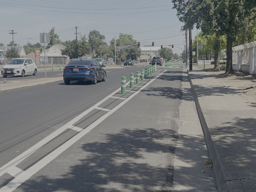
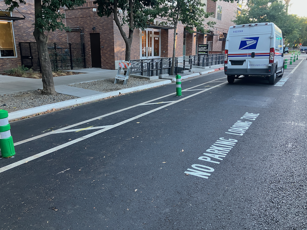
Northbound, the project starts just beyond Los Robles Blvd, and ends at Grand Avenue. Southbound, the project starts just beyond Harris Avenue, and ends just beyond Nogales Street. The focus of the project is narrowing the roadway from four lanes to two lanes with adjacent bike lanes or separated bikeways. Some bicycle facilities are just paint on the ground, while some stretches use vertical delineator (both green K-71 and white ‘wands’ with bases). A typical section is below. The bike lanes at the north and south ends are of poor quality, depending on the gutter pan with a strong linear seam to achieve minimum width. In the middle section, the quality varies but is mostly acceptable.
Marysville Blvd northbound, north of Rosalind St, separated bikeway with K-71 delineators
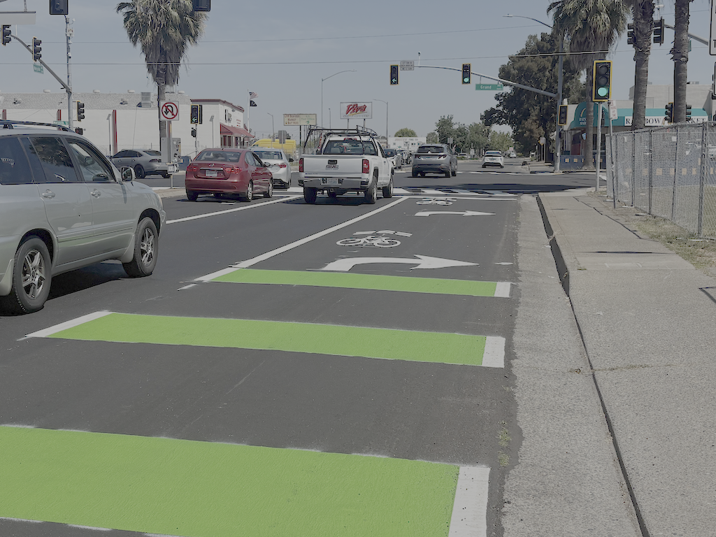
The project uses shared bike lane/turn lane areas at Grand Avenue, below. This is not the worst design, placing bike lanes to the right of right-turning vehicles, but neither will it be comfortable for many bicyclists.
Marysville Blvd northbound at Grand Ave, shared bike lane and right turn lane
Observing motor vehicle traffic on a Saturday, it appears that drivers have adjusted to the change. Though the varying treatment of the right-of-way might be confusing, it seems to be handled OK. The only issue is that a police motorcycle used the bike lane to bypass traffic, and almost hit me. I did not see anyone bicycling along Marysville, though I did see a number of bicyclists crossing Marysville at side streets.
The signal faces at Marysville Blvd and Grand Avenue were replaced. Other signals were not changed, so far as I can determine. One of the signal faces for Marysville northbound at Grand is out, probably due to mis-wiring.
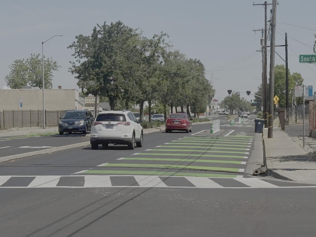
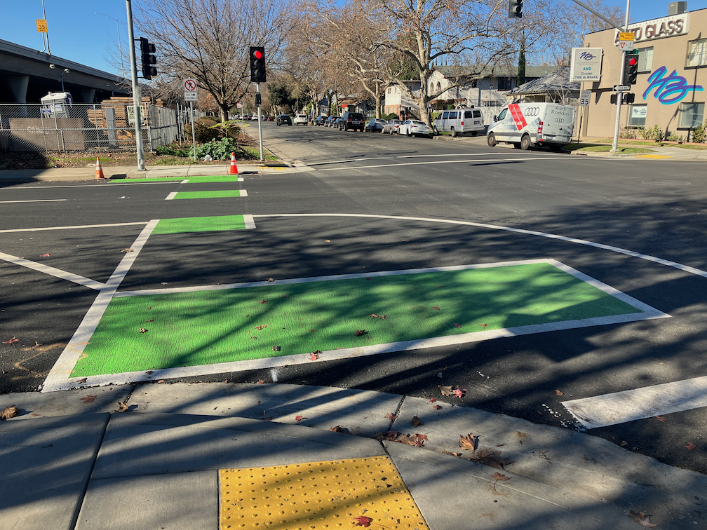
SacRT bus Route 86 runs on this section of Marysville Blvd. Bus stops were marked with dashed (skip) green markings for sharing with bicyclists, below. I suspect the bus area is not long enough for bus use, but since I did not see an buses along the route today, I’m not sure. The bus only runs once per hour on Saturdays. I think the design is safe for bicyclists since it is such a clearly marked area. The only better design would be a bikeway behind (curb-side) from a bus boarding island, though with only one lane for motor vehicles, the city is very reluctant to have buses stop in traffic. I’ve got not problem with it, transit riders have no problem with it, but engineers just can’t stomach giving priority to buses.
Marysville Blvd shared bus and bike area
No improvements to sidewalks were made, not even corner curb ramps at the most critical intersection of Marysville Blvd and Grand Avenue.
This section of Marysville Blvd is characterized by:
moderate to poor sidewalk conditions and width
sidewalk cross-slopes at nearly every driveway, which is a hazard for mobility devices and many walkers
abandoned business building, and abandoned parcels that may have once been occupied by businesses or residences
an excess for driveways, most of are not in use; a number of the parcels have two or more abandoned driveways; even the City of Sacramento Hagginwood Park has an abandoned driveway
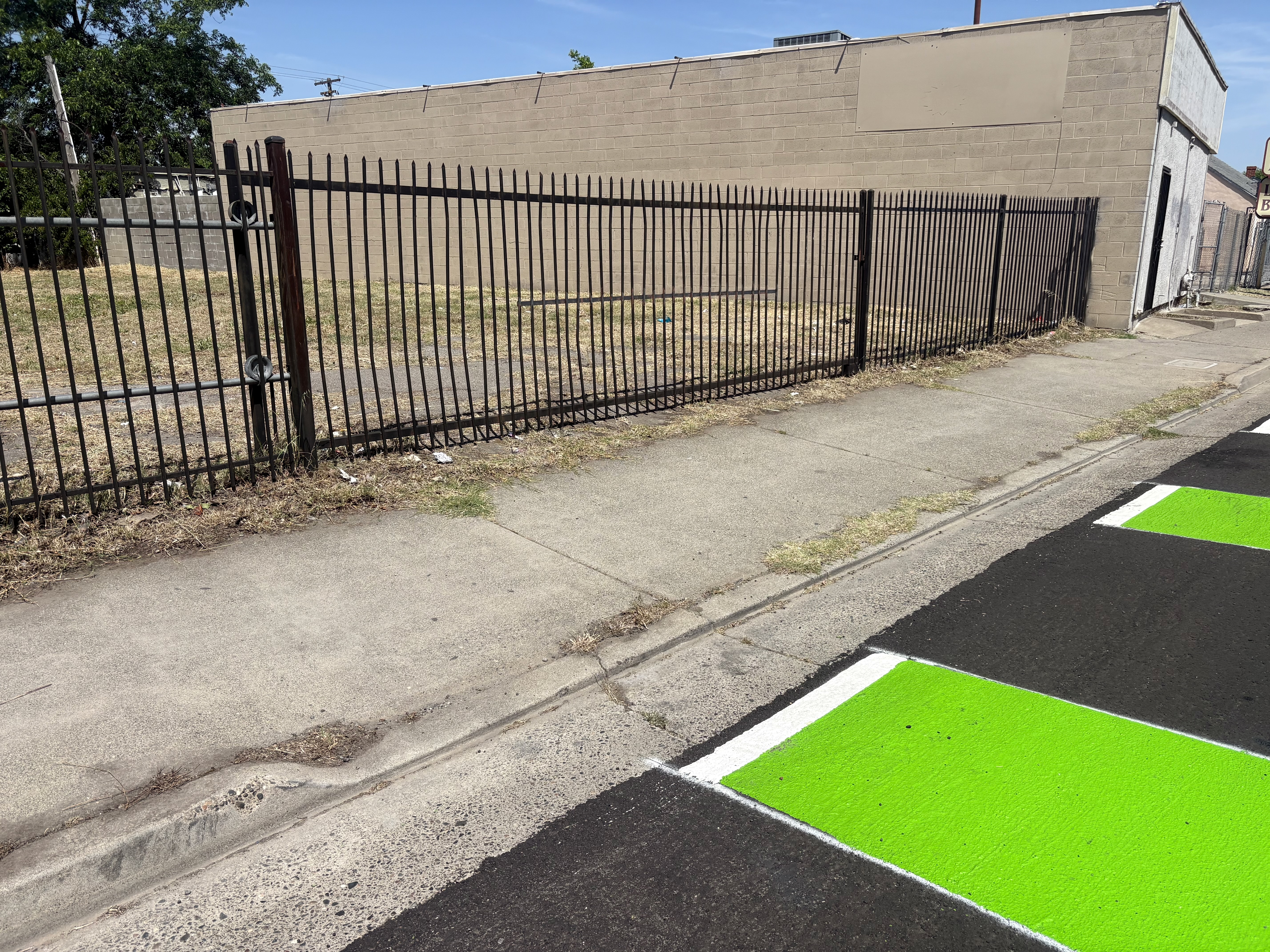
One example of a driveway that slopes across the sidewalk is below. There are dozens of locations just in this section of Marysville, to say nothing of north and south of the project. Some are active driveways for commercial buildings and residences, but probably at least one-third are abandoned, serving no purpose whatsoever except to make the walking/rolling experience less pleasant and more dangerous.
3617 Marysville Blvd, abandoned driveway with cross-sidewalk slope
The project has done nothing to improve the walkability of Marysville Blvd.
The signal which seems to be most confusing to walkers and drivers is the partial signal at Los Robles Blvd on the east and Hagginwood Park on the west. It was not improved in any way. Drivers are unclear about the signal, and so are not sure whether to yield to walkers in the two crosswalks.
I will have at least one more post on Phase 2 of the project, which is not fully funded and has not started.
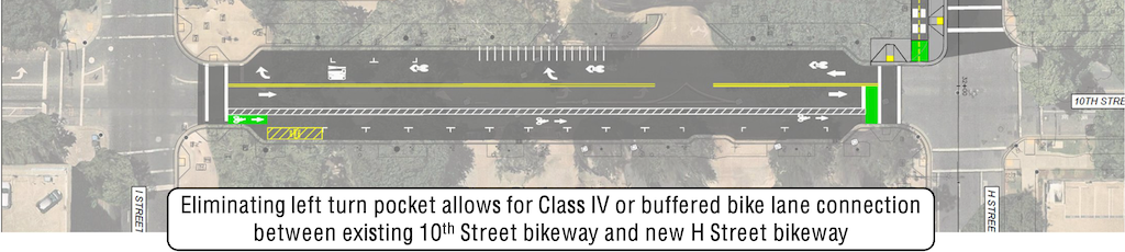
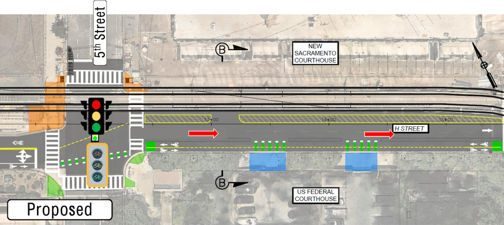
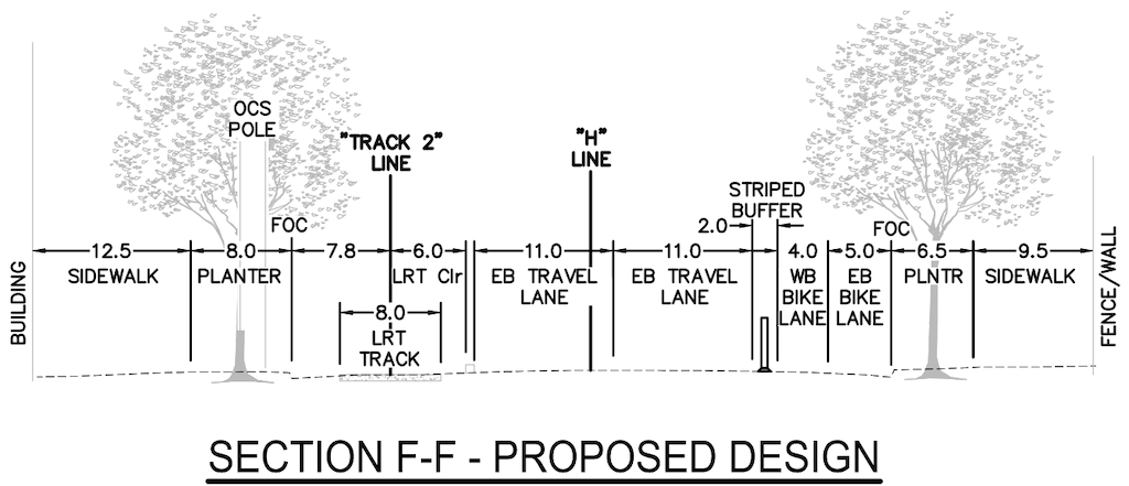
The 30% design for the 10th Street connection to the H Street Bikeway is shown below (these were also in the overview post H Street Bikeway: overview). The overall width of the roadway is 105.5 feet, and the ‘FOC face of curb’ width is 50 feet. The street narrows to 34 feet at the curb extensions at I Street and H Street.
H St Bikeway 10th St section, proposed (from SacATC presentation)H St Bikeway, 10th St section, proposed, 105.5 feet (from SacATC staff report)
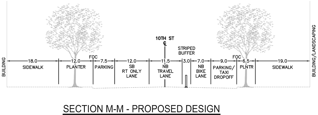
I have created a StreetMix cross-section duplicating the design cross-section so that it can be compared to an alternative recommendation.
H St Bikeway, 10th St cross-section, proposed (StreetMix created by Dan Allison)
The design proposes a 7 foot bike lane northbound, with a 3 foot stripped buffer, and a parking lane to the right against the curb. Despite the cross-section showing a vertical delineator in the buffer, this is not possible with a parking lane to the right of the bike lane. The bike lane continues the separated, mostly parking-protected, bikeway from the south, which is a good thing. But a buffered bike lane is less safe than a separated bike lane, so detracts from the safety and low-stress goals of the project. The design encourages drivers, whether parking or drop-off/pick-up, to cross the bike lane, a poor practice.
Instead, the design should create a parking-protected separated bikeway. This reduces the utility for drop-off/pick-up, but an larger area could be set aside in the parking lane for this purpose, and the conflict zone crossing the bikeway can be clearly marked. Bikeways that swing into the curb past curb extension, and out again past curb extension, feel awkward for bicyclists, but they have been installed in several locations along the separated bikeway network, and don’t seem to engender safety issues.
The design also proposes sharrows within a southbound general purpose lane. You will have to look closely at the image to see the sharrows, but there are there. They are placed far to the right, in the door zone. This is a very poor design. New sharrows should not be installed, as they don’t decrease crash risk over unmarked routes. If they were there, they should be placed in the exact middle of the travel lane, and supplemented by ‘bicycles allowed use of full lane’ signing (MUTCD R9-20). to make is clear that drivers should not be passing bicyclists in this block. It is particularly likely that drivers will squeeze out bicyclists against the curb extension at I Street. An alternative is to stripe a narrow 5 foot bike lane, without buffer or protection, marked with green. Not ideal, but better than sharrows.
The design retains existing parking. Though it is not clear that removing parking would allow a better design, this should always be a consideration. There is ample and never-full parking in the city garage on the south side of I Street between 11th and 10th Streets. The curb extensions at I Street and H Street are critical features for the safety of walkers, but they do constrain design in this block.
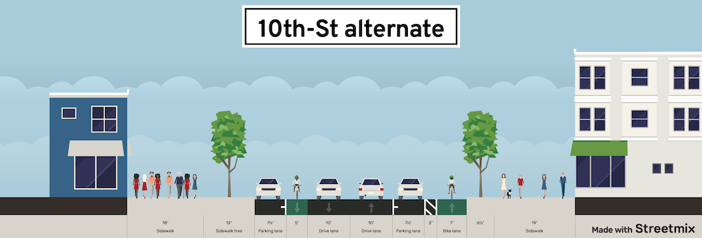
My suggested design is below.
H St Bikeway, 10th St cross-section, alternative design (StreetMix created by Dan Allison)
I do not have the time it would take to create an image of the street with the new design, but I think the cross-section will communicate clearly enough.
What is different? A southbound traditional bike lane (Class II) has been added. Both general purpose lanes have been reduced to 10 feet. There is no reason for over-wide lanes in this section. No buses, no delivery. The east side parking lane, an over-generous 9 feet, has been reduced to 7.5 feet. And the parking-protected separated bikeway is up against the curb, still with a 3 foot buffer from parked cars.
The H Street Bikeway project extends from 5th Street to 10th Street along H Street, and along 10th Street from I Street to H Street. It is intended to improve transit connectivity by double-tracking two blocks of light rail between 5th Street and 7th Street, and to improve bicycle access by providing a two-way separated bikeway (cycle-track) on H Street, which links to bikeways or bike lanes on 9th Street (southbound) and 10th Street (northbound). The project provides a reasonable solution, though it could be improved in a number of details (see H Street Bikeway: overview).
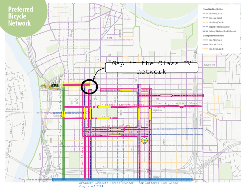
A map in the SacATC presentation shows the bikeway network in the central city, highlighting the gap on 10th Street from I Street to H Street.
Preferred Bicycle Network, showing gap on 10th St between I St and H St (from SacATC presentation)
It does not highlight the glaring gap on I Street between 12th Street and 10th Street. The separated, parking-protected bikeway on I Street, that starts at 21st Street, ends at 12th Street (it is just a bike lane in front of the fire department just west of 13th Street, but resumes further west).
For a bicyclist wanting to access the proposed two-way separated bikeway on H Street, they must use regular Class II (paint only) bike lanes from 12th Street to 10th Street, then proceed north one block in a buffered bike lane to H Street. I Street between 12th Street and 10th Street is three general purpose lanes. As it typical of any three-lane one-way street, motor vehicle speeds are well above the posted speed limit of 25 mph, except when congested. By the way, it is not posted at all in this section, though the change from two lanes to three lanes at 12th Street would make posting logical if not imperative.
There are other gaps, including 9th Street south of Q Street, and L Street and N Street. The map refers to a L & N Street Bikeways Project, but neither the planning or engineering sections of Public Works seem to have a webpage on that project. Strangely, the streets adjacent to Capitol Park are shown as Class II, paint only bike lanes, though these two sections without mid-block driveways are the most logical place for separated bikeways in the entire city.
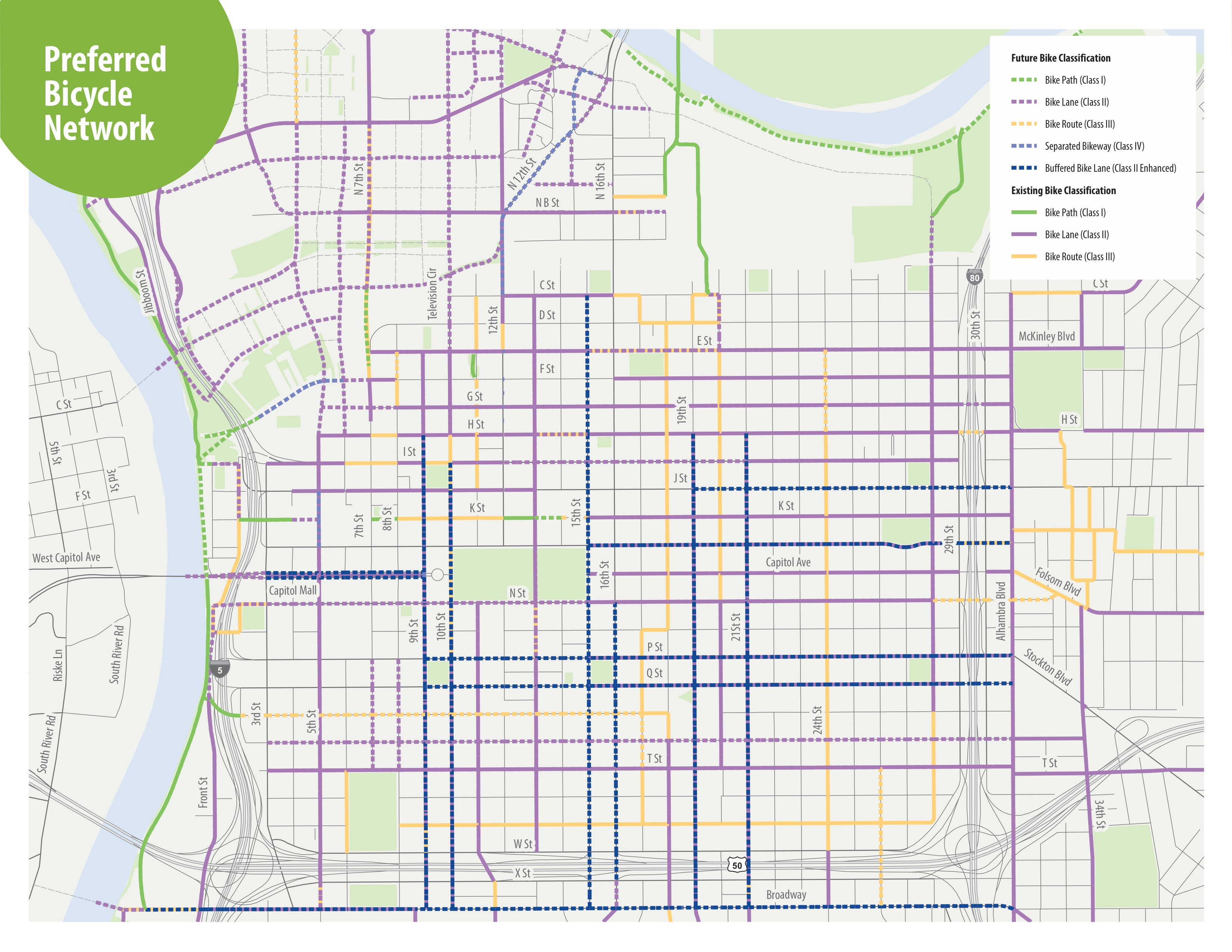
The map from the H Street Bikeway project presentation at SacATC was adapted from an old Grid 3.0 map (2016), below.
Grid 3.0 map of central city preferred bicycle network
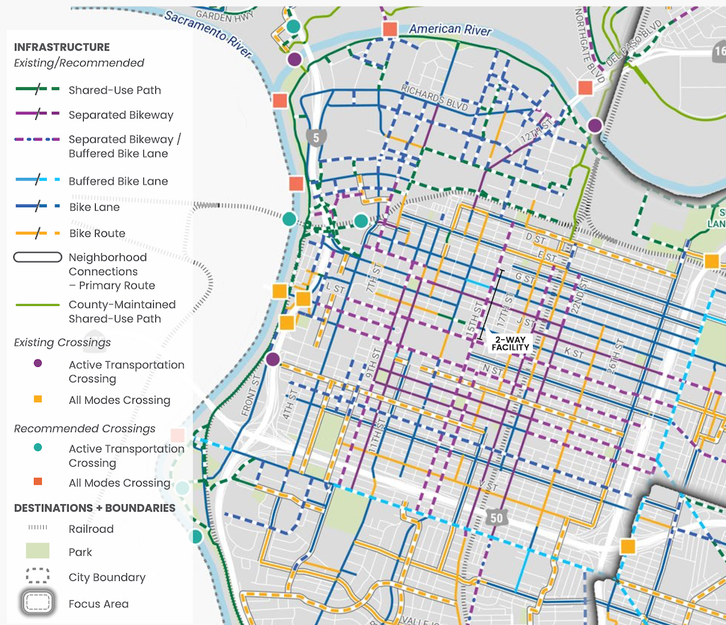
A more up-to-date map, with legend, is in the Streets for People Active Transportation Plan, page 80, ‘Figure 30 – Recommendations for People Biking in Central West Sacramento’, excerpted below. This map shows a separated bikeway (purple) continuing from 21st Street to 9th Street.
Update: Edited to add more accurate segments and cross-sections, make additional comments on design, make clear that the 6th-7th cross-section should be similar to the 5th-6th cross-section, with light rail tracks in their own right-of-way rather than the southern one (Line 1) being in a shared or mixed use lane with private motor vehicles.
Note: I realized last night in thinking about H Street that I had accepted too much of the city’s compromise to prioritize motor vehicle traffic and preserve parking. This section of H Street could be a model for how to do streets right, but the 30% design presented is not that. I’ve changed some recommendations and reorganized the post content.
Key points:
Mixed use transit lanes prioritize motor vehicle traffic over transit safety and efficiency. The mixed use lane between 6th Street and 7th Street must be changed to a dedicated transit lane.
The two-way bikeway must be a minimum of 10 feet in width (5 feet each direction) in order to provide safety, usability, and maintainability. This will require changing parking and/or general purpose lanes widths.
Two-way bikeways must have bicycle signals at every intersection. This design does not.
Where there are two general purpose travel lanes in same direction, as between 9th Street and 10th Street, only one lane needs to be 11 feet, while the other must not be more than 10 feet. This is generous, as most modern recommendations are between 9 and 10 feet. The safety advantages of narrower lanes are well documented.
Maintenance of on-street parking is clearly a priority in this design. While on-street parking can slow traffic, and is appropriate in retail and residential areas, here it is for the convenience of workers who could park in the ample parking garages and lots along and near H Street. Where roadway width is needed for safe and high quality bikeways, on-street parking can and should be removed.
The H Street Bikeway to Sacramento Valley Station project is presenting at the SacATC meeting this week, Thursday, February 19, starting at 5:30 PM. A community workshop will be held Thursday, February 26, starting at 5:30 PM at city hall, room 1119. This project is part of a large grant-funded project (TIRCP – Transit and Intercity Rail Capital Program) to improve Sacramento Valley Station. H Street is the main access route from the station for bicyclists. There are no safe routes to the station, at this time.
The project will create a two-way separated bikeway (also called a cycle-track) on H Street between 5th Street (the station) and 10th Street and 9th Street with existing bicycle facilities.
For the segment images, I have used the SacATC presentation. For the segment cross-sections, I have used the diagrams from the SacATC staff report, as they include measurements, which are critical for determining the safety and usability of the bikeway. StreetMix diagrams usually include measurements, but the ones in the presentation do not.
Transit priority
The TIRCP grant of which this project is a small part, is intended to support transit use to and from Sacramento Valley Station, to ensure that the station is the effective transit and rail hub that the city, region, and state want.
I support the double-tracking of light rail in the segment between 5th Street and 7th Street. Single-track light rail segments create pinch points where one train may need to wait for another, slowing the entire light rail system. The diagrams also seem to indicate a crossover between 5th Street and 6th Street, which is valuable for routing trains when there are blockages.
Segments
Bicycle facilities within Sacramento Valley Station, west of 5th Street, are not part of this project. I have not seen any recent information on how bicyclist circulation will be handled within the station area.
5th Street to 6th Street
This segment is reasonably well designed but could be improved. Double-tracking of light rail removes a bottleneck for the Gold Line/Green Line.
H St Bikeway between 5th St and 6th St, proposed (from SacATC presentation)
The buffer between light rail and general purpose lane (7.2 feet), and the overly wide general purpose lane (13 feet), totaling 20.2 feet, waste roadway width that could be devoted to the two-way bikeway. A better allocation would be, from right to left, 12 foot bikeway, 3 foot mountable curb, 3 foot buffer, 11.2 feet general purpose lane, and 4 foot buffer.
H St Bikeway from 5th St to 6th St, proposed cross-section, 92.5 feet ROW?, 52.5 feet FOC (from SacATC staff report)
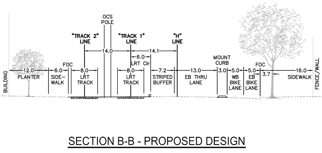
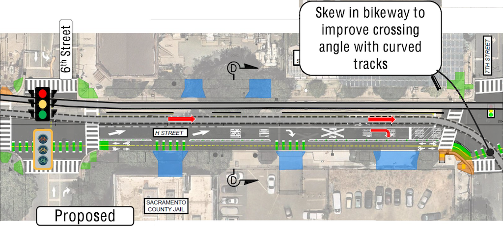
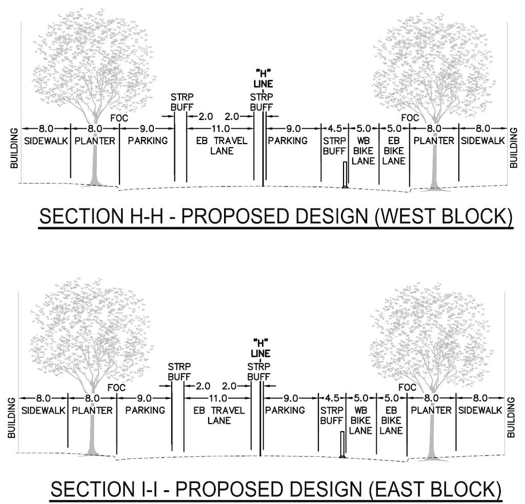
6th Street to 7th Street
The segment shows a light rail track sharing with motor vehicle traffic. This is inappropriate, and removes the advantage of double-tracking, since trains can be stuck in congested motor vehicle traffic. The southern or right hand lane should be a combined through and right turn lane, and the northern or left hand lane should be eliminated. The design constrains the bikeway to 4.5/4.75 feet, rather than the minimum of 10 feet. Diagrams below.
H St Bikeway from 6th St to 7th St, proposed (from SacATC presentation)H St Bikeway between 6th St and 7th St, proposed cross-section, 80.5 feet ROW?, 47.5 feet FOC (from SacATC staff report)
The 6th Street to 7th Street cross-section should be designed similarly to the 5th Street to 6th Street cross-section, shown below, with the suggested modifications to roadway allocation, as above in 5th Street to 6th Street segment.
H St Bikeway between 5th St and 6th St, proposed cross-section(from SacATC staff report)
7th Street to 8th Street
The preservation of parking in this segment is ridiculous. There is a parking garage of large capacity directly north across the street, so there is no reason for on-street parking here. The city’s desire to maintain parking in this section is in fact the reason why the existing Class III (sharrows only) bike facilitiy on H Street is dangerous and unpleasant. Again, retention of parking constrains the bikeway to 4.0/5.0 feet rather than the minimum 10 feet. Diagrams below.
H St Bikeway from 7th to 8th, proposed (from SacATC presentation)H St Bikeway from 7th St to 8th St, proposed cross-section, 83.3 feet ROW?, 48.6 feet FOC (from SacATC staff report)
8th Street to 9th Street
The segment design is reasonable.
H St Bikeway, 8th St to 9th St, proposed (from SacATC presentation)
However, since there are no driveways in this block, the separation between motor vehicles and bikeway should be a hard concrete curb, not a stripped buffer. The 10 foot bikeway is the minimum width, however, narrowing the parking lanes to 8 feet would provide space for a desired 12 foot bikeway.
H St Bikeway from 8th St to 9th St, proposed cross-section, 79.6 feet ROW?, 47.6 feet FOC (from SacATC staff report)
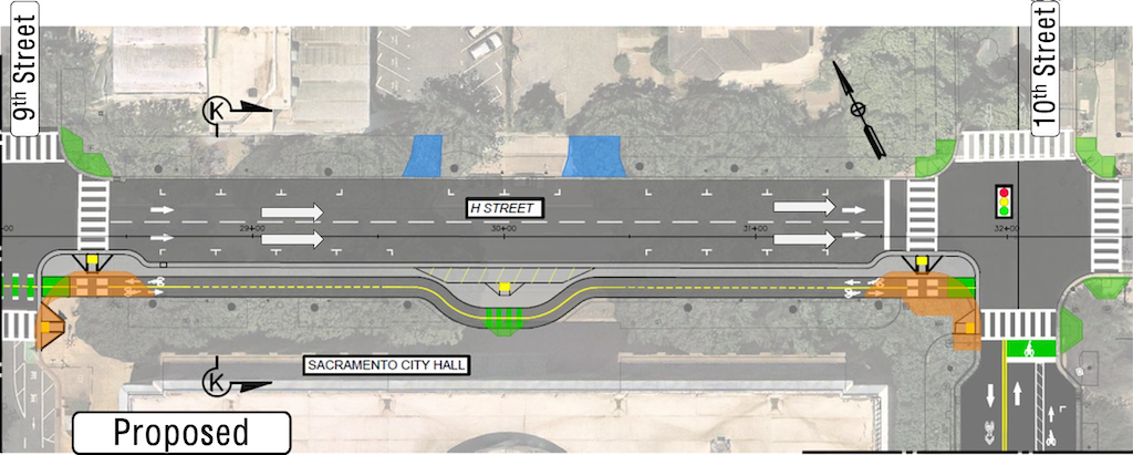
9th Street to 10th Street
I like the design of the segment, a sidewalk level completely separated bikeway.
H St Bikeway from 9th St to 10th St, proposed (from SacATC presentation)
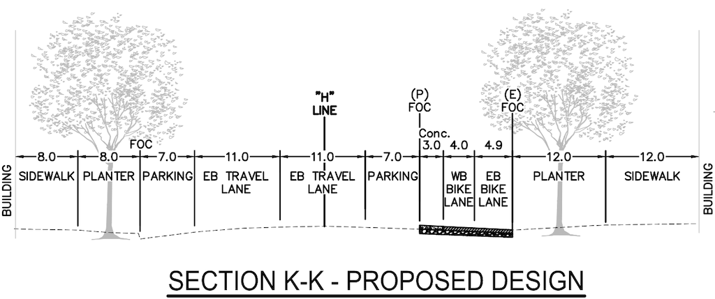
The width of the bikeway is 4.0/4.9 feet (8.9 feet) rather than the minimum of 10 feet. It is not clear how to reallocate roadway width to accomplish this, but it must be done.
H St Bikeway from 9th St to 10th St, proposed cross-section, 87.7 feet ROW?, 47.7 feet FOC (from SacATC staff report)
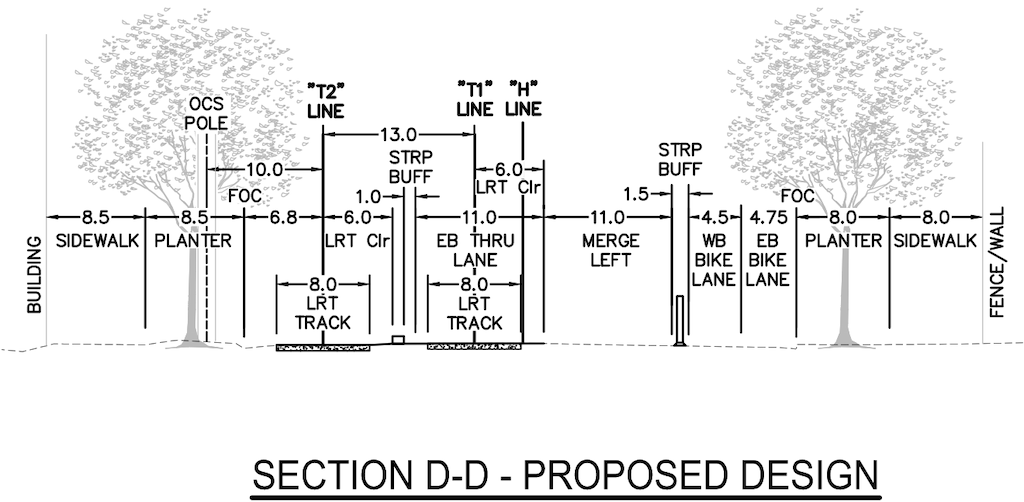
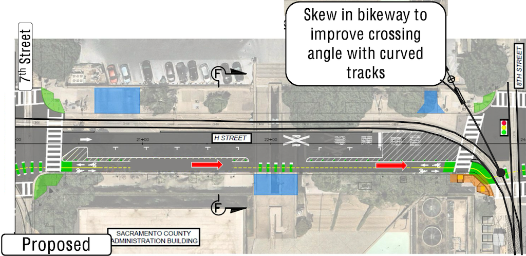
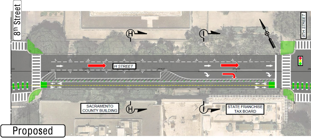
10th Street from I Street to H Street
This segment design is reasonable, given the curb extensions (bulb-outs) present at the bounding intersections. This project probably does not have the funding to reconstruct the street to create a separated bikeway, though this should be done in the long term. A separated bikeway would complete a buffered or separated bikeway on 10th Street all the way from Broadway to H Street. Despite the call-out on the image below, this is just a buffered bike lane, not a Class IV (separated) bikeway. Parking is not needed on both sides, as ample parking is available on nearby streets and in the city parking garage on the southeast corner of I Street and 10th Street.
H St Bikeway, 10th St from I St to H St, proposed (from SacATC presentation)H St Bikeway, 10th St from I St to H St, proposed cross-section, 105.5 foot ROW?, 50 foot FOC (from SacATC staff report)
Signals
The staff report diagrams use the phrase ‘Traffic Signal (Eastbound/Westbound) to be Modified or Replaced’. I am very concerned with ‘replaced’. The city has a penchant for replacing signals, and controller boxes, that do not need to be replaced, raising the cost of projects or wasting money that could be better spent on other parts of the project.
The presentation diagrams show bicycle signal faces at 5th Street and 6th Street, but not 7th Street, 8th Street or 9th Street. Bicycle signals are necessary at every intersection for the safe operation of two-way separated bikeways. It is possible they were neglected on the diagrams, but they cannot be neglected in the project.
Signal timing should be set to a ‘green wave’ of about 13 mph, to allow bicyclists continuous movement through the five blocks. If signal timing remains the same, bicyclists will encounter red light at every intersection, making the bikeway much less useful.
Every pedestrian signal in this section should include a leading pedestrian interval (LPI). Though valuable to enhance transit and bicycling, the design must not disadvantage people walking along or across the corridor.
Speed
The posted speed limit in this section is 25 mph, but observed speeds are higher. This section seems to serve, since the conversion of 5th Street to two-way traffic, as a cut-through from 5th Street to 16th Street, and the design of the intersection of H Street at 16th Street, three dedicated left turn lanes, supports this use. The speed should be reduced to 20 mph, in part to reduce the differential between motor vehicles and bicyclists. Though the bikeway separates these two uses, bicyclists will need to use the general purpose lanes at some points to enter and exit the bikeway, reaching other destinations in addition to the end points. If the posted speed remains 25 mph, and the actual speeds higher, drivers will be encouraged to speed in order to hit green lights. In the central city, many signals are set to 28 mph, encouraging drivers to speed.
Bikeway design
The width of the two-way bikeway in this five block section varies from 8.9 feet (4.0 + 4.9) to 10 feet (5 + 5). The smaller width is not enough to provide safe passage for two larger bikes, such as three-wheel bikes, cargo bikes, and bikes with trailers going in opposite or the same direction. The minimum width throughout must be 10 feet. NACTO’s Urban Bikeway Design Guide says: Two-way bike lanes should be at least 13 ft (3.9m) wide to accommodate all types of bicycles, side-by-side riding, platooning, and passing. A consistent width also allows for bikeway sweeping by devices which cover the full width of the bikeway. The City of Sacramento is deficient is maintaining its existing separated bikeways free of leaves and trash, so future bikeways must be designed for ease of maintenance.
Bikeways should be designed for maximum protection against errant motor vehicles. In blocks without driveways, a concrete curb should be installed, with small gaps for bicyclists to enter and exit. The segment between 8th Street and 9th Street is one such segment. The design with a buffer from parked cars is only effective when parked cars are present. A dedicated motor vehicle right turn lane is adjacent to the bikeway with only a very narrow buffer. The segment from 9th Street to 10th Street seems to have this protection by design. Mountable curbs, as shown for 5th Street to 6th Street may also be appropriate for parts of the 6th Street to 7th Street and 7th Street to 8th Street segments.
NACTO Urban Bikeway Design Guide
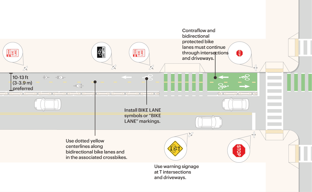
The page on ‘Designing Protected Bike Lanes‘ provide guidance on three situations, including two-way (bi-directional) bikeways. The diagram below is from that page. The page includes guidance on dimensions, marking, signs, and intersections.
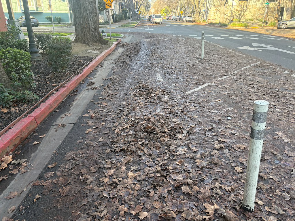
The City of Sacramento has installed a number of separated, parking-protected bikeways, including P St, Q St, 19th St, 21st St, 9th St, 10th St, and J St. It is failing FAILING to maintain these bikeways. They have not been swept by the city since the beginning of leaf season, early November.
You can find several blocks, or portions of blocks that have been cleared, but these have not been cleared by the city. They have been cleared by landscape services contracted by adjacent property management companies, mostly for multi-family housing. It is not the responsibility of these companies to clear the bikeways, but they do so both as a community service, and to maintain a higher level of appearance for their housing and businesses.
The city should be ashamed of itself. It has created a hazard of its own making.
It would probably be better if the city returned these streets to their previous configuartion, with traditional bike lanes. At least these could be swept by the city, and to some degree are swept by the wind of passing motor vehicles.
SacCity P St separated bikeway; yes there is a bikeway under the leaf piles and leaf slime
The People for Bikes analysis on Sacramento is at https://cityratings.peopleforbikes.org/cities/sacramento-ca. Note that only cities are rated, not counties, so there is no rating for unincorporated Sacramento County. Sacramento’s score was 36, Rancho Cordova’s 29, Folsom 37, Elk Grove 23, West Sacramento 25, and Citrus Heights not scored.
The lead photo on CapRadio is a concrete-separated bikeway on Broadway. But it is only one block long, and is the only one in the city.
A quote from Jennifer Donlon Wyant is revealing of exactly the problem with Sacramento bike facilities:
“M Street from Sac State to Midtown through East Sacramento is known to be an all-ages and abilities bikeway connecting schools and health care and retail, and that is shown as a high-stress facility,” she noted. “When known low-stress facilities like this are showing up as high stress, that concerns me.”
Yes, parts of M Street are great, and should be recognized with a neighborhood or greenway status. Though it is an overly wide street along much of its length, traffic is slow and light, and it meets the definition of a low-stress bikeway.
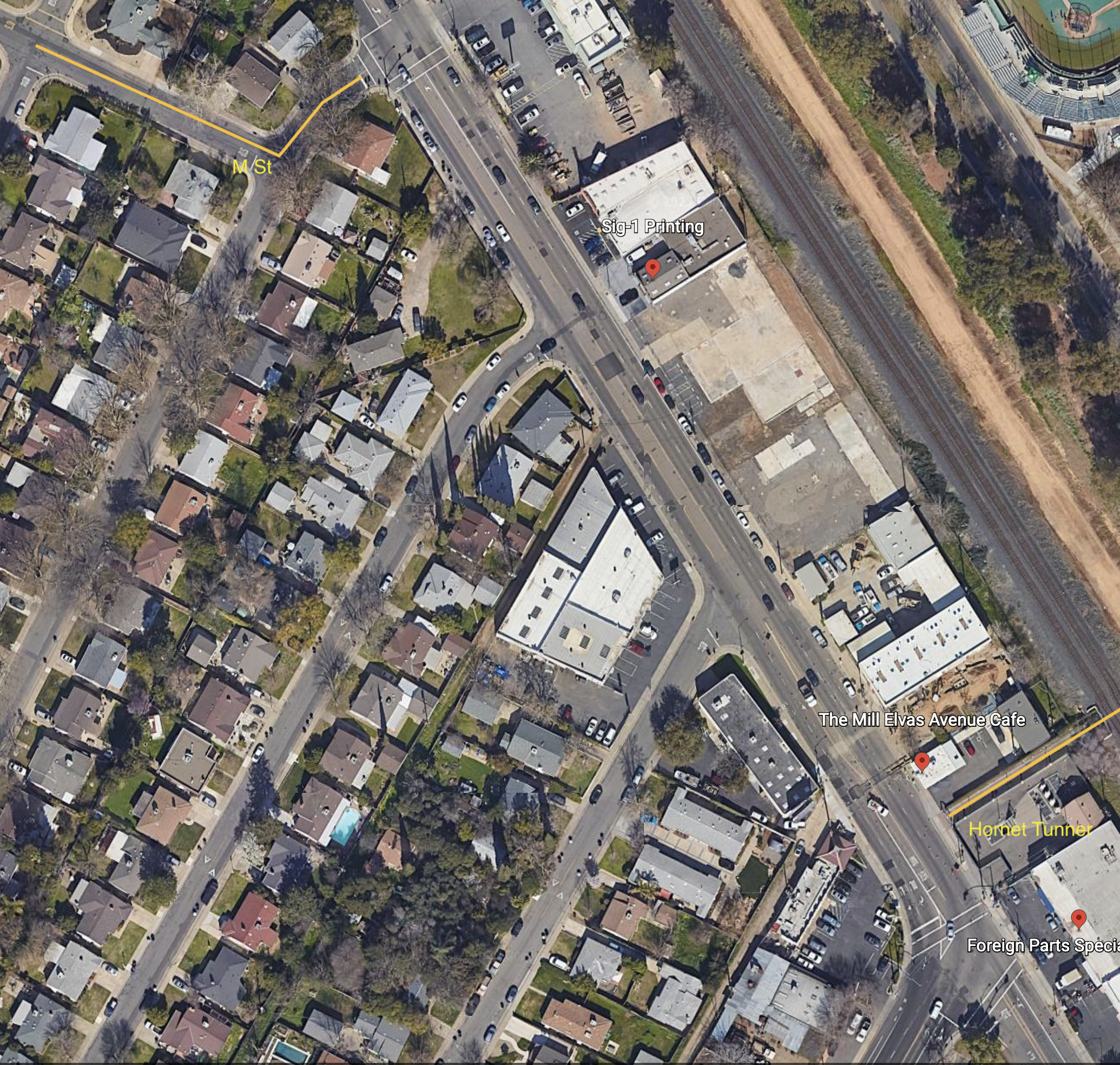
However, what happens at either end? Approaching Alhambra, M Street ends, with no bike lanes on Alhambra, and no wayfinding for how to shift to a low-stress route to continue westward. At the east end is Elvas Avenue, one of the most hazardous bike routes in the city. Bicyclists exiting onto Elvas Avenue from 62nd Street must cross four lanes of high-speed, high volume motor vehicle traffic to reach the safety of the Hornet Tunnel and SacState. Most bicyclists cross early and ride against traffic. It is slightly less hazardous to go westbound to M Street. There is no wayfinding for how to best deal with this situation.
The city has been aware of the Elvas problem for years. Nothing has been done. This blog has written about it many times: tag:Elvas-Ave.
All of the parking-protected, separated bikeways in the city are discontinuous:
10th Street northbound: starts at W Street with an awkward transition from east side to west side; ends at I Street
9th Street southbound: starts at I Street; ends at Q Street; design is very inconsistent with bike lane-only blocks
P Street westbound: starts at 21st Street; ends of 9th Street
Q Street eastbound: starts at 9th Street; ends at 21st Street
J Street eastbound: starts at 19th Street; ends at 28th Street
19th Street southbound: starts at H Street; ends at W Street with an awkward transition from east side to west side; at Broadway the route transitions to Freeport Blvd with no bike facilities
21st Street northbound: starts at W Street with an awkward transition from east side bike lane to west side separated bikeway; ends at H Street with a semi-protected bike signal
For few of these routes do the separated bikeways take you to a final destination. There are transitions to regular bike lanes, or no bike lanes at all, at the ends of each segment. That is not a connected network. It is disconnected!
Almost every advocate in the city is supportive of Jennifer Donlon Wyant and all she has accomplished to make the city more bikeable, more walkable, more livable. However, the city policy, by staff at a higher level, and city council, to spend almost none of its general fund on transportation safety, and to rely only on state and federal grants. means that the city will continue to rank low on any assessment of bicycle friendly.
Sacramento needs a connected network, and we are far from that.
Google map of Elvas Ave from 62nd St to Hornet Tunnel
Are the City of Sacramento separated bikeways on 9th St, 10th St, 19th St, 21st St, J St, P St and Q St a failure?
These separated bikeways are mostly but not entirely parking protected, meaning they are between the curb and the parking lane. The city purchased a bikeway sweeper specifically for use on these bikeways. But that sweeper has not been used this year. As documented in SacCity is not sweeping separated bikeways, the bikeways are filling with fallen leaves, which have now turned to leaf slime. Though I have not seen anyone fall on the leaf slime, I’d not be surprised, and I have slipped but not fallen several times. Some of the bikeways have been cleared, but it has been by adjacent property owners, and by City of Sacramento Youth, Parks, and Community Engagement (YPCE, otherwise called parks) on some but not all park-adjacent blocks. City of Sacramento Public Works, whose responsibility it is to sweep these bikeways which are part of the transportation system, have done nothing. Nothing.
A second issue is that the city has done nothing to solve the bikeway blocking that occurs on a daily basis on P Street approaching 16th Street. The bikeway here is blocked by delivery vehicles, people moving in and out of the adjacent residences, and people picking up food from the restaurants. The city is very aware of this problem, as there are frequent reports to 311 of illegally parked vehicles, by myself and many other bicyclists. But nothing has been done to solve the problem. This location needs, at the least, additional vertical delineators to discourage drivers from using the bikeway, and even better, a hard curb to prevent use.
It is worth noting that there is marked loading zone immediately adjacent to the bikeway, see below. Most drivers choose not to use that, or it is routinely blocked by drivers parked for a long period of time, clearly not loading.
loading zone adjacent to bikeway, P St
There are other locations where a separated bikeway is blocked by motor vehicles, but nowhere is it as common as the P St approaching 16 St location.
If the city is not willing to maintain the bikeways, and is not willing to solve issues with the bikeways of which it is very aware, then it can’t claim these as separated bikeways. Maybe they should be removed.
On the plus side, the city’s 311 app finally includes a drop down for ‘blocking bike lane’ under the parking violations menu, about five years after the request being made by myself and many others.
The section of Elvas Avenue between 62nd Street and Hornet Tunnel which leads to Sac State is very dangerous for bicyclists. Bicyclists have to transition across four lanes of traffic (three travel lanes and a center turn lane), without any protection whatsoever. The pavement quality is low, particularly on the east side where the ‘bike lane’ (not a real bike lane) is. Despite this, it is a high-use bicycle route from Sacramento to Sac State and the American River Parkway trail. M Street, this section of Elvas, and the Hornet Tunnel serve as a bicycle boulevard (though not designated) between the central city, Sac State, and beyond.
Since the day I arrived in Sacramento and rode my bike to work in the eastern suburbs, I have known that this section needs to be fixed. It took me 12 years to get around to writing about it. I hope that it will take the city less to fix it. The solution presented here is not the only solution, so I encourage others to comment, point out flaws, and suggest optimal solutions.
Elvas Avenue is a high-speed, moderately high-volume roadway that acts in many ways as an expressway due primarily to the turns from Elvas Avenue to 65th Street, and from 65th Street to Elvas that encourage high speeds. The roadway is dangerous for motor vehicle drivers and passengers as well as bicyclists. North of 62nd Street, St. Francis High School (about 1100 students) suffers from traffic risk created by Elvas Avenue, so traffic calming to the south will benefit the high school as well as bicyclists. It might be appropriate to extend the separated bikeway north to the signalized crosswalk over Elvas to the school.
Note: This post is not about the bicyclist fatality that occurred in this area recently. Not enough is known about that to post, yet. This is Central City Mobility Project update #34.
There is an issue with the 21st Street separated bikeway at W Street. The northbound bikeway transitions from the east side of 21st Street to the west side of 21st Street at W Street. There is a two-stage turn box on the northeast corner, intended for bicyclists who have crossed W Street on the green light to wait to cross 21st Street on the green light, to access the separated bikeway on the west side of 21st Street. The photo below shows the box being used by a walking bicyclist, who waited in the box. The signal has turned green and he has started to cross. A right-turning driver from W Street to 21st Street stopped suddenly to avoid hitting the bicyclist/pedestrian, because the driver did not expect to see someone there. The vegetation somewhat but not completely obscures someone in the box.
21st St at W St NE two stage turn box with bicyclist in box
The city has placed a ‘no turn on red’ sign on W Street, photo below. In about 40 minutes of observation, 60% of the drivers who could turn, meaning they were not blocked by a vehicle in front of them, did turn on red. This is the time when the box would be occupied by a bicyclist.
W St ‘no turn on red’ sign to 21st St
On the green light, drivers are taking the right turn at high speed. If there were a bicyclist or a walker crossing 21st Street, here, it is doubtful that many drivers would notice the person and brake in time. This is a severe injury or fatality waiting to happen. The video below shows drivers cutting across the two-stage turn box.
video of drivers cutting across the two-stage turn box on 21st St
Solution
A temporary solution is to install vertical delineators (flex posts) to block off the right hand lane of W Street approaching the intersection. There is a short section of red curb here, where the ‘no turn on red’ sign is, but the blocked off area should extend 20 feet up to the crosswalk, and be the width of the parking lane. A green K-71 vertical delineator, or two, should be placed at the southwest corner of the two-stage turn box, to force drivers to go around the turn box, and also slow turning movements. The diagram below indicates possible locations of vertical delineators, white dots. Base excerpted from CCMP plans.
A more permanent solution would be to reconfigure the northeast corner to add concrete barrier protection for the turn box. The city, having enticed bicyclists to this location, owes them a much higher level of protection that is currently offered.
The 19th Street bikeway has been completed from W Street to Broadway. Only a half block of the two blocks is separated bikeway, and it is on the right side rather than left side as it is to the north. At W Street there is a bike box in line with the bikeway to the north, and a green dashed bikeway to carry the bikeway from the left or east side to the right or west side. The curved area shown in the photo does not have any sort of protection to reduce turn speeds, as is present on most turn wedges in the rest of the Central City Mobility Project.
The turn intersection involves a two stage turn for bicyclists, once to cross W Street to the south side, and then to cross 19th Street to the west side. There is no separate bicycle phase or bicycle signal face here. The pedestrian crossing phohibition here and lack of crosswalk indicates two things: there is no sidewalk on the south or freeway side of W Street, and that high speed turns from W Street to 19th Street are expected and encouraged. This project would have been a great time to add a crosswalk and pedestrian signaling here, and remove the prohibition, as both sides of 19th Street under the freeway have sidewalks, so a crosswalk would speed travel for walkers by offering two routes of travel. Bicyclists using the green dashed crossing of 19th Street have turning traffic at their back, which is somewhat unsafe but could have been made safer with an exclusive bicyclist phase or even a bicyclist signal phase. Since the signal timing favors W Street over 19th Street, it could have been possible to allow both a brief bicyclist phase and a turning phase.
19th St bikeway transition to right side
Crossing under the freeway, the bikeway is partly green painted and next to a travel lane, and partly parking protected bikeway to X Street. From X Street to Broadway, it is a regular door-zone bike lane. At Broadway, there a green bike box the full width of the street, allowing bicyclists to continue straight or turn left onto Broadway.
To summarize, the design is OK but could have been better.