Fruitridge Road Safety and Mobility Plan observations

I posted on the Fruitridge Road Safety and Mobility Plan (2026-02-21), which was before the first community meeting on March 4, which I attended. There were a number of display boards with details that are not necessarily in other documents, but I did not capture those. A second workshop, on July 6, which presented updated concepts based on the first workshop and other outreach, I was not able to attend. The project website has a number of documents of interest, including all those that I reference below. Note that there is another city project, Fruitridge Road Improvement Project, east from Stockton Blvd to Power Inn Road, that is separate from this project.

The public outreach for Phase 2 is complete, and there is no formal process at this time for public input. However, you have the right as a citizen to email the project lead, Virginia Morgan, VMorgan@cityofsacramento.org.

Overall

The map below shows the corridor, and related transportation projects.

map of Fruitridge Road Safety and Mobility Project

The project extends from Riverside Blvd to on the west to Stockton Blvd on the east. The roadway from Riverside to South Land Park Drive is named Seamas Avenue, which is important if you are looking at details in the documents, but I’ll refer to the entire corridor as Fruitridge Road. The section from Riverside to Freeport Blvd is four lanes, but with fairly low traffic volumes and speeds. The posted speed limit is 35 mph. From Freeport to 24th Street, volume and speeds are higher, and the roadway has frontage roads on south and then north side. The posted speed limit is 40 mph. From 24th all the way to Stockton Blvd, the corridor is mostly commercial, with some residential here and there. Volume and speed are again higher. The posted speed limit is 40 mph, but observed speeds are much higher, particularly in the vicinity of the Hwy 99 interchange, where drivers reach highway speeds at the onramps, and continue highway speeds coming off the off-ramps. The section from east edge of the freeway interchange to Stockton Blvd is mostly within Sacramento County, not the city. This section has paint-only bike lanes, which apparently were added in 2024.

Traffic Violence

The corridor map below shows collisions. As is no surprise, they are concentrated at major intersections, but also occur in between, most likely at side streets or driveways. Few collisions are shown for the Hwy 99 onramps and off-ramps, possibly because this data was not included. Though the interchange is within the city, it is completely controlled by Caltrans and collisions would be reported by CHP, not the city. When I asked the consultants why the collision density was so much higher in the county section than the city section, they speculated that it was because there was so much more commercial activity and driveways in that section.

Sidewalks

With few exceptions, sidewalks throughout the corridor are five feet wide. Though there are problems here and there, including utility poles in the sidewalk, and a gap east of the Del Rio Trail, they are overall in decent condition. The lack of trees along this corridor does reduce sidewalk heaving. Driveways are frequent, particularly between Franklin Blvd and Stockton, including the county section. More than half of the driveways have a steep cross-slope in the sidewalk, not meeting current PROWAG/ADA requirements. Some, mostly within the county section, have been fixed with the ramp down, ramp up solution, which is legal but not optimal. Many of the unmodified driveways present barriers to travel with mobility devices, and discomfort for all walkers. All sidewalks and driveways within the project area should be upgraded to PROWAG compliance. The best way of doing so it to install a sidewalk buffer (which the city calls planting strips) so that the driveway slope in within the buffer, not within the sidewalk.

photo of side-sloped sidewalk at driveway, not PROWAG/ADA compliant (and overly wide driveway)
side-sloped sidewalk at driveway, not PROWAG/ADA compliant (and overly wide driveway)

Sidewalks should be a minimum of six feet wide, with additional width where higher walker use justifies it. Initially, the project proposed to leave almost all of the sidewalks untouched, only widening them where there are bus stops. The new Alternative 2 – Enhanced Improvements, considers but does not promise widening sidewalks along the corridor. More on this below.

I keep harping on the city’s user prioritization diagram, from the 2024 General Plan, but it is worth remembering for every single project. Not only does it show pedestrians (walkers and rollers) as the top priority, it shows a tree with the walker. The tree is essential for creating a welcoming and safe environment for people walking. But trees are the one feature most neglected in transportation planning and infrastructure. Every city project has resulted in fewer trees than were promised, despite trees being one of the top requests by the public.
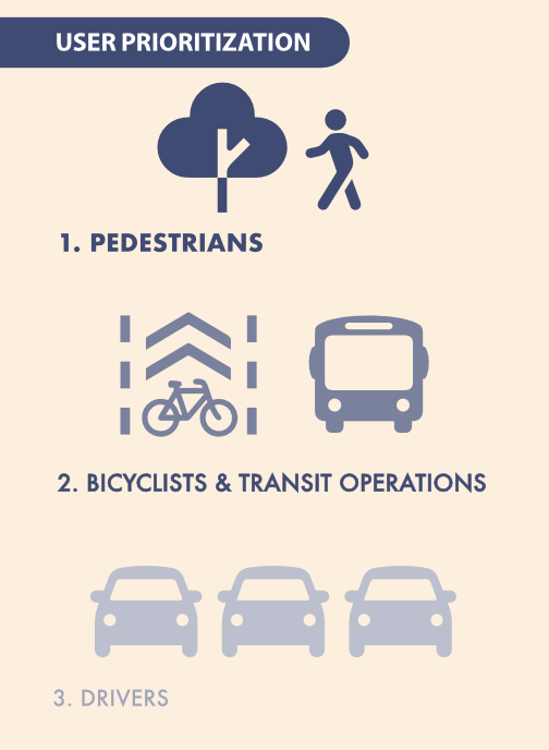
graphic of User Prioritization from City of Sacramento 2040 General Plan

Roadway re-allocation

The project plan focuses on lane number reductions and lane width reduction, and the question of whether the eastern Segment 2 from 24th Street to Stockton Blvd will be two lanes (three with center turn lane) or four lanes. I don’t think this is the most important issue, except as re-allocation allows for wider sidewalks and sidewalk buffers. I find that Alternative 2, illustrated below, is the only acceptable design of the three presented. The diagram shows a section without driveways, but frequent, poorly designed driveways are characteristic of much of Segment 2. Only this alternative allows continuous level sidewalks, with driveway ramps in the sidewalk buffer. Though at this stage of planning, the width of the widened sidewalks and new sidewalk buffers is not specified. I believe that sidewalks should be a minimum of six feet, and wider where walkers and rollers are more frequent. Bus stops should have at least eight feet of sidewalk, and most bus stops should have bus shelters and other amenities that are not within that eight feet. Buffers should be a minimum of eight feet, to allow for tree health and growth without sidewalk buckling. The city has been using buffers of 4 to 6 feet on many projects, which is too narrow.

The Phase 2 Design Alternatives document, which I assume must have been the display boards at Workshop 2, does have widths shown for the various segments, but unfortunately, these diagrams do not exactly match the diagrams in the presentation. For example, the presentation Alternative 2, below, indicates widened sidewalks, but the design alternatives document continues to show the existing five foot sidewalks.

Sidewalks should also be continuous across intersections with local streets. These raised crosswalk/sidewalks clearly communicate to drivers that they need to slow, and look, when crossing a sidewalk, that they are guess in the walker space, not the preeminent user. There may be intersections with collector and arterial roadways, and other signalized intersections, where continuous sidewalks/raised crosswalk are appropriate.

Bicycle facilities

Alternative 1 shows paint-only Class 2 bicycle lanes. These are unacceptable on roadways over 30 mph, and with the current speed limits at 35 mph and 40 mph, they are not safe. Unless posted and design speed limits are reduced to 30 mph on the corridor, bicycle facilities must be protected with at a minimum, wide buffers with vertical delimiters, and preferably and safer, concrete medians and curbs. Without width specification, it is unknown whether these facilities will accommodate modern bicycles and riders. But as with all bicycle facilities, the more important issue is how bicycles are accommodated at intersections. The city has not done well with this issue.

Intersections

Intersections are where most collisions occur, and the locations where walkers and bicyclists are most at risk, and most discouraged, but the documents available to date don’t show intersection modifications.

There are two intersection in the corridor that must be significantly modified to make them safe for all users. At Fruitridge Road and Freeport Blvd, the intersection flares to have five westbound lanes, with two dedicated left turn lanes, two through lanes, and one dedicated right turn lane. A crossing distance of 113 feet! Eastbound, four lanes, with one dedicated left turn lane, two through lanes, and one dedicated right turn lane. A crossing distance of 100 feet! There are problems with the design of Freeport Blvd as well.

overview of Fruitridge Rd & Freeport Blvd flared intersection
Fruitridge Rd & Freeport Blvd flared intersection

The intersection of Fruitridge and 24th Street is acceptable, though it could certainly be improved.

The intersection of Fruitridge and Franklin Blvd is unacceptable, with a similar flared design. The free right turn slip lanes from Franklin to Fruitridge are a clear and present danger to all users of the roadway, particularly walkers and bicyclists. These should have been removed as part of the Franklin Blvd Complete Streets project. And they should be removed citywide.
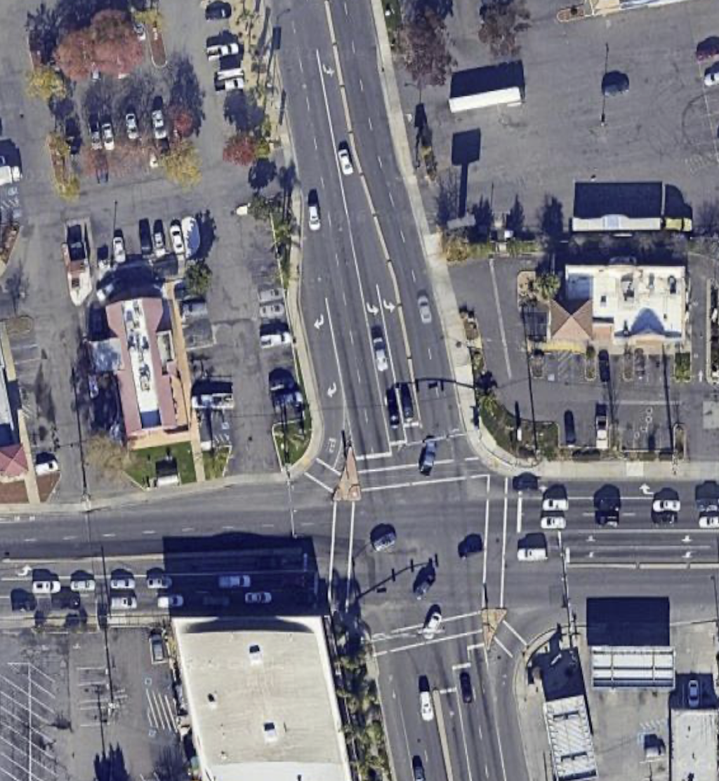
overview of Fruitridge Rd & Franklin Blvd flared intersection
Fruitridge Rd & Franklin Blvd flared intersection

The intersection of Fruitridge Rd and Stockton Blvd is the third problematic intersection, though it isn’t clear to me whether changes will be part of this project, or the future Stockton Blvd Stockton Transportation Enhancement Project. On Fruitridge, it is not as bad as the two preceding intersections, but the intersection is a vast area of pavement, unfriendly and unsafe for walkers and bicyclists.

These flared intersections create large number of conflict points for motor vehicles, and lengthen crossing distances for walkers to unacceptably long distances. Long crossing distances also slow signal cycles due to the longer pedestrian crossing time, frustrating drivers as well. They also encourage drivers to jockey for position at intersections, and accelerate hard to get ahead of others. Though not a common behavior, belligerent drivers also use turn lanes as bypasses for slow traffic in front of them, creating a high level of danger for everyone. The city has, in the past, installed these flared intersections to create stacking space for motor vehicles at signals, but shortening signal cycles can have the same beneficial impact.

I believe intersections should never have dedicated right turn lanes, and particularly, not ones leading to free right turn slip lanes. Right turning drivers can wait their turn with everyone else. Intersections should only have one dedicated left turn lane. Two or more turn lanes lead to motor vehicle conflict on turns, higher speed turns, and inattention by drivers to people in the crosswalk and bicyclists. Whether there are one or two through lanes (never three or more), depends upon the intended design use of the road. Not on existing traffic counts, but on intended use.

Hwy 99

The worst ‘intersection’ of all is the Fruitridge Road & Hwy 99 interchange. This interchange features three high speed onramps from Fruitridge Road to Hwy 99, and three high speed off-ramps onto Fruitridge Road. It is not a true cloverleaf interchange, which would have four of each, but it is bad enough.

On eastbound Fruitridge, the south side, bicycle lanes are dropped, and so are sidewalks. There are ‘no pedestrian’ signs approaching from the west and east. There are no marked crosswalks or pedestrian warning signs or ramps over the two onramps and one off-ramp. The sidewalk on that side is basically an isolated fake. I watched these ramps for some while. Drivers were entering the onramp to Hwy 99 southbound at highway speeds, far over the posted 40 mph speed limit. The off-ramp on northbound onramp were not as bad because they lead to fairly tight turns, and presumably most drivers know that excessive speeds will cause roadway departures.

On westbound Fruitridge, the north side, bicycle lanes are dropped, but there is sort of a sidewalk. There are sidewalk ramps to unmarked crossings of the one onramp and two off-ramps. There are even pedestrian crossing signs at each, and the west off-ramp, even added yield signs, though those may be for merging to Fruitridge, and not for the crosswalk. I watched the west off-ramp for a while. Every driver was exiting at highway speeds, though the posted speed limit is 40 mph.

I believe that all freeway interchanges should have right-angle entry and exits from surface streets, which cause drivers to stop, or at least greatly slow. If a walker or bicyclist got hit at such a ramp, it would be a low speed collision, and probably survivable. For the high speed ramps of this interchange, a collision with walker or bicyclist would almost certainly be fatal. When a city or county want to redesign an interchange to be safe, Caltrans response is almost always: ‘we’ll work with you on the design, but you are going to pay for the infrastructure, 100%’. Caltrans knows that its interchanges are deadly, but has no interest in fixing them. Cities and counties can rarely afford to do so. As for the lack of mapped collisions (see diagram above), I believe that collisions that happen at the exit of the off-ramps and entry of the onramps are considered to be on a state highway, under the jurisdiction of CHP and not Sacramento Police, so don’t show up in the city’s data.

overview of Fruitridge Rd & Hwy 99 interchange
Fruitridge Rd & Hwy 99 interchange

Bus stops

The designs use the phrase ‘Transit stops will need to be designed to accommodate bikeways’, but there are no diagrams or descriptions of what these would look like. This is a very important issue. The optimal bus stop is at a transit boarding island where the bus stops in the travel lane rather than pulling out of traffic. However, other options are possible and may be more compatible with the overall roadway design. An unanswered question.

The Upshot

Segment 1, from Riverside Blvd to Freeport Blvd, at perhaps at far as 24th Street, should be delayed. The traffic on this section is lower volume and lower speed than the rest of the corridor. Though it would be easier to re-allocate roadway width here, it does not have the same safety value. For Segment 2, to the east of 24th Street, and perhaps including the section from Freeport Blvd, the nature of the roadway, driver behavior, conflict points, and adjacent land uses changes completely. This is where the real problem is, and should be the focus of the project.

Hazardous intersections, particularly at Freeport and Franklin, must be fixed in this project, and these intersections are more important than fixing the corridor, because intersections are where the most conflicts occur, and therefore the most collisions. Even if the city fixed only those two intersections, the project would be progress.

Sidewalks for walkers and rollers are the most important aspect of any re-allocation project, of course more important than motor vehicle throughput, and even more important that bicyclists. Only Alternative 2 provide reasonable infrastructure for walkers and rollers. Sidewalks must be a minimum of six feet wide, even in low-use sections, and wider or much wider in heavily used sections. These sidewalk must be shaded by trees, which must be planted at about 30 foot intervals within sidewalk buffers (planting strips) of at least eight feet wide. Of course that means robust irrigation for trees and other plants during the period of establishment.

Wide concrete buffers, of the sort shown in Alternative 1 – Base Improvements, are a waste of concrete. Wide concrete buffers (8.5 feet!) are no more protective of bicyclists than 18 inch buffers, are a waste of project funds, and add to heat island effects of the roadway. The new Franklin Blvd Complete Streets unfortunately has a number of these. Don’t use them!

The city continuously refuses to reduce posted speed limits on reconstructed streets, with their faulty logic that speeds cannot be reduced without a speed study that shows lower 85th percentile speeds. But reconstructed, complete streets are essentially new streets, as though they had been constructed from scratch. The city can, and should, determine an optimal design and posted speed (which should be the same, not the over-engineered forgiving design speed of 10 mph or more over the posted speed). For this project, the design and posted speed should be 30 mph. Designing for slower traffic is even more important than reducing travel lane numbers.

Freeport Blvd as a failure of vision and possibility

Another post on the Freeport Blvd Transportation Plan. See the category Freeport Blvd for other posts.

It should be obvious, if you have been reading, that the City of Sacramento’s Freeport Blvd Transportation Plan is a failure of vision and possibility. How so?

The city removes from all planning efforts the possibility of reducing speed limits on streets that are reconstructed, usually complete streets projects. Whatever the speed limit is before the project will be the speed limit after the project. I’ve written about this before: lower speed limits on complete streets in Sac. I get that changing posted speed limits without changing roadway design has only limited effect in lowering speeds. But we are talking about reconstructing streets, the very design changes that are necessary to effectively lower motor vehicle speeds. Yet the city refuses to consider lowering speed limits when planning reconstructed roadways. Posted speed is like a rachet, it can only increase but never decrease. Some planners and engineers go so far as to claim that the law prevents lowering of speed limits on reconstructed streets. That is a lie.

The city also refuses to consider lane reductions (also called road diets, roadway reallocation, or right-sizing) when average daily traffic counts (ADT) are above certain thresholds. It will not consider that ADT is above what it should be because the city earlier widened roadways and induced the travel that is now resulting in high ADT. Again, lane counts are like a rachet that goes only one direction. You can increase lanes, but you can’t decrease lanes, except in situations where the roadway is so obviously overbuilt that it would be ridiculous to suggest maintaining that number of lanes.

The city has a responsibility to reduce vehicle miles traveled (VMT) in the city, under state law, under SACOG guidance, and its own policy in the Mayor Climate Change Commission Report and Climate Emergency declaration. Yet in transportation planning, the city seems to be fully committed to maintaining the current levels of VMT by ensuring that the current levels of traffic are not reduced. This is climate arson.

Community input to the Freeport Blvd planning process provided high priorities: safety, economic vitality, and walkability. Yet the plan maintains motor vehicle capacity, ensuring that the community priorities will be only partially met. This is not a compromise between drivers and walkers and bicyclists. It is throwing crumbs to the walkers and bicyclists so that drivers may eat nearly the entire cake.

Freeport Blvd, today, is a suburban form. Uninviting streets, hostile walking and bicycling, many small businesses in strip malls and a few big box stores (some of them closed or failing). The built environment is an artifact of the time and way in which Sacramento grew in this direction. It is a fact. But the city, in its transportation plan, makes no effort to change or mitigate that fact. In no way does it even suggest transformation to a more vibrant and interesting place. At the simplest level, it just adds bike lanes and changes nothing else. I’m not against bike lanes, and certainly not against separated (protected) bikeways, but they are not transformative. What would be transformative is shifting Freeport towards a walking-first transportation corridor, a destination for people who live there and people who travel to there.

The city intends to add a number of new crosswalks to the corridor. That is good news, as distances between safe crossings are too great. The problem is, most of these will require extensive signalization to protect the people crossing there, because speed limits are such that a person hit by a motor vehicle will be seriously injured or killed. Lower speed limits, not just posted but enforced by design, would allow much less expensive crossings. Money matters. The city will put very little of its own funds toward these changes, depending mostly on regional, state and federal funds, which will always be too little and too slow.

This plan is only the first step in changing the roadway. Grants will be solicited for major project work. A few critical locations will be improved in the near term. But the plan as a whole is decades away from completion, particularly if the probably unnecessary section south of 35th St is included. The city has done pretty well obtaining grants for complete streets, but with an entire city full of streets needing improvement, Freeport Blvd can’t be and won’t be the only priority. Once the plan projects are complete, the street won’t likely be changed for 30 years. So 50 years from now, more or less, the roadway will look like what the city has planned today. Will it meet the needs of citizens at that time? Very, very unlikely. In the future, VMT will be and must be much lower than it is now. A much higher percentage of trips will be made by walking and bicycling. The built environment will densify, with more small businesses, though some stretches won’t make it and will fail. That’s OK. Properties with failed businesses are good candidates for infill housing, which will support those businesses remaining. But housing along a dangerous traffic sewer, as Freeport Blvd currently is and will largely remain under the city plan, is a disservice to everyone who lives there. Who wants to live on a busy arterials stroad, where you can’t let your kids outside because the risk of traffic violence is too great, and the air hazardous to breathe, and the noise of traffic is a constant psychological and health danger? Riding to the grocery store may be slightly more pleasant and somewhat more safe, but many people still won’t want to because they aren’t comfortable with regular bike lanes beside high speed traffic, and complicated intersections. People won’t want to walk during the summer because the city failed to plan for and install trees along the sidewalks.

Enough said for now. I may write some more or post others if people point out important issues that I have not addressed. Otherwise, the next post will be just before the plan goes to city council, in hopes that citizens will urge the council to reject this plan as too flawed for use. I was very disappointed that the City of Sacramento Active Transportation Commission rubber-stamped the plan and passed it along to council, but that is water under the bridge.

The city can do better, but only if a significant number of citizens press their council members to set a higher standard for transportation planning than is exhibited in the final draft plan.

Freeport roundabout(s)

Another post on the Freeport Blvd Transportation Plan. See the category Freeport Blvd for other posts.

The city has proposed a roundabout for the intersection of Freeport Blvd and Sutterville Rd E. This is a good location for a roundabout, in part because there is so much space here already that a roundabout would not encroach on other uses.

Notes: I am calling the section of Sutterville Rd to the east of Freeport ‘Sutterville Rd E’ and the section to the west of Freeport ‘Sutterville Rd W’, but these names do not reflect street addresses, since this is all East Sutterville Rd. This post introduces the idea of protected intersections along Freeport, which apparently were not considered by the city in their planning process. For more information on this design, see protected intersections and Davis protected intersection.

First, what it looks like today. As you can see, there is a huge area of wasted space in the intersection

Freeport - Sutterville E intersection existing
Freeport – Sutterville E intersection

Second, the roundabout proposed in the plan.

Freeport - Sutterville E roundabout proposed
Freeport – Sutterville E roundabout proposed, north is to the right
Read More »

Freeport trees and sidewalk buffers

Another post on the Freeport Blvd Transportation Plan. See the category Freeport Blvd for others.

So, given the need for trees to shade sidewalks along Freeport, where do they go? The answer is in the sidewalk buffer or planting strip. At one existing location along Freeport, there is an example of street trees in a sidewalk buffer, where the new Raley’s shopping center is. The photo below is from the photo essay. I don’t know whether the city required the developer to put in sidewalk buffers and wider sidewalks, or whether the developer knew this was the right thing to do and did it on their own. In any case, this is the only part of Freeport that has them, other than a short section along the airport north of Blair Ave.

The one situation in which sidewalk buffers may not be appropriate is where buildings come to the curb in dense retail areas. But there are virtually no instances of this along Freeport. Almost all buildings are set back from the sidewalk a little, or a lot. In several cases there are massive parking lots adjacent to the sidewalk, creating the kind of place where no one wants to be. So buffers and trees at least mitigate the blandness to some degree.

Freeport Blvd sidewalk buffer and trees
sidewalk buffer and trees along Freeport Blvd at Raley’s

As with any post, I look for example photos and diagrams. So I searched Google for ‘sidewalk buffer’. Lo and behold, the second item is my own post about this! It is experiences like this that make me realize the value of this blog, when other people are using my advocacy work in their advocacy work.

So, so rather than re-write the post, I’ll link to it here: sidewalk buffers. I encourage you to take a read. Trees, and the sidewalk buffers that would allow them, are probably the most important aspect of Freeport Blvd, and the most important topic that the city has neglected.

Where are the trees on Freeport?

Another post on the Freeport Blvd Transportation Plan. See the category Freeport Blvd for others.

If you take a look at the Freeport Blvd Transportation Plan, including Appendix F Design Layout, you will see that most of the existing trees are preserved. But there is no information about new trees, not in the diagrams, not in the text. In fact, the only text mention of trees, other than existing trees, is in the Community Vision (page 20, 23 in the pdf), where it says “4 IMPROVE SHADE AND COMFORT: Enhance the walking and bicycling experience along the corridor by integrating street trees to provide shade and comfort from the sun and rain”. Certainly, that is the community’s vision, but it does not seem to be the city’s vision. If it were, the plan would have addressed trees.

Given that a major objective of the plan is to make Freeport Blvd more walkable, the lack of trees and mention of trees is concerning, to say the least. When questioned about trees at the January 18 Active Transportation Commission meeting, city staff said two things: 1) we aren’t the experts in trees, so we didn’t include them, and 2) tree information will come later in the design process.

This is a classic case of planning and engineering gaslighting. The story beforehand is always, well, it’s too early in the planning process to consider that. The story later is that it is too late to consider that element of the plan, we’re already past that, the decisions have been made. Every plan goes that way. It is true that this plan is only the first step in design, and there will be more detailed design to come, but when you don’t plan for trees from the beginning, you get a roadway with too few trees. Or no trees.

Almost all the existing trees are in median strips at a few locations along the roadway. Trees in medians have some value. They make the road look prettier, they slow traffic to a slight degree, they shade pavement and slightly reduce the heat island effect. But they are not even as remotely useful as trees along sidewalks. What Freeport Blvd needs is trees adjacent to sidewalks, not median trees. But the city has nowhere reserved space for them. So they won’t be there.

Next post is about where to put the trees, adjacent to sidewalks.

Freeport & Fruitridge intersection

Another post on the Freeport Blvd Transportation Plan. See the category Freeport Blvd for others.

The plan states, page Appendix A-9, “Fruitridge Road: The left turn from Freeport Boulevard to Fruitridge Road includes two left turn lanes, which may not be needed given the turn volumes. U-turns are moderately used at this location.” Despite this statement, the plan for this intersection is to leave it essentially unchanged. The diagram from Appendix F Design Layout is below.

Freeport - Fruitridge intersection design
Freeport Blvd Transportation Plan, Freeport-Fruitridge intersection design

The same seven lanes across for the north side of the intersection (to the right in the diagram), 86 feet for a person using the crosswalk, with no pedestrian refuge in the middle. Long crosswalks like this require a long pedestrian signal to meet federal standards, which of course slows all other movements in the intersection. In an effort to ease motor vehicle traffic by maintaining unneeded lanes, the city is actually slowing down everyone at the intersection, and making traffic worse rather than better.

The same dedicated double left turn lanes southbound (from the left). The same dedicated right turn lanes which require right turning traffic to conflict with the bike lane as they merge (out of the diagram left and right). The same free-right, high-speed slip lane from Fruitridge westbound to Freeport northbound which presents a tremendous hazard to walkers, bicyclists, and drivers traveling on Freeport.

Again, the city has released a final draft plan which fails to meet the needs of the community, fails to calm traffic, and fails to keep people (walking, bicycling, and driving) safe.

make Freeport 3 segments

Another post on the Freeport Blvd Transportation Plan. See the category Freeport Blvd for others.

I rode Freeport Blvd today to refresh my memory of the roadway and surrounding, and to take photos to illustrate points I want to make. Photos to come.

What was clear to me is that the part of Freeport Blvd from Claudia Dr to Blair Ave is completely different in character from the rest of the ‘south’ segment identified in the Freeport Blvd Transportation Plan. Starting just south of Fruitridge Rd, the east side is the Sacramento Executive Airport, a long stretch of chainlink fence all the way to almost Blair Way. The west side is a mix of businesses and empty lots, but about half of the businesses are closed. The Sacramento Safety Center, just south of Claudia Dr, offices for police and fire, is a one-story building surrounded by a sea of parking, the worst sort of suburban form that doesn’t even generate any property or sales tax. Nor, I’m pretty sure, does it generate any walkers or bicyclists.

Freeport Blvd south of Fruitridge is a different sort of roadway that deserves to be treated as such in the plan. But it is not. This section also has a significantly lower ADT (average daily traffic) count that much of the rest of the plan area.

Yet another flaw in the plan that should be corrected before it is adopted.

wide lanes on Freeport

Another post to criticize the City of Sacramento’s Freeport Blvd Transportation Plan. See Freeport Blvd category for earlier posts.

The city has designed Freeport with four lanes, each 11-feet wide. NACTO (National Association of City Transportation Officials) and FHWA (Federal Highway Administration) recommends 10-foot lanes for urban areas. The city says 11-feet is necessary for buses and commercial vehicles, and insists on that width in all designs for arterials and collector streets (otherwise known as stroads), or which Freeport is one.

The diagram below, from the plan document, shows the 11-foot lanes. Even if one assumes that the outside lane (called number 2 lane in engineering parlance) needs 11 feet to handle buses and commercial vehicles, the inside lane (called number 1) does not need to be any more than 10 feet, and in fact could probably be 9 feet. The widest common vehicles are 6.5 feet wide, and most 6 feet, so 9-10 feet is plenty. The city is wasting two to four feet of roadway width on extra-wide lanes. That wasted width could instead be used for sidewalks and trees shading sidewalks.

The center median is 20 feet wide, for unknown reasons. Maybe to accommodate left hand turn lanes, perhaps pedestrian refuge medians, or trees. Trees certainly need 8 plus feet, but not 20 feet. But even an 11-foot lane plus 6 feet for a refuge median is only 17 feet, but the city has designed 20 feet. Maybe to accommodate the double left hand turn lanes southbound at Fruitridge Rd? Double left hand turn lanes have no place in an urban setting like Freeport, they just increase the crosswalk distance and engender greater hazards for everyone, including drivers. It is almost as though the city is trying to waste roadways width.

Note that the sidewalks would be as narrow as 5 feet in some locations, and never wider than 9 feet or 11 feet. Note that there are no trees adjacent to the sidewalk. The next post will be about trees.

The city’s blockheaded insistence on 11-foot lanes means that they have designed a roadway which will encourage higher speeds, which are hazardous to everyone, walkers, bicyclists, and drivers. Why? Because the city’s primary design criteria is to maintain vehicle volume (VMT) and speed. This is not what the community wants, as is made clear in the workshops and surveys the city did. The city ignored community input because it did not match their preconceived notions about what kind of roadway they wanted.

City of Sac blind adherence to ADT

Another post on the Freeport Blvd Transportation Plan. See the category Freeport Blvd for other posts.

“We are designing for the traffic we have, not for the traffic we want.”

Ali Doerr Westbrook, Chair of Sacramento Active Transportation Commission

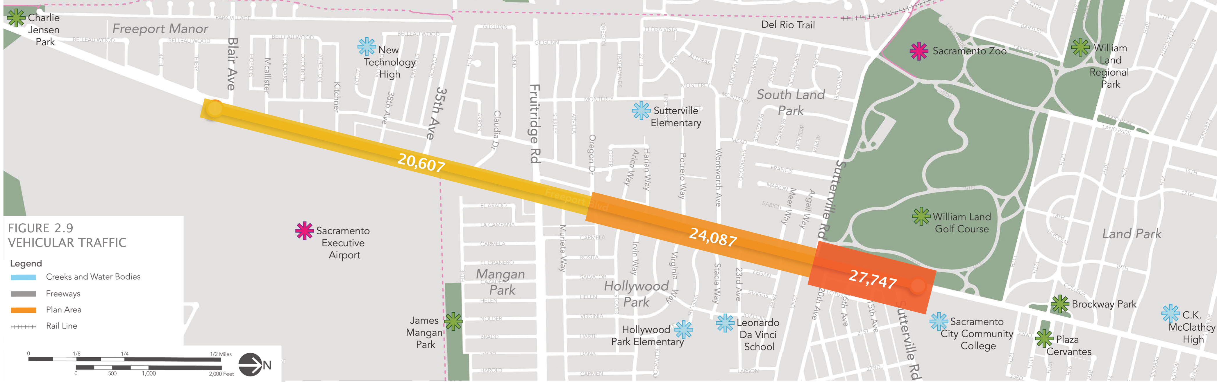
I could stop at that, but perhaps you’d like some more detail. This comment was made during the Sacramento Active Transportation Commission (SacATC) meeting on January 18, 2023. The context was the admission by the two city planners, Leslie Mancebo and Jennifer Donlon Wyant, that the city eliminated the possibility of a road diet (roadway reallocation) before even starting planning for Freeport Blvd. The reason expressed is that the ADT (Average Daily Traffic count) is above 20,000 for Freeport, and that requires more than two lanes (one each direction). Interestingly, ADT counts for various locations along Freeport are nowhere to be found in the plan or appendices. In a different location on the City of Sacramento website, Traffic Counts, the ADT for various locations along Freeport Blvd, rarely exceed 20,000, and have not exceeded 20,000 since 2011. There is no indication that the city even did new traffic counts in preparation for this planning effort. So far as can be determined, they just decided to not consider a road diet from four lanes to two lanes, or two+one lanes, 3/2 configuration) because they wanted to prioritize motor vehicle traffic over all other uses of the roadway.

The city planners also acknowledged that a road diet was a prominent request of the community during the planning process. But, community input be damned, the city is going to serve car drivers before anyone else.

A reduction of lanes from four to two is the single most important traffic calming effort that can be made on a roadway. That does not mean it is the appropriate solution for Freeport Blvd, or for all of Freeport Blvd in the planning area. What is does mean is the that city should have considered it in the planning process.

Back to Ali’s comment. The city is planning for a roadway configuration that should have already been in place years ago, before the city over-widened the roadway, and in several cases narrowed sidewalks to accommodate the widening. They are not planning for a roadway which would reduce vehicle miles traveled (VMT) or increase safety and access for those outside cars. The city’s responsibility, under the Mayors Commission on Climate Change report, is to reduce VMT in order to reduce greenhouse gas emissions (GHG), not to maintain VMT at current levels. But this Freeport plan is a plan to guarantee current VMT for at least 30 years in the future, which is about the length of time before the city will be able to reconstruct the roadway again, and correct the mistakes they made this time around.

The intent of the city in this plan is made very clear in the common design principles: “10. Maintained necessary travel lanes, turn lanes, and parking: Maintaining travel lanes and turn lanes ensures that drivers traveling along the corridor will not be compromised, and preserving parking spaces where 5 the utilization is higher so it serves better adjoining businesses.” Though this is the last item in the list of ten, it is clear that this is the highest priority for the city.

The refusal to consider a road diet/lane reduction/roadway reallocation is a fatal flaw in this plan. The effort should be sent back to staff to re-do. It should not be adopted by city council. If the city council does not reject this kind of flawed planning, city staff will continue to make the same mistake, again and again and again.

I’ll post on some of the other flaws in the plan, but this is the most important, not just because it misses the best opportunity for traffic calming, but because it retains roadway width for the exclusive use of motor vehicles that could be better used for walking, bicycling, trees, and even parking for businesses.

Added graphic below, which I had not noticed in the plan, that documents vehicular counts on sections of Freeport Blvd. Is it suspicious that half of the plan area is ‘just’ over the city’s criteria of 20,000 ADT? Remember, the plan itself and the city’s traffic counts website do not indicate this level of ADT.