The plan states, page Appendix A-9, “Fruitridge Road: The left turn from Freeport Boulevard to Fruitridge Road includes two left turn lanes, which may not be needed given the turn volumes. U-turns are moderately used at this location.” Despite this statement, the plan for this intersection is to leave it essentially unchanged. The diagram from Appendix F Design Layout is below.
The same seven lanes across for the north side of the intersection (to the right in the diagram), 86 feet for a person using the crosswalk, with no pedestrian refuge in the middle. Long crosswalks like this require a long pedestrian signal to meet federal standards, which of course slows all other movements in the intersection. In an effort to ease motor vehicle traffic by maintaining unneeded lanes, the city is actually slowing down everyone at the intersection, and making traffic worse rather than better.
The same dedicated double left turn lanes southbound (from the left). The same dedicated right turn lanes which require right turning traffic to conflict with the bike lane as they merge (out of the diagram left and right). The same free-right, high-speed slip lane from Fruitridge westbound to Freeport northbound which presents a tremendous hazard to walkers, bicyclists, and drivers traveling on Freeport.
Again, the city has released a final draft plan which fails to meet the needs of the community, fails to calm traffic, and fails to keep people (walking, bicycling, and driving) safe.
The ten common design elements on page 21 (24 of the pdf) include: “10. Maintained necessary travel lanes, turn lanes, and parking: Maintaining travel lanes and turn lanes ensures that drivers traveling along the corridor will not be compromised, and preserving parking spaces where 5 the utilization is higher so it serves better adjoining businesses.” This is statement is contrary to all walkability, bikeability and vision zero goals. It should be removed from the document, and removed from planning goals. It is offensive. It means that no matter what other improvements to the corridor will be made, cars and motor vehicle drivers will be preferenced over all others.
The ten common design elements do not mention trees. Trees are an integral part of the walking experience, as well as providing climate and heat island benefits. They should be prominently recognized throughout the document, but they are not. The phrase ‘existing trees’ occurs many time in the document, but nowhere are ‘proposed trees’ identified.
Frequent driveways along much of this section present hazards to walkers and bicyclists, and handicap the design of safe streets. It is clear that the city did not consider reduction or narrowing of driveways to address this hazard. If you look at the design layouts (Appendix F), the number of gaps in the bikeway, shown as dashed green, is remarkable. Each of these is a driveway. Again, this is a clear indication that the city intended to maintain the car-dominated character of this street.
All crosswalks at intersections should contain all three or four legs (three for T-intersections). The design leaves many intersections with only one crosswalk over Freeport Blvd, meaning pedestrians must cross three streets in order to reach some destinations, rather than just one. Though not mentioned in the plan, this often means installing pedestrian crossing prohibition signs and barriers. These should be outlawed, not encouraged.
North Section
pages 25-26 (28-29 in the pdf)
The intersection of Sutterville Road to the east with Freeport Blvd is shown with a two-lane roundabout. Two lane roundabouts have almost none of the traffic calming and safety benefits of one lane roundabouts, in fact they should not even be called roundabouts, with the implication that they have safety benefits. This roundabout should be redesigned to a single-lane. Traffic levels on Freeport to the north certainly do not justify two lanes, in fact Freeport become single lane each direction a short distance to the north at 13th Avenue.
The dedicated right turn lane on Freeport Blvd southbound at Sutterville Road to the west is not needed and presents an unnecessary hazard to bicyclists. Dedicated right turn lanes should be eliminated from this plan, and from all city roadways. They are rarely justified by traffic volume, create conflicts for bicyclists, and widen roadways and therefore crossing distances for walkers. They also encourage drivers to make right hand turns without looking for people walking.
There should be a crosswalk on the north side of the Freeport-Sutterville intersection. There is no justification for leaving it out, unless an attempt to discourage walkers from accessing the park.
South Section
pages 27-31 (30-34 in the pdf)
The offset crosswalks with median refuge at Oregon Drive and Potrero Way/Virginia Way are a good design, but there is no reason to not provide crosswalks on the other leg of the intersection.
The median gap at Arica Way, with dedicated left turn lanes, is not needed. Arica Way is a low volume street that is a good candidate for right in/right out treatment. The shopping center access can be provided for northbound traffic.
At the intersection of Fruitridge Blvd and Freeport, there should be no dedicated right turn lanes. They create a hazard for bicyclists, that cannot be mitigated by pavement marking, and they lengthen the crossing distance for walkers. In this location, where center refuge medians are not proposed, this is particularly egregious. The dual left turn lanes southbound on Freeport are a hazard to bicyclists and motor vehicles, and should be reduced to a single left turn lane. This intersection, due to long crossing distances, should provide center refuge medians on both the north and south crosswalks.
The City of Sacramento, that bastion of doing the least amount possible, has failed to notice that progressive cities in the US and worldwide are making changes to their environment to make is safer for people who walk and bicycle, and more efficient and welcoming for people outside of cars.
What the city is NOT doing, that it could:
Accept responsibility for maintaining sidewalks, as an integral part of the transportation network. The city continues to shirk its responsibility, spending funds on motor vehicle infrastructure instead of maintaining walker infrastructure.
Installing leading pedestrian intervals (LPIs) at every traffic signal in the city. The same eleven have been in place for years; none have been added. The recent legislation, AB 2264, only applies to state highways; it is up to cities and counties to implement on other roadways.
Daylighting intersections. This means removing parking from within 15-20 feet of the crosswalk or stop bar, either by painting and enforcing red curbs, or building curb extensions (bulb-outs) at every intersection. Upstream, approaching the intersection, is the big safety feature, downstream, leaving the intersection is much less important. There are interim solutions here, such as painting curb extensions and using soft-hit posts (vertical delineators).
Implementing construction zone requirements that accommodate walkers and bicyclists. The current city policy is to provide safe bypasses only if it does not in any way inconvenience drivers. The public has asked that a policy be developed along the lines of the Oakland construction policy, but the city has stonewalled against that.
Making transportation improvements that benefit walkers and bicyclists, except with county, state or federal grants. The city simply will not spend any of its general funds on improving transportation safety.
Waiting until a roadway is completely repaved to reallocate roadway width to bicycle lanes or separated bikeways, or transit. Compounding this issue is that the city doesn’t share with the public the repaving projects that it intends to do, so the public has no chance to comment beforehand.
Lowering speed limits citywide. While it is true that spot reductions have little effect on travel speeds, there are a growing number of cities that have lowered speed limits citywide, with a significant reduction in speed.
Enforce traffic laws. The Sacramento Police Department has essentially stopped enforcing laws related to the safety of walkers and bicyclists. This of course is also true in many other places. Police don’t see traffic safety as an issue worthy of concern. Of course so much of law enforcement is used as pretext to oppress, and I’m not in favor of any of that, but if the police won’t even enforce failure to yield to people in the crosswalk, what use are they? We would all be much safer if traffic law enforcement were removed from the police, largely automated, and the money saved diverted to real community needs. Yes, defund the police.
Painting marked crosswalks at every intersection. Yes, I know that unmarked crosswalks are legal crossings, but most drivers either don’t know or don’t care, so marking crosswalks is critical.
Remove beg buttons. These buttons, which sometimes a walker must press to get a walk sign, and sometimes don’t need to press (this is called auto-recall) are a direct attempt to discriminate against people walking. The city, after much pressure from the public at the beginning of the pandemic, set five crossings to auto-recall, out of the thousands. Of course they didn’t change the signing, so people walking don’t know this. The city it being intentionally obstinate in its defense of this outmoded requirement.
Remove pedestrian prohibition signs unless that is a demonstrable safety reason for the prohibition. There are numerous signs all over the city that were placed solely to preference motor vehicle drivers over people walking. The default should be that every one is removed unless the city wishes to do a traffic study to justify them.
Install traffic diverters (mode filters) all over the city. These diverters, which allow bicyclists free travel but turn motor vehicle drivers aside, are the single most effective safety measure that city could implement. But the city has decided to take these off the menu of solutions, for no reason that it has ever been made public. The few that exist are in the central city, almost none in other neighborhoods. Another example of privileging the already privileged over lower income neighborhoods.
Charge for parking, eveCavrywhere. Residential neighborhoods, where there is usually open parking space, would be charged through permits for the cost of maintaining that portion of the street. Any place where parking is in short supply, market rates for parking should be charged. Giving away free parking is subsidizing drivers and throwing your tax money in the trash.
I could go on with this list for pages. In fact, I have: walking policies for SacCity, and many related posts. But the city is still not taking meaningful action on any of these items, so I will keep reposting. For as long as it takes. And it will probably take quite some while before the city gets over its culture of doing the least amount possible.
Caveat: The city has disinvested in lower income and high minority neighborhoods, probably for its entire history. The first steps should be taken in these neighborhoods, with input from the residents, of course, and not in higher income and non-minority neighborhoods which have always gotten more than their share.
Many organizations and individuals are deciding to oppose the transportation sales tax measure being proposed for the November 2022 ballot in Sacramento County. The reasons for opposition are many, but previous posts here (Measure 2022) cover significant ones. If the measure does not qualify for the ballot, or does qualify and fails, what then are we to do for transportation? Below are some ideas for a safe and effective transportation system. They are not yet well organized or prioritized.
I acknowledge the contribution of Walkable City Rules by Jeff Speck to this list. If you haven’t read it, please do. I don’t agree with everything he says, but it is the best prescription for correcting our transportation system and healing our cities that I know of. See also Measure 2022: the path not taken.
The realities of climate change and social justice demand a radical redesign of our existing transportation system and radical shift in transportation policies and investments. More of the same, with slight improvements, as the sales tax measure suggests, will not serve our needs now or in the future. See also our racist and classist transportation system.
General
all projects must contribute to or be neutral in reaching regional (SACOG) and state goals for reducing VMT and GHG (vehicle miles traveled, greenhouse gas emissions)
travel modes will be prioritized as: 1) active transportation (walking and bicycling), 2) transit, and 3) motor vehicles
Equity
sales taxes are regressive, and will not be the default mechanism for funding transportation projects
travel needs of people who don’t or can’t drive (children, elderly, disabled, choice) will receive at least the same concern and investment as those who do drive
at least 60% of transportation investments must serve formerly underinvested communities
transportation projects will be selected and designed to meet community needs previously expressed through community engagement; projects will not be selected by transportation agencies or employees
anti-displacement measures will be included in all transportation projects
no investments will be made in transitioning motor vehicles from fossil fuels to electric or hydrogen, except where formerly underinvested communities need supporting infrastructure; transitioning vehicles away from fossil fuels merely maintains motor vehicle dominance of our transportation system
all projects over $10M will require a health impact analysis
agencies will educate the public about H+T (housing and transportation) costs as a measure of housing affordability
Policies
roadways will be maintained in a state of good repair to serve all travel modes
transportation planning will be integrated with land use planning
only agencies that acknowledge and plan around induced travel demand will receive transportation funding
all transportation agencies must implement a robust complete streets policy which includes frequent, safe crossings of roadways and speed reductions
congestion pricing will be considered as a solution in all dense urban areas, to reduce motor vehicle travel and to fund transportation projects; pricing will be based at least in part on vehicle weight, value or emissions
cities and counties will not accept responsibility for maintaining local roadways in new developments; therefore, new development must establish reserve accounts to cover ongoing maintenance
Vision Zero
all transportation agencies must establish and implement Vision Zero policies in which redesign of roadways is a preferred action
at least 25% of transportation funds must be spent on Vision Zero projects
all roadway fatalities will be analyzed using a safe systems approach, with required change to the roadway design or use to prevent future fatalities
Roadway Design
implement 10-foot or less travel lanes whenever a roadway is repaved; remove striping from local streets
all new developments will require a grid street system of one-eighth mile so that the need for arterials and collectors is reduced
consider all right-turn-only and left-turn-only lanes for elimination
eliminate slip lanes everywhere
require signal cycles to be 90 seconds or less
eliminate level-of-service (LOS) in transportation planning
conversions of one-way streets to two-way streets will be funded; one-way one-lane streets will be considered an acceptable design for local streets and central cities
overly wide roadways will be reduced, with unneeded right-of-way returned to adjacent property owners or sold for infill housing
rougher pavements such as brick will be considered whenever slower traffic speeds are desired (but crosswalks will be smoother than the pavement)
Traffic Enforcement
wherever possible, automated enforcement will be used to enforce vehicle code that protects vulnerable users, rather than direct enforcement by law enforcement officers
violations which to do not threaten the safety of other roadway users will be de-prioritized or removed, with reduced fees if maintained
temporary or permanent vehicle confiscation will be used for egregious violators of vehicle codes
cities and county shall have the authority to do city-wide and county-wide reductions of posted speed limits, with or without corresponding changes to roadway design; redesign is of course preferred
Parking
all on-street motor vehicle parking in urban areas will be charged, either through curb metering or though flat fees
parking fees will be used to:
cover the cost of providing on-street parking construction and maintenance, and parking enforcement
improve transportation and economic vitality within the neighborhood that generates them, and therefore will not go into the general fund
parking minimums will be eliminated
de-couple parking from rent so that car-free renters are not subsidizing renters with cars
parking will be managed to maintain a level of availability on every block (similar to the Shoup 85% rule)
removal of on-street parking for higher uses such as active transportation, dining, and community spaces will be supported; however, removal of a travel lane rather than removal of parking is preferred
remove parking upstream of intersection corners to ensure visibility (daylighting); not needed when curb extensions provide the visibility
parking lanes/areas will be maintained to a reduced and less expensive level than roadways
Freeways
freeway removal, reduction, or decking will be considered for all freeways
new interchanges must be 100% paid for by private development
in urban areas, reconnect street networks over or under freeways at no less than one-half mile intervals, and provide pedestrian and bicyclist connections at no less than one-quarter mile intervals
managed lanes must be converted from general purpose lanes, not created through capacity expansion
Transit
transit performance measures will be developed, with a tentative goal that 80% of the population is served by 15 minute or better frequency bus or rail service, within one-half mile, for at least 15 hours per day on weekdays and 12 hours per day on weekends
transit will not be used as a mitigation for roadway expansion or induced motor vehicle travel; transit is a desirable mode in and of itself
transit will be funded to at least the equivalent of one-half cent of sales tax
dedicated bus lanes or bus rapid transit (BRT) design will be implemented on all high ridership bus routes
transit agencies will have flexibility to allocate funds between capital, maintenance, and operations, based on established criteria
metered freeway on-ramps serving four or more regular (non-commute) buses per hour will have bus bypass lanes
Sidewalks and Crosswalks
sidewalks will be considered an integral part of the transportation network, and therefore maintained by transportation agencies rather than property owners, except where trees or work on private property impacts the sidewalk; buffer strips in which trees are planted will be considered public responsibility
sidewalk infill will be considered a primary use of transportation funds, with at least 60% going to formerly underinvested neighborhoods
sidewalks with driveway ramps that slope the sidewalk crosswise will be replaced with continuous flat sidewalks, or the driveway eliminated
all traffic signals that have a pedestrian signal head will be programmed with a leading pedestrian interval (LPI) of at least 3 seconds
required pedestrian-activation will be eliminated (buttons to trigger audible information are acceptable); pedestrian auto-detection will be considered
raised crosswalks or raised intersections will be the default design for all reconstructed intersections
all crosswalks will be marked, with the possible exception of purely residential areas
pedestrian crossing prohibitions will be analyzed and eliminated where not strictly necessary for safety
curb extensions, the width of parking lanes and designed to not interfere with bicycling, will be installed whenever intersections are modified or reconstructed
Bicycle Facilities
bike facilities on any roadway with a posted speed limit over 30mph must be separated (protected) bikeways
bike facilities on any roadway with a posted speed limit over 40 mph must be separated from the roadway
roadway design will be used to make bicycle facilities unnecessary on low speed streets
design and implement low-stress bicycle networks
prioritize filling gaps in the bicycle network
re-stripe or re-design roadways so that bike lanes or separated bikeways are not dropped at intersections
bike share, and possibly scooter share, will be supported with transportation funds
secure, on-demand bicycle parking will be provided at common destinations; bicycle racks will be provided at common destinations and on every block in urbanized areas
Schools
school districts will have the authority to close roadways fronting the main entrance to a school, during arrival and dismissal times, in order to increase student safety and protection from air pollutants
Safe Routes to School programs or similar will be supported by transportation funds at the local level
school districts will be prohibited from building new schools at locations which are not easily accessible via active transportation or transit
school districts will prioritize neighborhood schools over magnet schools, in order to reduce travel
school districts will develop policies that allow neighborhood schools to remain open under declining enrollment
school districts will be responsible for the same transportation demand management requirements placed on any other entity
Thank you if you read all the way through. I realize some of these are radical ideas, but radical ideas make space for more reasonable ideas provided by others. That is part of the purpose of this blog.
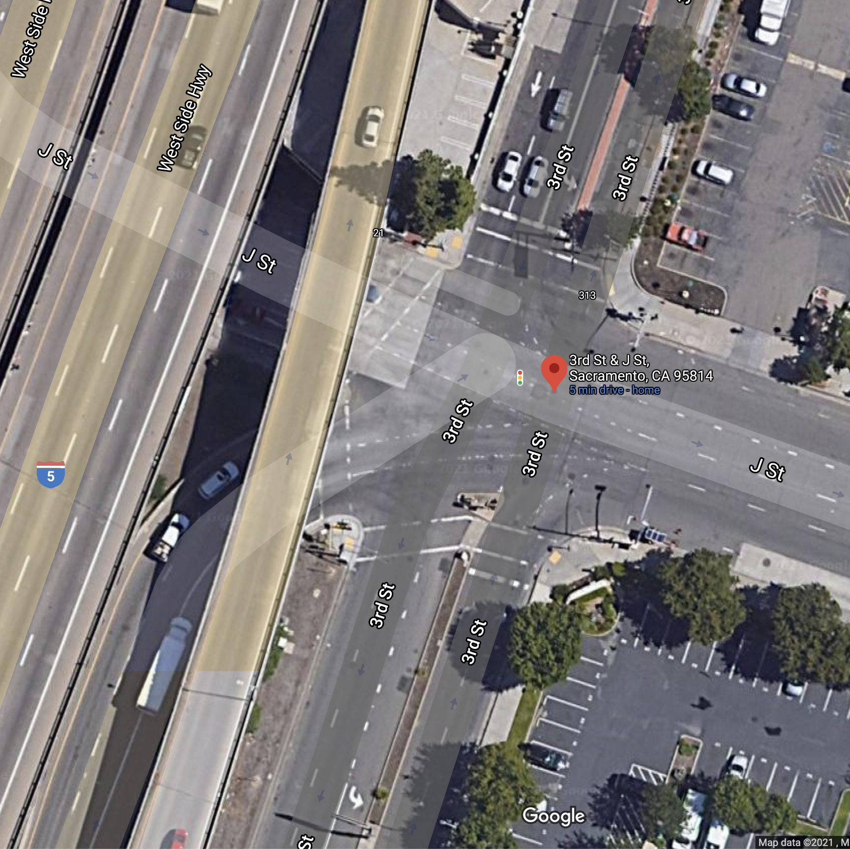
The intersection of 3rd Street and J Street is undergoing construction right now, most of it related to sewer line installation on 3rd Street, but perhaps related to other projects as well. Here is the Google image, not showing the current construction. I thought I had written about this intersection and its pedestrian hostility before, but I can’t find it searching, so it must have been one of those thoughts I never followed through on.
This has always been a problematic intersection. Two freeway off-ramps, coming from I-5 southbound and I-5 northbound, bring high speed drivers onto J Street without causing them to slow much from freeway speeds unless the lights happen to be red. 3rd Street is much calmers but has its own issues.
For a person walking north or south on the east side of 3rd Street, there are five crosswalks to navigate just to cross J Street. You can see in the photo that they are not well maintained, quite faded, low visibility crosswalks that many drivers would not even notice. Each crossing requires pushing a button, and since freeway off-ramp traffic is prioritized, each signal cycle is quite long. (For those counting, the reason I call this five crossings is that the crossing of 3rd Street on the south side had a short pedestrian cycle which was less than required by MUTCD and certainly less than should be available to walkers, so for most people, it had to be crossed in two stages, making for an even longer time to clear the intersection. Of course with no ped button on the median, one the second crossing just has to be done in a gap in traffic, against the signal.)
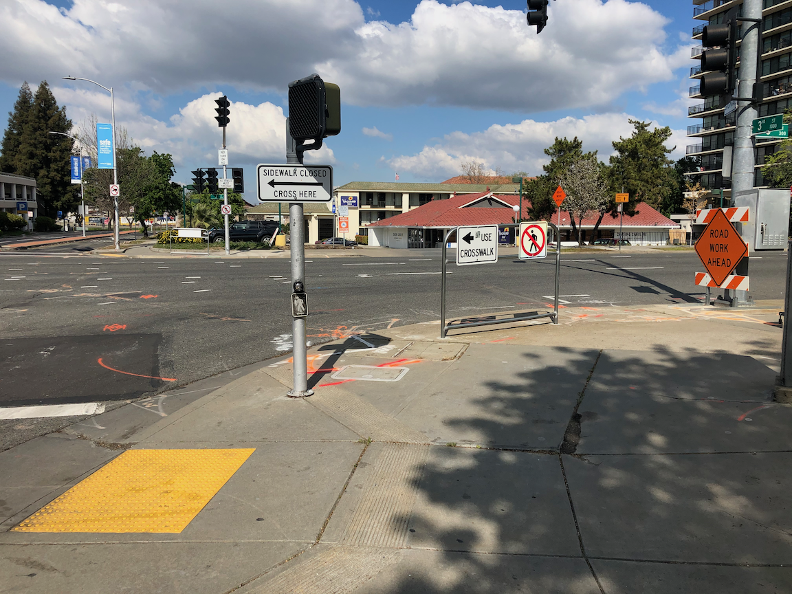
At this time, the intersection cannot be navigated at all. The northwest corner is under construction. Not sure why, as the ramps and curbs there were fairly new, but it is, which of course closes both the crossing of 3rd St and the crossing of the southbound off-ramp to J St. No signing and no barrier is in place on the northeast corner to indicate the closure. Notice that the pedestrian detour signs are still up on this route, even though it is not accessible. Notice also the very poorly designed curb ramp, with a detectable strip that sends walkers/rollers out into J St with its high speed traffic.
3rd St & J St, construction northwest corner, no warning
If on the other hand, you started into this mess on the south side of the intersection, there is no advance warning on the southeast corner that the crosswalk and sidewalk are closed ahead. But if somehow you approached the southwest corner, there is a sign placed in the ramp to prevent you from getting to or from the southwest corner. If there were a sign on this side, you would think there would be a sign and barrier on the southeast corner letting you know. You’d be be wrong.
3rd St & J St, southwest corner, sidewalk closed but no warning
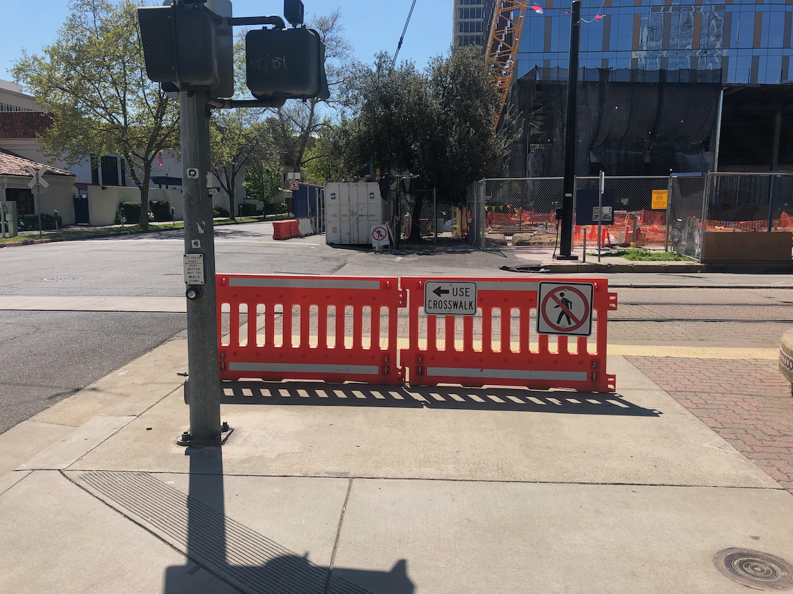
What makes all of this particularly egregious is that pedestrian crossing on the east leg of the intersection is prohibited. See the prohibition signing and barricade on northeast and southeast corners, below.
3rd St & J St, northeast corner, crossing prohibition on east leg3rd St & J St, southeast corner, crossing prohibition on east leg
So, solutions:
First, sign and barricades sidewalks and crosswalks properly. It is well known how to do this, and failure indicates intentional neglect on the part of the construction company, and of the city staff that permits these construction projects.
Second, install a crosswalk over J Street on the east side of the intersection, so that walkers can cross in one quick crossing rather than five slow crossings. Crossing prohibitions are more than 90% of the time an effort by traffic engineers to speed motor vehicle traffic. They rarely have anything to do with safety, and in this case, the prohibition is not there for safety.
This construction project is yet one more of the issue in Sacramento where the city requirements and construction company implementation do not meet ADA requirements, nor MUTCD requirements. These practices create a hostile environment for walkers and bicyclists, and this is no ‘accident’. It is intentional, and it is probably criminal.
Added: I missed a great argument for installing a crosswalk over J Street on the east side. There is no reason for there even to be crosswalks to the west side of 3rd Street, as there are no sidewalks on the west side, to the north or to the south. So if one new crosswalk is installed on the east side, four can be removed, including the ped signals. That should make the traffic engineers salivate!
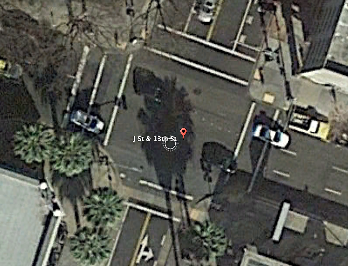
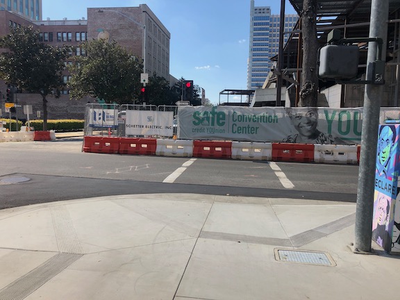
The intersection of 13th Street and J Street in downtown Sacramento is a mess for walkers and bicyclists, largely due to poor decisions that the city has made. The setting is below, with a historical view selected for no leaves on the deciduous trees. On the southeast corner is the convention center, which is under construction now, and the southeast corner is fenced off. On the southwest corner is the Sheraton Grand Hotel. On the northwest corner is a major downtown parking garage, managed by Ace Parking. On the northeast corner is another parking garage managed by Parking.com.
intersection of 13th Street & J Street, downtown Sacramento
In the days before construction on the convention center started and the Sheraton shut down due to the pandemic, this was one of the busiest pedestrian intersections in the central city. The crossing of 7th Street at K Street/DOCO Center, L Street at 11th Street and 10th Street when the legislature is in session, Capitol Mall at Tower Bridge, and a few others are up there, but this one is certainly in the top 10. The city rarely collects pedestrian data, so I do not know what the ranking or volume is.
When the convention center is completed and open, and the Sheraton opens at full scale, this will again become a very busy pedestrian intersection. So you would think that the city would design this intersection and signals to prioritize people walking, but you’d be wrong.
The crossing of J Street on the west leg of the intersection requires pushing the ped button. There are a number of pedestrian signals in the central city that do not require pushing the button, and these are called auto-recall, meaning they automatically change on a cycle. Not this one! I just observed a number of walkers crossing here, and only about 5% of them initially realized they had to push the button. When I mentioned that the signal would never change unless they pushed it, they were surprised, and not happy. When the ped head signal does come on, it has a white hand of 5 seconds, and a countdown of 9 seconds for a total of 14 seconds. There are three lanes of motor vehicle traffic here, lanes about 12 feet wide, for 36 feet. The MUTCD recommended crossing speed is 3.5 feet/second, so 36 feet should be a minimum of 10 seconds, but this assumes that people can leave the curb immediately, not true when the activation button is set well back, and there is pedestrian congestion. In that case, the crossing speed should be 3.0 feet/second. If you want to read about the contortions traffic engineers go through to make walk cycles as short as possible, read pedestrian crossing questions and answers.
The traffic signal for J Street will remain green unless there is a vehicle waiting on 13th Street or someone pushes the ped button to cross. The ped signal to cross 13th Street goes through a white hand, countdown, brief pause, and then back to the next cycle. Without a cross-traffic vehicle or button push, the traffic signal will never cycle. Ever.
crosswalk over J Street at 13th Street
An additional problem is that sometimes the signal controller will just skip the crossing J Street part of the cycle, even when the button is pushed. Since I’m mostly on my bicycle rather than on foot here, I haven’t quite pinned down the behavior. I don’t know if it depends on time of day, or traffic volume, or is just random, but I can affirm that it happens, and not infrequently. So even after the walker presses the button, they may have to wait through another full cycle before they get the walk.
On the southeast corner, the convention center construction has closed the corner and sidewalks. In this situation, there should be a barricade and warning signs on the opposite corner, so J Street south side eastbound and 13th Street east side southbound. A fully sighted person can of course see the barrier and fence across the street, but the point of ADA requirements is to communicate to everyone, not just the sighted. Below is what is looks like, followed by what it should look like. Remember, this is a city project, not a private development, but the city apparently holds itself to lower standards than it holds private developers.
closed crosswalk over 13th Street at J Streetproper barricade and signing for a closed crosswalk, O Street at 8th Street
The east leg crosswalk also suffers from traffic flow design. The walk sign for this crosswalk comes on at the same time as the southbound green signal comes on, bringing drivers into immediate conflict with walkers in the crosswalk. There is no leading pedestrian interval (LPI) to let the walkers get a head start. At this time the crosswalk is closed, but as soon as it is reopened, the conflicts will be immediate, as they have been for years.
Solutions?
Immediately institute auto-recall on the crossing of J Street, and remove the buttons. These are not modern audible buttons, they are antiques.
Immediately institute a leading pedestrian interval on the crossing of J Street, to increase protection from left and right turning drivers.
Immediately lengthen the pedestrian phase for the crossing of J Street to a minimum of 20 seconds.
When then southeast corner of the intersection is re-opened, with completion of the convention center construction, implement an exclusive pedestrian phase for this intersection, in which there is no movement by motor vehicles during the walk cycle, and walkers can cross in any direction including diagonally. If any intersection in Sacramento deserves this treatment, this is it.
Traffic calm J Street to reduce speeds. The most important step is to reduce general purpose lanes to two, and create some sort of bicycle facility. I’m not sure of the best design, as the valet/unloading/loading are for Sheraton Grand may make this challenging.
Get rid of any City of Sacramento Public Works employee who believes the purpose of central city streets is to favor suburban commuters (the J Street traffic) over walkers, bicyclist, and local residents.
I have made at least seven 311 reports on the signal problems at this intersection, asking that it be changed. The only change that I’ve been able to notice is that they lengthened the pedestrian phase for crossing 13th Street, and shortened it for crossing J Street. I just gave up after a while.
Bicyclists
That covers most of the pedestrian problems at this intersection. How about bicyclists? 13th Street is a major bicycle route in downtown, being the only north-south street that crosses through Capitol Park and is not an arterial street, often with heavy traffic and higher speeds. There are bike lanes on much though not all of 13th Street to the south J Street, and there are bike lanes on most blocks to the north, except the half block approaching this intersection. Here, the bike lane has been sacrificed to create a turn lane. There is a required left turn lane and an optional turn lane, but no bike lane. So at this busiest of all intersections on the route, there is no bike lane. There is a clear message here from the city: we will accommodate bicyclists only if it does not reduce motor vehicle capacity. Otherwise, tough luck.
The loop detectors on 13th Street only sometimes detect bicycles. I often see bicyclists during off-times, when there are fewer motor vehicles to trigger the cycle, proceeding through the intersection on red, when it is safe to do so (and occasionally when it is not). They have the right to do so, since by definition a signal that does not detect vehicles (devices) is a non-functional signal, but it is not the best solution.
When the pedestrian button is pushed to cross J Street on the west leg, but no southbound motor vehicles are present, the vehicle signal remains red, so doesn’t allow for undetected bicyclists. This doesn’t protect any walkers, so it makes not sense.
Solutions?
Continue the bike lane on southbound 13th Street to and through (with green skip paint) the intersection with J Street, and remove the left turn lane which prevents the bike lane from continuing. That might mean lengthening the green light for motor vehicles in order to clear the queue.
Install video detection on this intersection that will detect bicyclists on 13th Street so that they don’t have to wait for motor vehicle traffic to arrive and trigger the signal cycle.
Change the traffic signal for southbound to go green at the same time as the pedestrian walk sign. This allows bicyclists to proceed without confusion.
I wrote some while ago about leading pedestrian indicator (LPI) signals, which give the pedestrian a head start of a few seconds before the parallel traffic light turns green. So far as I know, Sacramento has not added any locations to the list of eleven.
But the city should. In fact, I’d argue that any traffic signal where there are a significant number of walkers, and a significant number of turning drivers, should have an LPI. Drivers often fail to yield to people in the crosswalk when turning, or cut in right behind them, and the more chance the walker has to get out into the crosswalk and visible, the better. Of course nothing about the LPI prevents the driver from turning on red, unless turns on red are prohibited. Prohibiting turns on red has been much discussed lately, but I don’t think that treatment is the most important that can happen at intersections.
I live a few blocks from Fremont Park, which is the block between 15th Street and 16th Street, and P Street and Q Street. In fact, many of the parks in the central city are located between pairs of one-way streets, called couplets. 16th is one of the busiest streets in the central city, and the other two are moderately busy, and these four intersections see a lot of turning vehicles. Since I walk nearly every day to and around the park, I get plenty of chance to see how drivers interact with walkers in the crosswalk. I’ve never seen anybody hit, but I often see conflicts, the driver trying to intimidate the walker, trying to beat them to the crosswalk, stopping just short of hitting them, or cutting in close behind them.
P Street and Q Street are two-lane arterials, while 15th Street and 16th Street are three-lane arterials, with higher traffic volumes and vehicle speeds. 16th was a state highway.
So, I’m asking the city to install LPI signals for the south crosswalk at 15th & P, the east crosswalk at 15th & Q, the north crosswalk at 16th & Q, and the west crosswalk at 16th & P. The photos below show the intersection of 15th & P from pedestrian level, and overhead. The video shows two pedestrians crossing, and mostly through the crosswalk before the driver encroaches. This was a low traffic time with only one turning vehicle. When I have a chance to capture a heavier traffic time with pedestrians, I’ll replace it.
P Street westbound, showing crosswalk over 15th St ahead15th Street & P Street, south crosswalk
crosswalk over 15th Street at P Street
I often write about the Sacramento central city because that is where I live, and I have ample opportunity to observe transportation infrastructure and driver, walker and bicyclist behavior. However, I’d like to state that I DO NOT think that central city issues should be solved first. These issues occur in many places in Sacramento, where the traffic is higher speed, facilities are poorer, and neighborhoods have been disinvested. Drivers in the central city are just as bad as drivers elsewhere, in fact most of them are from elsewhere, the suburbs, but they have grown somewhat accustomed to seeing walkers and bicyclists, and are more careful around them.
The convention center and community center theater project (3C) project did a very poor job of preserving access for walkers and bicyclists at the beginning. Some issues have been resolved, but some never have, though the project has now been going on for just less than two years.
The most significant issue is that there was no provision made for northbound bicyclists on 13th Street, passing the construction between L Street and J Street. 13th is a major bicyclist route of travel, and the city knew this before the construction started. But the original traffic plan did not address this use at all. After public complaints, a sign was installed on the sidewalk for northbound bicyclists, photo below, but not the southbound. The numerous walkers using this sidewalk, adjacent to the Marriott and Sheraton convention facilities, were confused to see bicyclists on the crowded sidewalk. After more public complaints, a sign was added southbound, the second photo, though it is placed in a location where people coming from K Street would not necessarily see it. As you can see in the first photo, the sidewalk is narrow just north of the crosswalk, so bicyclists heading north are brought into immediate conflict with pedestrians heading south, many of whom are headed to the crosswalk over L Street. Of course having an angled ADA ramp here, rather than the two-to-a-corner design that should be used wherever there is significant pedestrian traffic, makes things worse.
Of course the best solution here would have been to just close 13th Street to motor vehicles between K Street and L Street, leaving the narrowed roadway available for two-way bicyclist traffic. There are far more bicyclists using this route than private vehicle drivers. Despite that, the city biased in favor of drivers.
13th Street northbound at L Street13th Street southbound at K Street
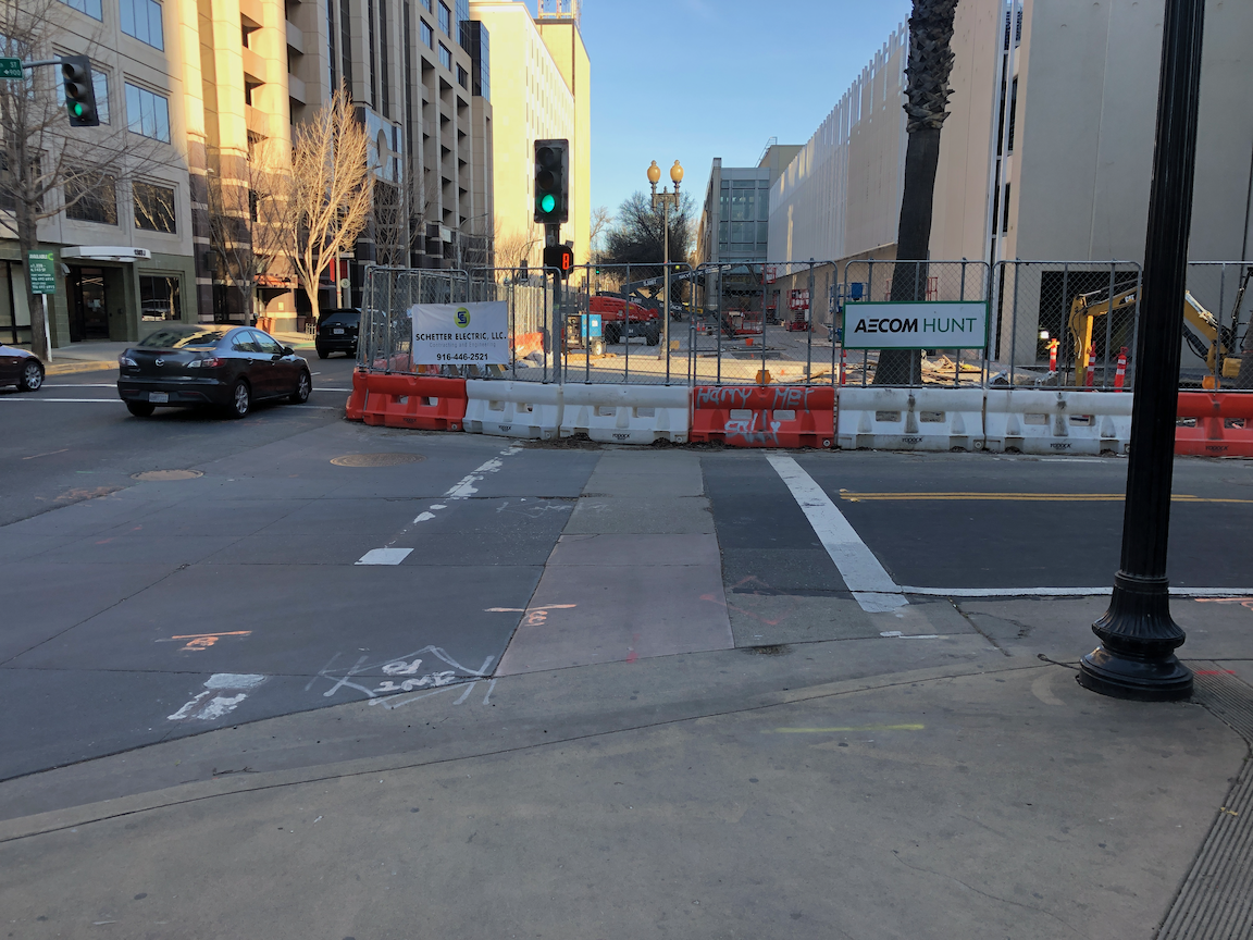
One issue on which progress was made was the southeast corner of J Street and 13th Street. Initially this corner was closed, giving walkers only one choice of how to cross, despite this being one of the most heavily used intersection crossings in the city. There was no reason to close the corner off, the area behind the fence was never used for construction. After about a year and a half, the corner was re-opened, photo below, so that walkers have a choice of routes. Note that when the city finally worked on this corner, the work was not done behind the fence, but the fence was moved and then the sidewalk and ramp work done by closing off the corner until it was done.
J Street & 13th Street, southeast corner, finally re-opened
On the east side of the project, issues remain. The sidewalk from J Street south along 15th Street has no signing indicating that it is closed ahead, see photo. When you get half way, there is just a fence blocking access. In daylight, you can see the fence ahead, but a limited vision person and anyone walking at night would not see the fence until they got to it. This is simply unacceptable.
15th Street west side, southbound from J Street, no signage
There are several other less serious issues around the east and south sides. At K Street & 15th Street, there is no signing to indicate how to get to the other side, to go either northbound or southbound. This one is not hard to figure out, at least for sighted people, but it was still not done correctly. This crosswalk ramp should have been barriered off, just like the ADA compliant barriers in the previous post, since it only leads to a closed crosswalk.
On the south side of the project, there are plastic barriers for the crosswalk over 14th Street at L Street, and for the crosswalk over L Street on the west side of 14th Street. These barriers were knocked over months ago and have not been put up again. There were not sufficient to begin with, but laying down on the ground, are both useless and hazardous.
14th Street at L Street, failed barrierL Street at 14th Street, west side crosswalk, failed barrier
I’m going to call this one a failure on the part of both the construction company and the city: the construction company for failing to monitor and maintain the traffic control devices for which they are legally responsible, and the city for failing to monitor the construction company. Blame all around!
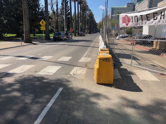
And lastly, the closure of a lane on L Street for the construction was not handled well. As you can see, there is a narrow crosshatched area the length of the block. One might reasonable choose not to go this way, but then again I see people going this way every day, both walking and bicycling. I am not sure how this should have been handled, but there must be a better solution. Of course one solution would have been to continue a temporary pedestrian walkway on the north side of the street, set off by concrete barricade, and requiring only a simple fence to separate the walkway from the construction site. If more street width was required, parking could have been removed from the south side and the general purpose lanes shifted to the left. Note there there never was a bicycle lane present in this block, it is dropped at 15th Street and the traffic sewer 3-lane roadway continues west.
L Street westbound at 14th Street, narrow shoulder
In closing, this construction project is probably the worst in the city (though there is competition). It does not involve a private property owner, it does not involve a state construction project, it is a city project on city land. There is simply no excuse for such poor walker and bicyclist accommodation. It is a big middle finger to those to who don’t drive.
Since there will likely be a long string of posts on construction zones done wrong, I want to point out that they can be done right. This is one from yesterday. Though the crosswalk closure here was less than one day, it was signed properly, and the detour was very short, about 30 feet west to the next crosswalk.
N Street at 12th, clear construction zone signingN Street at 12th, clear detour signing
This is the second in a series of posts on a Walkable Sacramento, starting with crosswalk policies.
Crosswalks
All prohibited crossing locations will be evaluated within two years, and every instance that is not clearly justified will be removed. Locations were infrastructure change is required to accomplish safety will be prioritized for funding and resolved within five years.
No crosswalk will be removed without approval of the Active Transportation Commission and the city council.
All crosswalk locations with more than 200 crossings per day will have marked high visibility crosswalks, within five years.
All intersections with more than 2000 crossings per day will receive an exclusive pedestrian phase, within three years.
Marked and safe crosswalks will be provided on all roadways at no less than an 1/8 mile interval, within two years. Pending the installation of safety countermeasures, speed limits will be reduced. Modify ‘complete streets’ policies so that they address this interval of safe crossings, and do not construct ‘complete streets’ that fall short.
All marked crosswalks will be daylighted in the upstream direction with red curb markings and removal of marked parking, within five years, with a goal of 20% per year. All unmarked crosswalks will be daylighted within ten years, with a goal of 10% per year. (Daylighting means to remove the parking space closest to the crosswalk, so that walkers may better see vehicles, and drivers better see pedestrians. Sometimes this daylighted area receives a painted or concrete curb extension.)
All crosswalks with at least 2000 crossings per day will receive curb extensions where parking lanes are present, within eight years.
Raised crosswalks or raised intersections will be installed at any intersection where serious injury and fatality occurs after other measures have been taken.
Roadway crossing distances will be limited to no more than 60 feet. Where wider roadways exist, median refuge islands with pedestrian activation buttons will be installed to reduce distances to 40 feet or less, within five years.
No roads will be constructed that are more than two lanes in each direction, and all roads with more than two lanes will be reallocated within ten years, with the purpose being to reduce crossing distance. Freeways and expressways with strictly limited access may have more lanes.