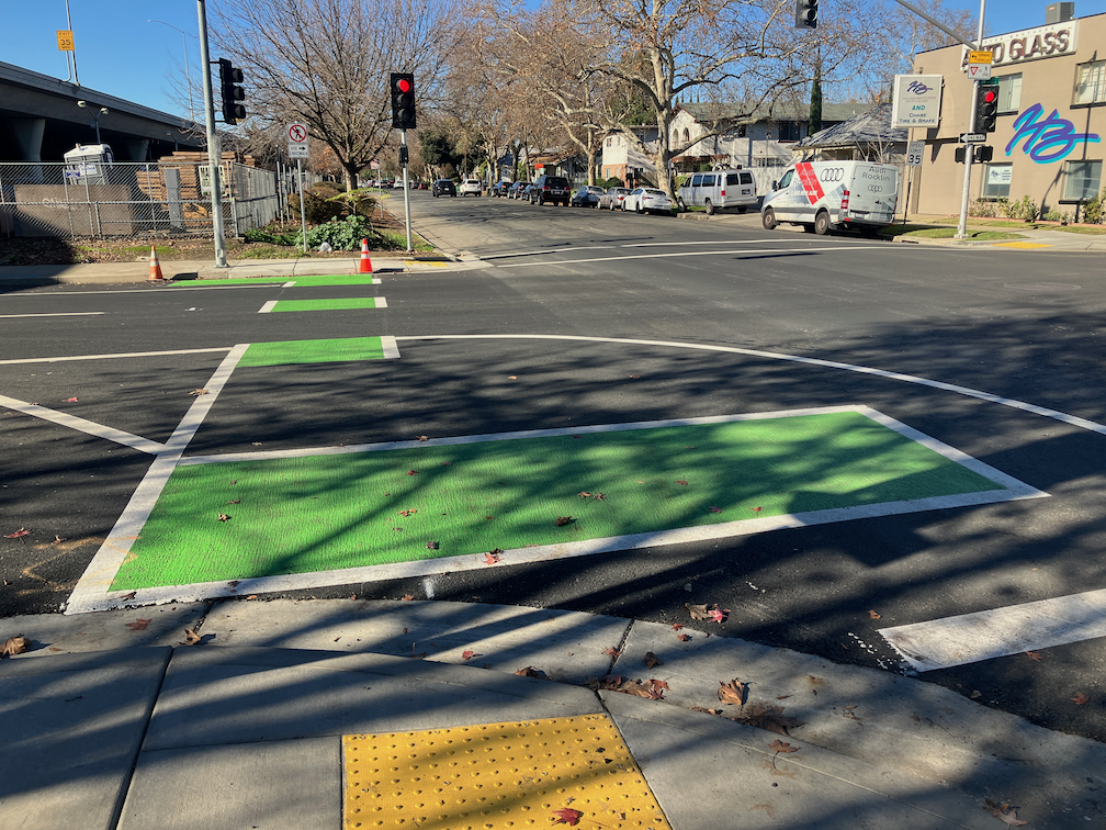
The 19th Street bikeway has been completed from W Street to Broadway. Only a half block of the two blocks is separated bikeway, and it is on the right side rather than left side as it is to the north. At W Street there is a bike box in line with the bikeway to the north, and a green dashed bikeway to carry the bikeway from the left or east side to the right or west side. The curved area shown in the photo does not have any sort of protection to reduce turn speeds, as is present on most turn wedges in the rest of the Central City Mobility Project.
The turn intersection involves a two stage turn for bicyclists, once to cross W Street to the south side, and then to cross 19th Street to the west side. There is no separate bicycle phase or bicycle signal face here. The pedestrian crossing phohibition here and lack of crosswalk indicates two things: there is no sidewalk on the south or freeway side of W Street, and that high speed turns from W Street to 19th Street are expected and encouraged. This project would have been a great time to add a crosswalk and pedestrian signaling here, and remove the prohibition, as both sides of 19th Street under the freeway have sidewalks, so a crosswalk would speed travel for walkers by offering two routes of travel. Bicyclists using the green dashed crossing of 19th Street have turning traffic at their back, which is somewhat unsafe but could have been made safer with an exclusive bicyclist phase or even a bicyclist signal phase. Since the signal timing favors W Street over 19th Street, it could have been possible to allow both a brief bicyclist phase and a turning phase.
19th St bikeway transition to right side
Crossing under the freeway, the bikeway is partly green painted and next to a travel lane, and partly parking protected bikeway to X Street. From X Street to Broadway, it is a regular door-zone bike lane. At Broadway, there a green bike box the full width of the street, allowing bicyclists to continue straight or turn left onto Broadway.
To summarize, the design is OK but could have been better.
The white line stripes that were added to the two blocks of P Street protected bikeway, 19th Street to 17th Street, are an attempt to keep leaf piles and trash cans out of the bikeway. I noted the added white stripes in Central City Mobility update #27, but wasn’t sure why they were added. The wording was added later. I have not yet observed this location on either a trash pickup day, or now that there are a lot more leaf piles. I have not seen the striping and marking on other blocks of the new bikeways, so this may be a pilot to see if it works. The practice of putting leaf piles in the regular Class 2 bike lanes in common, and the city has made no effort to reduce this practice.
I have written before about excess signals in the central city: too many traffic signals?. The fact that these exist is bad enough, but as part of the 5th Street conversion project, one-way to two-way, the city is replacing unnecessary old signals with very expensive and unnecessary new signals.
At 5th Street and S Street, a new signal is being installed. S Street is a low volume street that never needed and never should have had a traffic signal. A four-way stop sign, maybe, or maybe only stop signs for S Street. A fully signalized intersection, no way. There is nothing wrong with the existing signal for northbound traffic. Of course, a new signal is needed for southbound traffic. But the city is replacing northbound. Why?
Why is the city putting in a new signal here? Because there was one here before. If this intersection were studied for whether it needed a signal, the answer would be no. A warrant is a study indicating a need for a signal, as is simply explained at http://www.apsguide.org/chapter3_mutcd.cfm (this is much easier to read than the MUTCD). The 5th Street & S Street intersection does not meet any of these criteria. So, the city is putting in a new signal because they want to, not because it is necessary.
new and unnecessary signal at 5th St & S St
The current cost of a fully signalized intersection is $200K to $500K. Half a mil per. Your tax money. For intersections like 5th Street and P Street, a signal probably is necessary, particularly since the P Street and Q Street traffic sewers encourage high speeds.
It is likely that the signal at T Street is similarly unnecessary, however, T Street is busier than S Street, so might be justified by traffic volume. I’d like to see the city do a new traffic warrant study on this intersection. The city always uses warrants as an excuse for something it does not want to do, but seems to ignore these for things it wants to do. A typical traffic engineering misuse of MUTCD guidance.
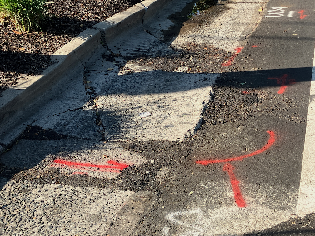
I have mentioned the problems with the gutter pan on several blocks of the new bikeway on 19th Street being so deteriorated that the effective width of the bikeway is only about two feet. It is clear that the city did not look at the existing conditions of the gutter before deciding to place the bikeway in this gutter. But, this is not an easy thing to fix. There are at least four blocks that are unacceptable, but it will probably require reconstruction of the gutter pan to fix it.
What can be fixed, but has not been, is the root heave in the 19th Street bikeway at Matsui Alley (note that Matsui is discontinuous, and is present only on the west side of 19th Street; the alley does not exist on the east side.) The photo below shows the root heave, but doesn’t really emphasize how big it is. There is a four inch displacement. This is a pavement flaw that could easily cause a bicyclist to crash. I don’t know whether the orange paint marking is from the city or bicyclists, but orange paint is not visible at night, and even in daytime it doesn’t make clear what the rider should do to avoid the hazard.
19th St bikeway at Matsui Alley root heave
I have reported this issue to the city 311 app several times. I know of at least two other bicyclists who have reported it multiple times. The city 311 incident map shows only my latest report (230805-1907594), which means that the city has closed all the other reports without any action.
Allowing this type of hazard to exist, when it is a known hazard, particularly in a location designed to attract bicyclists, is criminally negligent. Let me repeat that for the idiots in Public Works, who seem to be hard of hearing – CRIMINALLY NEGLIGENT.
If you are a bicyclist who is using 19th Street, I encourage you to NOT use the bikeway in this block between Capitol Avenue and N Street. Ride in the middle of the general purpose travel lane instead. And if you have the time, file a 311 report on the hazard. It will become increasingly difficult for the city to claim it didn’t know about this problem (by closing the reports without action), the more people report it.
Flexible delineators have been installed along part of 21st Street, and are undergoing active installation this week. These K-71 posts are more substantial that the traditional vertical delineators. They can still be run over, and are run over, but since they look more substantial, drivers are less likely to run over them. They are still plastic, so provide no actual protection from errant motor vehicles; only hard curbs or true bollards (steel or concrete) can do that, but still, an improvement over earlier designs.
Central City Mobility Project, 21st St, K71 delineators
I don’t know how quickly the otherwise completed sections of the Central City Mobility Project will have these delineators installed. Apparently there is a US-wide shortage of materials for separated bikeways, and many cities are not able to complete their projects.
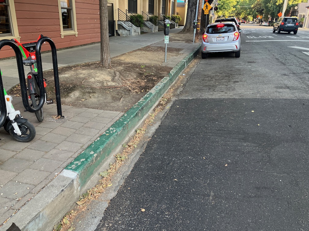
A second change since my last posting is that some parking spot paint is showing up. I had thought that parts of the striping that were still missing after quite some while were just missed, but in fact at least some of them were intended for parking regulation marking. The photo below shows a yellow curb and yellow stripe adjacent to the parking spots. I am glad to see that both the curb and the parking lane are being marked with paint. Otherwise, many drivers would fail to see, or pretend not to see, the curb color alone. This is hard to miss!
Central City Mobility Project, 21st St, yellow curb and parking marking
In California, painted curbs have the following meaning:
red – no stopping, standing, or parking
yellow – commercial loading and unloading (can also be used for passenger loading and unloading, unless otherwise signed)
white – passenger loading and unloading
green – limited time parking, as posted on a sign or the curb
blue – disabled parking (must have a license plate or temporary hanger tag)
In Sacramento, and many places in California, parking enforcement takes a laissez faire attitude towards curb colors. Except for red curbs, they are seldom enforced, and even red curb enforcement is uneven. Note that red curbs are really intended to mean what they say. If you stop there, you are in violation. A typical driver excuse for any parking violation is that they were ‘just going in for a moment’. Moments turn into minutes turn into hours, as I have observed many, many times. If you get out of your car, you are parking, no matter what the driver calls it, the law calls it parking. Parking on white and yellow curbs is a violation. Obviously commercial loading and unloading may take some time, but if there is no active loading or unloading going on, that is a violation.
I like green curbs as a solution for businesses where people pick up food and beverages. Fast food places where people order ahead. Coffee shops. My local coffee shop has a green curb right outside, and it is used for its intended purpose by some drivers. Other drivers just take it as an open free parking spot. I have reported these to city 311 as violations, but the city has not enforced so far as I am aware. More green curbs, please! (note that in the photo, the motor vehicle had just pulled into the curb, and the driver was crossing the street to pick up food at one of the businesses on the west side of 15th St; the parking meters are not functional, but the 15 minute limit is clearly posted)
green curb 15 minute parking, 15th St, Naked Lounge
Because past enforcement has been laissez faire, it will take some signing and education to make these curb colors work. Most drivers in California don’t really understand curb colors; I used to work in Nevada, and I can tell you most drivers there know exactly what they mean.
I am very pleased to see that curb colors are being more actively used in the city. Illegal parking endangers bicyclists, in particular, but also walkers and drivers. Of course something must be done to get delivery vehicles out of bike lanes and out of blocking streets and crosswalks. The city is far, far from having a plan to address that.
Other
19th St: no active work south of Q St
10th St: street being prepared for repaving and re-striping
I St: street being prepared for repaving and re-striping
5th St, 9th St: no active work
Nothing has been installed in the ‘turn wedges of death‘. I looked at the detailed design for these turn wedges (another advocate was able to obtain them), and it is still not clear what is intended for these locations. The bicycle signal at 21st and H Sts has not been installed, nor is there any sign cautioning bicyclist from using the pedestrian signal, which exposes them to high speed left turning motor vehicles.
A post today on Streetsblog LA (Santa Monica’s New 17th Street Curb-Protected Bike Lanes are Amazing) is about new bicycle facilities on 17th Street in Santa Monica. I think you will find some of the photos interesting. At first glance, it looks like some of the ones being installed as part of the Central City Mobility Project, but looking more closely, two differences really stand out. Most of the separated bikeways in Santa Monica are curb-protected. Bikeways that are solely parking protected only are protected when cars are parked. Otherwise, they are really just buffered bike lanes. And the turn wedges are hard curbs with additional markers, not paint-only, and definitely superior to the Sacramento’s suggested turn wedges which might have vertical delineators or other markers, but won’t have curbs.
curb turn wedges in Santa Monica (from Streetsblog LA)
To illustrate the problem these curb turn wedges solve, see the photo below of a motor vehicle making a high speed dangerous turn over a painted parking wedge at P Street and 15th Street.
16th St & P St, Sacramento, high speed turn across painted turn wedge
Other
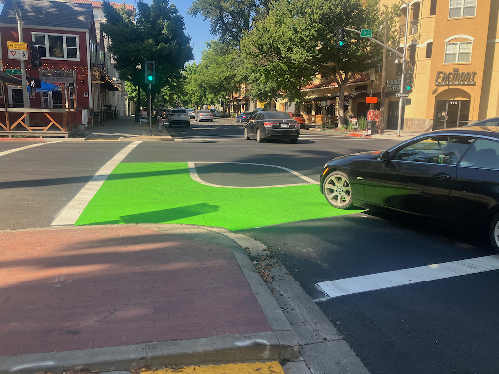
P Street markings including green paint are nearly complete. In two blocks, the green paint is nearly the entire block, for unknown reasons. There is nothing unique about these blocks. While green paint is useful to mark conflict areas, excessive use will just lead to maintenance expense over time.
Q Street has preliminary markings, but the temporary lane tabs still indicate overly wide and dangerous general purpose lanes.
19th Street is nearly complete from H Street to Q Street, but there is no marking south of Q Street. South of Q Street, the old bike lanes show in some places, but otherwise have been erased in favor of overly wide and dangerous general purpose lanes. Several blocks of the new bikeway are in the gutter pan, making an unacceptable rough and dangerous surface.
21st Street is complete except for a few spots that were missed and have not been picked up. The confusing arrow at 21st Street and W Street has been corrected. There is still accommodation or signal for bicyclists at 21st Street and I Street.
I Street work has begun, with the last few ADA ramps complete and some repaving.
10th Street has the last few ADA ramps complete.
9th Street doesn’t have any work in evidence.
5th Street has not progresses past installation of signal bases.
Overall, no vertical delineators have been installed at any locations.
Delivery vehicles are parking in and blocking the separated bikeway on P Street approaching 16th Street. The city did not mark any of the parking spaces for delivery use. Cones and barricades have been placed in the buffer to reduce this hazardous driver behavior, and have been removed by someone, and replaced by citizens, and removed by someone, and …
On Wednesday afternoon, the sign below was on 21st Street approaching I Street. The sign was not there on Tuesday morning. If a bicycle signal was intended at this intersection in the design, why was it not signed earlier? Why wasn’t the signal already installed, since there was signal communications infrastructure installed at this intersection several weeks ago? Or was this a design oversight that the city decided to fix after being called out on it? And when is ‘coming soon’?
21st St at I St, sign for future bicycle signal
I observed bicyclist behavior at this location for a while on Tuesday. Every single bicyclist who was headed north on 21st Street crossed against the red light, so as to not be hit by left turning drivers who generally do not yield to anyone in the crosswalk, and then onto the sidewalk on the west side of the street, continuing through the area at Old Soul Weatherstone which is congested with tables and walkers. So the city has trained bicyclist to ride on the sidewalk. Those who have been so trained will be likely to continue sidewalk riding even after installation of the signal. Ouch!
Useless Turn Wedges
I have ridden 21st Street a number of times, to see how the project is progressing and to see how drivers are responding to the new layout. Most drivers are parking correctly in the parking that provides parking-protection for the bikeway, but a few continue to park against the curb. I’ve reported these to 311 for parking enforcement, but of course as always, parking enforcement reports that the vehicle is no longer there, whether it is or not.
Several times in a row drivers have turned across my path at high speed, left from 21st Street to L Street, over the green paint and the white turn wedge paint. At the times of day I was there, there were few to no parked cars, so I was clearly visible to the drivers, not in any way hidden. In both cases I had to slam on my brakes to avoid being hit by the drivers. They did not slow. The turn wedge diagram provided on the Central City Mobility Project page, shown below, clearly shows bumps and posts (vertical delineators) in the wedge. Without more detail, I can’t say whether these will actually affect driver behavior, but in general only hard curbs or real bollards (steel or concrete) actually affect driver behavior. In the meanwhile, drivers are being trained to turn across bicyclists, with impunity, and will not likely change their behavior when and if something is installed in the turn wedges.
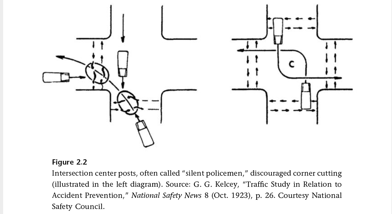
I have been reading Fighting Traffic by Peter Norton, and in Chapter 2 he introduces the concept of the outside left turn, which worked to prevent drivers from cutting the corner on left turns, and was later enforced with ‘silent policemen’, hard structures that provided serious consequences for drivers who insisted on cutting corners. Later, when motor vehicles were given dominance on the roadway, these were removed. It is time to bring these back!
Other
Striping and green paint is very nearly complete on 21st Street. 19th Street has been repaved and preliminary marking installed (the dashed white lines). P Street was just stripped for new pavement (I’m not sure what this process is called, removing 2 to 3 inches of old pavement so that new pavement can be laid), and is being repaved today (Thursday). Q Street has been patched but not stripped. I’m not noticing any active work on I Street, 5th Street, 9th Street, or 10th Street, though I Street has had ‘no parking’ signs up for some while.
The repaving is being done to the full width of the roadway, including the parking lane. This is a waste of materials and money. The parking lane does not need to be repaved, except in a few circumstances where it has been damaged. Nor does it need to be paved to the same standards as the general purpose travel lanes, which receive far more traffic and wear and tear. But the city loves pavement, and loves to add on unnecessary work to projects, ensuring that less is left for actual improvements to the street that would help walkers and bicyclists.
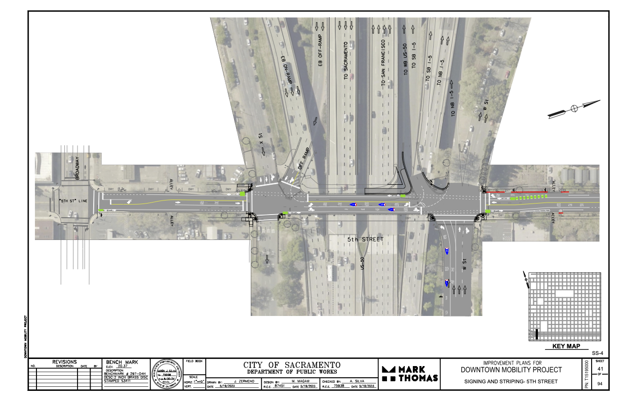
I had earlier expressed concern and lack of information about where the 5th Street one-way to two-way conversion will be handled where 5th Street passes under Hwy 50. (Yes, I know, that this is technically not Hwy 50, but everyone thinks it is, so…)
The following diagram was provided the the city and design firm (pdf). The configuration looks workable, and it probably not any less safe than the current mess. The merging of the two on-ramps into one narrower entrance will probably help to slow traffic entering the freeway, making 5th Street a bit safer. Same with the narrowing of the off-ramp. The curb line will need to be moved in a few locations to accommodate the entire street width with bike lanes, but the curbs here are already quite deteriorated, so that work would be needed in any case. It is not clear from the diagram whether the missing sidewalks in the block between Broadway and X Street will be corrected.
One of the elements of the Central City Mobility Project is the conversion of 5th Street from a one-way, two-lane street, to a two-way, one-lane each direction street. Some work is underway: wiring and signal bases have been installed for the signals necessary for two way traffic at the existing signal locations. Looking at the bases, photo below, I’m guessing that there will be new signal poles and mast arms, not re-use of the existing signals equipment. That seems like a waste of money to me, but the city loves to spend money on new signals, and signal controllers.
I am not sure that many of the current signal locations are even needed. After the conversion, 5th Street will be a lower speed and probably lower volume street. Four-way stops at some major cross streets (such as T Street) might work just fine. Again, the city loves to spend money on signals, and already has unneeded signals at a number of locations (too many traffic signals?).
5th St and T St new signal base
The Central City Mobility Project map shows the 5th Street conversion as extending from Broadway to I Street. The block between Broadway and X Street is already two-way, as are the two blocks between L Street and J Street (the DOCO underpass). It is also two-way north of I Street.
I wonder what, if anything, will be done for the block between X Street and W Street, under the Hwy 50 freeway. This is a very complex block, with a freeway onramp west of 5th Street and a freeway offramp west of 5th Street. The onramp and off-ramp have separate signal phases from X Street and W Street. Traffic westbound onto the ramp, if it makes the green light, is already traveling at freeway speeds, about 65 mph as it crosses 5th Street. Similarly, but not as egregious, the off-ramp traffic, if it makes the green light, is traveling a bit below freeway speeds. I am really not sure how this complex situation can be made safe for bicyclists. Northbound bicyclists only have to deal with drivers running the red light at 5th Street from W Street, but southbound bicyclists would have to deal with multiple turning vehicle movements. In general, the only way to make complex situations like this safe is to have exclusive bicycle phases in which only bicyclists and walkers are moving, no vehicle movement or turns are permitted. But the city is very unlikely to select that safe alternative because it would lengthen the signal cycles and therefore slow motor vehicle traffic to some degree. The city doesn’t want to slow motor vehicle traffic.
The diagram below, from Google Maps, indicates the complexity of this block, but the reality on the ground is even worse.
So the neglect of the Central City Mobility Project for fixing these two blocks of I Street is disturbing. Of the people riding on I Street anywhere west of 16 Street, probably 50% are going to Sacramento Valley Station. But if you spend time on I Street looking for bicyclists, you won’t see many. The average bicyclist won’t ride on I Street. They are uncomfortable with the volume and speed of motor vehicle traffic, but more importantly, they are scared to death of these two one-block sections with only sharrows. So they drive to, or have someone drop them off at, the station. Sacramento Valley Station is the most important transit hub in the city, in the county, and in Northern California outside of the Bay Area, yet the city has neglected access to the station.
The TIRCP grant for improvements at Sacramento Valley Station may improve access from the station on H Street, but again, that is not a near term project, and it is not clear how effective it will be. Probably 80% of the riders on H Street are coming from the station. (Sac kill those sharrows on H St, H St bicycle fixes)
My observation of bicyclist numbers and destinations is based on observation and talking to some riders. It would be nice if the data were available, but I don’t have it, and apparently the city doesn’t have it, or at least has never shared it publicly. I know that the city purchased cell phone data several years ago that would have allowed them to see bicyclist patterns, but so far as I know, they only used it for motor vehicle drivers patterns.
I St shadows between 10th St and 9th St, Sacramento