Sacramento bike share update

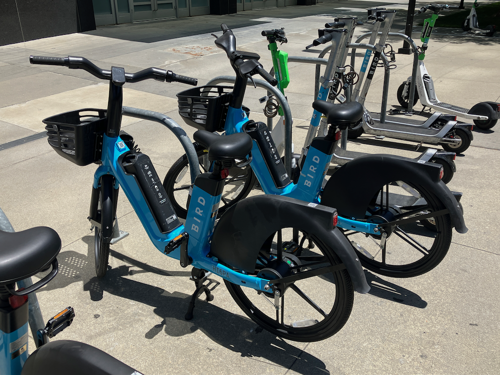
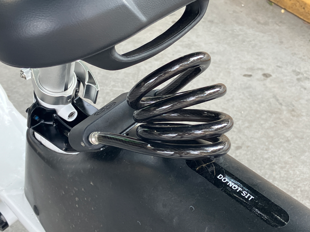
There are a number of new white and green Lime bikes on the street in Sacramento. There are not the easy-to-steal white and green ones of a few months ago, some of which were promptly stolen and the others quickly pulled from service. Though they still seem to be called Gen 4 bikes, they now have a cable lock very similar to those used on scooters. I have seen more of these bikes downtown/midtown than elsewhere. See photo.

Lime bike cable lock

There continue to be red JUMP/Lime bikes on the street. I had the impression that there were fewer of these bikes than there used to be, but it may be that they are just being distributed differently. I’ve seen racks (the old SoBi/JUMP racks) full of these bikes, which had not had more than one or two bikes since the return of bike share. Lime does not make its GBFS (General Bikeshare Feed Specification) available to the public, nor does it have a map of bike share other than in the app, so it is difficult to say whether the bikes are being appropriately distributed/balanced.

While looking to see if there was a web map, I ran across an interesting ArcGIS Story Map from the City of Sacramento, Shared-Rideables in Sacramento. It was created in January 2022, and has not been updated, but is quite interesting.

Lime still seems to be failing to track and pick up dead bikes. By dead, I mean that the battery has run down to the point that it no longer powers the GPS unit, so Lime loses track of where these bike are. Several months ago there were a number of these bikes, reported to both Lime and the city, but not picked up after three weeks. Lime promised to me and to the city to do better. However, recently there were two bikes parked on the pathway from Sacramento Valley Station to the platforms for more than five days. Bike parked anywhere other than in very visible location on the street network do not get picked up for significant periods of time.

I used a Lime bike (white and green) Saturday without incident, returning from a trip. But on my outbound trip, using Lime/JUMP bikes, when I was on a tight schedule, I had no luck finding a bike that worked properly. The first one was stuck in first gear. The second had no pedal assist. The third had a jammed seat post that could not be adjusted. I managed to make the train on time, but barely. The bikes are simply not being maintained as they should be. I have noticed that if I report a problem, though the app, the bike is still there days later, and still rentable by another victim.

When reporting a bike problem, the app provides a limited number of issues (below), and no longer provides a text field for entering detail. The diagram says pedals, but there is no indication here or anywhere whether than means a problem with the pedals or cranks, or means problem with the pedal assist.

Lime app, problem report screen

One feature that was added to the app a few months ago that I really like is that the user can select scooters only, or bikes only, or both, for map display.

The app seems to show whether the bike in question is one of the new white and green ones or the older red Lime/JUMP bikes with the fabric covered locking cable. I’ve said before and will say again that it was a mistake for JUMP to drop the U-bar lock mechanism used on the SoBi and early JUMP bikes. So far as I know, a properly locked bike with U- bar was never was stolen.

car sickness on Capitol Ave

I walked by the section of Capitol Ave in Sacramento, east of 18th St, as I have done many times, but today it struck me how dead this street is, now. It was alive for a while:

Capitol Ave, Sacramento, pandemic street closure, August 2020

But now it is sick again. To extend the analogy, it has always suffered from car sickness (a street dominated by motor vehicles), but had a relatively brief recovery when the street was closed to cars and opened to people walking and bicycling, and now a relapse into car sickness:

Capitol Avenue, Sacramento, opened to cars but not people, June 2022

The street feels abandoned. There are no people walking or bicycling. There are a very few people at the restaurants. It is hot, hot, hot, with insufficient street trees and an overly wide pavement. Note that if the street were closed (to cars) again, the street could be significantly narrowed, just space for bicyclists. Parking, unnecessary. Bike lane, unnecessary. Travel lanes, just enough width for emergency vehicles. Leaving plenty of space for outdoor dining, and street trees, and even a little nature.

During the closure (to cars), the street felt alive, even when there were few people there, even in the morning before most of the restaurants opened. People were walking and bicycling, and hanging out.

I don’t know why the closure was ended, and all the street canopies and seating removed. I’ve heard a lot of different stories: it was the city, it was the Midtown Association, it was the business owners. So I can’t point any fingers. But what I can say is that what was once clearly alive is now barely hanging on. Will it die? Probably not, but it won’t ever be healthy again, until the cars are again removed.

Cars kill business, cars kill cities. Why do we allow our city to be dominated by cars?

excess car capacity!

Kevin Dumler posted this to Twitter, and it caused me to pay more attention to all the utility and construction projects going on in the central city that have reduced general purpose travel lanes (car lanes). What follows are some photos of other locations.

10th St past P St, lane reduction two to one
I St past 10th St, lane reduction three to two
J St past 10th St, lane reduction three to two, also parking and bike lane closure
N St past 10th St, lane reduction from three to one (same location as Kevin tweeted)
L St past 12th St, lane reduction from three to one

It is only in this last example, on J Street between 12th and 10th, where there was some congestion. However, no vehicles were being stuck at signals, nor failing to make it through the signal at 11th Street, so this is very minor congestion.

The point, well made by Kevin, is that we have excess capacity for motor vehicles on many of our roadways, particularly three lane roadways, that could better be used for other things, like bike facilities, wider sidewalks, planter strips or wider planter strips. Or even narrowing the street for housing!

Smart Cycling class Feb 1, 3, 5

North Natomas Jibe, Sacramento Area Bicycle Advocates (SABA) and other partners are offering a Smart Cycling class in the Sacramento area on February 1 and 3, evening ‘classroom’ presentations through Zoom, and an in-person field day on Saturday, February 5, for parking lot skills and road skills.

This class is oriented towards people who would like to go on to the League Cycling Instructor (LCI) Seminar which will be offered March 27-29, for which passing scores on the skills and test are a prerequisite, but it is open to anyone who is interested. North Natomas Jibe’s Project Ride Smart, San Juan Unified’s Bicyclist Education Program, and several other programs in the Sacramento region use LCI’s as instructors for in-school and out-of-school youth programs.

When you sign up for the class (use the QR code in the graphic above), you will receive a Zoom link to the ‘classroom’ presentation, held Tuesday, February 1 and Thursday, February 3, 6:00 to 7:30PM. There will be a chance to ask questions.

The class includes Saturday, February 5 field day, 9:00AM to 3:00PM. It will include parking lot skills for bike handling and hazard avoidance, and a road ride in traffic in the area of the Jibe office, followed by a debrief and multiple choice exam for people who want a certificate and/or are going on to the LCI Seminar. Lunch will be provided, but you can bring your own. Bring snacks as well, if you get hungry.

For the field day, you need a bike in good working order (ABC Quick Check), a bicycle helmet (required for our insurance), clothing appropriate for the forecasted weather, and a water bottle if you wish. The class will take place in most weather, except heavy rain and high winds. If you are borrowing a bike, please ride it beforehand so you are familiar with how it handles. If your bike needs repairs or adjustments, we can suggest a bike shop in your area to get it ‘up to speed’ before the class.

For more information, contact:

  • Dan Allison, allisondan52@gmail.com, 775-997-4937
  • Mellissa Meng, mellissa@jibe.org, 916-419-9955

Smart Cycling class Nov 2, 4, 6

North Natomas Jibe, Sacramento Area Bicycle Advocates (SABA) and other partners are offering a Smart Cycling class in the Sacramento area on November 2 & 4, evening ‘classroom’ presentations through Zoom, and an in-person field day on Saturday, November 6, for parking lot skills and road skills.

This class is oriented towards people who would like to go on to the League Cycling Instructor (LCI) Seminar which will be offered in the spring, for which passing scores on the skills and test are a prerequisite, but it is open to anyone who is interested. North Natomas Jibe’s Project Ride Smart, San Juan Unified’s Bicyclist Education Program, and several other programs in the Sacramento region use LCI’s as instructors for in-school and out-of-school youth programs.

When you sign up for the class (use the QR code in the graphic above), you will receive a Zoom link to the ‘classroom’ presentation, held Tuesday, November 2 and Thursday, November 4, 6:00 to 7:30PM. There will be a chance to ask questions.

The class includes Saturday, November 6 field day, 9:00AM to 3:00PM. It will include parking lot skills for bike handling and hazard avoidance, and a road ride in traffic in the area of the Jibe office, followed by a debrief and multiple choice exam for people who want a certificate and/or are going on to the LCI Seminar. Lunch will be provided, but you can bring your own. Bring snacks as well, if you get hungry.

For the field day, you need a bike in good working order (ABC Quick Check), a bicycle helmet (required for our insurance), clothing appropriate for the forecasted weather, and a water bottle if you wish. The class will take place in most weather, except heavy rain and high winds. If you are borrowing a bike, please ride it beforehand so you are familiar with how it handles. If your bike needs repairs or adjustments, we can suggest a bike shop in your area to get it ‘up to speed’ before the class.

For more information, contact:

  • Dan Allison, allisondan52@gmail.com, 775-997-4937
  • Mellissa Meng, mellissa@jibe.org, 916-419-9955

J St bus stops & bikeway

I recently attended a meeting of SacTRU (Sacramento Transit Riders Union) and heard complaints about the bus stops along J Street between 19th Street and 29th Street, in the section where a separated bikeway (cycletrack, protected bike lane) was installed. I have heard these concerns before, so let me talk about them. Two SacRT routes run along this section of J Street, Bus 30 and Bus 38.

The concerns are two:

  1. The bus stops are too widely spaced.
  2. The bus stops are very difficult for disabled people (and bus operators) to use because the bus no longer stops at the curb, but rather in the street.

Actually, there are TOO MANY bus stops in this section of 10-1/2 blocks, from 19th Street to nearly 29th Street where the separated bikeway ends. Five bus stops, two of them only one block apart. In a central city setting like midtown, bus stops should be no closer than three blocks apart (about 1/4 mile), and preferably more, like four to six blocks. Why? Because every stop slows the bus significantly, not only the deceleration to the stop and acceleration from the stop, but dwell time. Buses in some areas like this actually spend more time stopped than moving, and as a result, the speed of the route is often below 10 mph. The following five photos show the five bus stops. It is significant that there are too many stops, because solutions to issue 2 are not inexpensive.

J St near 19th St
J St near 22nd St
J St near 25th St
J St near 27th St
J St near 28th St

The second issue is real. Bus operators can have a hard time deploying ramps to the street, particularly when the street is strongly crowned as parts or J Street are. A disabled passenger needing the bus ramp, which might be a wheelchair user or someone with a disability making stepping up to and down from the bus difficult, have to wait in the bikeway to board, not appreciated by the rider or by bicyclists. After debarking, the person must travel along the bikeway to the nearest driveway or corner curb ramp, again, not appreciated by the rider or bicyclists.

So, what is the solution? Bus boarding islands, which have been implemented in many cities. The first photo below is from Seattle. Riders have an large area to wait for the bus, the bus ramp is easy to deploy, and there is a safe crossing to the sidewalk at the end of the island. A slight disadvantage for the rider is that they must ramp down off the island and then back up to the sidewalk.

Seattle bus boarding island (from NACTO)

The diagram shows an alternative configuration, where the bikeway humps up over the crosswalk, but the route from platform to sidewalk for bus riders is level. This is probably safer for both riders and bicyclists.

diagram of bus boarding island with level crosswalk (from Vision Zero Network)

There are two significant challenges for these bus boarding islands. First is that installing them may require addressing drainage, which can greatly increase the cost of the installation. If three of the five bus stop photos, you can see drainage inlets, so this would be an issue on J Street.

The second is that by placing the bus boarding island where the bus stop now is, buses then stop in the travel lane rather than pulling out into the bus stop. The positive of this is that they don’t then have to negotiate their way back into traffic, which can be challenging and lead to significant delays to the bus schedule. The negative is that private vehicle drivers will complain about the slight delay to their drive from having to wait behind the bus. The convenience and safety for the many people on the bus outweighs the slight inconvenience for private vehicle drivers, but there will be complaints. Timed points on the route, where the bus would stop to wait if it is ahead of schedule, should not be in the travel lane, but that is not true for any of these stops.

To solve the boarding issue on J Street would take a cooperative project with SacRT and the city, and funding from both sides. The number of bus stops should be reduced, probably to three, so that fewer bus boarding islands are needed. This should be carefully planned so that they don’t need to be changed. It is possible to install temporary bus islands, as Oakland and other cities have done in a few places, so if the stop doesn’t turn out to be the best location, it can be moved without great expense.

J St bikeway posts

This is a followup to J St bikeway. If you are a Twitter person, you may have noticed discussions the last few days, started by Jennifer Donlon Wyant of the city, about new delineator posts being installed on the J Street separated bikeway. See also the ‘Battle of the Bollards’ page. Though as Jennifer points out, these are not bollards.

Below are photos of the three types of vertical delineators. I’m calling them, respectively, fat delineators (first two photos), rubbery delineators (second two photos), and turtle delineators (fifth photo). The bumps are often called turtles (except in Texas where they are called armadillos). As you can see, despite the fresh installation, at least one of the rubbery posts has already been hit several times and is marked with tire rubber. However, it does not seem to be damaged in the way a regular plastic post would be. The delineator is much more flexible, and perhaps more able to take being hit by reckless drivers.

J St bikeway fat vertical delineators
upJ St bikeway fat vertical delineator close-up
J St bikeway skinny rubbery delineators
J St bikeway skinny rubbery delineator showing damage
J St bikeway turtles & delineators

The fat delineators are much more visible than the rubbery delineators, and probably about as visible at the turtle delineators.

Time will tell which of these works best. Of course none of these provide complete protection from errant drivers, but the theory is that parked cars provide much of the protection. Probably true during the times of day when the parking is in heavy use, but not at other times of day. In the previous post, I recommended that the block sections without driveways, about half the blocks in this stretch of J Street, be protected with concrete curbing. Jennifer points out that this is an attempt to solve or mitigate the problem with relatively minor expenditures, whereas concrete is more expensive. The bikeway itself was an attempt to improve bicyclist safety and comfort with relatively minor expenditures, as part of a repaving project.

Next post I’ll have some information about the bus stops along J Street.

RRFB on J St at 17th St

Last week I walked over to the new Target store at J Street & 17th Street in midtown Sacramento. On my way there, I was thinking to myself that with the additional people walking to the store, the crosswalk over J Street was going to need some sort of additional protection, since I knew from experience that most car drivers don’t yield to people walking at that location.

Lo and behold, a RRFB (rectangular rapid flashing beacon) was installed!

RRFB on J St at 17th St

The person walking presses a button which triggers flashing lights mounted on the pedestrian crossing signs. A curb extension on the north side of the crosswalk was installed when the sidewalks around the Target store were installed, so the crossing distance has been shortened somewhat, which also helps.

There are signs with the buttons, below. These are not MUTCD compliant signs, which is ironic, because the city had refused at the beginning of the pandemic to install pedestrian crossing signs that indicated the actual effect of the button, whether it was necessary to press it, because there is no MUTCD sign that does that. Maybe the city is reconsidering it’s signing – unlikely.

RRFB button

A word of warning to anyone who thinks signs and flashing light make it safe to cross. What they do is make is safer than it would be without, but not safe. J Street is a three-lane traffic sewer, on which drivers seldom yield to people walking, whether there is a marked crosswalk or not. Anytime a roadway has multiple lanes in a direction, the multi-lane threat exists, that one driver will stop and others will not. I see this routinely on all the streets in Sacramento that are multi-lane. So, cross with caution no matter what. What I do is step into the street to remind drivers that I have the right-of-way, but walk very slowly until the drivers in all lanes have come to a complete stop. Of course that frustrates the driver who originally stopped, that I am crossing so slowly, but my job is to keep myself safe, not to please drivers.

Hmm. 16th St traffic calming

A new traffic calming feature has showed up on 16th Street approaching R Street in midtown Sacramento. Paint and flex posts have been placed between the travel lanes. Advance yield lines (‘sharks teeth’) were also painted, showing where drivers should stop when yielding to pedestrians.

16th St lane channelization

I’m not sure what to think of this. Certainly this is a problematic intersection. Cars stopped for the light rail gates between R Street and Q Street often stop throughout the intersection, blocking both the north and south crosswalks over 16th Street, as well as the intersection itself, preventing vehicles along R Street from proceeding while the traffic is stopped. As with all multilane streets, but particularly high speed, one-way arterials, drivers in one lane may stop for a walker while the others will not. I see this every day, and this intersection is worse than most. For reasons I don’t understand, traffic speeds on 16th Street northbound are noticeably higher than 15th Street southbound, even though the design of both streets in the same.

So, how’s it working. Well, I’ve so far only had the chance to observe it for 15 minutes. I’m not sure it is making much difference. About 10% of drivers stopped at or close to the advance yield lines. About 70% of drivers stopped at the forward edge of the flex posts, about 10% stopped over the crosswalk, and about 10% did not stop for people using the crosswalk. I saw three people nearly hit by drivers. This is not unusual, and it not worse than before, but it is not good.

Below is an example. The driver to the left stopped over the top of the crosswalk, even though it was clear that traffic ahead was stopped for the light rail gate, and there was no space to proceed into. The driver to the right stopped before the crosswalk, but not at the advance yield line. Not visible it the driver in the closest lane who did not stop at all because there was a space in that lane across the intersection.

walker using the crosswalk over 16th St at R St

While I appreciate the effort, I’m not sure if the results will be what is desired, which is the ability of walkers to safely cross the street.

In the long run, the reallocation of roadway on 16th Street to reduce the general purpose lanes from three to two will help this location a great deal, but I don’t know when that will happen. It could be years away.

With the new businesses on R Street to the east, and the street dining area on R Street to the west of 15th Street, this intersection has become quite busy with walkers, bicyclists, scooters, and motor vehicles. It does deserve attention.

traffic calming in the central city

There are four types of traffic calming that have been used in Sacramento central city: median islands, traffic circles, traffic diverters, and speed humps. It was recently said by city staff that only speed humps are a current solution for traffic calming, but I’d really like the city to bring back diverters.

Median islands: These islands, placed at the approaches to intersections, provide some traffic calming effect, offer walkers a refuge in the middle of a crossing (though it does not meet current ADA standards for refuge). Below is a typical setting, this one at D Street & 23rd Street. Though the median does slow some drivers, other drivers use these as slalom courses. On streets with bike lanes, the bike lanes are generally dropped before the intersection in order to accommodate the median, but his is poor practice, leaving bicyclists either feeling vulnerable or actually vulnerable at just the wrong location.

median island, D St & 23rd St, Sacramento

Traffic circles: Traffic circles deflect drivers to the side, a somewhat more effective solution, but have the same problem for bicyclists as the median islands, with bike lanes dropped at the critical point. These traffic circles are NOT roundabouts. A correctly designed roundabout allow the bicyclist to choose between continuing in the general purpose travel lane, or using a sidewalk or sidewalk adjacent bypass. Roundabouts also have a continuous flow, only requiring a driver or bicyclists to yield to someone already in the roundabout, but traffic circles have stop signs on one of the cross streets. Roundabouts also have enough deflection that a driver must slow down to navigate, whereas most traffic circles have only a slight deflection and therefore limited slowing value.

The central city does not have any roundabouts, and they are rare in the region. They can be a reasonable solution at the intersection of two arterial roadways, again, IF correctly designed. The footprint of a real roundabout is bigger than an urban intersection. Below is a typical setting, this one at 13th Street & F Street.

traffic circle, 13th St & F St, Sacramento

Speed humps: Speed humps slow drivers crossing over them. Many people still call these speed bumps, but the sharp bumps are now illegal on streets and are only found in private parking lots. These can also be speed tables, longer than the humps, perhaps higher, and sometimes hosting a crosswalk on top. There are two problems with humps: 1) drivers with good suspensions can sail over these without slowing, and ironically the drivers of high value motor vehicles are the ones most likely to have good suspensions and to not slow for any reason; and 2) drivers accelerate back to speed immediately after the hump, so it only has a traffic calming effect at that particular point. Often speed humps have cut-throughs for emergency vehicles, so they don’t have to slow, but wide stance pickup trucks can use the same cut-throughs, and the cut-throughs are often placed so as to inconvenience bicyclists.

Stop signs: Stop signs calm traffic somewhat by requiring drivers to slow at intersections. Anyone who thinks that drivers actually stop at stop signs, in the absence of conflicting and risky traffic, has not actually stood at an intersection and observed driver behavior. Almost no one stops at stop signs unless they have to. This includes law enforcement officers. Stop signs are the most commonly requested traffic calming solutions by people who live on or near the street. But they are simply not very effective. Drivers accelerate away from the stop signs and are soon going just as fast as they were before, likely 10 to 25 mph over the posted speed limit. While not a major issue, this stop and go traffic adds to air pollution.

Traffic diverters: Traffic diverters turn motor vehicles off a street, but allow bicyclists through. There are a number of these in the central city, and in my opinion, they work great. The subsequent blocks are quiet and safe, at least until the street has regained traffic from other directions. They make is difficult to continue for long distances in a single line of travel, which is a good effect, as it discourages low value driving trips. My observation is that these also increase compliance with stop signs. It is true that some scofflaw drivers will go around these diverters, but at least they have slowed considerably to do so. Below is a typical diverter, this one at 20th Street & D Street.

traffic diverter, 20th St & D St, Sacramento

There are a number of other traffic calming treatments, but so far as I know none are present in the centra city, so I’ve not addressed them.

I don’t think the city should install any more median islands or traffic circles, due to the negative impact on bicyclists. However, I’m OK with letting those that exist remain, as bicyclists and walkers have grown accustomed to them and mostly know how to deal with them. I’m against more stop signs, except where a stop-controlled intersection replaces a signal-controlled intersection (of which there are a number of candidates in the central city). I don’t think speed humps are effective, and I see a speed hump as an admission of a failed street design.

What I would like to see is more traffic diverters, many of them! Every street that is not a one-way arterial in the central city should have a diverter about every eight blocks. This will make is less pleasant for commuters, who have to zig-zag to get where they are going. It will also cause locals to reconsider driving trips, realizing that bicycle or walking trips are easier and more straightforward. It will ensure that more of our streets are calm and peaceful, with less driver intimidation of walkers and bicyclists.

I hope to find the time to make a map of all the traffic diverters in the central city, and will add that reference here when I do.