SacCity street design for bicycles and shared mobility

Part of an ongoing series of posts to support better streets in the City of Sacramento during their 2023 update of Street Design Standards. New standards must be innovative, safe, and equitable, and it will take strong citizen involvement and advocacy to make them so. See also separated bikeways and bus routes, sidewalk-level bikeways, and bike lane widths.

  • Bicycle facilities will be provided within 1/4 mile of every origin/destination
  • Regular bike lanes (Class 2) may only be used where design and posted speeds are 30 mph or less
  • Separated bikeways (Class 4) will:
    • be used for design and posted speeds above 30 mph
    • have a minimum width of 8 feet, to accommodate passing and wider devices
    • use hard curb protection where parking protection is not available, or parking utilization is low
  • Signals
    • Bicycle signals will be used as necessary to ensure safe crossing of intersections, appropriate priority for bicyclists, and safe transitions to and from separated bikeways
    • Signals at intersections will detect bicyclists in any lane
    • Streets that host large volumes of bicyclists in general purpose lanes or bike lanes will have signal timing for a green wave, accommodating bicyclist speeds of 12-15 mph and slowing motor vehicle traffic
  • Parking
    • Parking for shared mobility devices will be provided in sufficient quantity on wide sidewalks (over 8 feet) or in the street
    • On-demand bicycle parking (BikeLink or equivalent) will be provided at locations where bikes are commonly parked for more than two hours
    • The city will work closely with transit agencies to ensure that bus stops with significant bicycling first mile/last mile have sufficient bike parking
  • Transit
    • All bus routes with 30 minute frequency or better will have bus boarding islands with bike lanes or separated bikeways passing behind the island; shared bus/bike lanes will only be used to distances of not more than one block, in order to solve right-of-way issues
  • Streets that provide long distance travel on with low volume and low speed motor vehicle traffic will be designated as bike boulevards, with appropriate marking, signing, and traffic calming treatment
  • Shared mobility will be managed and/or owned by the city or transit agency with sufficient control to ensure social and transportation objectives, and stability

Design diagrams will include:

  • Bike lanes (Class 2)
  • Separated bikeways (Class 4)
  • Bike boulevards
  • Contra-flow and two-way cycletracks, for use where safe bicycle facilities are not 
  • available on an immediately parallel street
  • Sidewalk level bike facilities
  • Bicycle signal faces
  • Bicycle detection at signalized intersections
  • bus boarding islands

pinching bike lanes

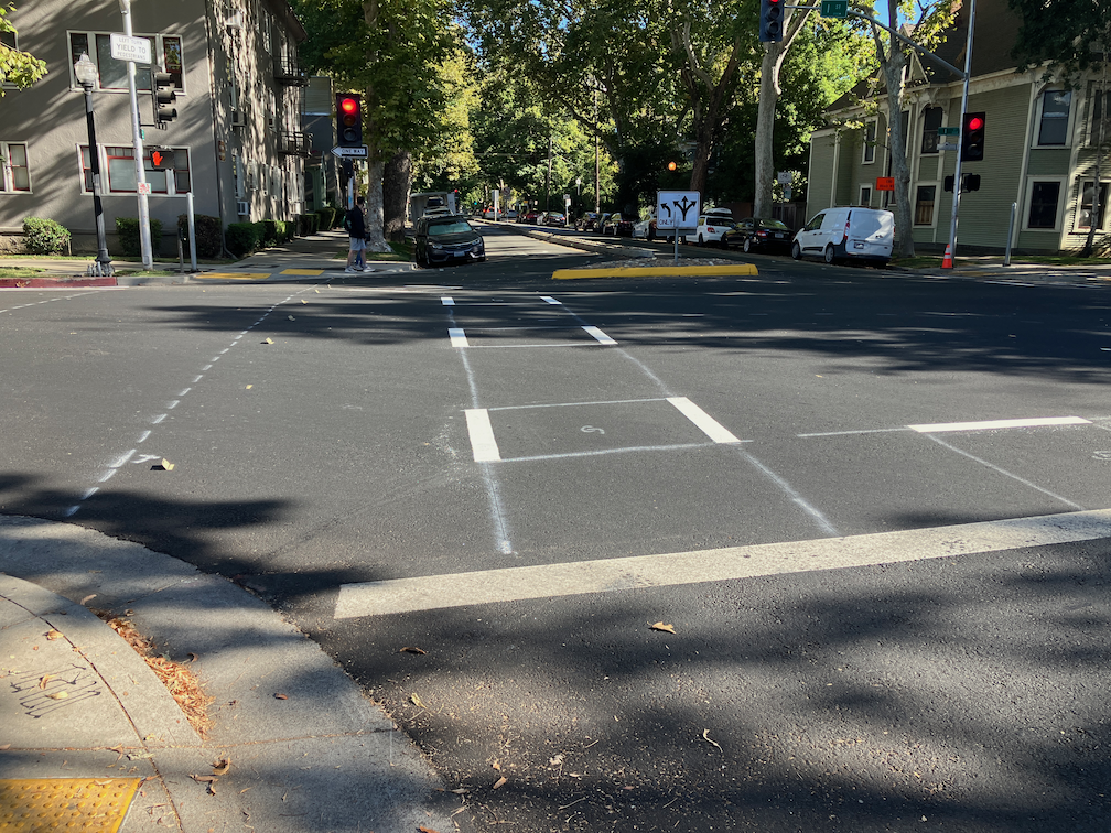
Another classic mistake by the City of Sacramento. Re-striping was just done on several blocks of N Street. Eastbound on N Street 22nd Street, this is what it looks like.

N St eastbound at 22nd St

Take a close look. Extend the dashed line forward, and you’ll see the taper, from a regular bike lane adjacent to a parking lane, to just a bike lane. Look even closer. See where the no parking sign is? A vehicle can park that close to the intersection, completely blocking the bike lane, and in fact blocking part of the general purpose lane. Yesterday, when I rode by, but neglected to take a photo, there was a large pedestrian-killer pickup truck parked right up to the no parking sign, and it was actually covering up three of the dash marks. Riding a bicycle in the bike lane and expecting it to continue? In Sacramento, that is not a reasonable expectation.

I would hope that the striping crew, whether city or contractor (not sure which this was) would notice the problem and stop painting until this was clarified. But it is not really the responsibility of the stripers. This design was signed off on by a ‘professional’ engineer employed by the city. This is the quality of people the city employs.

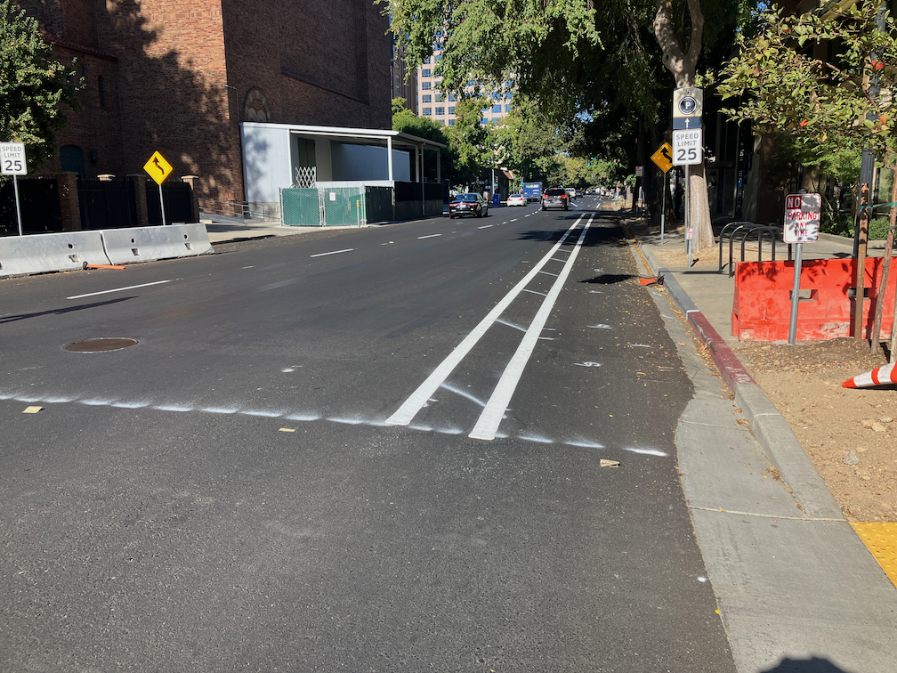
Westbound on N Street, it is not as bad since the no parking sign is further from the intersection. See below.

N St westbound at 22nd St

It is still a poor design, but nowhere near as dangerous.

As I’ve said before (traffic calming in the central city), these median islands, when placed in this way, as a widening of the center line only at intersections, are a hazard to bicyclists, though they do provide some safety for pedestrians. The best traffic calming measure, and the one that should be used by the city, is traffic diverters.

unacceptable accommodation

Sacramento City continues its practice of approving construction projects that do not consider the needs of walkers and bicyclists. Here is the latest I ran across, on Folsom Blvd between Santa Ynez Way and 39th St. The construction on the south side appears to be installing cable or fiber. At the west end, there is a sudden ‘sidewalk closed’ sign. There is no prior warning, there is no ramp or marked crosswalk for crossing Folsom to the north side (it requires crossing an offset intersection diagonally to go from one ramp to another, an exceptionally long distance), and there is no indication about how long the detour is.

At the other end, there is the same sort of signing without any prior warning or information provided.

At this location, 39th St, there is a marked crosswalk with traffic signal which could allow people to cross Folsom, but just to make sure the message that pedestrians are unwelcome here is clearly received, a construction truck was parked across the crosswalk. When I asked the construction crew to move the truck, they refused. I reported it to parking enforcement but am not sure of the outcome.

Of course there is a bicycle lane along this section of Folsom Blvd, which is also blocked by the construction. That may be justifiable, but you would think that forcing bicyclists to share the general purpose traffic lane would justify a reduction of the speed limit from 35 mph to 25 mph, but no, that that would inconvenience drivers and in the city, that is not to be considered.

This kind of bias against walkers and bicyclists should be unacceptable in the city. And it would be if the staff of Construction Services were not biased against walkers and bicyclists. Time to replace that staff with people who care about all modes of travel.

city failure on Capitol Mall bike lane

Sacramento has nearly completed a reconstructed bridge over I-5 between 3rd Street and Tower Bridge. This is part of a project to provide access from and to Old Sacramento, but that part is not complete yet. The pavement is fresh, with bright white lines and green carpet bike lanes. But, the bike lane design is a failure. The eastbound bike lane is OK. A little strange because it varies in width, but acceptable. The westbound bike lane, though, is a hazard to bicyclists.

Below is a photo of the first problem, a bike lane to the right of a place where a right turn is permitted. This is at the entrance to the Old Sacramento access.The straight-and-right arrow indicates that the city expects heavy right turning traffic at this location.

While this design is in compliance with the law, using a dashed line to indicate that traffic from the general purpose lane and the bike lane should safely merge, the use of green paint here is the wrong message. Though green paint has no legal meaning, the general meaning taken is that this is the place for bicycles. So an average bicyclist will stay in the bike lane, not realizing that the safe manesuver is to merge into the general purpose lane. The result is a right hook danger that has been created by the design.

IMG_0769
Stay to the right of right turning cars? NO!

There are a lot of ways to solve this issue, but this is the worst possible solution. Creating a separate signal phase for bicyclists and right turning traffic is one solution. Dropping the bike lane in favor of green-back sharrows in the general purpose lane is another.

However, this problem spot is minor in comparison to what happens just on the other side of the intersection. Here, the bike lane suddenly ends and becomes a right turn only lane. There is no signing for bicyclists or motor vehicle drivers, no pavement markings, no indication of what biyclists should do. I’m a vehicular bicyclist and would not be in this bike lane fragment to begin with, but for the average bicyclist, this green paint is a clear message, “this is where you belong.” Whoops. Sorry. Turns out we needed the road for a right turn lane, and just got rid of the bike lane. Hope you are still alive, but if not, well it wasn’t our fault. But the thing is, it is the city’s fault. This is a mis-design, and the city should be sued the first time someone is injured at this location. It is not as though this was an existing location where the city did the best if could to squeeze in bike facilities. This is a new construction where things should have been done right. They were not.

IMG_0771.JPG
Bike lane ends suddenly – good luck!

There are several good solutions for this location, and the NACTO Guide to Urban Bicycling has several, but even the standard MUTCD design is better than this. Though you can’t see the turn lane due to the parked FedEx van (it was there for more than 10 minutes, double-parked, and I couldn’t wait any longer for the photo), there are no bike markings in the right turn lane at all. There is no “bicyclists may use full lane” sign. Maybe bicyclists are meant to fly over this right turn lane and return to earth at the bridge. Or maybe they are meant to die.

As I always warn people in bicyclist education classes, don’t get sucked in by paint. Paint doesn’t keep you safe. And in this particular case, paint creates a danger for you that would not exist if not for the paint. Negligent design, for sure.

Trashing the bike lanes

Trash cans in bike lanes are epidemic, and are a public danger hazard to bicyclists. Placing a trash can, or anything else, in a bike lane is a violation of California Vehicle Code (CVC):

21211 (b) No person may place or park any bicycle, vehicle, or any other object upon any bikeway or bicycle path or trail, as specified in subdivision (a), which impedes or blocks the normal and reasonable movement of any bicyclist unless the placement or parking is necessary for safe operation or is otherwise in compliance with the law.

bike-lane-trash-cansSome people misunderstand where to place their trash cans, but most people know and don’t care – I’ve had extensive conversations with many such people – they don’t think that my right to the bike lane supersedes their right to put their trash can wherever they damned well please. The photo at right is on Tupelo Drive in Citrus Heights, trash cans placed directly in a marked bike lane. Notice that it would have been easy to place them in the parking “lane” instead, but the residents chose not to. This is not just a Citrus Heights problem, this photo could as well be any street anywhere in the region.

Read More »

More Sac county nonsense

MUTCD-2012_Figure9C-7The Bicycle Detector Pavement Marking (CA-MUTCD Figure 9C-7, shown at right) is placed to show a bicyclist where to stop so that they can trigger a traffic signal. When installed properly, they prevent the all-too-common scenario where bicyclists cannot trigger signals and must either cross against the red light when a safe gap is available, or wait until a motor vehicle arrives. They are also a clear signal to motorists that there is a reason why the bicyclist is positioned where they are. Of course “bicycles may use full lane” is true approaching any intersection where right turns are permitted, however, most motorists do not know or remember this law unless there is a sign there to remind them. The sharrow serves a similar purpose. However, these markings are often not installed in properly.

Mission southbound at Marconi, bike detector placement

Here is another fresh Sacramento County mistake, where the marking was not placed properly. On Mission Ave southbound, approaching Marconi Ave, there is a Bicycle Detector Pavement Marking in the bike lane, but not in the regular through/right turn lane. This marking is on new pavement placed in a complete streets project along Marconi from Mission westward to Fulton, and was installed within the last two years. If a bicyclist is to trigger the signal, they have to stay in the right hand edge bicycle lane, where they are at risk of getting right hooked. If they adopt a merge position between the two lanes, where they should be in order to make clear to motor vehicle drivers to either get in front or fall in behind, not beside, then the signal won’t trigger.

The solution is to place a marker in the regular lane, and adjust loop sensitivity if necessary, so that the bicyclist can choose which lane position to use.

Sac County just doesn’t get it

The photo below shows Garfield Ave southbound approaching Marconi Ave, in the Carmichael community of Sacramento County. This roadway was repaved within the last year, and this is the bicycle facility that was painted by the county. The bike lane veers to the right and then ends, running into the dedicated right hand turn lane, and another bike lane continues to the left of the right hand turn lane. These pavement marking clearly give priority to motor vehicles making a right hand turn, and ask bicyclists to yield to those vehicles, as second-class users of the roadways.

Garfield-sb-Marconi_bike-lane-shift

And this is what it could look like.Read More »

update on I

"bicycles must turn right" sign, I Street between 6th and 5th
“bicycles must turn right” sign, I Street between 6th and 5th

I wrote previously about the The I Street Mess. A small change has taken place here, with a new sign that says “Bicycles Must Turn Right” on the bike lane midway between 6th and 5th. Basically, this is a warning to bicyclists who missed the “Thru Bikes Merge Left” sign at the beginning of the block that they are truly screwed. By this point, bicyclist will have a very hard time merging across four lanes of high speed traffic to reach the left side bike lane that takes one to Old Sacramento or 3rd Street. At a minimum, the warnings need to occur earlier, in the block between 7th and 6th. Better yet would be slowing the traffic on I Street so that a bicyclist could actually maneuver through the traffic lanes. Best would be an alternate route for bicyclists who don’t wish to ride vehicularly, that avoids the I Street Mess completely.

14 foot lanes

There has been a discussion on the Association for Pedestrian and Bicyclist Professionals (APBP) listserv for the last two weeks on what to do with an outside lane of 14 feet (without on-street parking), particularly when there is a seam between the asphalt pavement and the gutter pan. Several people encouraged the use of narrow, substandard bike lanes in an effort to get something on the street, rather than using sharrows in the wide lane, or just leaving the lane unmarked. I believe we need to be very careful to not create “bike lanes at any cost,” and to carefully consider the actual roadway conditions before specifying anything that does not meet or exceed standards. The diagrams below are from the NACTO Urban Bikeway Design Guide. The first shows a high quality bike lane adjacent to a curb; the second one shows sharrows rather than a bike lane where there is not sufficient roadways width.

bike lane adjacent to curb (right side): NACTO Urban Bikeway Design Guide

shared lane markings adjacent to curb (left side); NACTO Urban Bikeway Design Guide

Read More »

Protected Intersections

When I posted on the North 12th Street Complete Street Project, I expressed concern about how the  cycle track to the north would transition to the bike lane to the south, and how bicyclists northbound would access the cycle track. On Wednesday I attended the project open house at City Hall. Preliminary designs presented by the contractor Echelon Transportation Group indicate one possible design for the intersection of 12th Street and C Street, a protected intersection. These conceptual design drawings are not yet available on the North 12th website, so I don’t have a drawing to share here. Comments from the open house and online will be used to revise the concepts, and they should then be available on the website for further review and comment.

The protected intersection is a design new to the United States, and so far not built anywhere in its entirety. The design is fairly common in bicycling friendly countries in Europe. The Protected Intersections for Bicyclists website provides a great video showing how the design works by providing a higher level of safety for bicyclists and pedestrians without much impact on motor vehicles. The design has not yet been included in the NACTO Urban Bikeway Design Guide, but I would guess it soon will be.

protected intersection

The diagram at right shows the general outline of a protected intersection. The intersection at 12th and C would look like the right half of the diagram on the west side, with the almond shaped corner medians, but would not look like the left half on the east side. Bicyclists heading south out of the cycle track would either continue south in the bike lane or use the protected intersection to turn east and then continue south on lower traffic streets. Bicyclists coming from the east would use the protected intersection to get to the west side and the cycle track.