The monthly meeting of the Sacramento Active Transportation Commission (SacATC) will be this Thursday, April 18, 2024, starting at 5:30 PM in the city council chambers. You can comment on these items, or on topics not on the agenda, ahead of time via eComment, or in person at the meeting. I encourage people to attend these commission meetings. There are usually very few members of the public in attendance, which means that your voice is important. Though eComments are valuable, in-person comments carry a lot more weight. The city’s planning staff is usually progressive and innovative, but Public Works in general is not, so it is important the citizens show up to push for progressive and innovative projects and policies. With some new appointments to the commission, and support of the public, the commission itself has been much more progressive than in past years.
The agenda includes three discussion items:
- Traffic Signal Safety Project
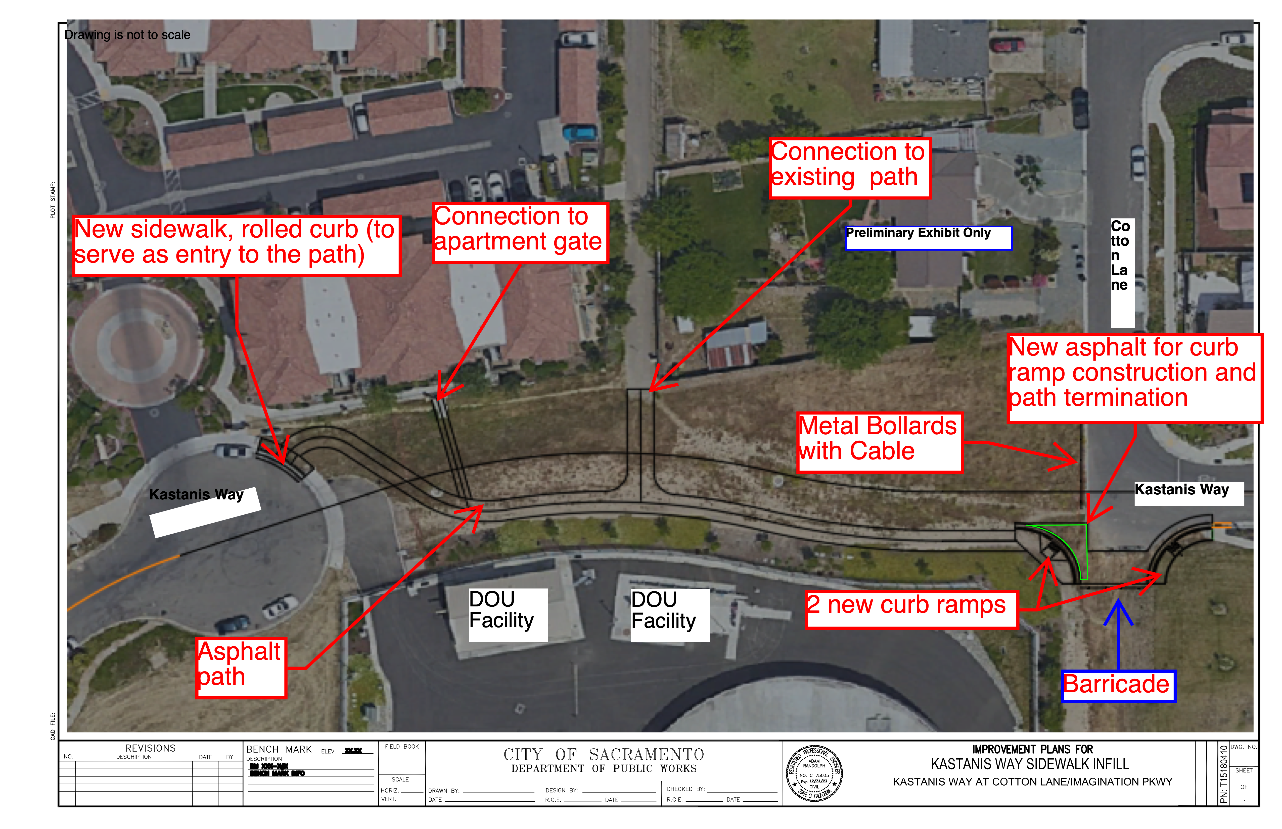
- Kastanis Way Shared Use Path
- Grand Avenue Sidewalk Infill
Kastanis Way Shared Use Path looks like a great project, connecting two dead-end streets for walkers and bicyclists, but not motor vehicles. These are the kinds of projects that should be implemented everywhere the opportunity exists.
Grand Avenue Sidewalk Infill also looks good, providing improvements to the crossing Grand Avenue by the Sacramento Northern multi-use path.

The Traffic Signal Safety project is questionable. There are nine locations:
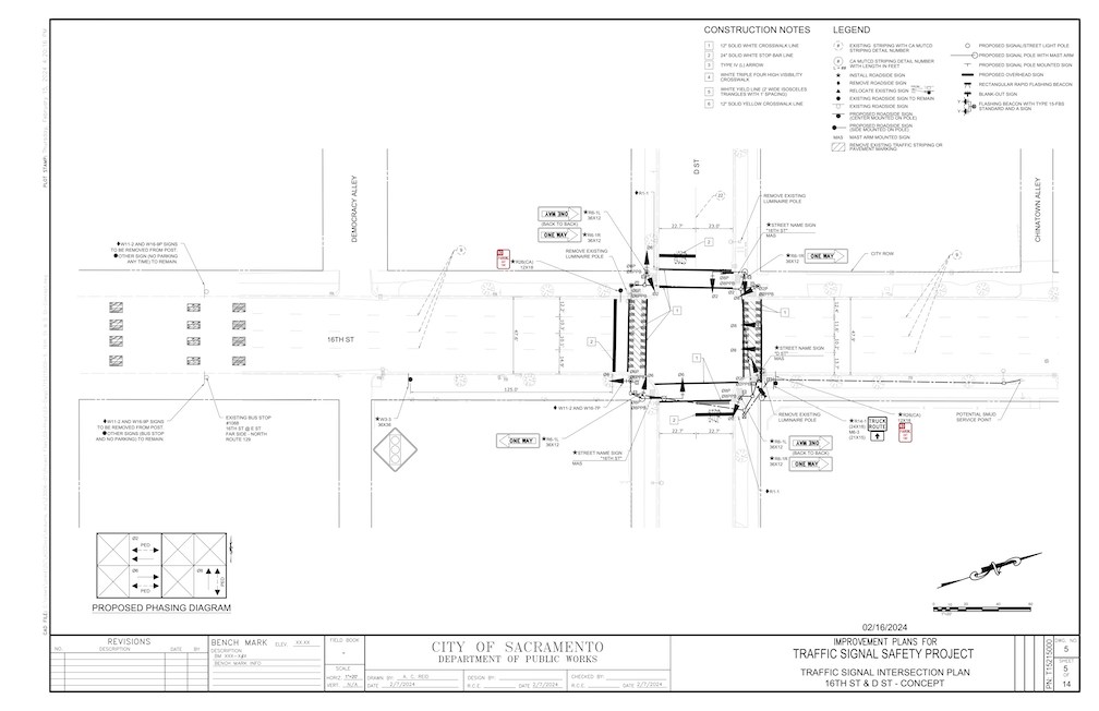
- 16th Street at D Street (Traffic Signal)
- Franklin Boulevard at 36th Avenue (Traffic Signal)
- Freeport Boulevard at Kitchner Road (Traffic Signal)
- Fruitridge Road at 60th Street (Pedestrian Signal)
- Rio Linda Boulevard at Harris Avenue (Rectangular Rapid Flashing Beacon)
- Stockton Boulevard at 11th Avenue (Pedestrian Signal)
- 24th Street at 25th Street (Pedestrian Signal)
- Munroe Street at Latham Drive (Traffic Signal)
- Rio Linda Boulevard at Roanoke Avenue (Rectangular Rapid Flashing Beacon)
I haven’t had a chance to look at each of these proposals, though I will note that the city traffic engineers love to install traffic signals. At $100K to $500K per intersection, these are major investments. Many of the new signals the city has installed, for example on 5th Street and S Street, are unneeded, and waste of money. They have also converted a number of pedestrian signals from auto-recall (the pedestrian signal comes on at every signal cycle) to beg buttons (the person walking or rolling must activate the sensor, or the pedestrians signal will never come on). The city has a number of unnecessary signals, 60 in the central city alone. Maybe a one-for-one program is called for, install a new signal, take out an existing signal.
I don’t trust city traffic engineers. They label projects as safety projects for walkers and bicyclist, when they are really motor vehicle infrastructure projects. So-called pedestrian and bicyclist safety projects are often motor vehicle enhancements in disguise.
I cross 16th Street at D Street several times a week on bicycle, and occasionally walking, most often to access the American River bike trail via Sacramento Northern path over the river. Yes, I have to wait for a gap in traffic on 16th Street, which sometimes takes a while. But rarely longer than I would have to wait for a traffic signal, given that the arterial street (16th Street) always has a long green and the cross street (D Street) has a short green. I think that funds would be better spent slowing motor vehicle traffic on 16th Street, or adding bike facilities to 16th Street, or reducing the travel lanes on 16th Street, which is a four-lane traffic sewer. Traffic signals do not calm traffic. They irritate drivers, and cause them to quickly accelerate out of the signal to make up for time lost at the signal. They may allow for safer pedestrian crossing, or at least would if red light running were not an epidemic in Sacramento. The fact is, many drivers do not stop for red lights, and certainly don’t stop for people walking in crosswalks. Measures other than traffic signals are necessary to solve the issue.
The proposal for an RRFB (Rectangular Rapid Flashing Beacon) for Rio Linda Blvd at Roanoke Avenue is inappropriate. The posted speed limit in this section of Rio Linda Blvd is 40 mph, meaning that actual speeds are more like 50 mph. This is too fast for an RRFB to have any effect on drivers. Even at slower speeds drivers often ignore RRFBs. If there is to be a safe crossing at Roanoke, there must be a HAWK signal, or a full traffic signal. Again, funds would be better expended slowing traffic on Rio Linda. At this time, there is no connection between Roanoke Avenue and the Sacramento Northern Bike Trail, so it isn’t clear why this location has been picked for a signal.

I will leave it to others to examine the other seven locations. Are signals needed? Are they the right kind of signal for the context, particularly the speed and volume of motor vehicle traffic? Are there projects that would improve safety for walkers and bicyclists more than expensive traffic signals? Are these the best locations, the ones that best serve routes of travel for walkers and bicyclists? I have doubts that these questions were considered.
Note: Readers Sean Rogers has suggested a better, and less expensive, solution for Monroe and Latham, in comments. The solution may be calming traffic, not just installing a signal.