I rode Freeport Blvd on Monday to refresh my memory, because I hadn’t been along the stretch in a few months. For readers who don’t regularly use Freeport Blvd, it may help you understand the city’s Freeport Blvd Transportation Plan. Yes, Freeport, as it is, has many problems. My concern is that the plan doesn’t solve most of them. The photos below include my thoughts about various places along Freeport Blvd. See the category Freeport Blvd for other posts.

This is Freeport Blvd north of 13th Ave, showing the conversion of what was a four lane traffic sewer to a two lane street. It includes a center turn lane, which is often not needed, in what is called a 3/2 configuration, two travel lanes and one center lane. It has regular Class 2 bike lanes. The sidewalks were repaired but not widened except at McClatchy High School. This is called a complete street.

Freeport Blvd adjacent to Land Park park. Sacramento City College is across the road. It shows the dirt/decomposed granite walking/running path within the park, which is great, but not usable during wet weather. There should be both a sidewalk and a natural surface walking/running path adjacent. A local advocate has suggested there be a separated two-way bikeway along this section, since there are no driveways and only two streets (two branches of 14th St) along this entire stretch of the park from 13th Ave to Sutterville Rd to the west.

Approaching Sutterville Rd to the east, the roadway design abandons all pretense of a traffic calmed complete streets and goes from two lanes to five travel lanes. Southbound, there is an extra lane without any added traffic, just to match the roadway to the south. Northbound, there is an extra lane which almost immediately merges back, and serves only the purpose of easing the high-speed free-right from Sutterville Rd to the east, and letting traffic merge after the intersection rather than before. Most traffic is heading east on Sutterville, not continuing north, so two lanes are not needed. The city is proposing a roundabout for this intersection, which makes sense, but they have designed a two-lane roundabout, which is significantly less safe than one-lane roundabouts.
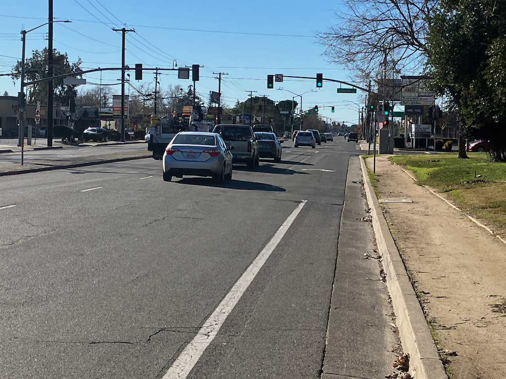
Freeport Blvd approaching Sutterville Rd to the west (right). The bike lane disappears in favor of a right turn lane. There is, at least at some times of day, significant right turn activity. The plan has a design where the bike lane crosses over the right hand turn lane with a dashed green pattern. Green paint has no legal meaning whatsoever, but it does serve somewhat to alert drivers to bicycles. In this heavy right turn situation, something more innovative than green paint is needed. Perhaps a bike signal face that holds motor vehicle traffic while bicyclists are moving.

Freeport Blvd southbound approaching the new Raley’s shopping center. As part of the development agreement, the project installed a sidewalk buffer (often called planting strip) and a wider sidewalk. This is a good design, as it provides shade for walkers (when the trees mature) and a buffer from the noise, exhaust, and violence of motor vehicle traffic. But it is NOT the design proposed in the plan, which does not use sidewalk buffers and trees except at a very few locations. The buffered bike lane is better than a regular bike lane, but would be better with vertical delineators (soft hit posts) or physical protection.
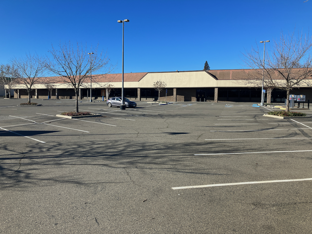
This is the abandoned store and parking lot, where Raley’s used to be. The new store is nice, but this abandoned location is a blight on the neighborhood. If the county continued to change the same property tax as when the store was open, it would be much more likely to either be filled with another business, or replaced with different land use, perhaps housing and small businesses. But with the owner paying little it property taxes as is, it will probably remain abandoned for years.
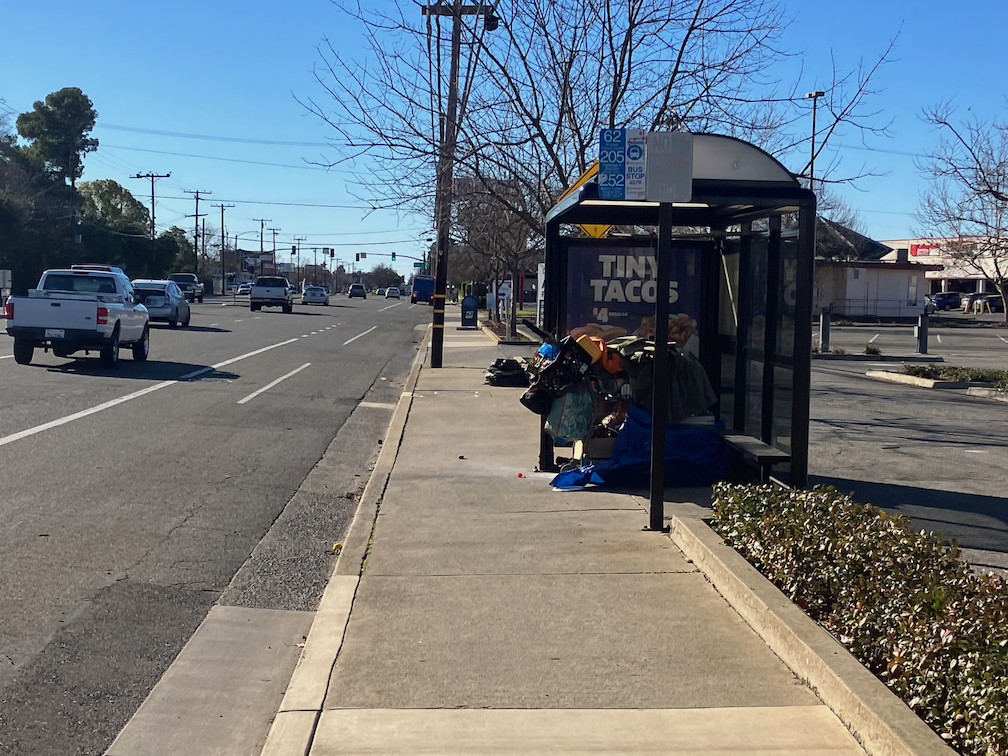
Freeport Blvd typical roadway. There is an unprotected bike lane, with a parking lane to the right of it (not right here, as there is a very faded no parking sign for the bus stop), and wide traffic lanes. The sidewalk is good, and the bus shelter is good, not blocking the sidewalk. The only issue is the homeless possessions using the bus stop. Looking down the street, this area of parking is unused (the one vehicle is temporarily stopped, not parked). Where there is ample off-street parking, the on-street parking is seldom used. The plan does remove a lot of unused parking. More about on-street and off-street parking in another post.

A typical setting on Freeport Blvd. A strip mall set back from the street with a narrow area of parking fronting the street. Unused on-street parking. The setting works, sort of, but what an unpleasant place to be, whether walking, bicycling, or driving. Nothing to grab your interest, or make you slow down, or shade you (nary a tree in sight). On the other hand, a lot of small businesses are the strength of this area, providing variety, and significantly higher sales tax and property tax income than large buildings with a single business.

Freeport Blvd south of Oregon Drive, with narrow sidewalk further narrowed by utility poles, and a blank fence. The blank fence is a response to the unpleasantness of the roadway; the developer wanted to isolate the homes from the noise and violence of the street. Understandable. But it leaves a long stretch of street with nothing to look at, and an unpleasant experience for someone walking. The world is only fence and traffic. The plan does not change this in any way, including not widening the sidewalk. It is unknown if the utility poles will be moved or removed.

Freeport Blvd at the intersection with Fruitridge Rd. It this a place where anyone wants to be? This is the largest intersection in the plan area, and is also the highest crash intersection. Southbound, the roadway widens from two lanes to five lanes, with two dedicated left turn lanes (unneeded, according to the plan) and a dedicated right turn lane. With the two northbound lanes, this is seven lanes of traffic to cross, with no pedestrian refuge median, 86 feet total. With the default 7 second white hand and standard walk rate of 4 feet/second, this is 29 seconds to cross. Not only is this too long for the walker, but it is too long for traffic to wait. A narrower roadway is good for the walker, and good for the driver because the signal cycle can be shorter. But the plan makes no changes to the lane configuration of this intersection. None.

Fruitridge Rd westbound approaching Freeport Blvd. This is the single worst aspect of this intersection, the free right slip lane which allows high speed turns from Fruitridge to Freeport. You might think that the signal stops right turning traffic, but it does not, it is on the same cycle as the though traffic. These high speed slip lanes are pedestrian killers. A driver is looking only to their left, for conflicting motor vehicles, not to their right for people walking. Just while standing here, I saw five drivers take this turn at over 35 mph. Slip lanes are never appropriate in an urban environment, and should be removed. But the plan does not change this at all.

Freeport Blvd south of 35th Ave. There are significant sidewalk gaps. There are commercial buildings on the west side (right), but only about half the businesses are open. As you can see, this section of Freeport has a completely different feel than north of Fruitridge, and I think should be considered separately. In fact, given the traffic levels and acceptable bike lane, I’m not sure anything needs to be changed here at all. This is not a place people would walk.

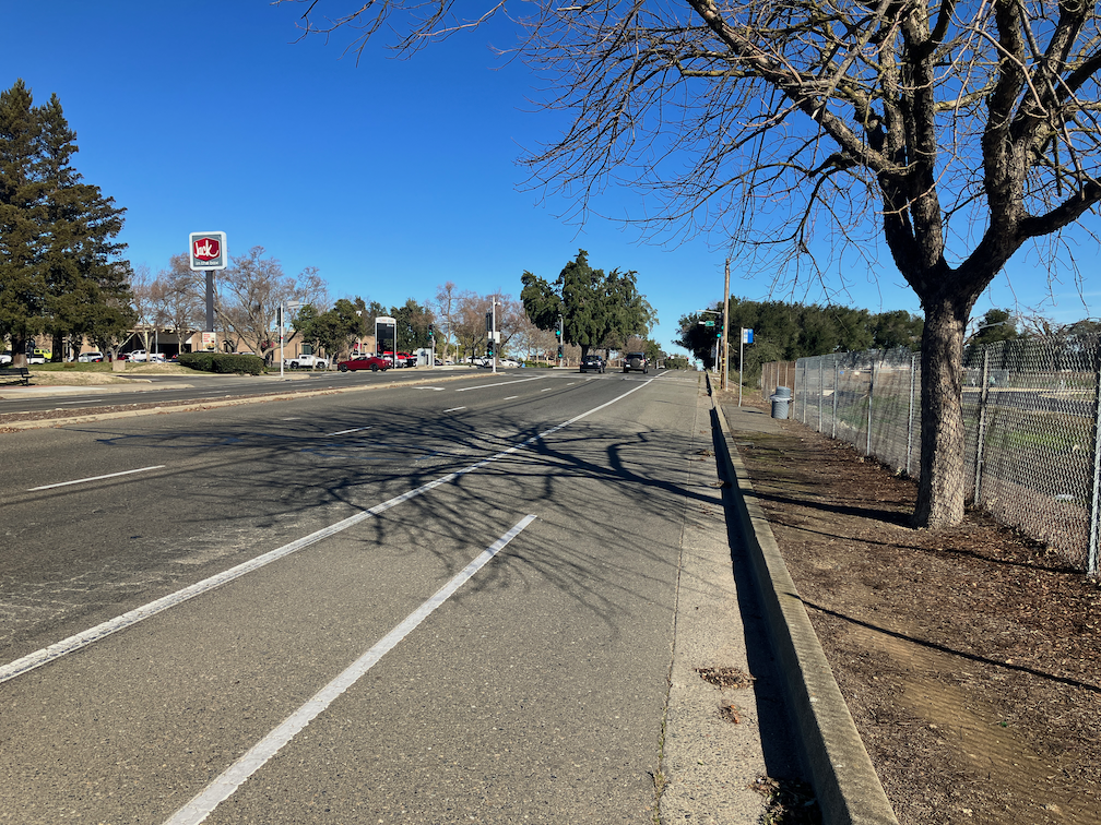
Freeport Blvd northbound, just north of Blair Ave. Looks good, but this is just the part close to the airport entrance. This does not continue very far northward. Note the 40 mph speed limit, which means the roadway is designed to be ‘safe’ at 50 mph. Of course it is not safe at 50, or 40. It should be both designed and posted as 35 mph.
And this is what it looks like to the north. A parking lane where no parking would ever be needed, alongside the airport, just because the city over-built the roadway width. No sidewalk, just a use path. A chain link fence, that most hostile of fencing designs. Yuck. This is also a section where a local advocate has suggested a separated two-way bikeway, since there is only one driveway in the entire section of the airport between Blair Ave and Fruitridge Rd, a half mile of uninterrupted roadway northbound.

Freeport Blvd northbound, just south of 35th Ave. Just to emphasize how hostile this area is to walkers, a bus stop with no sidewalk connections at all. The crosswalk to the north, at 35th Ave, is not accessible to anyone with a mobility device or even mobility impairment. To the south, it is just dirt. I don’t know how many riders use this stop, but I can guarantee that every one of them is unhappy about the stop. However, I’m not at all sure that building a sidewalk along this stretch of the airport, as the plan proposes, is useful or cost effective. How many people would walk? It is two miles along the east side of Freeport to anything a walker would want to access. Better to spend the money on places where people do or will walk.

Freeport Blvd at Claudia Dr. Another location where some improvements have been made, with better sidewalks and detectable warning strips (the bumps) for ADA. But to what end? It still feels car dominated to me, with unnecessary parking, a regular bike lane, multiple overly wide driveways. This is what the city intends that most of Freeport Blvd will look like after the improvements.

Freeport Blvd. Another strip mall. Multiple very wide driveways. You can see the slope of the driveway aprons here, essentially not navigable by mobility devices. The two solutions here are a driveway apron in the sidewalk buffer, so that the sidewalk is level (the best solution), or having the sidewalk ramp down to cross a flat driveway segment (an acceptable but not optimal solution). But there is no sidewalk buffer here, and the city does not intend that there be. Either they will leave these driveways in unacceptable condition, or will do the ramp down. The plan does not get into such details, but the one diagram that shows a driveway (Proposed Prototypical Concept on page 25) shows the sloped driveway apron, neither solution.

Yet another strip mall. No sidewalk, a poor quality bus stop, two-directional parking lot traffic in a narrow undefined space (I observed several driver conflicts while taking the photo). At least the on-street parking has some utilization.

Freeport Blvd at Meer Way. This is another location where the city has improved pedestrian crossing. The offset sidewalk in the median is intended to face walkers toward oncoming traffic so that they notice drivers running the red light, which is kind of a sad statement on safety from drivers. This is not a bad crossing, and probably safer than what was there before, but look at all those signal heads, just to make crossing the street safer. This is probably a $100,000 intersection, and it is only one of many along Freeport. If the city slowed traffic to 25 mph, both designed and posted), these fancy and expensive crossings might not be needed.
There are a few more posts to come, diving into specific issues.

[…] now, the Freeport – Fruitridge intersection. I’ve already made comments on this in the photo essay, but to repeat and look more closely… This is what it looks like today. There are […]
LikeLike
[…] Freeport roundabout(s), Freeport trees and sidewalk buffers, Where are the trees on Freeport?, Freeport Blvd photo essay, Freeport & Fruitridge intersection, make Freeport 3 segments, wide lanes on Freeport, […]
LikeLike
[…] Freeport Blvd photo essay […]
LikeLike