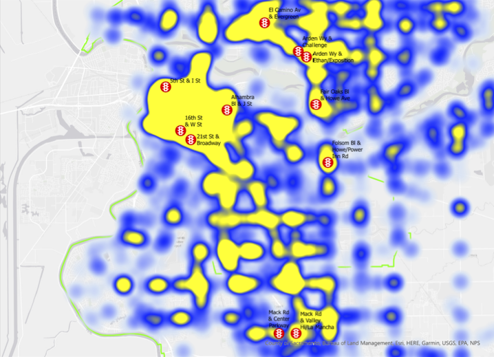
A follow on to red-light-running bullies. I’ve created a map that shows the eleven right light camera (automated enforcement) locations under the City of Sacramento’s Red Light Running Program. The city has 907 signalized intersections. These locations are (listed alphabetically by the intersection entry in the Traffic Signals GIS layer):
- 16th Street & W Street X
- 21st Street & Broadway X
- 5th Street & I Street X
- Alhambra Boulevard & J Street
- Arden Way & Challenge Way X
- Arden & Exposition Boulevard & Ethan Way X
- El Camino Avenue & Evergreen Street X
- Fair Oaks Boulevard & Howe Avenue X
- Folsom Boulevard & Howe Avenue/Power Inn Road X
- Mack Road & Center Parkway X
- Mack Road & La Mancha Way/Valley Hi Drive X
The map (pdf) shows each location, with the red signal icon, and a heat map of the crash severity for crashes occurring at intersections. Yellow means high collision severity, with severity being a weighting of the individual types [1 – Fatal; 2 – Injury (Severe); 3 – Injury (Other Visible); 4 – Injury (Complaint of Pain)]. But it does show the pattern, and you can clearly see the intersections along arterial roadways, where most crashes occur. The crashes are not necessarily red light running crashes. There is a PCF Violation category (VIOLCAT) 12 – Traffic Signals and Signs, and another Intersection (INTERSECT_), but that would not distinguish red light running from stop sign running. It might take looking at individual incident reports, but that is beyond my capacity.
There are certainly high crash severity locations in the city that are beyond the map coverage area, and there are plenty of locations without cameras.
It would be interesting to know if these red light camera locations have a lower rate of red light running crashes that comparable intersections without cameras, but that will require quite a bit more thinking an analysis.
You can read about Red Light Running on the Insurance Institute for Highway Safety, which is supportive of red light cameras. If you search on Google, you can find hundreds of articles and some actual research on their safety benefits, both pro and con. It is clear that drivers and libertarians don’t like them. But a lot of crashes at intersections are motor vehicle on motor vehicle, not just walkers and bicyclists. There are two possible benefits to red light cameras: 1) at that specific intersection, as drivers learn not to run red lights there; and 2) across many intersections or areas, as these red light running bullies are ticketed.

[…] I wrote about a crash at P Street and 15th Street. I’ve written multiple times about red light cameras, pandemic of red light running, red-light-running bullies, and SacCity red light cameras and crashes. […]
LikeLike
[…] written about this before: how do we get more red light cameras?, red light running consequences, SacCity red light cameras and crashes, Sac Vision Zero intersections & red light cameras, red-light-running bullies, and pandemic of […]
LikeLike
[…] of red light enforcement; how do we get more red light cameras?; red light running consequences; SacCity red light cameras and crashes; Sac Vision Zero intersections & red light cameras; red light cameras; pandemic of red […]
LikeLike