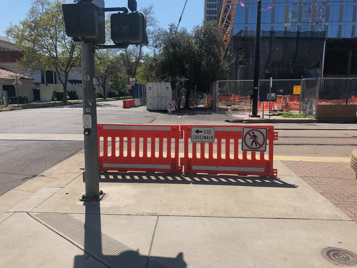
The first City of Sacramento Transportation & Climate Workshop was held last night as part of the regular city council meeting. The first news, which was not at all clear before, is that this is the first of several workshops, which will develop the plan further. The next workshop has not been scheduled, but may be in March.
screen capture from city presentation
Some highlights:
No one spoke against the seven big idea projects.
People liked the enhanced bus lane on Stockton for SacRT route 51, but it didn’t receive much notice in the discussion.
Nailah Pope-Harden of Climate Plan and a local activist, said bold is the minimum, and said all projects should be about reconnecting communities. Many other speakers referred back to Nailah’s challenge.
The opening slide of the city presentation showed SacRT bus route 30 on J Street, pulled out of traffic and blocking the bike lane. Irony probably unintentional, but it does illustrate one of the ways in which the city does not support transit or bicycling. The bus should not be pulling out of traffic, but stopping at a bus boarding island with the separated bikeway running behind it.
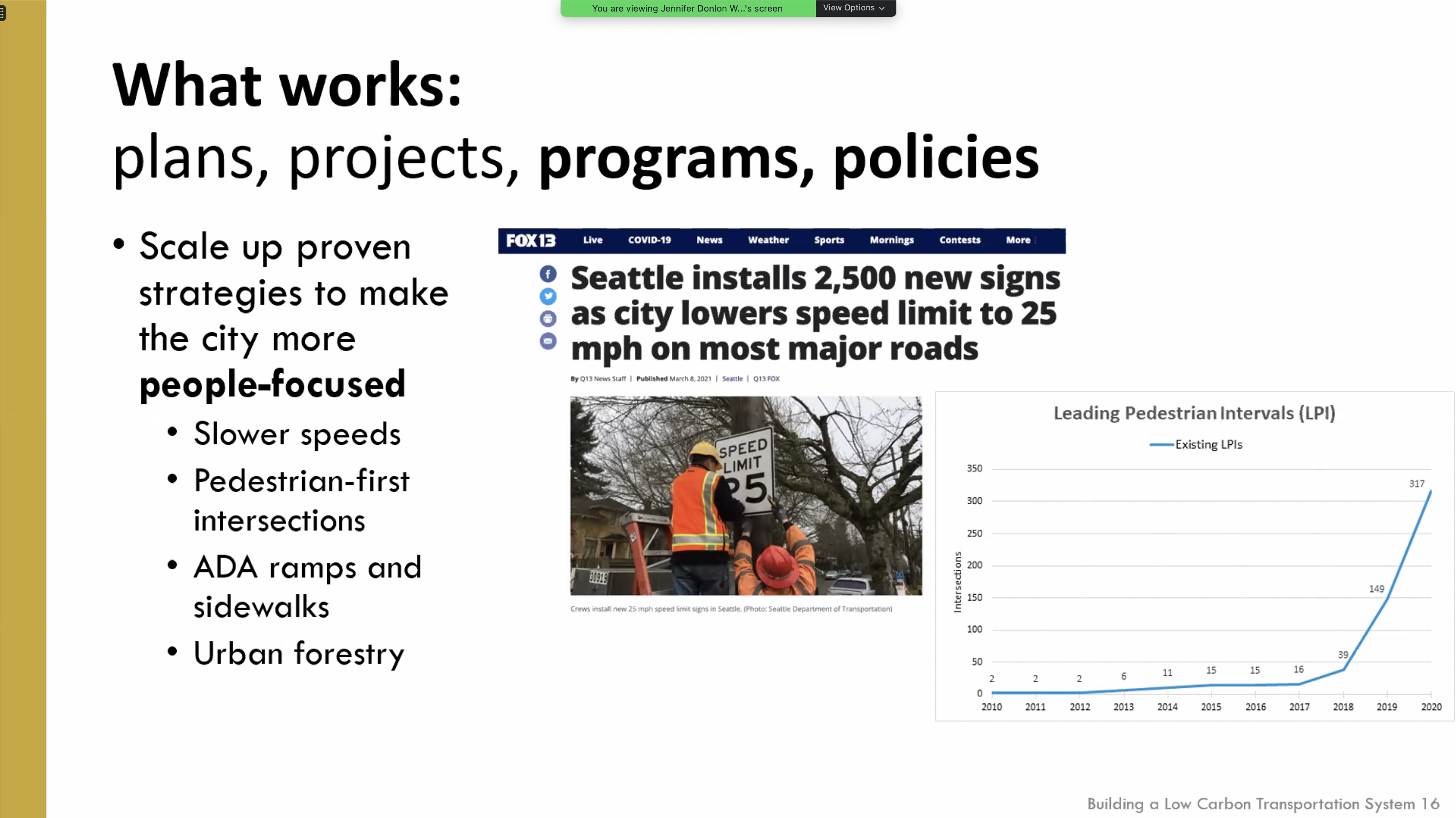
Sam Zimbabwe of Seattle DOT presented on the ways in which the city has shifted mode share to transit with projects and priorities. One of his slides showed the huge increase in the number of intersections at which they have programmed leading pedestrian intervals (LPIs) to enhance pedestrian safety.
Jeff Tumlin of San Francisco MTA said they have realized that waiting for a few big projects is an ineffective approach, and are now doing many small projects, often with temporary measures that can be improved when made permanent. He said that sales taxes don’t have to be regressive, if the benefits are directed to the right places and projects, and that well-designed congestion pricing is not regressive. He also suggested that city staff should be challenged to a higher level of productivity and innovation, and let go if they choose not to meet that. He also spoke about SFMTA’s approach, with partners, of working on transportation and housing as a unified goal, not siloed.
Darrell Steinberg mentioned several times the idea of the city doing a transportation ballot measure so that it could set its own priorities for investment rather than compromising with the county (SacTA) over projects which don’t meet the needs of the city.
City staff said transportation is now 56% of carbon emissions in the city, which is higher than numbers reported before.
Ryan Moore poo-poo’d the idea of lowering speed limits, saying the MUTCD prevents that, without mentioning the state law which allows reductions in specific circumstances. Others pushed back on this.
Rick Jennings spoke enthusiastically about getting more kids on bikes and his own experience of bicycling with kids.
Jeff Harris spoke about EVs, despite the setup of the workshop being about other transportation ideas, not EVs.
Mai Vang pointed out that the ideas are too District 4 (central city) focused, believes that there should be more focus on low-income and outlying areas. She said we need better access to light rail stations, not just bicycling access to downtown.
Civic Thread spoke (all their employees!) about the need for a city-wide Safe Routes to School program to address the recent parent death at school dismissal at Hearst Elementary, as well as safety needs at every school. They also highlighted equity and community access.
Henry Li and Jeff Harris pointed to micro-transit (SmaRT Ride) as being a great success, but SacRT has still not provided information to the community to judge that.
Henry Li spoke mostly about funding, and did not address the Stockton/Route 51 project. He again highlighted light rail to the airport, despite the transit advocacy community’s request that all light rail extensions including ARC/Citrus Heights/Roseville considered before selecting the next project.
The message from the invited speakers and the community was clear: we need to make big changes in a hurry, and city funding and commitment will be necessary for that to happen. How will the city respond?
What are your highlights from the workshop?
screen capture of Seattle DOT slide on speed limits and LPIs
The City of Sacramento is going to consider some big, transformative projects Tuesday evening. That’s great. But let’s not forget all the small things they could be doing, but aren’t:
Mark crosswalks at every intersection. Except in purely residential neighborhoods, these should be zebra design.
Daylight intersections by removing parking from within 15 feet of every crosswalk, at least on the near side (far side is a lesser safety benefit)
Re-program traffic signals to create leading pedestrian intervals, everywhere.
Remove or properly label every pedestrian push button. Don’t make walkers play the guessing game. Except at very low use intersections, pedestrian signals should be on auto-recall.
Remove pedestrian prohibitions which serve traffic flow rather than safety of walkers. This is the majority of them.
Install traffic diverters (modal filters) on about one-quarter of all streets, at no less than 1/8 mile intervals. This discourages through-traffic on most streets, and discourages longer driving trips, while being permeable to bicyclists and walkers.
Charge for all street parking, everywhere, even in residential neighborhoods.
Reduce speed limits to 20 mph, citywide and all at once, on every street that is not an arterial or collector street.
Ensure that every construction project that reconstructs sidewalks also installs curb extensions (bulb-outs) where there is a parking lane present. This is not uniformly happening.
Create interim curb extensions with paint and flexible posts.
Take on responsibility for maintaining sidewalks, since they are an integral part of the transportation network.
Buy every employee of Public Works and Community Development a copy of Walkable City Rules (Jeff Speck), and hold sessions to develop a new city mission that prioritizes walkers (and bicyclists and transit riders) over private vehicles.
The City of Sacramento Active Transportation Commission (SacATC) was established in 2018 as a replacement for the city/county Bicycle Advisory Committee (BAC). This was good, as the county’s unwillingness to consider innovative solutions, even when they were in the city, meant that very little ever happened there. There was a lot of hope in the bicycling and walking advocacy community that SacATC would turn a new page and accelerate necessary changes in the city. Unfortunately, that has not been the case. The commission has been reactive, not proactive. A number of people have resigned from the commission when they discovered that not much of importance was happening there.
Nothing here is meant to demean the contributions of city staff to seeking grant funding for critical projects. The city is paying much more attention to active transportation than it used to, but I and many other advocates believe that it is still paying too little attention, and certainly too little funding.
So, I believe it is time for a reset.
SacATC is advisory to the city council. It should therefore be communicating with council on a fairly regular basis. That does not mean that it does not collaborate with staff, but it does not take direction from them.
The primary job of the commission should be to review and to create policy. Reviewing projects is a secondary focus. That means at least half of every meeting should be spent talking about policy, not about projects.
SacATC should be setting its own agenda, not letting staff set it. If staff wants to bring something to the commission, they would contact the commission chair to request that it be on the agenda. The chair should solicit agenda ideas from commissioners at the end of each meeting, and again, in advance of the next meeting to meet whatever deadline the city sets for its agenda posting.
The purview of SacATC should be all city activities, when they may affect active transportation, not just Public Works. This would include, for example, construction traffic control plan permitting, city utility work in the streets, waste collection (trash cans in bike lanes), repaving plans, law enforcement, and parking enforcement.
SacATC supported sidewalks where they are part of complete streets projects, but has not addressed sidewalk infill, closing gaps in this critical transportation infrastructure. I believe this should be a major focus of the commission this year, developing policy to recommend to the council that makes consistent and rapid progress towards a continuous sidewalk network, properly designed ADA ramps at every corner, and frequent safe crossings.
The City of Sacramento has 11 red light camera locations: Red Light Running Program. Of these, some are at high-injury intersections, but most are not. These locations are cross-referenced with high injury intersections shown in the post Sac Vision Zero new intersections map.
Location
Top all
Top ped
Top bike
Mack Rd & La Mancha Way/Valley Hi Dr
no
no
no
El Camino Ave & Evergreen St
no
no
no
Howe Ave & Fair Oaks Blvd
no
no
no
Mack Rd & Center Parkway
no
no
no
Exposition Blvd & Ethan Way
no
no
no
Broadway & 21st St
no
no
no
Folsom Blvd & Howe Ave/Power Inn Rd
no
no
no
Arden Way & Challenge Way
no
no
no
5th St & I St
no
no
no
16th St & W St
no
no
no
Alhambra Blvd & J St
no
no
no
My first thought is that the city was putting these cameras in the wrong location. But then I thought, what if the presence of red light cameras is making these locations safer and therefore dropping them out of the highest injury intersection list. I don’t have the information to answer that question, which would take analysis of crashes at the intersections, and before/after data.
What I do know is that many more red light cameras are needed to counteract the pandemic of red light running: pandemic of red light running. I spend time around the edges of Fremont Park, close to where I live, which includes the intersection of arterial streets P, Q, 15th, and 16th, and one of the things I do is watch traffic in the intersections. It has now become rare for a signal cycle for 16th St northbound at P St to not see an incidence of red light running. The other intersections are not quite as bad, but the pattern is there. And this is happening everywhere in Sacramento that I go; these are not likely to even be the worst intersections.
I believe that most of the red light running is by egregious violators, people who routinely and continuously violate traffic law for their own convenience or thrill seeking. This is true of most traffic violations, but red light running is the one most likely to result in fatality and serious injury, for people in all modes of travel. So having a more widespread set of red light cameras would serve to catch these red light violators. Of course the follow-up is necessary, to revoke the licenses and confiscate the vehicles of these repeat offenders. The longer the city looks the other way on this issue, the more people will come to see it as normal behavior, and the less safe our streets will be.
The standard response by cars-first entitled drivers is that tickets are just a money-making scheme by the government. The purpose of red light cameras is to make streets safer, and if that results in some income, so be it. I’m more than happy to have these sociopathic drivers hit in the pocketbook, and the money can be used to make our streets safer, such as by installing more red light cameras. Red light tickets, with photos, are part of the documentation needed to revoke licenses and confiscate vehicles.
I have finally gotten to reviewing the Stockton Blvd Corridor Plan, following my post noticing the draft plan: Stockton Blvd draft available.
Overall, the plan is great, and when someday implemented, will result in a much safer and livable Stockton Blvd. The plan addresses major concerns raised by the community, including safer and more frequent crossings, better lighting, more trees, more effective transit service, and others. However…
The plan is still too oriented to the throughput of motor vehicle traffic. Better, but not as good as it could be. Maintaining the five lane configuration for significant parts of the corridor is unnecessary.
The plan does not even mention speed limits. When any street is reconfigured/reallocated, it removes any obligation to the unsafe and outmoded 85% rule, so the city should have considered speed limit changes for the corridor.
The plan recommends two-way cycle tracks in some locations. These are great for traveling along, but the problem comes in transitioning into and out of them at the beginning and end. Unless very clear guidance and priority is provided, these transitions can be very unsafe, particularly for less experienced bicyclists. In most cases, a bicycle signal head with exclusive bicyclist phase is required at beginning and end.
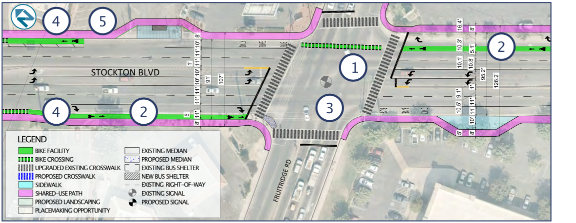
The plan acknowledges the challenging intersection of Stockton Blvd/34th Street/R Street as a “unique challenge” (page 13), but doesn’t even suggest solutions. I believe that the only way to make this intersection safe is to either restrict R Street or 34th Street, or to construct a flyover for light rail, similar to that for 19th Street, Watt Ave, and Sunrise Blvd. Yes, the expense of any of these might be beyond the scope of this plan, but eliminating this issue from the plan makes it difficult to compare the relative cost and benefit of other solutions.
On page 36, a diagram shows a bike lane eastbound on T Street to the right of a dedicated right hand turn lane. Bike lanes should never be to the right of dedicated turn lanes unless there is a bicycle signal head to create an exclusive bicyclist phase, which the plan does not propose. This must be fixed.
Shared bus and bike lanes will be a new concept for the city, and region. I support the implementation of these, and have used them in several other cities where transit frequency is not high. But they should be considered a pilot. If they don’t work out for bicyclists, and bus drivers, in this region, how do we fix it?
The flared intersection at Stockton Blvd and Fruitridge Road is preserved in the plan, but this is completely inappropriate. Flared intersections are always more dangerous for people crossing the street. The roadway width at the intersection, shown on page 41, is 90 feet. Crossings of this length cannot be safe, no matter what the length of the pedestrian cycle, without a pedestrian refuge median (with push buttons unless the pedestrian crossing is already on auto-recall). Double left hand turn lanes are dangerous for drivers and everyone else, as driver attention is focused on the vehicle beside, and not the roadway ahead, so these should be reduced to single left turn lanes. The right hand turns lanes should probably be eliminated, unless a traffic study shows conclusively that traffic would not clear during a signal cycle without them. The upshot is that this intersection should be completely reconfigured, not just tinkered with.
The plan does not indicate which intersection signals and signalized pedestrian crossings will be on auto-recall, or not. There is probably no justification for pedestrians activation buttons at any location on the corridor (pedestrian crossings should have auto-detection), but if there is, these should be called out clearly in the plan.
The plan shows most intersections as having skipped (dotted) green bike lanes striped through the intersection, but a few do not. They should be used everywhere. For the protected legs of partially protected intersections, the striping should be continuous rather than skipped (dotted). MUTCD frowns on this, but it has been installed many places with positive safety outcomes.
Added item: No right turn on red prohibitions should never be used without leading pedestrian intervals (LPI). Otherwise, drivers turning will immediately come into conflict with walkers in the crosswalk. I don’t think this is being proposed in this plan, but just want to make sure.
The City of Sacramento Active Transportation Commission will consider the plan this evening (2021-03-18). I apologize for not posting this in time for you to consider my suggestions, and relay them to the commission, if you agree.
Stockton Blvd & Fruitridge Road intersection
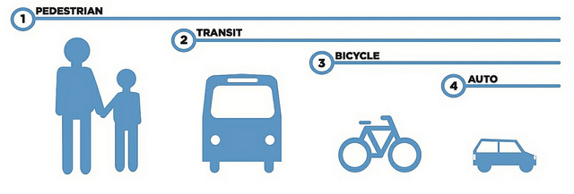
Added info: There was a discussion about the prioritization of different travel modes during the SacATC meeting this evening. It reminded me of one of my favorite graphics about transportation modes, from Chicago Department of Transportation. I think this is the right answer for Stockton Blvd, and for nearly every other roadway.
legend for intersections on maps belowSacramento top collision intersections, north sectionSacramento top collision intersections, south section
The intersection data is in the table below.
What’s next? I’ll take a closer look at some of these intersections. For people who follow traffic engineering, it will probably be immediately obvious why these intersections are dangerous. A detailed analysis requires looking at each collision record individually, which I don’t have time to do. The city did make use of incident reports, which contain more information than the data in SWITRS, in developing the Vision Zero Plan.
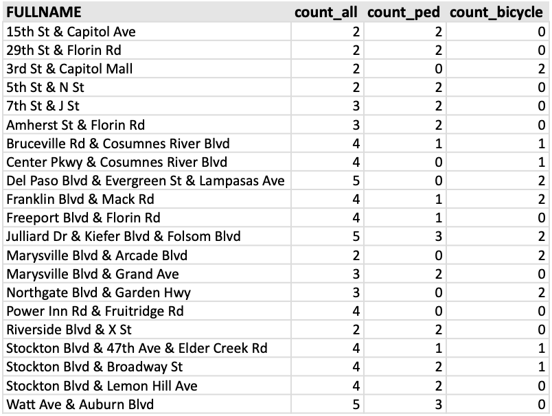
As promised, a follow-on to my post on the top bicycle collision intersections in Sacramento (Sac Vision Zero Top 5 Corridors and top intersections), here is the same sort of analysis for pedestrian collisions. I used a somewhat different data set, this time only killed and severe injury crashes (KSI), for the years 2009-2017. This mirrors the data the city used in the Vision Zero Top 5 Corridors document, and so is not directly comparable to the different criteria I used on the bicycle post.
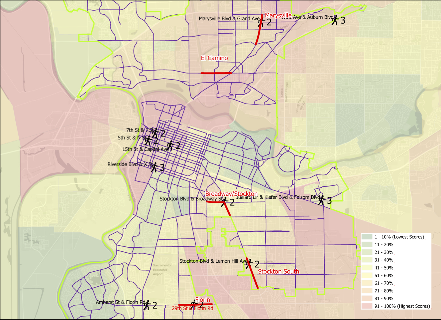
Pedestrian (walker) collisions are more dispersed that bicycle collisions, fewer occurring at intersections and more in between. Of the 408 collisions, 70 were at intersections, 17%, compared to 69% for bicycle collisions. Of these 408 collisions, twelve intersections stood out: Amherst St & Florin Rd, Marysville Blvd & Grand Ave, and Watt Ave & Auburn Blvd, each with three; and 15th St & Capitol Mall, 29th St & Florin Rd, 5th St & N St, 7th St & J St, Stockton Blvd & Broadway, Stockton Blvd & Lemon Hill Ave, Riverside Dr & X St, and Julliard Dr & Kiefer Blvd & Folsom Blvd, each with two. Of these 12 intersections, 4 are on Top Five corridors: Marysville Blvd & Grand Ave on the Marysville corridor, Stockton Blvd & Broadway on the Stockton-Broadway corridor, Stockton Blvd & Lemon Hill Ave on the South Stockton corridor, and 29th St & Florin Rd on the Florin corridor.
The map belows shows the city corridors and the twelve intersections, with the number of collisions and intersection name labeled. There is also a pdf available.
Sacramento pedestrian collision top intersections, with Vision Zero corridors
There is a better alignment between the five designated corridors and pedestrian collision intersections than was true for bicycle collisions.
I will point out that the Julliard Dr & Kiefer Blvd & Folsom Blvd intersection is the site of three pedestrian collisions and four bicycle collisions, which is higher than any other intersection in the city. It should really be a focus for the city.
Addition 2021-03-02: Someone asked how the pedestrian collision locations relate to disadvantaged communities. Below, a map with CalEnviroScreen 3 2018-06 (CES) layer, with red end being higher pollution, green being lower, and weighted with income. CES is not the only measure of disadvantage, but it is one commonly used.
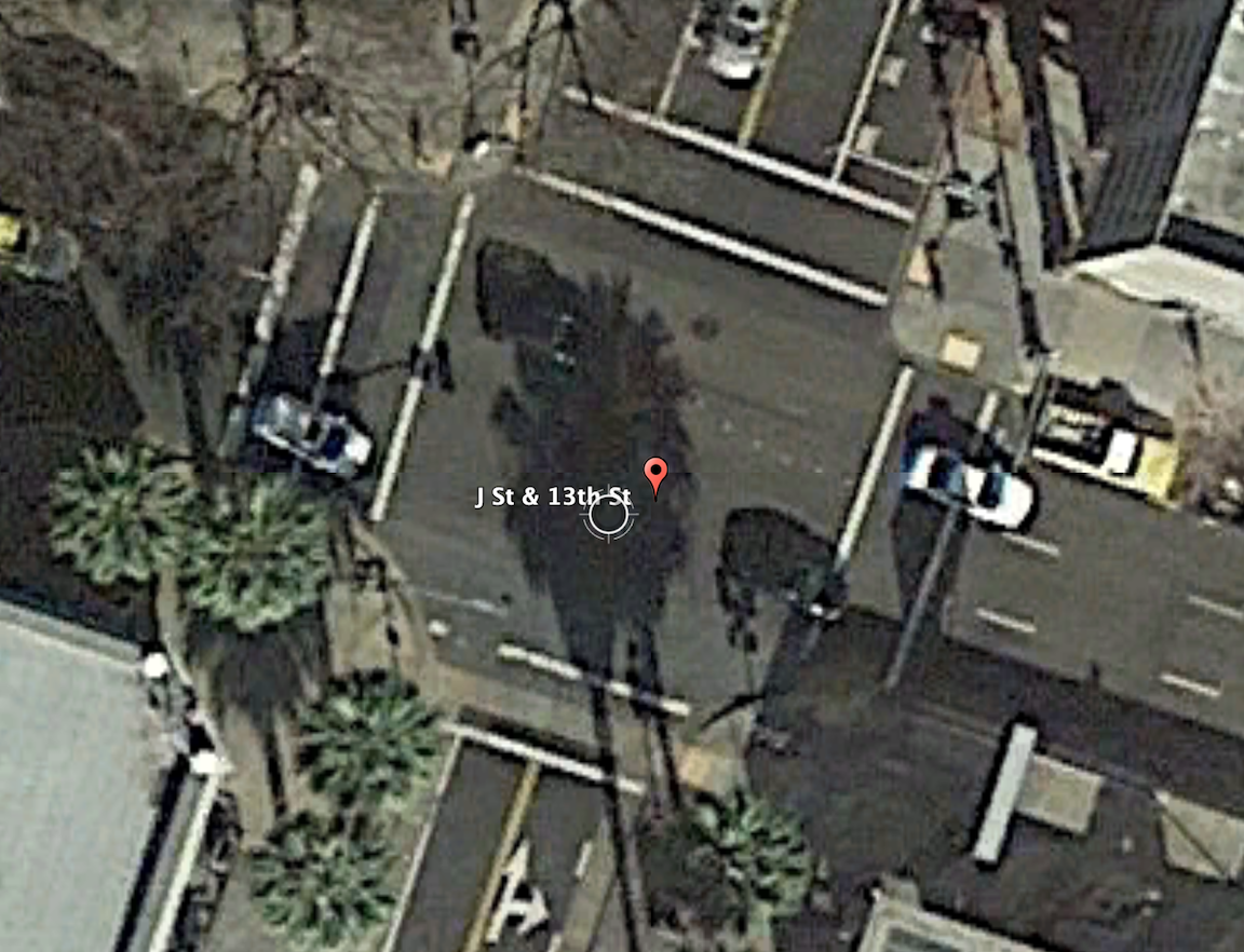
The intersection of 13th Street and J Street in downtown Sacramento is a mess for walkers and bicyclists, largely due to poor decisions that the city has made. The setting is below, with a historical view selected for no leaves on the deciduous trees. On the southeast corner is the convention center, which is under construction now, and the southeast corner is fenced off. On the southwest corner is the Sheraton Grand Hotel. On the northwest corner is a major downtown parking garage, managed by Ace Parking. On the northeast corner is another parking garage managed by Parking.com.
intersection of 13th Street & J Street, downtown Sacramento
In the days before construction on the convention center started and the Sheraton shut down due to the pandemic, this was one of the busiest pedestrian intersections in the central city. The crossing of 7th Street at K Street/DOCO Center, L Street at 11th Street and 10th Street when the legislature is in session, Capitol Mall at Tower Bridge, and a few others are up there, but this one is certainly in the top 10. The city rarely collects pedestrian data, so I do not know what the ranking or volume is.
When the convention center is completed and open, and the Sheraton opens at full scale, this will again become a very busy pedestrian intersection. So you would think that the city would design this intersection and signals to prioritize people walking, but you’d be wrong.
The crossing of J Street on the west leg of the intersection requires pushing the ped button. There are a number of pedestrian signals in the central city that do not require pushing the button, and these are called auto-recall, meaning they automatically change on a cycle. Not this one! I just observed a number of walkers crossing here, and only about 5% of them initially realized they had to push the button. When I mentioned that the signal would never change unless they pushed it, they were surprised, and not happy. When the ped head signal does come on, it has a white hand of 5 seconds, and a countdown of 9 seconds for a total of 14 seconds. There are three lanes of motor vehicle traffic here, lanes about 12 feet wide, for 36 feet. The MUTCD recommended crossing speed is 3.5 feet/second, so 36 feet should be a minimum of 10 seconds, but this assumes that people can leave the curb immediately, not true when the activation button is set well back, and there is pedestrian congestion. In that case, the crossing speed should be 3.0 feet/second. If you want to read about the contortions traffic engineers go through to make walk cycles as short as possible, read pedestrian crossing questions and answers.
The traffic signal for J Street will remain green unless there is a vehicle waiting on 13th Street or someone pushes the ped button to cross. The ped signal to cross 13th Street goes through a white hand, countdown, brief pause, and then back to the next cycle. Without a cross-traffic vehicle or button push, the traffic signal will never cycle. Ever.
crosswalk over J Street at 13th Street
An additional problem is that sometimes the signal controller will just skip the crossing J Street part of the cycle, even when the button is pushed. Since I’m mostly on my bicycle rather than on foot here, I haven’t quite pinned down the behavior. I don’t know if it depends on time of day, or traffic volume, or is just random, but I can affirm that it happens, and not infrequently. So even after the walker presses the button, they may have to wait through another full cycle before they get the walk.
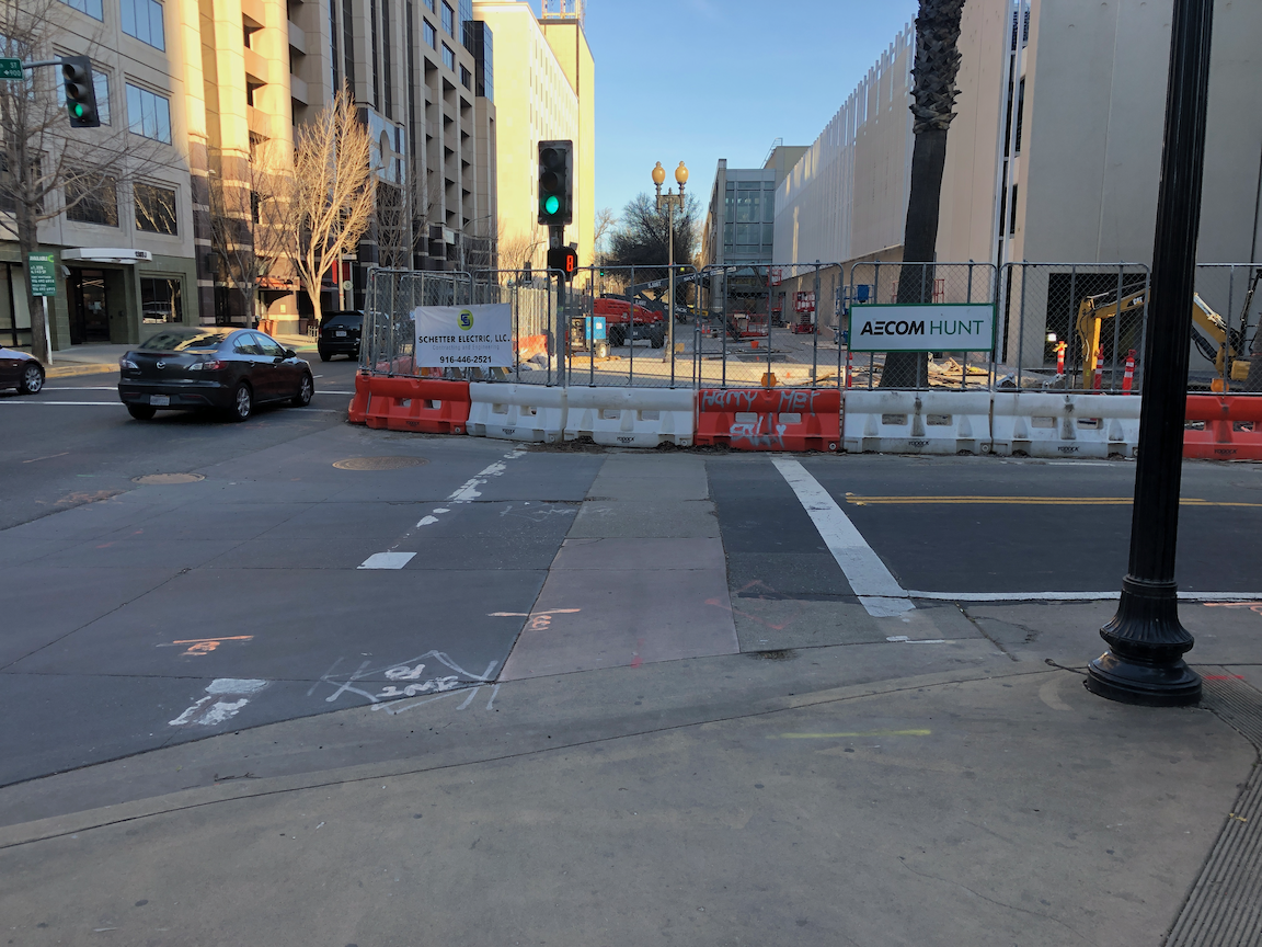
On the southeast corner, the convention center construction has closed the corner and sidewalks. In this situation, there should be a barricade and warning signs on the opposite corner, so J Street south side eastbound and 13th Street east side southbound. A fully sighted person can of course see the barrier and fence across the street, but the point of ADA requirements is to communicate to everyone, not just the sighted. Below is what is looks like, followed by what it should look like. Remember, this is a city project, not a private development, but the city apparently holds itself to lower standards than it holds private developers.
closed crosswalk over 13th Street at J Streetproper barricade and signing for a closed crosswalk, O Street at 8th Street
The east leg crosswalk also suffers from traffic flow design. The walk sign for this crosswalk comes on at the same time as the southbound green signal comes on, bringing drivers into immediate conflict with walkers in the crosswalk. There is no leading pedestrian interval (LPI) to let the walkers get a head start. At this time the crosswalk is closed, but as soon as it is reopened, the conflicts will be immediate, as they have been for years.
Solutions?
Immediately institute auto-recall on the crossing of J Street, and remove the buttons. These are not modern audible buttons, they are antiques.
Immediately institute a leading pedestrian interval on the crossing of J Street, to increase protection from left and right turning drivers.
Immediately lengthen the pedestrian phase for the crossing of J Street to a minimum of 20 seconds.
When then southeast corner of the intersection is re-opened, with completion of the convention center construction, implement an exclusive pedestrian phase for this intersection, in which there is no movement by motor vehicles during the walk cycle, and walkers can cross in any direction including diagonally. If any intersection in Sacramento deserves this treatment, this is it.
Traffic calm J Street to reduce speeds. The most important step is to reduce general purpose lanes to two, and create some sort of bicycle facility. I’m not sure of the best design, as the valet/unloading/loading are for Sheraton Grand may make this challenging.
Get rid of any City of Sacramento Public Works employee who believes the purpose of central city streets is to favor suburban commuters (the J Street traffic) over walkers, bicyclist, and local residents.
I have made at least seven 311 reports on the signal problems at this intersection, asking that it be changed. The only change that I’ve been able to notice is that they lengthened the pedestrian phase for crossing 13th Street, and shortened it for crossing J Street. I just gave up after a while.
Bicyclists
That covers most of the pedestrian problems at this intersection. How about bicyclists? 13th Street is a major bicycle route in downtown, being the only north-south street that crosses through Capitol Park and is not an arterial street, often with heavy traffic and higher speeds. There are bike lanes on much though not all of 13th Street to the south J Street, and there are bike lanes on most blocks to the north, except the half block approaching this intersection. Here, the bike lane has been sacrificed to create a turn lane. There is a required left turn lane and an optional turn lane, but no bike lane. So at this busiest of all intersections on the route, there is no bike lane. There is a clear message here from the city: we will accommodate bicyclists only if it does not reduce motor vehicle capacity. Otherwise, tough luck.
The loop detectors on 13th Street only sometimes detect bicycles. I often see bicyclists during off-times, when there are fewer motor vehicles to trigger the cycle, proceeding through the intersection on red, when it is safe to do so (and occasionally when it is not). They have the right to do so, since by definition a signal that does not detect vehicles (devices) is a non-functional signal, but it is not the best solution.
When the pedestrian button is pushed to cross J Street on the west leg, but no southbound motor vehicles are present, the vehicle signal remains red, so doesn’t allow for undetected bicyclists. This doesn’t protect any walkers, so it makes not sense.
Solutions?
Continue the bike lane on southbound 13th Street to and through (with green skip paint) the intersection with J Street, and remove the left turn lane which prevents the bike lane from continuing. That might mean lengthening the green light for motor vehicles in order to clear the queue.
Install video detection on this intersection that will detect bicyclists on 13th Street so that they don’t have to wait for motor vehicle traffic to arrive and trigger the signal cycle.
Change the traffic signal for southbound to go green at the same time as the pedestrian walk sign. This allows bicyclists to proceed without confusion.
I wrote some while ago about leading pedestrian indicator (LPI) signals, which give the pedestrian a head start of a few seconds before the parallel traffic light turns green. So far as I know, Sacramento has not added any locations to the list of eleven.
But the city should. In fact, I’d argue that any traffic signal where there are a significant number of walkers, and a significant number of turning drivers, should have an LPI. Drivers often fail to yield to people in the crosswalk when turning, or cut in right behind them, and the more chance the walker has to get out into the crosswalk and visible, the better. Of course nothing about the LPI prevents the driver from turning on red, unless turns on red are prohibited. Prohibiting turns on red has been much discussed lately, but I don’t think that treatment is the most important that can happen at intersections.
I live a few blocks from Fremont Park, which is the block between 15th Street and 16th Street, and P Street and Q Street. In fact, many of the parks in the central city are located between pairs of one-way streets, called couplets. 16th is one of the busiest streets in the central city, and the other two are moderately busy, and these four intersections see a lot of turning vehicles. Since I walk nearly every day to and around the park, I get plenty of chance to see how drivers interact with walkers in the crosswalk. I’ve never seen anybody hit, but I often see conflicts, the driver trying to intimidate the walker, trying to beat them to the crosswalk, stopping just short of hitting them, or cutting in close behind them.
P Street and Q Street are two-lane arterials, while 15th Street and 16th Street are three-lane arterials, with higher traffic volumes and vehicle speeds. 16th was a state highway.
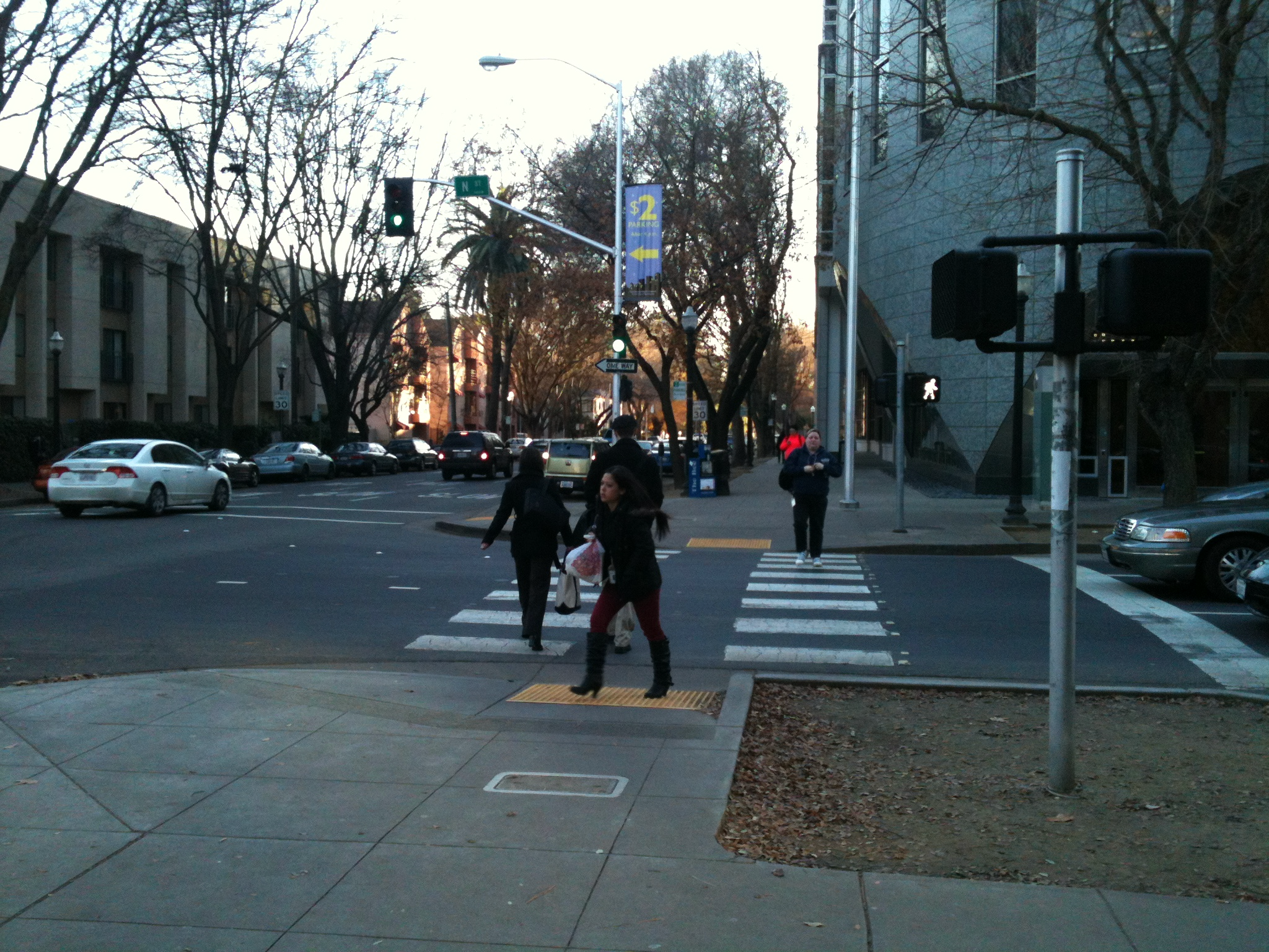
So, I’m asking the city to install LPI signals for the south crosswalk at 15th & P, the east crosswalk at 15th & Q, the north crosswalk at 16th & Q, and the west crosswalk at 16th & P. The photos below show the intersection of 15th & P from pedestrian level, and overhead. The video shows two pedestrians crossing, and mostly through the crosswalk before the driver encroaches. This was a low traffic time with only one turning vehicle. When I have a chance to capture a heavier traffic time with pedestrians, I’ll replace it.
P Street westbound, showing crosswalk over 15th St ahead15th Street & P Street, south crosswalk
crosswalk over 15th Street at P Street
I often write about the Sacramento central city because that is where I live, and I have ample opportunity to observe transportation infrastructure and driver, walker and bicyclist behavior. However, I’d like to state that I DO NOT think that central city issues should be solved first. These issues occur in many places in Sacramento, where the traffic is higher speed, facilities are poorer, and neighborhoods have been disinvested. Drivers in the central city are just as bad as drivers elsewhere, in fact most of them are from elsewhere, the suburbs, but they have grown somewhat accustomed to seeing walkers and bicyclists, and are more careful around them.