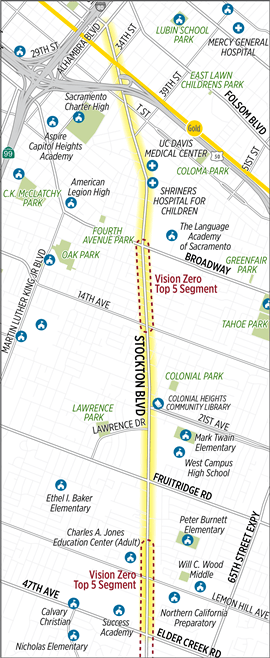
The City of Sacramento is undertaking a Stockton Blvd Corridor Study, covering the section between Alhambra Blvd and 47th Ave / Elder Creek Rd, but focused on the two high injury segments around Broadway to 14th Ave and north of Lemon Hill Ave to south of 47th Ave / Elder Creek Rd. Map below.
Tomorrow, Thursday June 25, there will be a virtual open house at 6:00 pm. There is also a survey which is open through Tuesday, June 30. The survey offers existing conditions information for each of several segments, and then presents two options are asks the user to select one of the other, and make comments if they wish. The options were developed as a result of a community engagement process which was partially led by Jackie Cole of VG Consulting. I attended one of the meetings in February, which had more actual community members than most such meetings, but was only moderately attended. I did not attend any of the other events.
I would encourage anyone who travels on Stockton Blvd, and particularly people who live on or do business on the corridor to take the survey and attend the virtual open house. Please use the comment boxes to tell stories of your personal experiences and concerns using the corridor, as they make a huge difference in the design ultimately selected (we hope).
The nature and width of Stockton (both the street and the right of way) varies considerably over the length of the section, so there is not a single roadway design that can be used throughout.
The survey and background documents do not address the number of driveways along several sections of the road. In some places there are more driveways than not driveways, with each commercial property having one or more driveways. The density of driveways mean that most measures taken to make the street safer for walkers and bicyclists, and faster for transit, will fail. The city must reduce the number of driveways, whereever consolidation is possible. A key question which the survey never asks is what should be the priority of the different travel modes along the corridor. I would argue for:
- transit
- walking
- bicycling
….. - private motor vehicles
But your priorities may be different. The reason I place transit at the top is that SacRT Route 51, when highest ridership route in the entire system, runs on Stockton from Broadway to 47th Ave and beyond. This is the sort of ridership that would justify bus rapid transit (BRT) in most cities, and some of the options do ease bus travel but fall short of BRT. And of course people must either walk or bicycle to the bus, and so these two modes must come next. High quality sidewalks and bike facilities can ease these ‘first mile’ trips, and make it possible to reduce somewhat the frequency of bus stops, further speeding the bus.


[…] is a follow-on the the Stockton Blvd Corridor Study […]
LikeLike
[…] EIR refers all transportation related comments to this document. This plan was a draft in 2021 (Stockton Blvd Corridor Study, Stockton Blvd needs trees, Stockton Blvd draft available). The related project page has […]
LikeLike