Week Without Driving 2024 will be held nationally, and in the Sacramento region, September 30 – October 6. Mark those dates on your calendar and prepare to participate!
A planning committee is meeting once a week to refine details and promotion, so expect to see that showing up shortly. SacRT will be offering free rides to participants on select days.
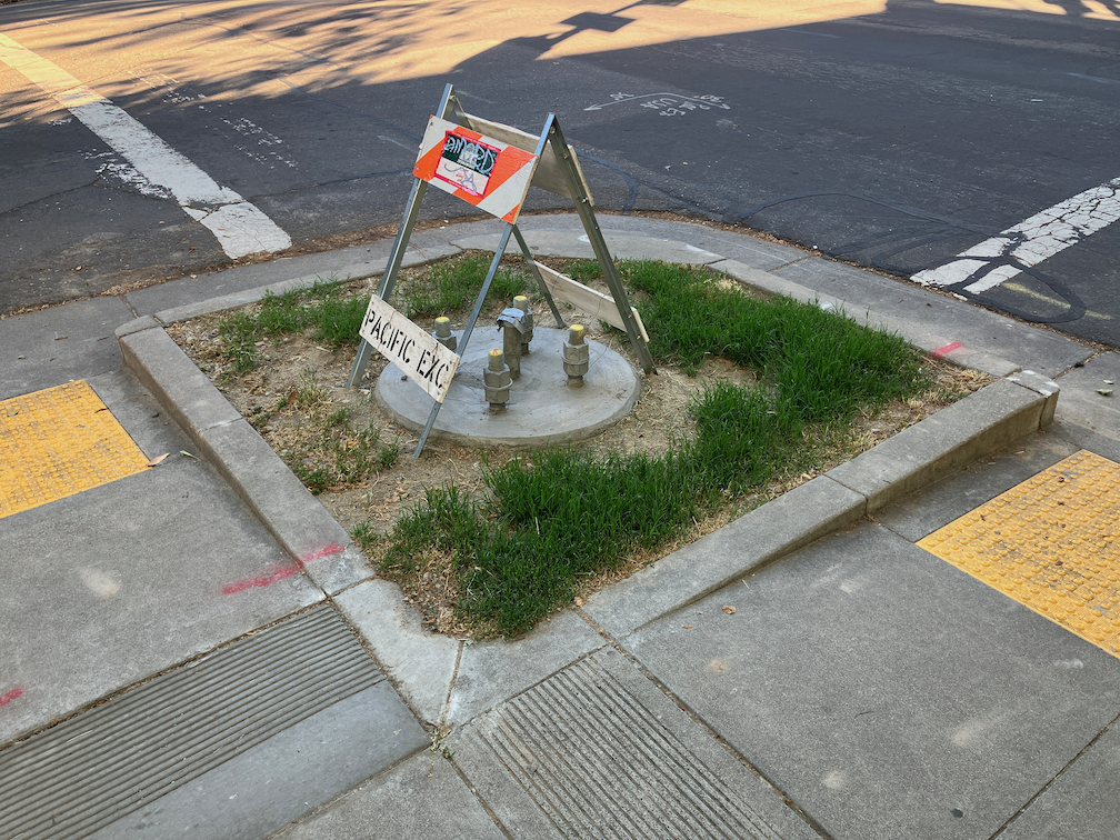
One of the elements of the Central City Mobility Project is the conversion of 5th Street from a one-way, two-lane street, to a two-way, one-lane each direction street. Some work is underway: wiring and signal bases have been installed for the signals necessary for two way traffic at the existing signal locations. Looking at the bases, photo below, I’m guessing that there will be new signal poles and mast arms, not re-use of the existing signals equipment. That seems like a waste of money to me, but the city loves to spend money on new signals, and signal controllers.
I am not sure that many of the current signal locations are even needed. After the conversion, 5th Street will be a lower speed and probably lower volume street. Four-way stops at some major cross streets (such as T Street) might work just fine. Again, the city loves to spend money on signals, and already has unneeded signals at a number of locations (too many traffic signals?).
5th St and T St new signal base
The Central City Mobility Project map shows the 5th Street conversion as extending from Broadway to I Street. The block between Broadway and X Street is already two-way, as are the two blocks between L Street and J Street (the DOCO underpass). It is also two-way north of I Street.
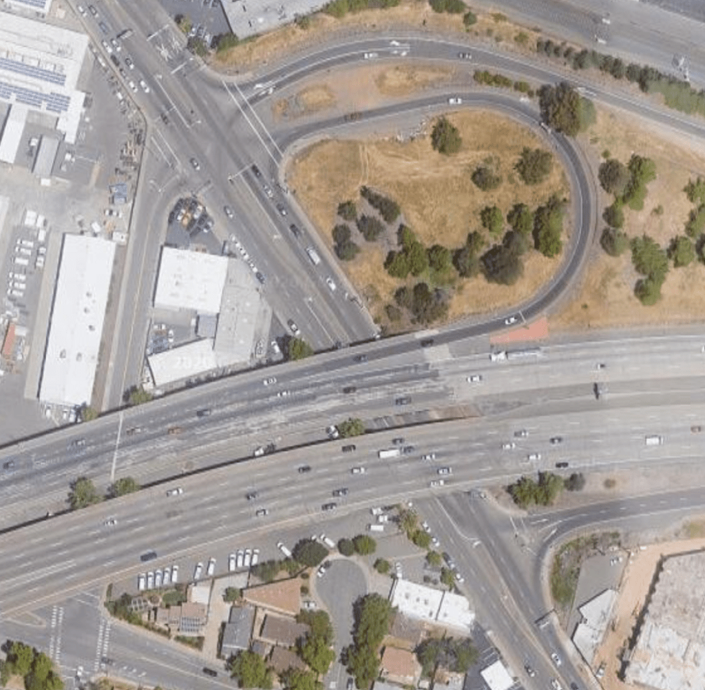
I wonder what, if anything, will be done for the block between X Street and W Street, under the Hwy 50 freeway. This is a very complex block, with a freeway onramp west of 5th Street and a freeway offramp west of 5th Street. The onramp and off-ramp have separate signal phases from X Street and W Street. Traffic westbound onto the ramp, if it makes the green light, is already traveling at freeway speeds, about 65 mph as it crosses 5th Street. Similarly, but not as egregious, the off-ramp traffic, if it makes the green light, is traveling a bit below freeway speeds. I am really not sure how this complex situation can be made safe for bicyclists. Northbound bicyclists only have to deal with drivers running the red light at 5th Street from W Street, but southbound bicyclists would have to deal with multiple turning vehicle movements. In general, the only way to make complex situations like this safe is to have exclusive bicycle phases in which only bicyclists and walkers are moving, no vehicle movement or turns are permitted. But the city is very unlikely to select that safe alternative because it would lengthen the signal cycles and therefore slow motor vehicle traffic to some degree. The city doesn’t want to slow motor vehicle traffic.
The diagram below, from Google Maps, indicates the complexity of this block, but the reality on the ground is even worse.
Measure A 2022, which will be on the ballot this November, is a bundle of old ideas and a commitment to doing things the old way, the way that has dominated our transportation system since World War II. It does not address current transportation challenges. It proposes building more freeways, more interchanges, and widening roadways. It proposes to continue and increase the motor vehicle dominance of our transportation system. Sure, there is a weak commitment to fix-it-first, for the first five years of the 40 years. Sure, there are some complete streets, but that won’t make a dent in the pedestrian and bicyclist-hostile roadways that traffic engineers have built for us.
When Measure A fails, we have a chance in Sacramento County to identify and implement progressive and effective transportation projects and systems. What would a better transportation system look like?
One not so dependent on sales taxes. Sales taxes are regressive – low income people spend a much higher percentage of income on sales tax than do higher income people. Property taxes and congestion charges are a much fairer way to fund transportation. We have been too dependent on sales tax, for not just transportation, but many government functions.
One that recognizes and works to overcome the disinvestment that low income and high minority communities have suffered. Our transportation system is largely designed to ease the commutes and travel of high income individuals, not of society as a whole. The light rail system was designed with the needs of suburban, largely white commuters. So too were our freeways. At least 70% of transportation expenditures should be in and for the benefit of disinvested communities.
We have all the lane miles and pavement we will ever need. It is time to stop adding lanes miles and stop adding pavement. Not just because of the climate implications, but because these are low-return investments. Instead, transportation expenditures should support walking, bicycling and transit.
Big transportation projects such as freeways and interchanges claim big job benefits, but they are in fact much less efficient at generating high paying jobs than many other types of infrastructure investments. New construction spends most of its funds on materials, not on labor. The construction companies make large profits on large projects, but little of that filters down to workers. Small to moderate projects would employ many more people.
A transportation system dependent on motor vehicles, whether they are fossil fueled or electric, has strongly negative impacts on our places: direct air pollution, tire dust pollution, noise, traffic violence, loss of land to parking and roadways rather than productive development, and probably most important, it intimidates people out of walking and bicycling. A transportation system based on walking, bicycling, and transit eliminates most of these negatives.
A car dominated transportation system pushes everything further apart, jobs and housing and shopping and medical far away from each other. Cars not only encourage but largely demand low density development, so that there is space reserved for cars, all the parking and roadways that take up a large portion of our cities. It requires a car to participate in society, and thereby requires low income people to expend an unsustainable percentage of their income on transportation. A transportation system that relies much more on walking and bicycling allows things to be closer together, so that cars are not necessary for most daily travel.
Transportation investment should depend much less on state and federal funding, and much more on local funding. Large portions of the Measure A funds are intended to be matches for grants. But grants cause planners to focus on what the state and the federal government want, not on what the county or cities need. When the income from taxes or fees is close to the people, the solutions are much more likely to be what is desired by the people.
Private vehicle travel does little to contribute to making our places and our lives better. A innovative transportation system would focus on access to services, and make those services available nearby. It would reduce vehicle miles traveled, both by changing our development pattern and by actively working to reduce motor vehicle travel.
Our current transportation system has destroyed a lot of natural and agricultural lands, paving it over with roadways and low density housing. The best way of preserving nature and agriculture is to focus our attention and our funding on already higher density areas, which means infill.
None of the projects in Measure A are designed to support infill development. A progressive transportation system would focus nearly all investment on infill areas. It would cost much less money, and be much more productive.
Measure A calls out and essentially requires completion of the Green Line light rail to the airport. But who will use it? Unless service hours are 24 hours a day, it won’t be usable for many of the airport workers, who work before and after peak travel times. Instead, it may become yet another very expensive service for high-income travelers, just like our freeways system. Instead, we need to rethink our transit system to determine what citizens want and will use, and build a more efficient system around that. We know that frequency is freedom, so we must shift spending towards that, even while maintaining a reasonable level of areal coverage.
I’m sure you can think of many other things that an innovative, equitable transportation system would accomplish. Please suggest!
The City of Sacramento preliminary draft Climate Action and Adaptation Plan (CAAP) was on the agenda of the 2022-08-16 city council agenda, with a workshop on carbon neutrality. The council had asked staff for a status report, and to bring ideas for accelerating reaching carbon neutrality sooner than the original target date of 2045.
The staff presentation presented a few things that had happened before completion of the plan. Staff focused, as does the plan, on buildings and EVs. Ryan Moore of Public Works talked about transportation projects, but did not mention policy. Jennifer Venema presented several acceleration ideas, but they were vague. One was the build-out of the bicycle master plan, as though it was that, or everything else. The slides used by the staff presentation have not been made available to the public.
Almost everyone who spoke on the agenda items, on Zoom and in person (this was the first in-the-room council meeting), spoke in support of achieving neutrality sooner, and taking serious actions rather than the mild actions suggested by the plan. I am really proud of the citizens and organizations that took the time to formulate thoughtful statements and to wait for their turn.
Some of the council members spoke. Katie Valenzuela was the only one with a substatiative idea (see below), the others just offered platitudes. Darrell Steinberg unfortunately went off on a long rant in support of the transportation sales tax measures, including the lie that it had been amended. The side agreement between SACOG and SacTA has not been approved, and the language of the ballot measure has not changed at all – it is still bad news for the climate.
Katie Valenzuela’s slide
I made the following statement:
“Transportation is 57% of carbon emissions in Sacramento. Equitable transportation is what we should be talking about.
Transportation priorities, carried over from Mayors Commission on Climate Change:
Active transportation
Transit
Electrification of remaining motor vehicles
The CAAP seems to invert that priority, and is strongly focused on EVs, which would retain the motor vehicle dominance of our transportation system.
Active transportation should be first and foremost in the CAAP.
Why is active transportation so important to transit? Because that is how people get to and from transit. Both are important to an effective response.
$510M for a full buildout of the bicycle master plan is a fraction of what is already being spent on motor vehicle capacity expansion. For example, the Fix 50 projects is estimated at $433M, but will probably come in much higher.
Deb Banks mentioned that the bicycle master plan needs an update. The pedestrian plan, however, dates from 2006, and is completely out of date. Yet the CAAP does not even mention updating those documents nor combining them into an active transportation plan.”
The first City of Sacramento Transportation & Climate Workshop was held last night as part of the regular city council meeting. The first news, which was not at all clear before, is that this is the first of several workshops, which will develop the plan further. The next workshop has not been scheduled, but may be in March.
screen capture from city presentation
Some highlights:
No one spoke against the seven big idea projects.
People liked the enhanced bus lane on Stockton for SacRT route 51, but it didn’t receive much notice in the discussion.
Nailah Pope-Harden of Climate Plan and a local activist, said bold is the minimum, and said all projects should be about reconnecting communities. Many other speakers referred back to Nailah’s challenge.
The opening slide of the city presentation showed SacRT bus route 30 on J Street, pulled out of traffic and blocking the bike lane. Irony probably unintentional, but it does illustrate one of the ways in which the city does not support transit or bicycling. The bus should not be pulling out of traffic, but stopping at a bus boarding island with the separated bikeway running behind it.
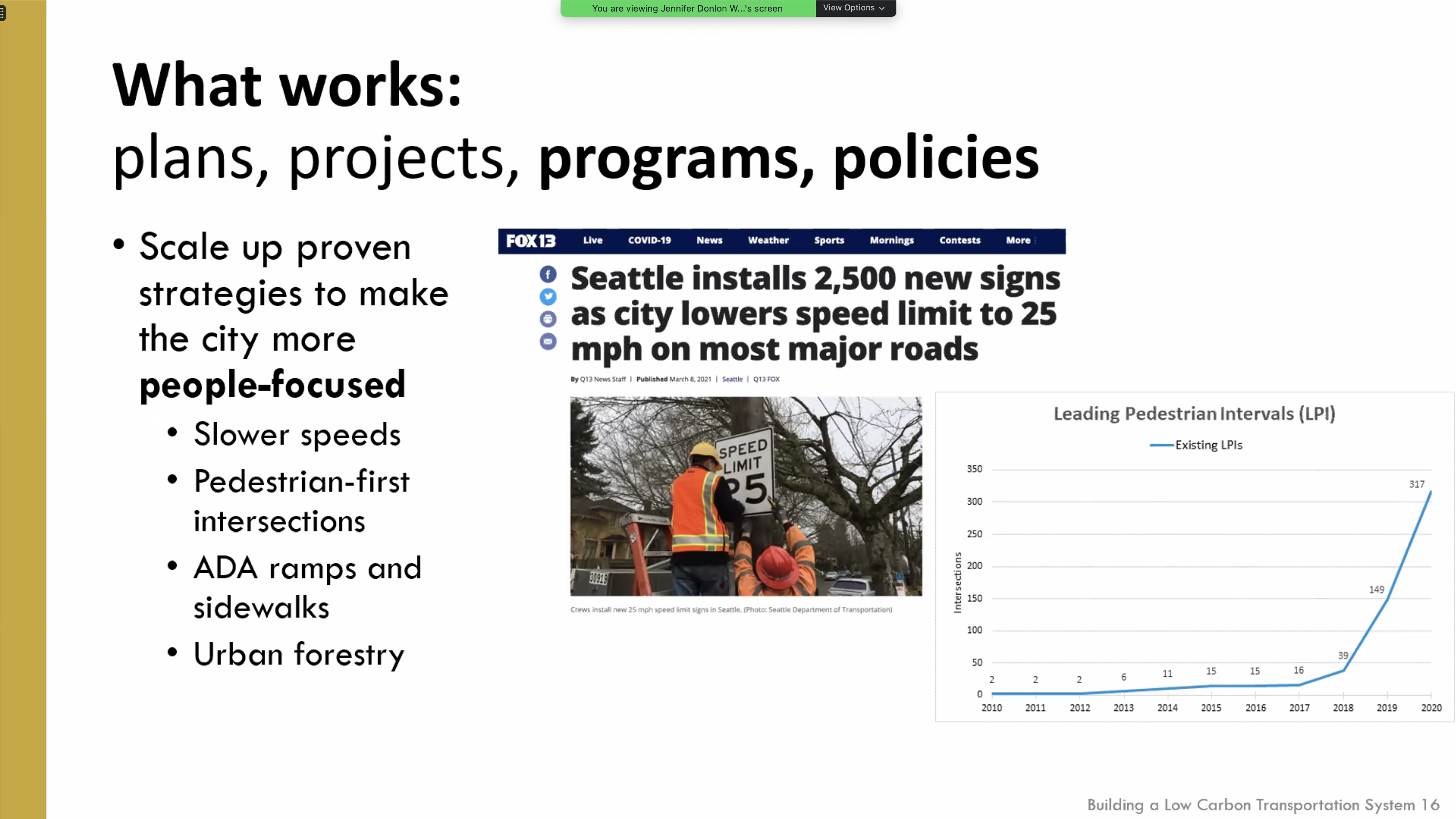
Sam Zimbabwe of Seattle DOT presented on the ways in which the city has shifted mode share to transit with projects and priorities. One of his slides showed the huge increase in the number of intersections at which they have programmed leading pedestrian intervals (LPIs) to enhance pedestrian safety.
Jeff Tumlin of San Francisco MTA said they have realized that waiting for a few big projects is an ineffective approach, and are now doing many small projects, often with temporary measures that can be improved when made permanent. He said that sales taxes don’t have to be regressive, if the benefits are directed to the right places and projects, and that well-designed congestion pricing is not regressive. He also suggested that city staff should be challenged to a higher level of productivity and innovation, and let go if they choose not to meet that. He also spoke about SFMTA’s approach, with partners, of working on transportation and housing as a unified goal, not siloed.
Darrell Steinberg mentioned several times the idea of the city doing a transportation ballot measure so that it could set its own priorities for investment rather than compromising with the county (SacTA) over projects which don’t meet the needs of the city.
City staff said transportation is now 56% of carbon emissions in the city, which is higher than numbers reported before.
Ryan Moore poo-poo’d the idea of lowering speed limits, saying the MUTCD prevents that, without mentioning the state law which allows reductions in specific circumstances. Others pushed back on this.
Rick Jennings spoke enthusiastically about getting more kids on bikes and his own experience of bicycling with kids.
Jeff Harris spoke about EVs, despite the setup of the workshop being about other transportation ideas, not EVs.
Mai Vang pointed out that the ideas are too District 4 (central city) focused, believes that there should be more focus on low-income and outlying areas. She said we need better access to light rail stations, not just bicycling access to downtown.
Civic Thread spoke (all their employees!) about the need for a city-wide Safe Routes to School program to address the recent parent death at school dismissal at Hearst Elementary, as well as safety needs at every school. They also highlighted equity and community access.
Henry Li and Jeff Harris pointed to micro-transit (SmaRT Ride) as being a great success, but SacRT has still not provided information to the community to judge that.
Henry Li spoke mostly about funding, and did not address the Stockton/Route 51 project. He again highlighted light rail to the airport, despite the transit advocacy community’s request that all light rail extensions including ARC/Citrus Heights/Roseville considered before selecting the next project.
The message from the invited speakers and the community was clear: we need to make big changes in a hurry, and city funding and commitment will be necessary for that to happen. How will the city respond?
What are your highlights from the workshop?
screen capture of Seattle DOT slide on speed limits and LPIs
Following the online virtual open house, I realized I could not picture the situation on some segments of Stockton. Though I’ve traveled Stockton many times, I had not in a while, so I went back. I had commented during the open house, as well as after, that I didn’t think the cross-sections presented gave enough information on or weight to trees, so that was part of my agenda, to see the tree situation better. The day I went, last Sunday, was one of the cooler days in a while, high of 80 degrees Fahrenheit, but on the street the lack of shade and heat was noticeable. Add 20 degrees, and it would be intolerable for walking and unpleasant for bicycling.
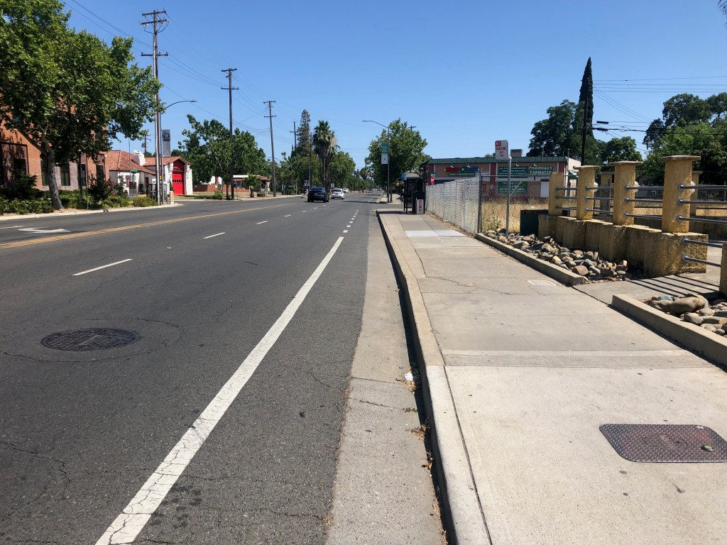
The tree situation is not good. There are some sections with healthy trees, and some places where trees on commercial properties are healthy and shade the sidewalks, but on the whole, trees are lacking. The first photo below, taken looking south, to the south of Broadway, shows a long section with no trees at all, no buffer, no shade. The sidewalk is wide enough, but who would want to walk here?
Stockton Blvd south of Broadway
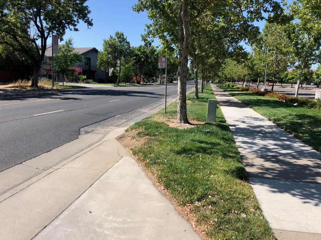
The next photo is of the section adjacent to UC Davis Medical Center where trees are present in a slightly too narrow buffer. The trees are relatively young, but when mature, will provide necessary shade and probably also crowd the buffer.
Stockton Blvd near UC Davis Medical Center
The next photo is of a very narrow strip where trees were present but were all cut down, and the following photo, a Google streetview capture of the trees. The trees were obviously planted in a strip far too narrow for them, and some of them were unhealthy as a result, so I’m not presenting this as a model, but as a warning that commercial properties cannot be relied upon to provide trees. Even the small trees in this narrow strip provided some shade and feeling of place to the street. In addition to this instance, there are many commercial properties and some residential properties along Stockton where the trees are dying, dead, or have been removed. And conversely, some where the trees on commercial properties are in good condition, so thank you to these properties. Trees, if they are to serve as a long-term amenity, as I believe they should, must be provided in the public right of way and maintained by the city.
Stockton Blvd, removed trees, near JansenStockton Blvd, trees before removal, near Jansen
A small archive of photos from Stockton Blvd are available in the Flickr album at the end of this post, and those who live along or do business along can provide more detail.
So what is the solution? The first part of the solution is that the city must modify its cross-section renderings and pages so that it highlights the tree situation. Will there be a sidewalk buffer? How wide? What numbers and kinds of trees? To what degree will the project rely on trees on private property, versus trees in the public right-of-way? I find the options presented as unacceptable because they don’t really address this issue. On a few of the pages, trees are mentioned, but never in enough detail.
I would propose for community along Stockton Blvd that there should be continuous sidewalk buffers planted with trees, all the way from Alhambra to 47th Ave/Elder Creek Rd. Where buffers are present with trees, great, make sure they are preserved and cared for. Where buffers are present but the trees are absent or unhealthy, plant new trees and care for them. Where there are no buffers, create them, and plant trees and care for them. Where there is a healthy tree line on private property, this can serve for now, but the buffer should still be provided for the protection of walkers and as a bulwark against possible abandonment of the private trees. I envision Stockton Blvd being a tree-lined community asset, where walking is a pleasure and traffic speeds and volumes are low.
For new buffers, the minimum width of the buffer should be eight feet, as anything narrower does not allow for full development of the trees, and leads to excessive root heaving of the sidewalk. The heaving is to some degree an inevitable consequence of having trees, but wider buffers and correct watering regimes reduce the problem considerably. Where the existing buffers are at least six feet and the trees are healthy, the buffer can be widened or left as is, depending on the situation. Where the buffer is narrower than six feet, the buffer must be expanded.
Where commercial businesses are present and buildings meet the sidewalk, the trees should still be present, but the spacing and species can be adjusted in consultation with the property or business owners so that they don’t block off visibility of local businesses. In most cases the buffer would be paved, with tree wells for the trees, and street furniture or other amenities in the buffer, but the buffer would still be a minimum of eight feet.
Intersections
Another issues that the city diagrams and information do not address is intersections and crossings. The existing conditions report acknowledges that there are long distances between safe crossings on the south end, but doesn’t provide much detail about intersections.
The intersections as they exist actively discourage pedestrian activity. The midblock crossings, of which there are a few, do not have any additional protection. At a minimum, these locations need user-activated RRFBs (Rectangular Rapid Flashing Beacons). At many of the signalized intersections with minor streets, there is a pedestrian prohibition on either the north or south leg. These prohibitions exist solely to speed the signal cycle and encourage traffic flow; they do not exist for safety reasons. They must be removed. The photos below shows just one of the many such prohibitions. A person walking on the south side of Jansen, wanting to go south on Stockton, would have to use two crosswalks, waiting for the signal, and then walk through an overly wide commercial driveway. There is no reason for this.
Stockton Blvd at Jansen Dr, pedestrian prohibition
At the major intersections, where crosswalks are present on all legs, the crossing distances are long. Though not as bad as many other locations in Sacramento, intersections are often flared out to add turn lanes, both left and, often, right turn lanes. This increases crossing distance. This issue can be solved in two ways: removing the unnecessary turn lanes, or adding pedestrian refuge islands in the middle, so that slower walkers can make the crossing in two stages. The medians must be six feet wide, to meet standards, and must have a pedestrian button so that people don’t become stranded. (Note: I’m not in favor of pedestrian buttons at all, except when they: 1) trigger audible information, or 2) lengthen the crossing time; however, this is one situation in which they make sense)
The project information does not really address intersections at all. City staff said that these details would be worked out later, but I find this unacceptable. Intersection design must be part of the options presented. Intersections are where most conflicts occur between pedestrians and vehicle drivers, and bicyclists and drivers as well, so they are a critical element of any effort to improve Stockton.
Driveways
Some of the sections of Stockton are littered with driveways. Each commercial property has one to several. Part of improving Stockton must be to reduce the number of driveways. Each commercial property should have one driveway, or less. One of (the only) advantages of the parking moats that front the street (what I mean by parking moat is that the commercial buildings are set back away from the street, and parking lots face the street; these parking moats contribute significantly to the feeling of Stockton Blvd being a car-dominated place). In several cases, these parking moats can be combined for several properties in order to reduce the frequency of driveways. The issue with driveways is that they not only make a place feel busy and unwelcoming to walkers and bicyclists, but they are safety hazards for walkers and bicyclists very nearly as bad as the hazard of an intersection.
Stockton Blvd, north of Elder Creek, excessive driveways
Built Form
There is a section of ‘old’ Stockton Blvd where the buildings come to the sidewalk, and parking, if any is to the side or back. This traditional pattern (traditional before suburban sprawl) is the best built environment, the one that feels most welcoming to people outside cars. It increases customers, it makes the street feel smaller and the sidewalk feel larger.
The ‘new’ sections of Stockton Blvd where buildings are set back behind a moat of parking have exactly the opposite effect, producing an environment that feels unwelcoming to walkers, makes the sidewalk feel like a part of the street rather than a part of the neighborhood. This built form is a widely recognized mistake, but the correction will take many, many years as these commercial properties evolve. But what can happen, now, is that all new commercial buildings can be required to front the sidewalk. There are a lot of empty or abandoned parcels on Stockton, which everyone hopes will see new development. That development should be the traditional pattern that gives the street a neighborhood feel rather than a traffic sewer feel.
Stockton Blvd, buildings fronting the sidewalk
Speed Limits
Another issue that the study pays scant attention to is speed limits. Whether or not the street design option work depends on design speed and posted speed. The default assumption in transportation planning is that speed limits cannot be lowered, due to California ‘law’. First, it is not a law, it is case law, established by judges, not the legislature, that says traffic tickets won’t be enforced unless speed limits are set to the level at which only 15% of drivers exceed. This will of course be changed, but the process is long, with powerful opponents, most specifically CHP whose lip service to safety is legend. But more important to this study is that streets that are reconfigured, with a change to lane width or number of lanes or mix of modes, can be set to any speed limit the city wishes. The road is new, and the past speed limit doesn’t apply.
So, in accordance with my desire to see a tree-lined neighborhood boulevard, I think that the speed limit for this entire length should be 30 mph. And of course the street must be designed to enforce that posted speed limit.
Highway 50 Interchange
The Hwy 50 and Stockton Blvd interchange is problematic for both walkers and bicyclists. There are no bike lanes through this section, at all, and walkers on the east side of Stockton face long crossing distances in a design that strongly favors high speed motor vehicle drivers. In the photo below, look at the long crossing distance on the north side of the freeway, of the exit and entrance ramps. It’s about 120 feet, with no protection from drivers, at all. I have both used and observed this crosswalk, and can confirm that very few drivers yield to walkers in the crosswalk. It is a guaranteed death trap for walkers.
The roadway striping does not delineate areas for motor vehicles and bicyclists, nor does it indicate where riders or drivers should be merging to reach their destination. It is just a wide-open area, and as with all wide-open areas, drivers will assume they have complete right-of-way. You can see by the tire tracks that the turns on and off the freeways are being taken at high speed.
Stockton Blvd – Hwy 50 interchange
This interchange must be completely reconfigured for the safety of walkers and bicyclists, and drivers for that matter. The entry and exit ramps must connect with the street at 90 degree angles, requiring drivers to make low speed turns. Bicycle lanes with green conflict markings must be installed throughout the interchange. Sidewalks must be improved and crossing distances shortened to no more than 22 feet.
It is disappointing that such a critical safety hazard was not addressed in the study.
Mode Share
The study, online survey, and open house never address the key issue for the entire corridor, which is: what should be the priority of travel modes in design of the street? Some of the options imply a higher priority for some modes than others, but the critical question is never asked of the public. I had said in my previous post that my priorities would be transit first, then walking, then bicycling, then private motor vehicle travel. However, having spent more time looking at and thinking about the corridor, I’m going to change that. The priorities should be walking first, strongly supported by the tree-lined boulevard configuration I’ve outlined and justified, then transit, then bicycling, then private motor vehicles.
What is is important here, though, it not my preference, but that the public, and in particular the residents and customers along the corridor were never asked this question.
What Now?
I’ve laid out what I consider some major flaws in the study. I am not against the particular options that were presented, and from that limited perspective, the study has done a good job. But the number of things NOT considered is glaring. I know the city hopes to address these issues later, but I don’t find later to be acceptable. The public needs a full set in information now, so that it can comment on the study from a perspective of understanding how the street will feel after the changes, not just design diagrams, but how each traveler will get along and across the corridor, and whether it supports their desires for mobility and livability.
I think the city should pause the study process and add in the elements not addressed, then go back out to key stakeholders, and re-do the engagement process including the survey and open house.
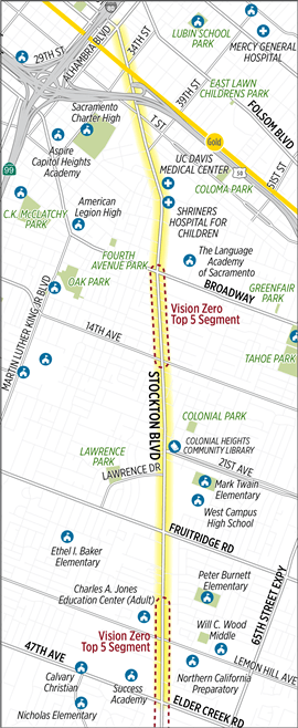
The City of Sacramento is undertaking a Stockton Blvd Corridor Study, covering the section between Alhambra Blvd and 47th Ave / Elder Creek Rd, but focused on the two high injury segments around Broadway to 14th Ave and north of Lemon Hill Ave to south of 47th Ave / Elder Creek Rd. Map below.
Tomorrow, Thursday June 25, there will be a virtual open house at 6:00 pm. There is also a survey which is open through Tuesday, June 30. The survey offers existing conditions information for each of several segments, and then presents two options are asks the user to select one of the other, and make comments if they wish. The options were developed as a result of a community engagement process which was partially led by Jackie Cole of VG Consulting. I attended one of the meetings in February, which had more actual community members than most such meetings, but was only moderately attended. I did not attend any of the other events.
I would encourage anyone who travels on Stockton Blvd, and particularly people who live on or do business on the corridor to take the survey and attend the virtual open house. Please use the comment boxes to tell stories of your personal experiences and concerns using the corridor, as they make a huge difference in the design ultimately selected (we hope).
The nature and width of Stockton (both the street and the right of way) varies considerably over the length of the section, so there is not a single roadway design that can be used throughout.
The survey and background documents do not address the number of driveways along several sections of the road. In some places there are more driveways than not driveways, with each commercial property having one or more driveways. The density of driveways mean that most measures taken to make the street safer for walkers and bicyclists, and faster for transit, will fail. The city must reduce the number of driveways, whereever consolidation is possible. A key question which the survey never asks is what should be the priority of the different travel modes along the corridor. I would argue for:
transit
walking
bicycling …..
private motor vehicles
But your priorities may be different. The reason I place transit at the top is that SacRT Route 51, when highest ridership route in the entire system, runs on Stockton from Broadway to 47th Ave and beyond. This is the sort of ridership that would justify bus rapid transit (BRT) in most cities, and some of the options do ease bus travel but fall short of BRT. And of course people must either walk or bicycle to the bus, and so these two modes must come next. High quality sidewalks and bike facilities can ease these ‘first mile’ trips, and make it possible to reduce somewhat the frequency of bus stops, further speeding the bus.
In all my spare time, which means while commuting to work on my bike, I think about state legislation I’d like to see. Here is my list of the moment. Feel free to add suggestions.
Bicycling
Remove far-to-the-right bike lane provisions, CVC 21202
Flip parking in bike lanes from permissible unless posted to prohibited unless posted
Require that all signals detect bicycles within two years
Be explicit in CVC that placing waste containers in bike lanes is the same violation as leaving any material in a travel lane
Require that all waste containers be inscribed with ‘do not place in bike lane’, and have reflective stripes on the sides of the container
Implement ‘Idaho stop law’ (yield as stop) for stop sign controlled intersections
Pedestrians
Require full traffic studies for the removal or crosswalks or prohibition of crossing, with the default position being that crosswalks will not be removed and prohibitions will not be created or continued
Remove the prohibition on pedestrians crossing the street between signalized intersections on all streets 30 mph or less
Speed
Change the prima facie speed limit for residential and commercial streets (local) from 25 mph to 20 mph; change to 20 mph or less for posted school zones
Set the maximum speed allowable on collector streets to 30 mph; set the maximum allowable speed on arterial streets to 40 mph
Allow automated speed enforcement everywhere
Schools
Require law enforcement to send incident reports involving children going to or from school to school districts within 24 hours of completion, and investigations within 72 hours of completion
Prohibit U-turns within school zones
K-12 school districts and colleges/university would be required to have transportation demand management programs, since school-related traffic is a significant portion or overall traffic
Other
Shift the burden of proof to the motor vehicle driver for all collisions with pedestrians and bicyclists involving fatality or severe injury
Allow any citizen to challenge the professional license of an engineer who is aware of a traffic safety hazard and fails to request funding to mitigate that hazard
Decriminalize transit fare evasion
Allow conversion of any and all freeway lanes to toll
His main point is that those calling for balancing spending on all the modes really mean “lets just keep doing what we were doing.” We have spent, in this region, trillions of dollars in support of one mode, the privately owned motor vehicle. We have spent a little on transit, and almost nothing on walking and bicycling. If we simply increase the share for transit, walking and bicycling a bit, we have not really done anything. There is a deficit in transit, walking, and bicycling that can only be overcome but shifting our spending to these modes. Every dollar spent on expanding or widening roadways and freeways for privately owned vehicles directly harms transit, walking and bicycling because it encourages and subsidizes privately owned vehicles. It encourages people to live further away from jobs and services. It induces traffic, which congests our roadways so that transit can’t work as well. It encourages inappropriate speeds that endanger walkers and bicyclists.
Before we can start doing right, creating system that truly serves people’s desires for access in livable communities, we have to stop doing what we were doing. It think we can keep doing the wrong stuff and just add in the right stuff, we are wrong. We need to stop expanding and widening roads. Now, and for ever. #NoNewRoads
SACOG is working on the 2016 update of the MTP-SCS (Metropolitan Transportation Plan / Sustainable Communities Strategy) or Greenprint, with the draft having been out for a month and the deadline for comments on November 16. The last of the public meetings will be held tomorrow, Tuesday, November 10, 6:30-7:30PM, at SACOG Offices, 1415 L Street, 3rd Floor, Sacramento. I hope you can attend.
I have been part of a 350Sac Transportation Committee effort to review the document. I’ve reviewed parts of it, Chapters 1, 4, and 5C, and Appendix A, but have not had the time to review the whole thing – it is massive. The comments below are my own, not the committees. Your comments on the plan are welcome and important. If you can’t tackle the whole plan, pick a small part of interest to you, and comment on that part.


 SACOG is working on the 2016 update of the