Marysville Blvd VZ Phase 1 complete

This post updates the Marysville Blvd VZ Safety Project starts post from March 2026. The Phase 1 quick-build project is complete.

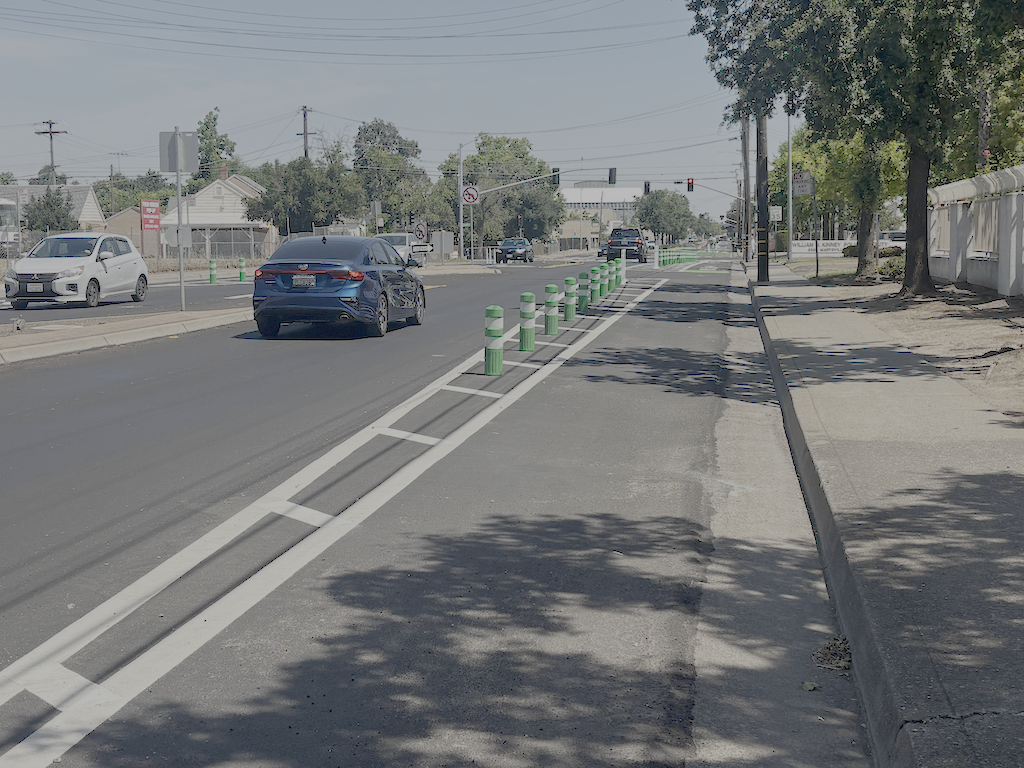
Northbound, the project starts just beyond Los Robles Blvd, and ends at Grand Avenue. Southbound, the project starts just beyond Harris Avenue, and ends just beyond Nogales Street. The focus of the project is narrowing the roadway from four lanes to two lanes with adjacent bike lanes or separated bikeways. Some bicycle facilities are just paint on the ground, while some stretches use vertical delineator (both green K-71 and white ‘wands’ with bases). A typical section is below. The bike lanes at the north and south ends are of poor quality, depending on the gutter pan with a strong linear seam to achieve minimum width. In the middle section, the quality varies but is mostly acceptable.

photo of Marysville Blvd northbound, north of Rosalind St, separated bikeway with K-71 delineators
Marysville Blvd northbound, north of Rosalind St, separated bikeway with K-71 delineators

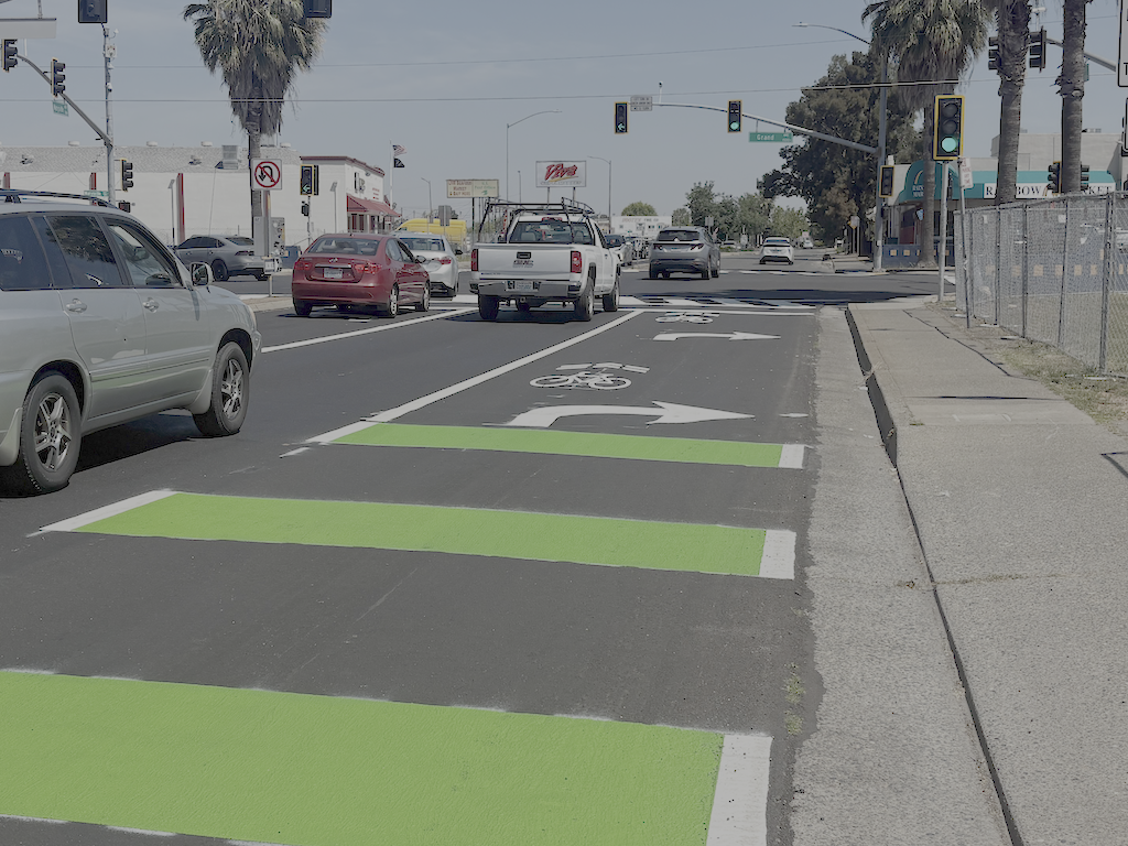
The project uses shared bike lane/turn lane areas at Grand Avenue, below. This is not the worst design, placing bike lanes to the right of right-turning vehicles, but neither will it be comfortable for many bicyclists.

photo of Marysville Blvd northbound at Grand Ave, shared bike lane and right turn lane
Marysville Blvd northbound at Grand Ave, shared bike lane and right turn lane

Observing motor vehicle traffic on a Saturday, it appears that drivers have adjusted to the change. Though the varying treatment of the right-of-way might be confusing, it seems to be handled OK. The only issue is that a police motorcycle used the bike lane to bypass traffic, and almost hit me. I did not see anyone bicycling along Marysville, though I did see a number of bicyclists crossing Marysville at side streets.

The signal faces at Marysville Blvd and Grand Avenue were replaced. Other signals were not changed, so far as I can determine. One of the signal faces for Marysville northbound at Grand is out, probably due to mis-wiring.

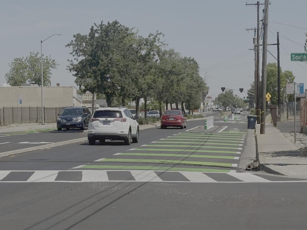
SacRT bus Route 86 runs on this section of Marysville Blvd. Bus stops were marked with dashed (skip) green markings for sharing with bicyclists, below. I suspect the bus area is not long enough for bus use, but since I did not see an buses along the route today, I’m not sure. The bus only runs once per hour on Saturdays. I think the design is safe for bicyclists since it is such a clearly marked area. The only better design would be a bikeway behind (curb-side) from a bus boarding island, though with only one lane for motor vehicles, the city is very reluctant to have buses stop in traffic. I’ve got not problem with it, transit riders have no problem with it, but engineers just can’t stomach giving priority to buses.

photo of Marysville Blvd shared bus and bike area
Marysville Blvd shared bus and bike area

No improvements to sidewalks were made, not even corner curb ramps at the most critical intersection of Marysville Blvd and Grand Avenue.

This section of Marysville Blvd is characterized by:

  • moderate to poor sidewalk conditions and width
  • sidewalk cross-slopes at nearly every driveway, which is a hazard for mobility devices and many walkers
  • abandoned business building, and abandoned parcels that may have once been occupied by businesses or residences
  • an excess for driveways, most of are not in use; a number of the parcels have two or more abandoned driveways; even the City of Sacramento Hagginwood Park has an abandoned driveway

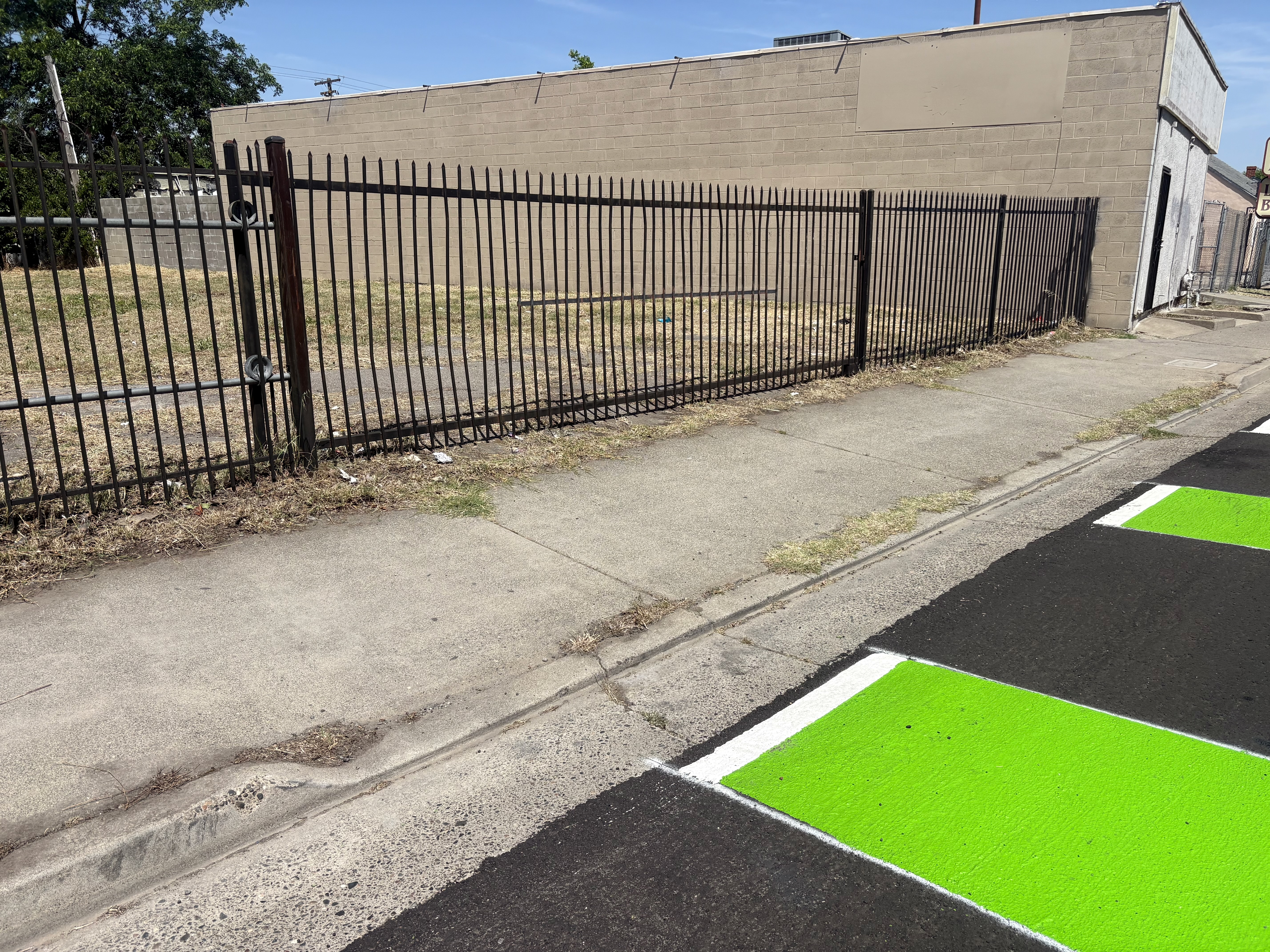
One example of a driveway that slopes across the sidewalk is below. There are dozens of locations just in this section of Marysville, to say nothing of north and south of the project. Some are active driveways for commercial buildings and residences, but probably at least one-third are abandoned, serving no purpose whatsoever except to make the walking/rolling experience less pleasant and more dangerous.

photo of 3617 Marysville Blvd, abandoned driveway with cross-sidewalk slope
3617 Marysville Blvd, abandoned driveway with cross-sidewalk slope

The project has done nothing to improve the walkability of Marysville Blvd.

The signal which seems to be most confusing to walkers and drivers is the partial signal at Los Robles Blvd on the east and Hagginwood Park on the west. It was not improved in any way. Drivers are unclear about the signal, and so are not sure whether to yield to walkers in the two crosswalks.

I will have at least one more post on Phase 2 of the project, which is not fully funded and has not started.

Photos on Flickr: Marysville-Blvd; https://www.flickr.com/photos/allisondan/albums/72177720333687456

a real street

I’m still in Philadelphia today, and will post some thoughts about the city tomorrow. But for today, I want to say again that smooth streets are dangerous streets. They encourage motor vehicle drivers to drive fast, too fast for conditions, and fast enough to kill any walkers or bicyclists they hit because they are driving too fast. Our street design encourages speeding, and rewards it. But we can design streets that discourage or even prohibit speeding.

The street below, 5th Street in the historical and old city part of Philadelphia, is a street with an appropriate surface, cobblestone pavers. Of course it is so for historical reasons, it has been preserved, and probably reconstructed, to preserve the historical feel of the area. Independence Square is to the left. I watched traffic on this street for quite some time. I saw absolutely no one speeding. The cobble surface enforces reasonable speeds. Of course the width of the street is not optimal. It is not clear whether it is two lanes or one, and it is not clear whether parking on the right side is permitted or not. But that is actually part of the benefit, by leaving drivers a bit confused, they drive even more slowly and carefully.

And if a driver does error, there are metal bollards separating the street from the sidewalk. Why is the ‘old’ way to protect walkers from errant drivers, while the ‘new’ way is to leave walkers at the mercy of errant drivers.

I’m pretty sure that all the streets in the old part of Sacramento, both ‘Old Sacramento Waterfront’ and the western part of the central city up to the Capitol, were cobblestone. I’ve seen utility projects digging up streets reveal the cobblestone beneath the asphalt. People think of asphalt as being the modern thing, and cobblestone as being old fashioned, but the fact is, cobblestone is the advanced street design, because it keeps motor vehicle drivers to safe speeds. We need to get back to the ‘old’ and safe ways.

photo of 5th St cobblestone between Walnut and Chestnut, Philadelphia
5th St cobblestone between Walnut and Chestnut, Philadelphia

street design and land use

Street design and land use are intimately connected. Street design should support surrounding land use (not land use somewhere else), and land use should take advantage of the best characteristics of streets. But in most of Sacramento, street design and land use do not support each other.

At the regional level, SACOG (Sacramento Area Council of Governments) has transportation authority but does not have land use authority. They must rely on encouragement of local governments to implement better land use, and is able to use transportation investments to a small degree to support better land use. But the City of Sacramento does have both transportation and land use authority, and could and should be planning the two in unison to accomplish a more sustainable and livable built environment.

Many of our streets are designed to allow people to pass through at high speed, not to stop for living. In some cases, this is an historical artifact because some of our major streets were at one time state highways. But other streets were designed in the same way in more recent times. The city has allowed and encouraged business development along these former highways, with more driveways, more parking, more intersections, more congestion that reduces transit effectiveness, and fewer safe crossings. At the same time, the city has widened roads and widened lanes, creating or maintaining high speed limits which are completely incompatible with the function of streets as places, or as Strong Towns puts it, places for building wealth.

The roadways which try to combine the functions of high speed and throughput with local productivity are called ‘stroads’, a street/road combination. These roadways fail at both. They must be healed by conversion to either streets or roads.

Stroad to Road

In order to bring street design and land use into alignment, the city must either redesign these stroads (a street/road hybrid) toward road function by:

  • Greatly reduce driveways and eliminate on-roadway parking
  • Eliminate signals that serve shopping centers, and replace major signalized intersections with roundabouts
  • Provide on-demand safe crossing at moderately frequent intervals for walkers and bicyclists
  • Discourage homes and businesses along these roadways

Stroad to Street

Or, redesign these stroads toward street function by:

  • Change roadway design to enforce motor vehicle speeds of 20 mph or less
  • Encourage homes and small businesses along streets
  • Create space for living in the public right-of-way by temporary or permanent closure of some streets, and street or sidewalk dining areas (with ADA-compliant routes).

In most cases it is more cost effective to change a stroad to a street, but both transformations are possible and necessary. We need fewer roads and more streets in our transportation system.

Land Use

An effective land use pattern offers the opportunities of daily life (jobs, businesses, dining, entertainment, groceries and shopping) within walking or bicycling distance of home. In Sacramento, the midtown section of the central city already offers this type of land use, because it was developed before the primitive concept of zoning pushed all uses further away. A few other places in Sacramento offer widely scattered examples of such land use.

Relatively few trips outside the neighborhood would be necessary if we had this type of mixed use and diverse land use. Though both land use and streets in midtown could be even better, it is an example which other neighborhoods could emulate. Of course streets must support this land use, with slow speeds which do not endanger people walking and bicycling, and where parking is sufficient but not in excess.

The city should support small businesses in every reasonable way. It need not prohibit larger businesses, but let them succeed or not on their own, without promotion or subsidy from the city.

Small parcels, often called fine-grained development, best support a diversity of housing types and businesses. The city should preserve small parcels, prohibiting consolidation except under compelling public interest, and where large parcels exist, consider purchase, division into small parcels, and sale to small scale infill developers.

Street and Land Use Supporting Each Other

Below is a photo of K Street in midtown Sacramento. The street design, one lane each way, low volume and low speed, temporary curb extensions to calm traffic, painted crosswalks, some on-street parking but reduced to increase walker safety. Of course it could be even better. The land use, a mix of storefront retail and housing, in turn supports good road design. This is a street. This is a place where people want to spend time, and spend money, and feel welcome.

photo of street design and land use that support each other, K St, midtown Sacramento
street design and land use that support each other, K St, midtown Sacramento

Street and Land Use Working Against Each Other

Below is a photo of Freeport Blvd at the intersection with Fruitridge Rd in south Sacramento. The street is designed for high speed travel, accommodating high volumes of motor vehicles. Bike lanes are present in some places, but dropped when necessary to promote motor vehicle flow. Dual left turn lanes endanger everyone on the road, and right turn lanes present a hazard to bicyclists. The crosswalk has faded to near invisibility. And the land use reflects those problems. Fast food businesses oriented to drivers and excluding walkers and bicyclists. A blank fence to try to isolate residences from the roadway, but of course it does not reduce exposure to noise and air pollution. Parking lots facing the street rather than storefronts. This is not a place where people feel welcome.

Freeport is NOT the worst stroad in town, by any means, but it is typical. Does the roadway encourage poor land use? Yes. Does the land use encourage the poorly designed roadway? Yes.

Strong SacTown Street Design: Street Typologies Overview

The fourth post by Strong SacTown to improve and promote the City of Sacramento update to its Street Design Standards. Other posts at tag: street design standards.

To help support the design or redesign of stroads into either streets or roads, and to enhance the comfort and safety for all road users, we recommend a new, simplified street typology:

In lieu of Sacramento’s current seven typologies, ours comprises only fourLocal StreetActive StreetTransit Street, and Road.

  1. Local streets are the core of our street network, serving a built environment with multiple uses where most of the home, work, commercial and social needs of people are within walking or short bicycling distance. Motor vehicles are guests, safety is primary, and economic and social vibrancy are promoted. Some local streets may have no private motor vehicles traffic at all, or such use be limited to certain times of day. A majority of roadways in the city should be local streets. Local streets will have a maximum design speed of 20 mph.
  2. Active streets have features that allow bicyclists and mobility device users to travel at somewhat higher speeds over somewhat longer distances. However, the local street function is not compromised. Active streets will have a maximum design speed of 20 mph.
  3. Transit Streets have features that allow effective transit use including higher frequency buses, streetcars and possibly light rail. However, the local street function is not compromised. Transit streets will have a maximum design speed of 20mph for streets with transit priority and 30 mph for exclusively transit.
  4. Roads are designed to allow longer distance travel at somewhat higher speeds, by transit and private motor vehicles. The safety of all users is still paramount. Roads should be a minor component of the transportation network, occurring at intervals of one to two miles. Roads will have a maximum design speed of 30 mph.

Broadway Community Workshop notes

I attended the Broadway Community Workshop on April 23. Stephanie Saiz, the project Engineer, presented on the two projects, Envision Broadway in Oak Park and Broadway Vision Zero. Several consultants also spoke on aspect of the project, and councilmember Caity Maple. Envision is documented by the city’s Envision Broadway in Oak Park, 2020. No document was available ahead of time on Broadway Vision Zero.

Several options of the intersection of Broadway and MLK Blvd, including an enhancement of the quick build that was previously installed, and a roundabout.

No mention was made of speed reduction, so it is assumed that the posted speed limit will continue to be 30 mph Alhambra to MLK, and 35 mph MLK to Stockton. Design speeds are always about 10 mph above the posted speed, theoretically but falsely to provide a buffer of safety for drivers. And if you have observed traffic on this stretch, you know actual speeds are often above that.

Cross-section and map diagrams were on poster boards. The same design as used on Broadway Complete Streets (5th St to Alhambra) is used on both these sections. It starts with a center turn lane, then general purpose (car) lanes, then a buffered (but NOT protected) bike lane, then parking, and finally sidewalk. This is the way the city designs streets, from the inside out rather than the outside in. By the time the sidewalk is reached, there is no extra space for sidewalks, and no extra money for infrastructure. The presence of a center turn lane throughout the entire Broadway section is ridiculous. There are cross streets with almost no traffic, meaning very few turning movements. But the center turn lane is there, needed or not. The city could have designed so that a center turn lane was present where it was really needed, but it did not. It could have used the width of the center turn lane for more important uses such as protected bikeways, or wider sidewalks, or wider sidewalk buffers, but it did not.

“A foolish consistency is the hobgoblin of little minds.” – Ralph Waldo Emerson

Megan Johnson, engineer for the city, presented on why it was not possible to provide separated or protected bikeways. The answer was because there was insufficient roadway width available for the two buffers needed for a separated bikeway, as opposed to a regular bike lane. It was hard to follow, and I failed to capture that diagram. Of course, when you plan from the inside out, there is often not enough space on the roadway to install proper bicycle infrastructure.

The slideshow below has photos of the display boards. I have not downsampled these, as I usually do, since it requires higher resolution to see all the details. These board are more complete than the diagrams in the Envision document, and the first time Broadway Vision Zero was shown. The boards were captured before people added post-it notes, but the post-it notes were abundant.

There is no question that Broadway will be better with these projects than it is now. But I’m disappointed. Given the opportunity to transform, they instead decided to take the safe route.

I had extensive discussions with transit experts about the bus stops along the Envision section. There will be a post about that on the STAR blog.

NACTO street designs

I started posting NACTO street design typologies, from the NACTO Urban Street Design Guide, to Instagram, but realized this was an inefficient way to promote these. So, these are the 13 designs, presented in a slide show, in the same order as the NACTO page.

Rather than rely on these thumbnails, though, I very much encourage you to look at the pages themselves, starting in the Streets section. The purpose of the designs is not primarily to show how streets might be designed from scratch, but how existing streets can be revised to be safer, more welcoming, and more economically productive. Several of the designs have before and after diagrams. Many of the diagrams have callout numbers linked to details that might not be immediately obvious. The illustrations are based on suggested roadway width and right-of-way width. All of the designs have background information and references to locales where they have been implemented.

The Strong SacTown Street Design Team has continued to work on street designs and classifications, and will propose a much simpler, probably four-part, design scheme. A simple classification will communicate clearly to planners and engineers, and the public. Nevertheless, it is educational to look at the full set of NACTO designs and giving thought to what kind of street you want to live on, and travel on. When the Strong SacTown designs are complete, I will link to them.

Strong SacTown quick-build street safety

Strong SacTown has created a great visual introduction to quick-build fixes for street safety, posted to Instagram. I encourage you to take a look. The series includes curb extensions and modal filters (traffic diverters), both quick build with temporary materials, and permanent installations. Of course temporary materials should eventually be replaced with permanence, but it is better to get something on the ground now rather than waiting for the planning and money it takes for permanent installations. We are experiencing an epidemic of traffic violence, and even small actions can reduce fatalities and injuries. These installations are also called tactical urbanism, though the definition of quick-build and tactical urbanism is not identical.

Some additional ideas that are not always thought of as traffic calming.

Street Design

We can design better streets to begin with so that the need for traffic calming is reduced. Example one is the wide medians in Boulevard Park, which reduces turning movements to the intersections while providing a pleasant environment. Example two is wide sidewalk buffers in the Poverty Ridge area, where narrow streets reduce vehicle speeds, and the sidewalk buffers provide a pleasant environment. I have watched motor vehicle drivers passing each other on these narrow streets in the Poverty Ridge area. They are slowing to about 5 mph to pass. This is a traffic violence reduction design in action!

wide street median, 22nd St at C St in Boulevard Park
photo of narrow street with wide sidewalk buffers, V St at 21st St
narrow street with wide sidewalk buffers, V St at 21st St in Poverty Ridge
Read More »

too wide, too fast

This phrase summarizes the street network we have in the City of Sacramento. With a very, very few exceptions, every single street is too wide and too fast, across the entire range from residential streets to traffic sewer arterials. These streets kill and injure incredible numbers of people every year. Walkers, bicyclists, drivers, passengers, no one is immune to the danger that these poorly designed streets present. Though rankings change year to year, and depend on details, Sacramento is at or near the top of crash rates for the state. We probably don’t have worse drivers than other cities, we have worse streets.

The city has promised that it will update the Street Design Standards that have created this hazard. Maybe soon, maybe not for years. In fact, the existing standards don’t even have all that much detail, so a lot of the streets were apparently designed on the whim of traffic engineers, not even on standards. MUTCD (Manual for Uniform Traffic Control Devices) and CA-MUTCD will not be considered acceptable roadway designs since they emphasize motor vehicles over all other roadway users. NACTO (National Association of City Transportation Officials) or European standards such as the Netherlands CROW will be referred to as needed.

The new standards must ensure that we never build an unsafe roadway again. The goal must be no fatalities or severe injuries, no matter how drivers behave. Sacramento must be a true Vision Zero, safe systems city, not the lip service, we will fix things someday, when we have the money, that it is now.

What should the new standards be like?

  1. There should be separate documents, or at least clearly separate sections, for new construction and for healing existing designs.
  2. The state and federal roadway functional classification system (FCS) should not be used. Instead, a system that addresses the intended purpose of streets including ALL users should be used. The FCS is in large part responsible for the mess we have now. It represents that traditional traffic engineer focus on maximizing motor vehicle volume and speed. See SacCity street classification for more information.
  3. New construction standards:
    • will emphasize limited roadways, one lane in each direction, and would include designs for two lanes in each direction in exceptional circumstances
    • design speeds and posted speed limits must match
    • base design speed is 20 mph
    • roadways over 20 mph must have bike lanes; over 30 mph must have separated bikeways
    • no roadway will have a design speed over 40 mph. Anywhere. Ever.
    • intersections will be designed so that it is clear that crosswalks, at sidewalk level, continue through the intersection, and motor vehicles are the guests
    • all new developments will be designed with a street grid of 1/4 mile
    • rolled curbs will not meet standards, however, streets without curbs may be used if the design speed is 10 mph
  4. Healing existing roadways:
    • no street will be repaved without consideration being given to reallocating right-of-way width to walking, bicycling, transit, and sidewalks buffers for trees
    • the intent of reallocation will be to achieve the same design as new construction
    • on-street parking will be retained for its traffic calming effect, however, removal of parking will never prevent reallocation to higher uses
    • for overly wide streets, parallel parking will be converted to back-in diagonal parking in order to narrow roadways for safety
    • streets without a tree canopy will have trees added, in parking lanes if no other space is available
    • the city will adopt responsibility for maintenance of sidewalks, in the same way that they are responsible for pavement
    • designs will be available for closing sections of street temporarily or permanently for dining or community events
    • designs for diagonal ADA ramps will not be part of the updated standards; only perpendicular ramps will meet standards

My intent here is to provide something simple, summarizing beyond the details of previous posts on Street Design Standards.

What would you add?

street trees in the parking lane

Note: Added two photos to the bottom, or integrated parking and trees.

In situations where there isn’t any space for trees along the street, usually where a sidewalk buffer (planting strip) was never provided and where a reconstruction of the street to add sidewalk buffers is not in the budget or possible in the right-of-way, trees can be placed in the parking lane. I am not suggesting here that the entire parking area be replaced with trees, but there some trees and their associated shade for walkers and traffic calming effects could be provided on any street with existing parking.

Portland (PBOT) has a sheet about street tree enhancements, which includes Tree Planting in the Curb Zone:

Tree planting in the curb zone allows for encroaching into the on-street parking zone to increase planting widths. This offers an alternative method for increasing tree well size without negatively impacting people walking.

This new tool provides an opportunity to plant trees along curb tight sidewalks or where the furnishing zone is too narrow for large street trees, locations where tree planting would not be possible under current guidance.

PBOT Pedestrian Design Guide
PBOT Pedestrian Design Guide trees in the parking lane diagram
PBOT Pedestrian Design Guide trees in the parking lane

San Francisco has a Parking Lane Planter page:


Parking lane planters are landscaped sidewalk extensions placed between parking spaces at regular intervals or at specific locations. They provide space for street trees and landscaping on streets with narrow sidewalks, where tree planting is limited by conflicts with utilities or driveways, or where there is a desire to visually narrow the roadway.

SF Better Streets

It does not seem as though most cities have policies about placing trees in the street, and those that do, do not seem of long standing, but certainly the practice exists. Street trees in general, though, are of long standing, with every city having policy and design guidance. Sometimes urban forestry and transportation policies and transportation are well integrated, but as often, not.

The City of Sacramento does have an inventory of trees on city property, which includes planting strips (sidewalk buffers). I don’t know of any trees in the parking lane in Sacramento.


Two readers pointed out locations in Sacramento where parking and street trees are mixed in. Both of these were designed this way; the trees were not added later. Both are on R St, the first with a housing development, with parallel parking, the second with housing and commercial development, with perpendicular parking.

R St between 25th & 26th, south side, parallel parking and trees
R St between 16th & 18th, south side, perpendicular parking and trees