Part of an ongoing series of posts to support better streets in the City of Sacramento during their 2023 update of Street Design Standards. New standards must be innovative, safe, and equitable, and it will take strong citizen involvement and advocacy to make them so.
After much thought, and feedback from other transportation advocates, I am finally ready to propose street classifications for the revision of the street design standards. I have written about street classification before: how to classify streets?; NACTO yield street; NACTO neighborhood main street; NACTO downtown streets.
I am offering only three street classifications. I know most classification systems use more, but I’m for simplicity. A key part of this classification scheme is that streets with more than two lanes per direction are NOT streets, and should be called roads instead. Of course they are stroads, but the city is unlikely to use that term. A road is for traveling, and therefore should have few to no driveways and few to no turning movements. Every driveway and ever turning movement is an invitation to conflict and crashes. The arterial roadways in the city fit into the stroad category. We don’t need them, and we should never construct another.
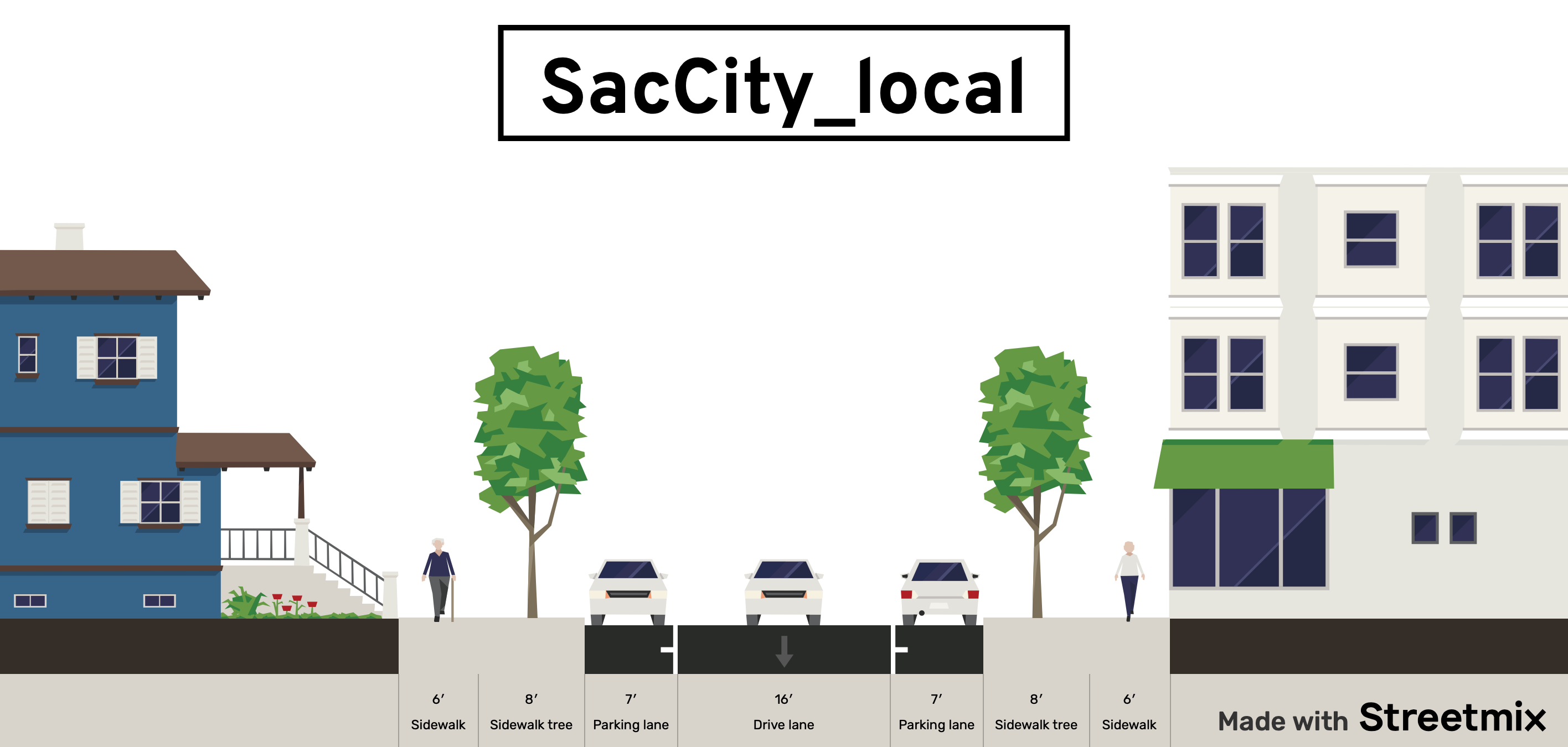
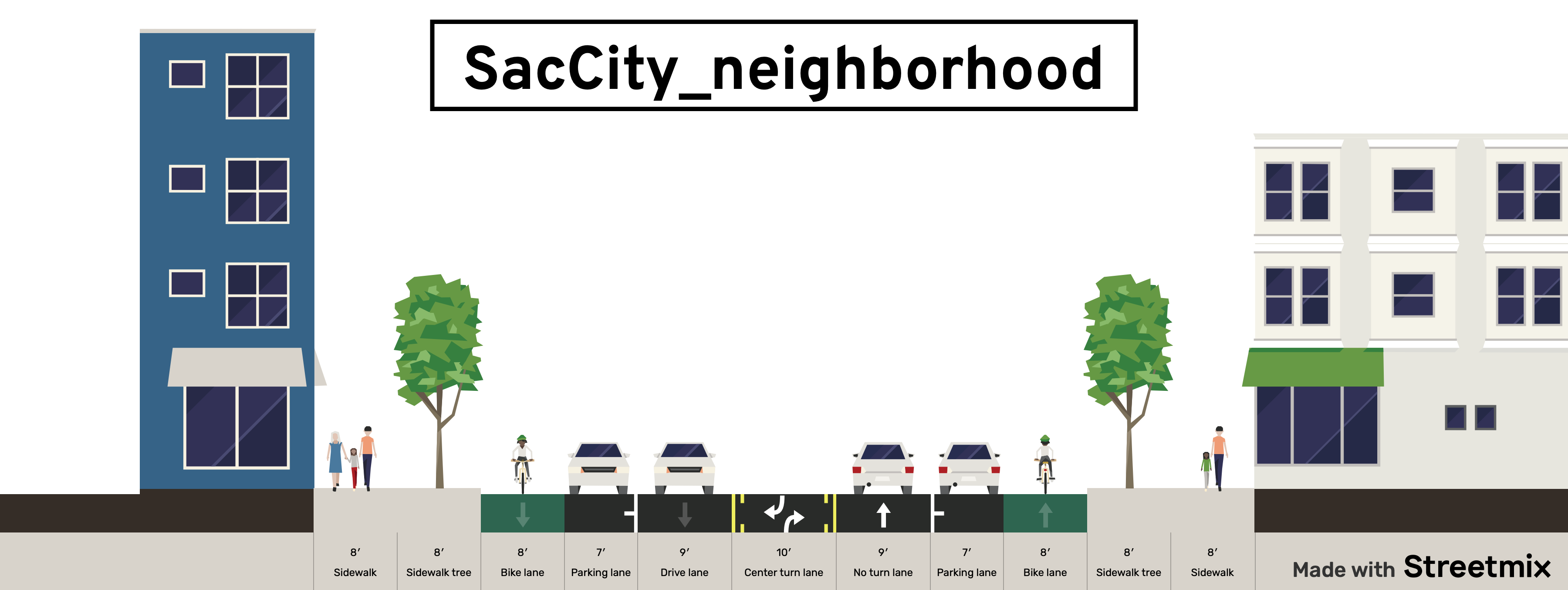
Street classification (see below for diagrams):
- local or yield: narrow lane (unmarked), parking, up to 20 mph; for local travel
- neighborhood: two lanes, regular bike lanes, up to 30 mph; for local and through travel
- corridor: two to four lanes, bus lanes, separated bikeways, up to 40 mph; for local and through travel
- traditional functional classification system (arterial, collector, local) will not be used; classification into residential, commercial, etc will not be used since all areas may be mixed use
- new or reconstructed streets will not be designed for more than two lanes per direction
Policies
- All one-way multiple lane streets should be considered for conversion to two-way streets
- One-way single lane streets will be considered for narrow right-of-ways widths or where right-of-way is needed for other purposes
- Streets which are repaved and re-striped (reallocated) but not reconstructed will include striping that increases safety and reduces speeds
- Reconstructed streets will be designed for the level of VMT (vehicle miles traveled) or ADT (average daily traffic) that is desired for safety, livability and economic vitality; the design or posted speed limit prior to reconstruction will not control in any way the new design
- Design for reconstructed streets will consider the reduction or consolidation of driveways, and particularly of driveways that are too close to intersections
- Driveway width for single family residences will be no more than 10 foot width; driveways for multi-family and commercial areas will be the minimum required by fire agency
- Center turn lanes will be used only where frequent turning movements into or out of driveways are expected and accepted; they will not be used to fill excess roadway width
- Speed humps or tables on a street generally indicates a failure to design for the desired speed, and will not be used on new or reconstructed streets, and only as a temporary solution on other streets
- When streets are re-striped after repaving, but are not reconstructed, the excess lane width will be devoted to other uses or marked off as invalid travel areas
- Designs will not include dedicated right hand turn lanes, and will not include multiple left hand turn lanes
- Rough pavement surfaces such as brick, cobblestone, or stamped concrete will be considered whenever reduced speeds are desired; however, crosswalks and bike facilities will be smooth
- Rolled curbs will not be used on new or reconstructed streets
- Streets which are repaved will implement, to the degree possible, the same design as reconstructed streets via right-of-way reallocation and striping
Design diagrams:
- NACTO-like diagrams which show the overall design of each street type
- One-lane, one-way streets
- Woonerfs (shared streets) without curbs and with design elements to ensure speeds of 10 mph or less
- Bioswales for management of storm water
The remaining post in this series will be about intersection of neighborhood streets, and corridor streets. Stay tuned!


The neighborhood street will be more bikeable with the same raised bikeway treatment as the corridor, and solves the issue of exposure when there are no parked cars. I would be very pleasant to ride along, and might make for more consistent and predictable intersection design, as well. This is beneficial for all road users.
When you get to the intersection design section, there is a new (oversized) intersection in UCD Med Center at 48th and X with some good elements. Very Dutch, except that you end up back in a bike gutter afterwards. I don’t know how the signals operate.
The maximum corridor speed should be 35 mph; I assume you’d propose reconstructing Freeport or Stockton Boulevards (at least the northern sections) to this standard, and the limits there are currently 35, which is more than adequate for such environments.
I think in a previous post you wrote that, if a street was 2 lanes, and there was high frequency bus service, there must be a dedicated bus lane. I’m pretty sure that nearly every road of the corridor class has (or should have) such bus service, so maybe it’s better to just call out that a corridor has exactly 2 traffic lanes (with single left turn pockets), and potentially bus/transit lanes. I’m thinking, again, of streets like Stockton Blvd, Freeport Blvd, Northgate–even El Camino and Fruitridge away from the freeway approaches.
Totally agree on classifying everything wider/faster as “road”… or “expressway”, and separating bike and foot access as fully as possible from car traffic in such cases.
LikeLike
These are preliminary classifications that I like, but I’m sure my perspective will evolve, with time and feedback.
I tend to be a little more tolerant of speed than some, so I’d accept regular bike lanes up to 30. The problem I have with parking protected is that when the cars aren’t there, they aren’t protected, having only pavement crosshatch or vertical delineators, which are visual but not physical protection. And why I’m leaning more towards sidewalk level, which at least has curb protection.
Again, I’m focused on new/reconstructed, and still need to think more about reallocation and mitigation.
Not all corridors presently need dedicated bus lanes, as there are not the operations funds to support that density of service at this time, but it is critical that we don’t foreclose that through design.
I see Stockton as corridor but Freeport as neighborhood.
I will get to reading your posts (I’ve only been skimming) and looking at your examples of existing.
LikeLike
I guess Freeport has the light rail on one side and the freeway on the other, so I concede that it might be better to do a “neighborhood” treatment with a parking/bus bay lane (with boarding islands).
Regarding the point about removing driveways when possible, I strongly agree especially regarding driveways serving larger parking areas. This is true for both neighborhood streets and corridors. The traffic at a parking lot entrance can easily exceed that of a local street, with none of the intersection design. When I was looking at the Freeport plan and walking the street, I thought the worst part of the experience was the number of driveways you needed to cross. It’s an absolute deal breaker for low-stress cycling.
I came across these streets in the Netherlands which use narrow frontage roads with diagonal or parallel parking along them to provide local access. The bike path runs along the main street, while the sidewalk runs in front of the buildings. We can imagine that existing off-street parking lots could be served the same way. These are both something like “corridors”, though the traffic lane count is flexible. But look how short the crossing distances are when there are no parking and bike lanes, along with a median!
Gedempte Where
Waterlandlaan
LikeLike
[…] the SacCity intersections of local streets post, addressing intersections of larger streets. See SacCity street classification for detail on types of streets (local, neighborhood, […]
LikeLike
[…] that traditional traffic engineer focus on maximizing motor vehicle volume and speed. See SacCity street classification for more […]
LikeLike