Obviously there are different kinds of streets that serve different purposes. One of the simplest is street-stroad-road, the Strong Town concept that there should be only streets and roads, and the combination is a failure which they have labeled stroads. But a two-category classification is probably too simple.
The existing City of Sacramento Street Design Standards (2009) offers the table below.
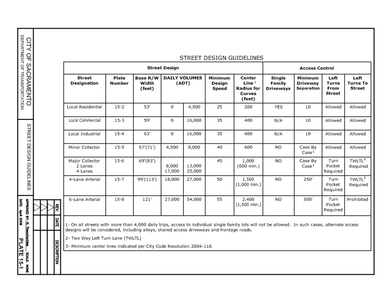

Both of these classification systems were developed for and reflect motor vehicle throughput. The more vehicles and the more speed, the higher the classification. This is the wrong way to go about designing roadways. It assumes that the primary purpose of roadways is to move motor vehicles. We know that is not true, or at least shouldn’t be true.
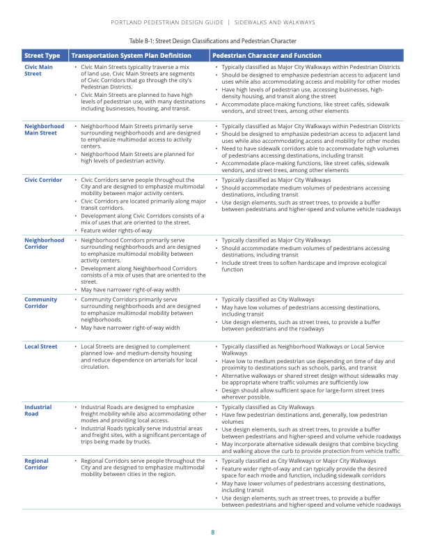
Portland (PBOT) uses a street classification system with eleven street designs, which are supplemented by five pedestrian classifications, four bicycle classifications, six transit classifications, and nine freight classifications. Yow! An advantage of the Portland system is that it includes details about each category, including land use, lanes, width, function, curb zone, separation, design elements, design treatment, and utilities. The Pedestrian Design Guide, simplifies down to eight classifications, shown below (pdf).
First, I believe that it is critically important that the city drop use of functional classification from its updated street design standards. Not only does the public not understand this classification system, it leads to roadways dominated by motor vehicles. That is not what we want in the city.
I don’t yet know what street classification system might work well for Sacramento, but I am certainly thinking about it, and researching for it. Probably not more than five classifications, for simplicity of understanding by the public, and so that the number of different designs are limited.
I have written about a three-classification system based on speed. That is a useful concept, and easy to understand, but it does not illuminate the surrounding land use nor the feeling and livability of the street. So rather than being a classification, speed limits (design and posted) should be set for each street classification, after the classification description is developed.

It has more classifications than you prefer, but how about something like:
Suburban local street: low density housing. Speed <20mph. May be narrow, shared or filtered.
Suburban main street: neighborhood commercial, elementary schools, low rise mixed use.
Suburban corridor: larger scale mixed use, middle and high schools, supports high quality bus service
Shopping local: within shopping centers/areas. Maybe unneeded?
Urban local: quiet but dense
Urban corridor: busy areas, transit corridors, entertainment venues
Industrial local: moves trucks
…
Suburban expressway: a road instead of a stroad. 4 lanes plus turn. Strictly limited business access. No sidewalk or on street bike lanes. Parallel MUP and or bike road required. Best feasible walk bike treatment at intersections.
I feel like these cover most of the development types I can think of, based on your suggestion to think from the (desired) development form to the appropriate street form, instead of just designing to traffic load.
LikeLike
Thank you for contributing so many ideas. I am not in favor of using terms urban and suburban, because I believe that all land use will evolve to be mixed, a gradation rather than a different type of land use. The 2040 General Plan will reduce the number of zoning categories, and removed R1 which is now essentially illegal, but it won’t eliminate zoning. I am set on the term ‘local streets’ that would be designed and posted (if posting was even needed) at 20 mph or less. Still thinking about wider/faster streets and what terms to use.
LikeLike
Agree that “suburban” may have the wrong connotation. I was trying to draw a distinction between single family/multiplex/low-rise apartment street scape, and one with more density. The traffic width would probably be the same (your <18' for instance), but maybe you just trade off between sidewalk and "planting strip" width (and other furnishings) depending on pedestrian volume. This design could potentially encompass the "commercial" version also.
Do you think there's a case to be made for a local/shared street smaller than the narrow 2 lane you propose?
After posting my reply and re looking at the existing Sacramento guidelines, I don't think the categories there are far off–they are just too auto-centric: too wide and too fast. The minor collector is like the "main street" and the major collector is like the "corridor".
Then there are the troublesome arterials…
LikeLike
Absolutely there is a place for shared streets. It took quite a while to produce the local streets graphic, and will take me quite a while to produce others! I agree that everything the city has done to this point is too wide and too fast.
I don’t think we need any new arterial roadways, anywhere. A good grid system with new or reconstructed streets to handle a lower volume at safer speeds is what we need. Arterials are not economically productive, nor in any other sense useful. I call them traffic sewers. But there does need to be information and designs to mitigate arterials, because they will be with us for decades.
Yes, the local street design could handle more commercial/retail activity, but I think there should be bike facilities to handle the additional traffic generated by that. After all, isn’t that how most people would be getting to commercial/retail outside their immediate neighborhood? Again, I haven’t settled on designs for wider/faster streets, but I think it is reasonable to have a higher speed limit on streets which have significant commercial/retail. Or not. Still thinking.
Your questions and ideas are helping me think about street design, so thank you. Keep it up!
LikeLike
Oh, I meant to add that perhaps “bike roads” and “multiuse paths” should be considered for addition, to develop design standards for then and to keep them in mind to planners and engineers.
LikeLike
Certainly there is a need for the bigger neighborhood “main” street, and I agree that those would be the preferred cycle routes. Traffic speeds of 25 or possibly 30 mph would make sense, depending on the design and location. I’m not sure if there should be a small version with no turn lane/pocket, and a larger one with a median/turn lane/turn pockets. Both would need excellent cycle facilities and enough friction from curbs and parking to keep car speeds low.
I kind of run out of ideas once a street (historically) needs to be wider. When biking and walking, and often when driving, they are never pleasant.
It is interesting to look at the Netherlands and see how few 4 lane roads there are. And most of them are “roads” that do not provide property access, with bike/Walker paths buffered from the road.
LikeLike
[…] for the revision of the street design standards. I have written about street classification before: how to classify streets?; NACTO yield street; NACTO neighborhood main street; and NACTO neighborhood […]
LikeLike