NACTO (National Association of City Transportation Officials) is the lead organization for progressive transportation cities. It is in strong contrast to regressive organizations such as League of California Cities which exist primarily to serve suburban areas. Of course part of the difference is the size of the cities, as NACTO tends to include large cities, while League of California Cites tends to include small cities, but it is really a difference in attitude about what cities are for. NACTO cities are cities for people, League cities are cities for cars and businesses. Take a look at CalCities Partners to see who the League likes. Unfortunately, City of Sacramento is a member. But on the plus side, Sacramento is also a member of NACTO.
In upcoming posts about Street Design Standards, I will be using NACTO materials often, primarily from the Urban Street Design Guide, but from the Transit Streets Design Guide and Urban Bikeways Design Guide as well.
I believe that the Street Design Standards should include both overviews of different kinds of streets, to provide city staff, city council, and most importantly, the public, a clear picture of what a new or reconstructed street will look like and feel like. Design details are also important, but design details without context just allow staff to build streets that follow the rules but neglect safety and livability.
So, first up, the overall design that NACTO calls a Yield Street. The portion of the street devoted to moving motor vehicles is less than most of the streets in Sacramento, but the portion devoted to street-related uses is more. The most prominent difference is that the travel part of the street is not two lanes, but a shared area (hence, the yield name) where drivers must negotiate to pass and adjust for variable widths as parking and other uses vary. This is easily a street for a 20 mph design and posted speed limit, as all local streets should be. Note also: wide planting strips with trees, perpendicular ADA ramps, high visibility crosswalks, curb extensions on most corners, small corner radii, pedestrian scaled lighting, and reduced but not eliminated parking. The diagram shows just residential uses, but the design can easily accommodate corner stores.

A diagram for Sacramento might look a bit different It could show a mix of housing types rather than single family only, and could show a corner store. But the concept is the same, that this is a street that serves people first, and motor vehicles to a lesser degree. Speeds are low and the street feels safe. Though this would not be a primary bicycle route, it would be safe for bicyclists because of the low speeds. It doesn’t need a bike lane. Sacramento central city and some other parts of the city already benefit from a lower driveway density than many cities, and a diagram could reflect that. In the future, Sacramento will not have exclusively single family residential zoning, so neighborhoods with these kinds of local streets will gradually evolve to include a better mix of housing types and small retail that fits into the neighborhood.
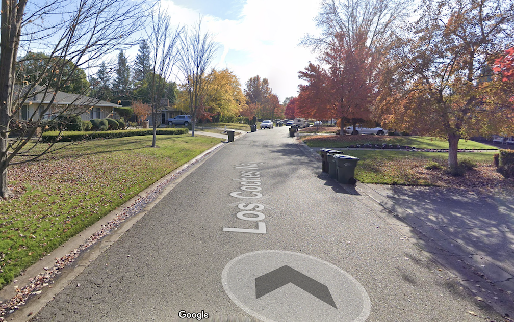
The photo below is of Los Caches Way in the Arden area of unincorporated Sacramento County, not in the city. This is an upscale neighborhood. Parking is allowed along the street, but when the street is occupied by parked cars, drivers must negotiate a width that is too small to pass without yielding. Of course a better street would have sidewalks along at least one side, but I think it is worthwhile showing a street that rich people like, and more or less fits the NACTO Yield Street model. Everyone can have yield streets, not just rich people.

Seems like a good fit for many of our too wide streets. Have you seen the Project for Public Spaces one in NY – https://www.pps.org/article/new-yorks-most-exciting-new-public-space-is-a-street-in-queens Similar street but also adding street furniture and the like to make it more active. I think the one in NY is one way too.
LikeLike
That’s a great article, thank you. We had three blocks of streets somewhat like 34th during the pandemic, but the city reverted to its cars and parking first priority by removing them. These kinds of street treatments would have to be done on a more local and neighborhood involved process. In using the NACTO street designs, or similar adapted to Sacramento, we can have a few street designs that fit most streets, without having to do as much detailed adaptation.
LikeLike
[…] on NACTO street types, the neighborhood main street, from the NACTO Urban Streets Design Guide. See NACTO yield street for the first, and some background on […]
LikeLike
[…] design standards. I have written about street classification before: how to classify streets?; NACTO yield street; NACTO neighborhood main street; and NACTO neighborhood […]
LikeLike