And now for the third analysis of high injury network intersections and the relationship to the Sacramento Vision Zero Top 5 Corridors. The dataset this time is all killed or severe injury collisions in Sacramento, for all modes of travel, for the period 2009-2017. Of the 1641 collisions in the city, 322 (20%) were at intersections defined by the intersection of arterial and/or collector streets. There is also a pdf map available.
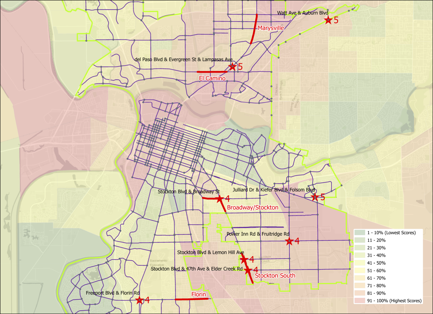
Of the eleven intersections with four or five collisions, three are on the Top 5 Corridors:
- Stockton Blvd & Broadway, 4 (on Stockton-Broadway corridor)
- Stockton Blvd & Lemon Hill Ave, 4 (on the Stockton South corridor)
- Stockton Blvd & 47th Ave & Elder Creek Rd, 4 (on the Stockton South corridor)
and eight are not:
- Watt Ave & Auburn Blvd, 5
- Del Paso Blvd & Evergreen St & Lampasas Ave, 5
- Julliard Dr & Kiefer Blvd & Folsom Blvd, 5
- Power Inn Rd & Fruitridge Rd, 4
- Freeport Blvd & Florin Rd, 4
- Center Pkwy & Cosumnes River Blvd, 4 (not on map)
- Bruceville Rd & Cosumnes River Blvd, 4 (not on map)
- Franklin Blvd & Mack Rd, 4 (not on map)
The three last intersections are not on the map because I wanted to maintain the same scale as used for the previous maps, but they would be off the south edge of the map. Note that the number of collisions at these intersections is not directly comparable to the bicycle collisions map I created because I used a different dataset, degree of injury and span of years. I may go back and update the bicycle map to be consistent, but it is probably more worthwhile to look at some of these intersections in more detail.

[…] about the intersections maps and what they show (Sac Vision Zero top intersections all modes, Sac Vision Zero top ped intersections, Sac Vision Zero Top 5 Corridors and […]
LikeLike
[…] Zero high injury intersections in the City of Sacramento: Sac Vision Zero new intersections map, Sac Vision Zero top intersections all modes, Sac Vision Zero top ped intersections, Sac Vision Zero Top 5 Corridors and top intersections, […]
LikeLike
[…] The City of Sacramento has 11 red light camera locations: Red Light Running Program. Of these, some are at high-injury intersections, but most are not. These locations are cross-referenced with high injury intersections shown in the post Sac Vision Zero new intersections map. […]
LikeLike