Fruitridge Road Safety and Mobility Plan observations

I posted on the Fruitridge Road Safety and Mobility Plan (2026-02-21), which was before the first community meeting on March 4, which I attended. There were a number of display boards with details that are not necessarily in other documents, but I did not capture those. A second workshop, on July 6, which presented updated concepts based on the first workshop and other outreach, I was not able to attend. The project website has a number of documents of interest, including all those that I reference below. Note that there is another city project, Fruitridge Road Improvement Project, east from Stockton Blvd to Power Inn Road, that is separate from this project.

The public outreach for Phase 2 is complete, and there is no formal process at this time for public input. However, you have the right as a citizen to email the project lead, Virginia Morgan, VMorgan@cityofsacramento.org.

Overall

The map below shows the corridor, and related transportation projects.

map of Fruitridge Road Safety and Mobility Project

The project extends from Riverside Blvd to on the west to Stockton Blvd on the east. The roadway from Riverside to South Land Park Drive is named Seamas Avenue, which is important if you are looking at details in the documents, but I’ll refer to the entire corridor as Fruitridge Road. The section from Riverside to Freeport Blvd is four lanes, but with fairly low traffic volumes and speeds. The posted speed limit is 35 mph. From Freeport to 24th Street, volume and speeds are higher, and the roadway has frontage roads on south and then north side. The posted speed limit is 40 mph. From 24th all the way to Stockton Blvd, the corridor is mostly commercial, with some residential here and there. Volume and speed are again higher. The posted speed limit is 40 mph, but observed speeds are much higher, particularly in the vicinity of the Hwy 99 interchange, where drivers reach highway speeds at the onramps, and continue highway speeds coming off the off-ramps. The section from east edge of the freeway interchange to Stockton Blvd is mostly within Sacramento County, not the city. This section has paint-only bike lanes, which apparently were added in 2024.

Traffic Violence

The corridor map below shows collisions. As is no surprise, they are concentrated at major intersections, but also occur in between, most likely at side streets or driveways. Few collisions are shown for the Hwy 99 onramps and off-ramps, possibly because this data was not included. Though the interchange is within the city, it is completely controlled by Caltrans and collisions would be reported by CHP, not the city. When I asked the consultants why the collision density was so much higher in the county section than the city section, they speculated that it was because there was so much more commercial activity and driveways in that section.

Sidewalks

With few exceptions, sidewalks throughout the corridor are five feet wide. Though there are problems here and there, including utility poles in the sidewalk, and a gap east of the Del Rio Trail, they are overall in decent condition. The lack of trees along this corridor does reduce sidewalk heaving. Driveways are frequent, particularly between Franklin Blvd and Stockton, including the county section. More than half of the driveways have a steep cross-slope in the sidewalk, not meeting current PROWAG/ADA requirements. Some, mostly within the county section, have been fixed with the ramp down, ramp up solution, which is legal but not optimal. Many of the unmodified driveways present barriers to travel with mobility devices, and discomfort for all walkers. All sidewalks and driveways within the project area should be upgraded to PROWAG compliance. The best way of doing so it to install a sidewalk buffer (which the city calls planting strips) so that the driveway slope in within the buffer, not within the sidewalk.

photo of side-sloped sidewalk at driveway, not PROWAG/ADA compliant (and overly wide driveway)
side-sloped sidewalk at driveway, not PROWAG/ADA compliant (and overly wide driveway)

Sidewalks should be a minimum of six feet wide, with additional width where higher walker use justifies it. Initially, the project proposed to leave almost all of the sidewalks untouched, only widening them where there are bus stops. The new Alternative 2 – Enhanced Improvements, considers but does not promise widening sidewalks along the corridor. More on this below.

I keep harping on the city’s user prioritization diagram, from the 2024 General Plan, but it is worth remembering for every single project. Not only does it show pedestrians (walkers and rollers) as the top priority, it shows a tree with the walker. The tree is essential for creating a welcoming and safe environment for people walking. But trees are the one feature most neglected in transportation planning and infrastructure. Every city project has resulted in fewer trees than were promised, despite trees being one of the top requests by the public.
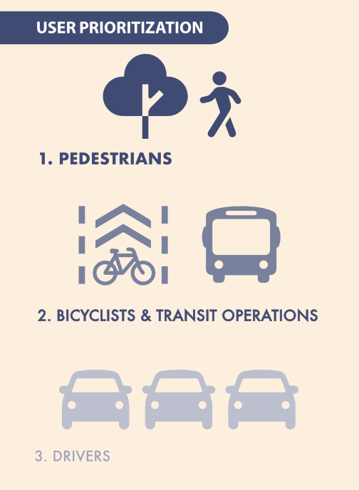
graphic of User Prioritization from City of Sacramento 2040 General Plan

Roadway re-allocation

The project plan focuses on lane number reductions and lane width reduction, and the question of whether the eastern Segment 2 from 24th Street to Stockton Blvd will be two lanes (three with center turn lane) or four lanes. I don’t think this is the most important issue, except as re-allocation allows for wider sidewalks and sidewalk buffers. I find that Alternative 2, illustrated below, is the only acceptable design of the three presented. The diagram shows a section without driveways, but frequent, poorly designed driveways are characteristic of much of Segment 2. Only this alternative allows continuous level sidewalks, with driveway ramps in the sidewalk buffer. Though at this stage of planning, the width of the widened sidewalks and new sidewalk buffers is not specified. I believe that sidewalks should be a minimum of six feet, and wider where walkers and rollers are more frequent. Bus stops should have at least eight feet of sidewalk, and most bus stops should have bus shelters and other amenities that are not within that eight feet. Buffers should be a minimum of eight feet, to allow for tree health and growth without sidewalk buckling. The city has been using buffers of 4 to 6 feet on many projects, which is too narrow.

The Phase 2 Design Alternatives document, which I assume must have been the display boards at Workshop 2, does have widths shown for the various segments, but unfortunately, these diagrams do not exactly match the diagrams in the presentation. For example, the presentation Alternative 2, below, indicates widened sidewalks, but the design alternatives document continues to show the existing five foot sidewalks.

Sidewalks should also be continuous across intersections with local streets. These raised crosswalk/sidewalks clearly communicate to drivers that they need to slow, and look, when crossing a sidewalk, that they are guess in the walker space, not the preeminent user. There may be intersections with collector and arterial roadways, and other signalized intersections, where continuous sidewalks/raised crosswalk are appropriate.

Bicycle facilities

Alternative 1 shows paint-only Class 2 bicycle lanes. These are unacceptable on roadways over 30 mph, and with the current speed limits at 35 mph and 40 mph, they are not safe. Unless posted and design speed limits are reduced to 30 mph on the corridor, bicycle facilities must be protected with at a minimum, wide buffers with vertical delimiters, and preferably and safer, concrete medians and curbs. Without width specification, it is unknown whether these facilities will accommodate modern bicycles and riders. But as with all bicycle facilities, the more important issue is how bicycles are accommodated at intersections. The city has not done well with this issue.

Intersections

Intersections are where most collisions occur, and the locations where walkers and bicyclists are most at risk, and most discouraged, but the documents available to date don’t show intersection modifications.

There are two intersection in the corridor that must be significantly modified to make them safe for all users. At Fruitridge Road and Freeport Blvd, the intersection flares to have five westbound lanes, with two dedicated left turn lanes, two through lanes, and one dedicated right turn lane. A crossing distance of 113 feet! Eastbound, four lanes, with one dedicated left turn lane, two through lanes, and one dedicated right turn lane. A crossing distance of 100 feet! There are problems with the design of Freeport Blvd as well.

overview of Fruitridge Rd & Freeport Blvd flared intersection
Fruitridge Rd & Freeport Blvd flared intersection

The intersection of Fruitridge and 24th Street is acceptable, though it could certainly be improved.

The intersection of Fruitridge and Franklin Blvd is unacceptable, with a similar flared design. The free right turn slip lanes from Franklin to Fruitridge are a clear and present danger to all users of the roadway, particularly walkers and bicyclists. These should have been removed as part of the Franklin Blvd Complete Streets project. And they should be removed citywide.
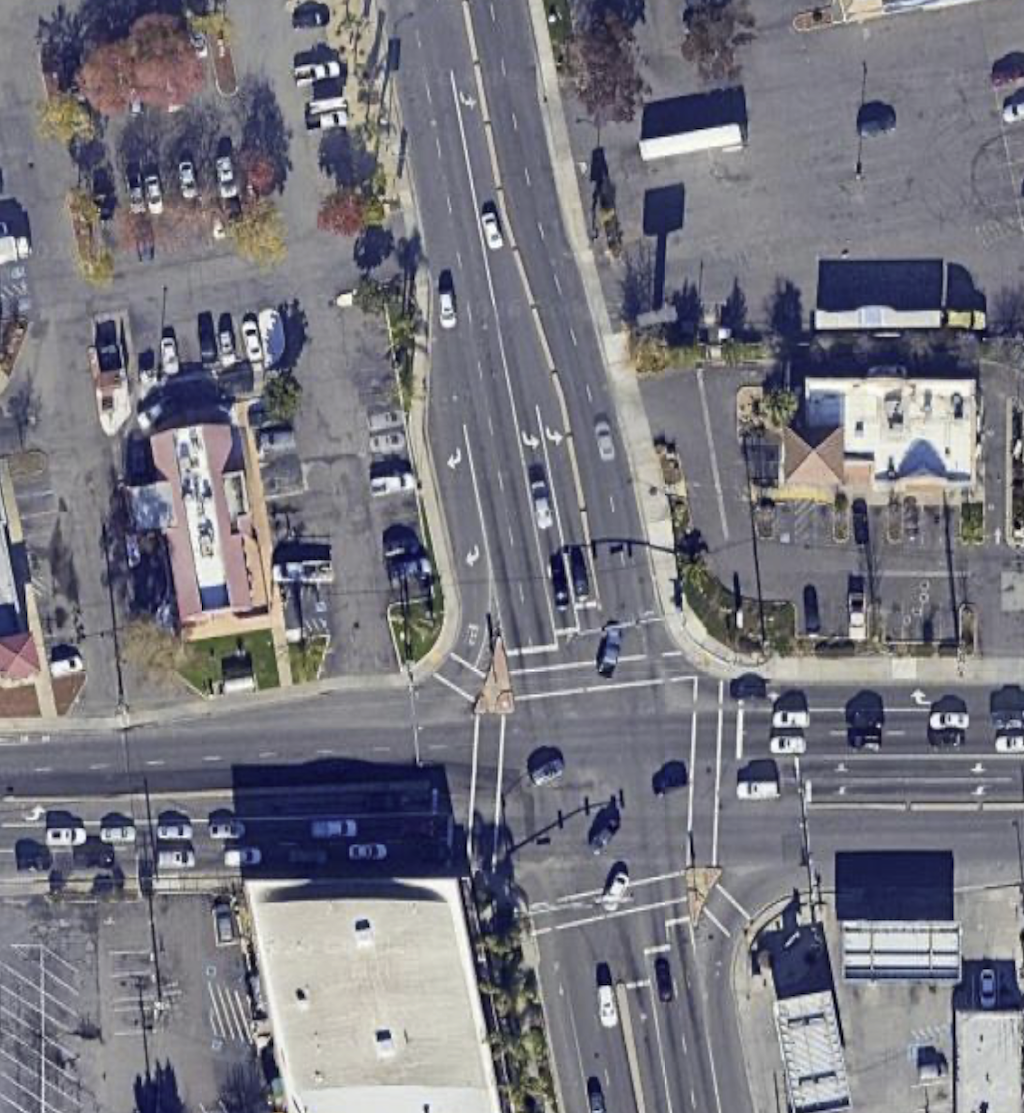
overview of Fruitridge Rd & Franklin Blvd flared intersection
Fruitridge Rd & Franklin Blvd flared intersection

The intersection of Fruitridge Rd and Stockton Blvd is the third problematic intersection, though it isn’t clear to me whether changes will be part of this project, or the future Stockton Blvd Stockton Transportation Enhancement Project. On Fruitridge, it is not as bad as the two preceding intersections, but the intersection is a vast area of pavement, unfriendly and unsafe for walkers and bicyclists.

These flared intersections create large number of conflict points for motor vehicles, and lengthen crossing distances for walkers to unacceptably long distances. Long crossing distances also slow signal cycles due to the longer pedestrian crossing time, frustrating drivers as well. They also encourage drivers to jockey for position at intersections, and accelerate hard to get ahead of others. Though not a common behavior, belligerent drivers also use turn lanes as bypasses for slow traffic in front of them, creating a high level of danger for everyone. The city has, in the past, installed these flared intersections to create stacking space for motor vehicles at signals, but shortening signal cycles can have the same beneficial impact.

I believe intersections should never have dedicated right turn lanes, and particularly, not ones leading to free right turn slip lanes. Right turning drivers can wait their turn with everyone else. Intersections should only have one dedicated left turn lane. Two or more turn lanes lead to motor vehicle conflict on turns, higher speed turns, and inattention by drivers to people in the crosswalk and bicyclists. Whether there are one or two through lanes (never three or more), depends upon the intended design use of the road. Not on existing traffic counts, but on intended use.

Hwy 99

The worst ‘intersection’ of all is the Fruitridge Road & Hwy 99 interchange. This interchange features three high speed onramps from Fruitridge Road to Hwy 99, and three high speed off-ramps onto Fruitridge Road. It is not a true cloverleaf interchange, which would have four of each, but it is bad enough.

On eastbound Fruitridge, the south side, bicycle lanes are dropped, and so are sidewalks. There are ‘no pedestrian’ signs approaching from the west and east. There are no marked crosswalks or pedestrian warning signs or ramps over the two onramps and one off-ramp. The sidewalk on that side is basically an isolated fake. I watched these ramps for some while. Drivers were entering the onramp to Hwy 99 southbound at highway speeds, far over the posted 40 mph speed limit. The off-ramp on northbound onramp were not as bad because they lead to fairly tight turns, and presumably most drivers know that excessive speeds will cause roadway departures.

On westbound Fruitridge, the north side, bicycle lanes are dropped, but there is sort of a sidewalk. There are sidewalk ramps to unmarked crossings of the one onramp and two off-ramps. There are even pedestrian crossing signs at each, and the west off-ramp, even added yield signs, though those may be for merging to Fruitridge, and not for the crosswalk. I watched the west off-ramp for a while. Every driver was exiting at highway speeds, though the posted speed limit is 40 mph.

I believe that all freeway interchanges should have right-angle entry and exits from surface streets, which cause drivers to stop, or at least greatly slow. If a walker or bicyclist got hit at such a ramp, it would be a low speed collision, and probably survivable. For the high speed ramps of this interchange, a collision with walker or bicyclist would almost certainly be fatal. When a city or county want to redesign an interchange to be safe, Caltrans response is almost always: ‘we’ll work with you on the design, but you are going to pay for the infrastructure, 100%’. Caltrans knows that its interchanges are deadly, but has no interest in fixing them. Cities and counties can rarely afford to do so. As for the lack of mapped collisions (see diagram above), I believe that collisions that happen at the exit of the off-ramps and entry of the onramps are considered to be on a state highway, under the jurisdiction of CHP and not Sacramento Police, so don’t show up in the city’s data.

overview of Fruitridge Rd & Hwy 99 interchange
Fruitridge Rd & Hwy 99 interchange

Bus stops

The designs use the phrase ‘Transit stops will need to be designed to accommodate bikeways’, but there are no diagrams or descriptions of what these would look like. This is a very important issue. The optimal bus stop is at a transit boarding island where the bus stops in the travel lane rather than pulling out of traffic. However, other options are possible and may be more compatible with the overall roadway design. An unanswered question.

The Upshot

Segment 1, from Riverside Blvd to Freeport Blvd, at perhaps at far as 24th Street, should be delayed. The traffic on this section is lower volume and lower speed than the rest of the corridor. Though it would be easier to re-allocate roadway width here, it does not have the same safety value. For Segment 2, to the east of 24th Street, and perhaps including the section from Freeport Blvd, the nature of the roadway, driver behavior, conflict points, and adjacent land uses changes completely. This is where the real problem is, and should be the focus of the project.

Hazardous intersections, particularly at Freeport and Franklin, must be fixed in this project, and these intersections are more important than fixing the corridor, because intersections are where the most conflicts occur, and therefore the most collisions. Even if the city fixed only those two intersections, the project would be progress.

Sidewalks for walkers and rollers are the most important aspect of any re-allocation project, of course more important than motor vehicle throughput, and even more important that bicyclists. Only Alternative 2 provide reasonable infrastructure for walkers and rollers. Sidewalks must be a minimum of six feet wide, even in low-use sections, and wider or much wider in heavily used sections. These sidewalk must be shaded by trees, which must be planted at about 30 foot intervals within sidewalk buffers (planting strips) of at least eight feet wide. Of course that means robust irrigation for trees and other plants during the period of establishment.

Wide concrete buffers, of the sort shown in Alternative 1 – Base Improvements, are a waste of concrete. Wide concrete buffers (8.5 feet!) are no more protective of bicyclists than 18 inch buffers, are a waste of project funds, and add to heat island effects of the roadway. The new Franklin Blvd Complete Streets unfortunately has a number of these. Don’t use them!

The city continuously refuses to reduce posted speed limits on reconstructed streets, with their faulty logic that speeds cannot be reduced without a speed study that shows lower 85th percentile speeds. But reconstructed, complete streets are essentially new streets, as though they had been constructed from scratch. The city can, and should, determine an optimal design and posted speed (which should be the same, not the over-engineered forgiving design speed of 10 mph or more over the posted speed). For this project, the design and posted speed should be 30 mph. Designing for slower traffic is even more important than reducing travel lane numbers.
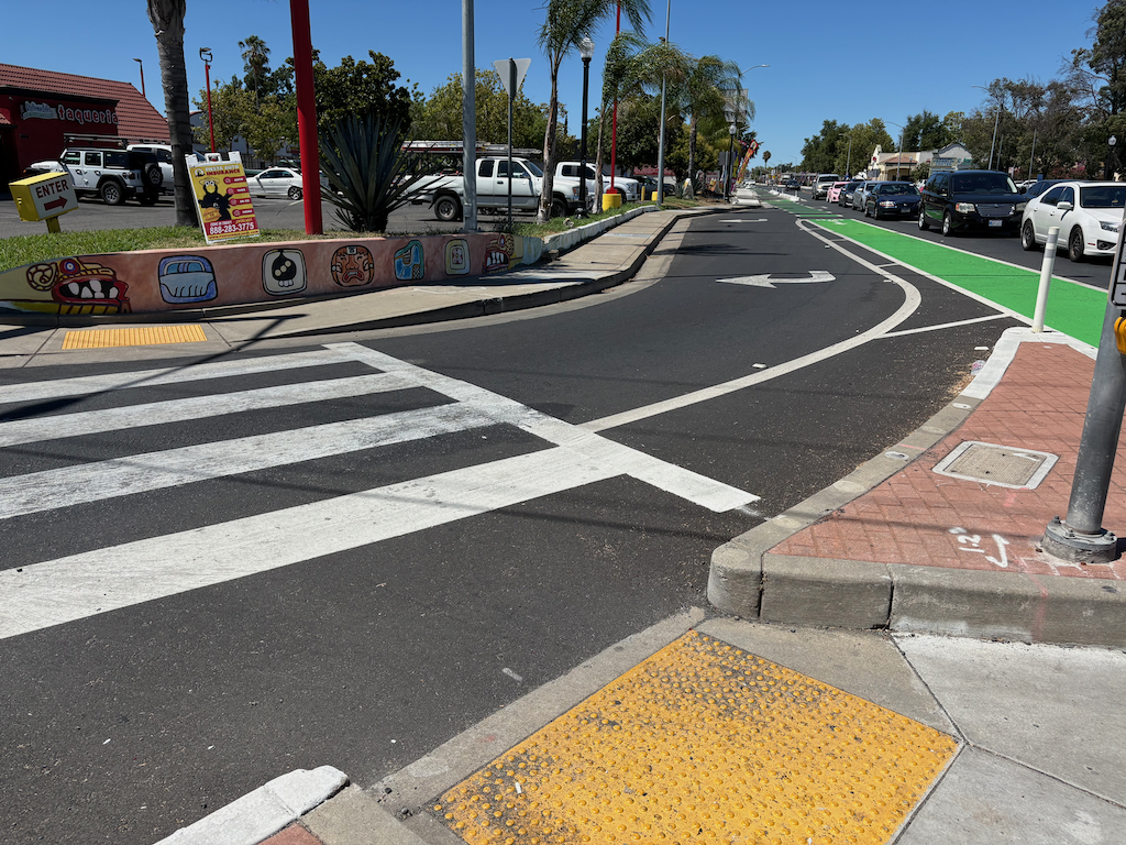
Franklin Blvd complete street

The Franklin Blvd complete streets project is… complete, with a ribbon cutting that occurred on Tuesday morning. This is a project that I have not been paying attention to, but I visited it to see what it is like. It spans Sutterville Road on the north to Fruitridge Road on the south, with the part south of Fruitridge to the county line not constructed. It is about 1.1 miles. Franklin Blvd runs from Broadway 25 miles to well south of Elk Grove, including the crossroads of Franklin, for which it was named. This section of Franklin is largely commercial, with small remnants of residential. The section north of here, to Broadway, is largely residential with some commercial, and is a much slower and calmer street.

The only publicly available document is the initial October 2019 plan. This plan included three similar but not same options. No information is available on what was actually built.

Though this project is complete, an analysis of what worked and what didn’t could help improve future complete streets projects that the city might undertake.

Bikeway: A separated bikeway was created along the corridor. It is protected by concrete curbs or medians for about half of its length, but some paint only sections remain, and the bikeway is interrupted by frequent driveways. Still, it was fairly well done. The initial diagrams show protected intersections with high quality bicycle facilities, but the actual construction at intersections is only slightly protected. OK.

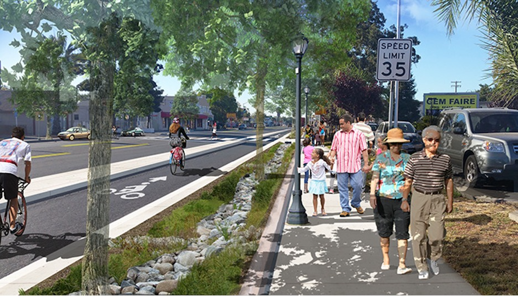
Trees: The initial plan includes this sentence: “Plant trees along street at approximately 30 feet apart, on-center, to provide shade and cooler temperatures.” If implemented, this would result in about 350 trees along the segment. There are 30. Failure. In addition, the trees are mostly in 5.5 foot wide sidewalk buffers (which the city calls planting strips), whereas trees need at least 8 feet to remain healthy and reduce sidewalk heaving. Failure.

The photo below is a mock-up from the initial plan. It is standard practice for city projects to show more trees than they intend to install. Gaslighting the public.

mock-up photo from initial complete streets plan

Other plantings: The initial plan indicated there would be bioswales throughout the project, but I saw only one small one. The plantings in sidewalk buffers are aesthetically pleasing, but not environmentally significant.

Sidewalks: Some sidewalks were upgraded to 6 feet, which is the modern minimum. Ramps were installed at intersections. Driveway crossings are a mix of acceptable and illegal, with cross-slopes in the sidewalk. Other sidewalks were left in their original condition of 4.5 to 5 feet. Falls short.

Sidewalk amenities: There are some trash cans provided by Franklin Blvd Business District. I did not see any other amenities. Weak.

Lighting: Pedestrian-scale lighting, with traditional poles, was installed along the length. The old motor-vehicle scale lighting was left in place. Though I did not visit the street at night, lighting looks to be a great improvement.

Driveways: There are a huge number of driveways in this section, largely due to the traditional development pattern of small business buildings on small parcels, with parking between the street and the building. This is an unfortunate pattern, but not something that can easily be fixed. Most driveways were replaced with a slope in the sidewalk buffer, or more commonly, dip down and back up, which is legal but not ideal. There are several driveways for long abandoned businesses and empty parcels, which should have been closed under the city’s driveway closure policy.

Safe crossings: There are existing signals at Sutterville Road/12th Avenue, 21st Avenue, Atlas Avenue (full pedestrian signal), 26th Avenue (to the west), and Fruitridge Road. At 18th Avenue, there is a new enhanced RRFB (Rectangular Rapid Flashing Beacon). There are RRFBs on a signal mast arm, in addition to at the side, perhaps safer than a standard RRFB, but given driver behavior in Sacramento, not safe. The distance from 26th Avenue to Fruitridge is just over a quarter mile, though there may not be a good location for a crossing in this stretch. The distance from Sutterville/12th Avenue to 18th Avenue is well over a quarter mile, which is an unacceptable distance between safe crossings.

Curb extensions: There was an opportunity to shorten crossing distances and slow drivers by providing curb extensions on the side streets. This was not done.

Bus: SacRT Route 67 runs on Franklin from Broadway to 21st Avenue. There is a pull-out bus stop just south of Sutterville/12th Avenue, which is a timepoint and may be appropriate, though pulling out of traffic, and back in, is poor practice. The other bus stops are in shared bus/bicycle areas, which is probably fine for a low frequency route (30 minutes). It occurs to me that it might be better to run service south on Franklin to Fruitridge Road, to consistently serve the commercial area. The route on Martin Luther King Jr Blvd does serve residential areas, but those are constrained by Hwy 99 to the west and a poor street grid, and the route misses Christian Brothers High School.

Franklin Blvd & Fruitridge Road intersection: This wide flared intersection is hazardous for all users, and nothing was done to improve it. Southbound, Franklin flares from one travel lane to two dedicated left turn lanes (unnecessary and unsafe), one uncontrolled dedicated right hand turn slip lane (highly dangerous for bicyclists and walkers), and one through lane. Everything that was good about the complete streets project gets tossed out the window at this intersection. I realize that it might have only been possible to fix the north leg of the intersection with this project, but no effort was made to do so. Complete failure.

photo of Franklin Blvd southbound at Fruitridge Rd, uncontrolled slip lane
Franklin Blvd southbound at Fruitridge Rd, uncontrolled slip lane
overhead of Franklin Blvd & Fruitridge Road intersection
overhead of Franklin Blvd & Fruitridge Road intersection (only one southbound lane now)

H Street Bikeway: intersections and bicycle signals

For other posts on the H Street Bikeway project, see category: H Street Bikeway. For the city webpage on the project, see H Street Bikeway to Sacramento Valley Station.

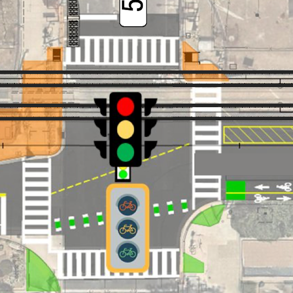
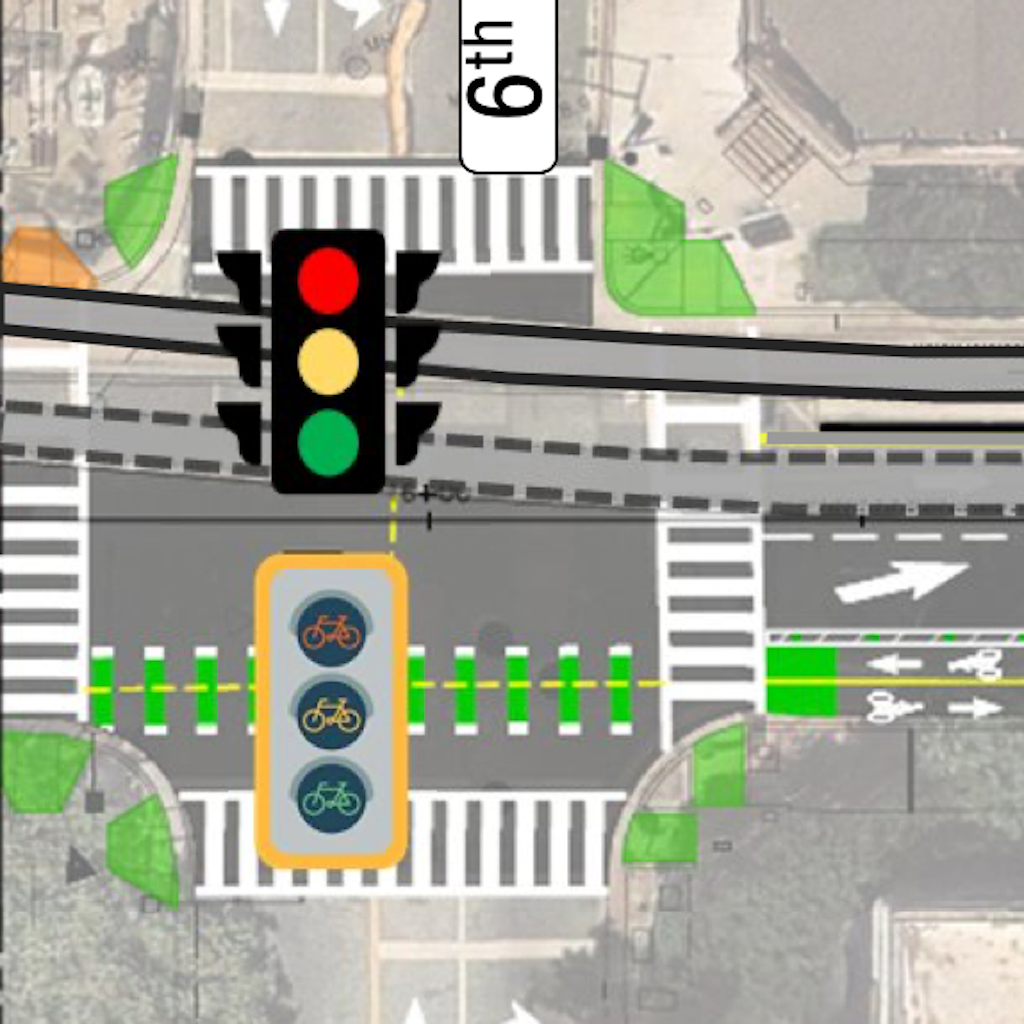
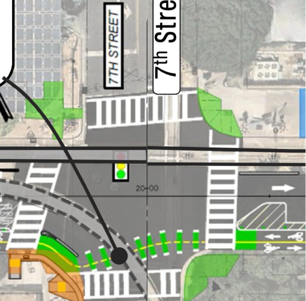
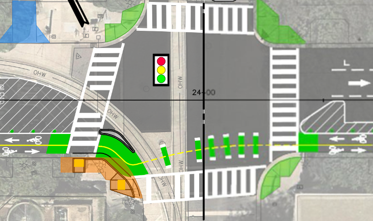
In designing a safe and welcoming two-way bikeway (cycletrack), design of intersections is critical. This post highlights the intersection. Both the staff report and presentation diagrams split the roadway at the intersections, obscuring the intersections themselves. The diagrams below show the intersections, and not the blocks in between the intersections. The diagrams are from the presentation, which offer more details about the intersections than the staff report. The images are rough because I glued together two parts which were not the same pixel resolution, but they provide a good idea of the intersections.

Key points:

  • bicycle signal faces are required at every intersection from 5th Street to 9th Street, but are indicated only at 5th Street and 6th Street
  • protecting bicyclists is particular critical at 7th Street and 9th Street to guard against right turning drivers heading southbound onto these one-way streets

5th Street: This intersection has a bicycle signal face for the two-way bikeway. The transition from the bikeway to Sacramento Valley Station looks awkward, and will be until the station itself is revised, which is also part of the TIRCP grant project.

image of H St Bikeway, 5th St intersection, proposed
H St Bikeway, 5th St intersection, proposed (from SacATC presentation)

6th Street: This intersection has a bicycle signal face for the two-way bikeway.

image of H St Bikeway, 6th St intersection, proposed
H St Bikeway, 6th St intersection, proposed (from SacATC presentation)

7th Street: This intersection does not have a bicycle signal face. It is particularly required here to protect bicyclist against drivers turning right onto 7th Street. No turn on red signing would not protect bicyclists on the two-way bikeway. 7th Street is one-way southbound south of H Street, and two-way north of H Street.

image of H St Bikeway, 7th St intersection, proposed
H St Bikeway, 7th St intersection, proposed (from SacATC presentation)

8th Street: This intersection does not have a bicycle signal face. 8th Street is one-way northbound.

image of H St Bikeway, 8th St intersection, proposed
H St Bikeway, 8th St intersection, proposed (from SacATC presentation)

9th Street: This intersection does not have a bicycle signal face. It is particularly required here to protect bicyclist against drivers turning right onto 9th Street. No turn on red signing would not protect bicyclists on the two-way bikeway. 9th Street is one-way southbound to the south of H Street, but two-way to the north of H Street.

image of H St Bikeway, 9th St intersection, proposed
H St Bikeway, 9th St intersection, proposed (from SacATC presentation)

SacCity Vision Zero Action Plan update: why intersections?

Other posts on the City of Sacramento Vision Zero Action Plan update are available at category: Vision Zero.

The 2018 Vision Zero Action Plan focused entirely on corridors. It did not identify high injury intersections, nor suggest actions at those intersections, unless they were also part of a high injury corridor.

The update does recognize that intersections should be addressed, but at least so far doesn’t focus on them. It should. Element 6 says “Continue developing designs and securing grant funding for the Top 10 priority corridors identified in the 2018 Action Plan, with a focus on roadway designs for reduced speeds and in Areas of Persistent Poverty” which is fairly specific. Element 7 says
“Complete 10 projects that separate severe vehicle-vehicle conflicts as well as vehicle-people or vehicle-bike conflicts at intersections” which is rather vague.

Why are intersections important? Because that is where most of the fatalities occur. Fatality locations are not, and should not, be the only criteria for focus. Serious injuries are also important, and the pattern of these is both more dense and different from fatalities. Actions that prevent fatalities or serious injuries are important.

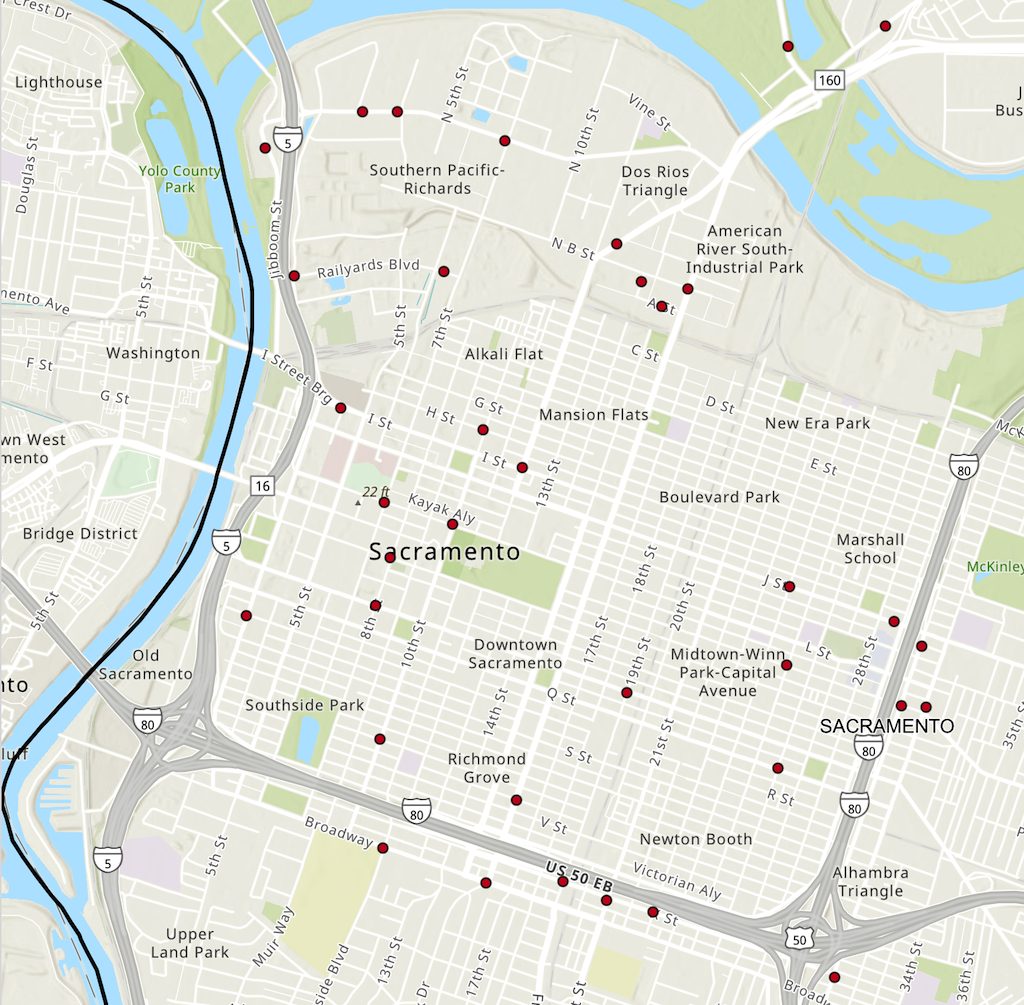
The map below, an except from the Vision Zero Crash Dashboard Interactive Map, shows only fatalities in the central city (American River to Broadway, Sacramento River to Alhambra). Of the 34 fatal crash locations shown, it appears that five are not at intersections, therefore 29 are at intersections.

This is a visual screen based on the map location of the crashes. The map shows primary road and secondary road for every crash, but does not show distance from the intersection. It would take an analysis of ever crash location to determine for certain whether it is at, near, or away from an intersection.

The only pattern that might be considered a corridor is X Street, the roadway just south of Hwy 50, known to be a high-speed traffic sewer.

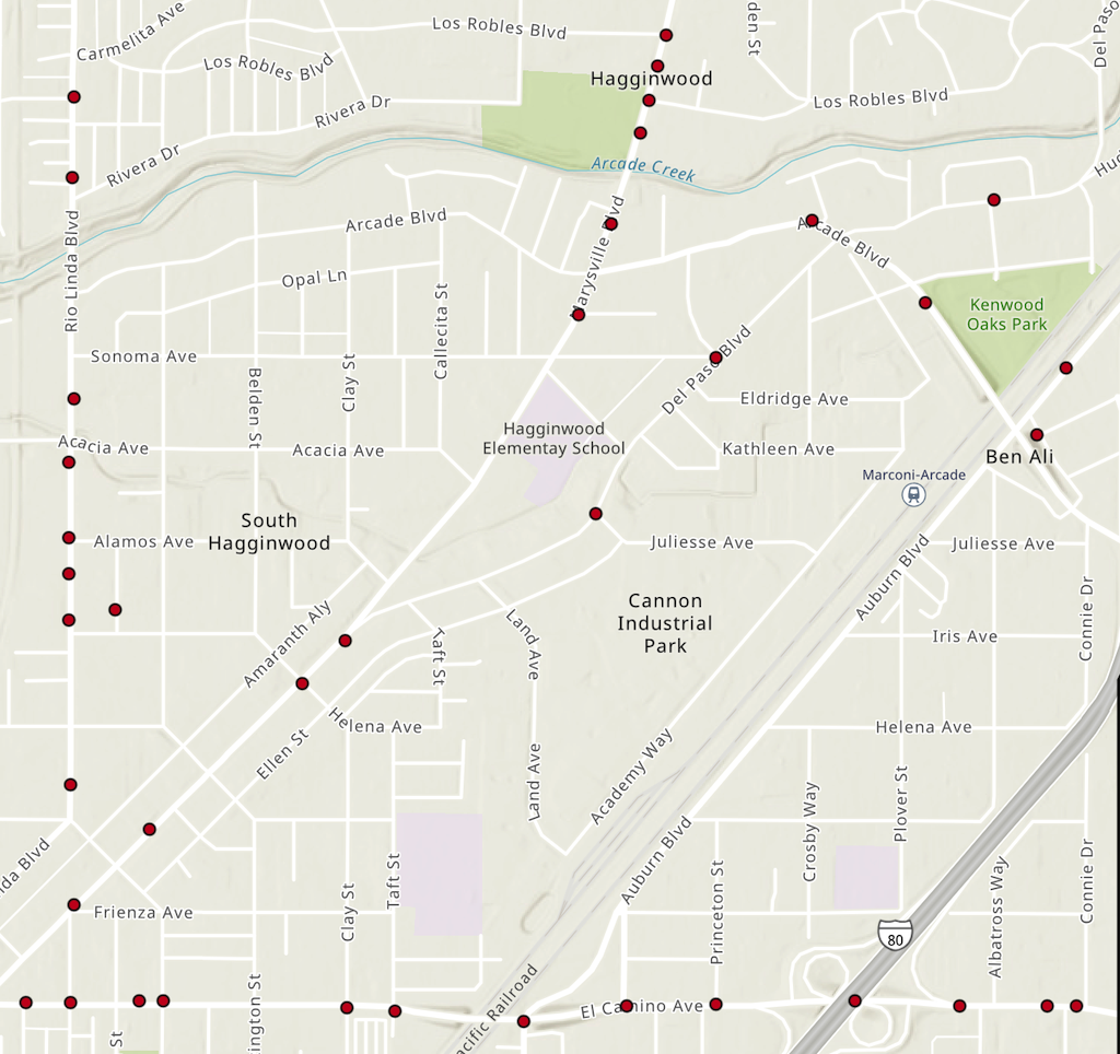
The next maps shows 39 crashes in an area of northeast Sacramento. Of the 39, it appears that 15 are not at intersections, therefore 24 are at or very near intersections.

This is a visual screen based on the map location of the crashes. The map shows primary road and secondary road for every crash, but does not show distance from the intersection. It would take an analysis of ever crash location to determine for certain whether it is at, near, or away from an intersection.

A corridor pattern is more evident on this map. Both El Camino Ave (at the bottom) and Marysville Blvd (middle north) have been identified as high injury corridors.

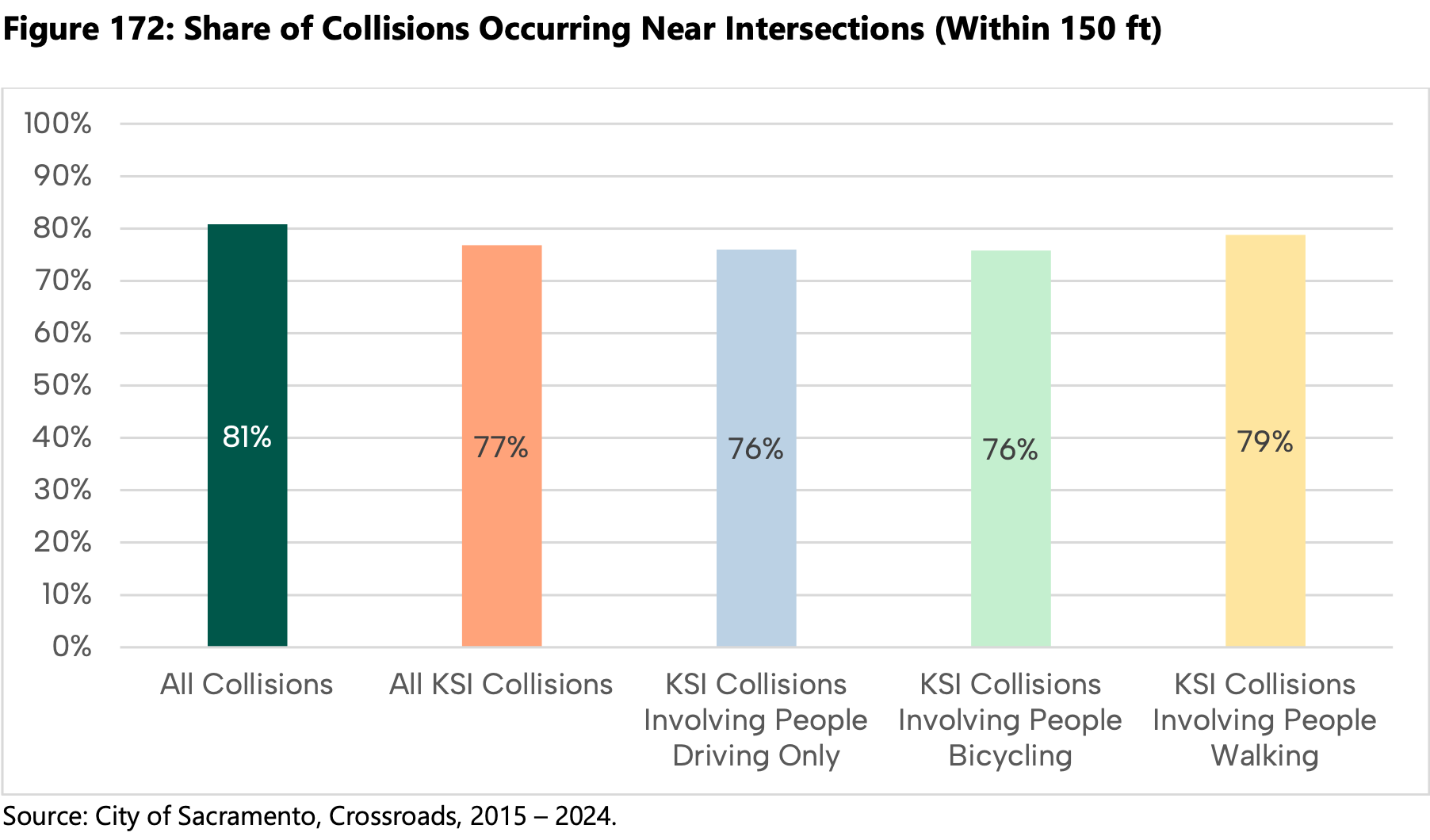
Confirming the intersection dominant pattern, the chart below is from the Collision Landscape Summary and Collision Profiles memo.

chart of collisions near intersections

The map below shows the Vision Zero Top 5 Corridors from the 2018 Action Plan.

map of Vision Zero Action Plan Top 5 corridors

Sac Vision Zero top intersections all modes

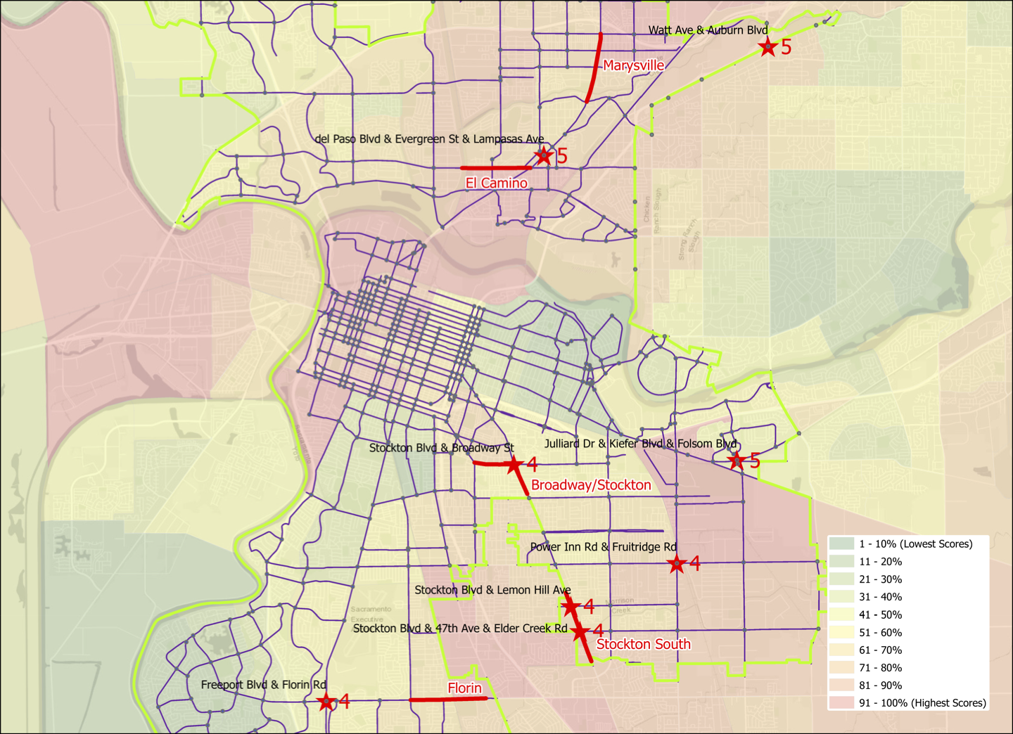
And now for the third analysis of high injury network intersections and the relationship to the Sacramento Vision Zero Top 5 Corridors. The dataset this time is all killed or severe injury collisions in Sacramento, for all modes of travel, for the period 2009-2017. Of the 1641 collisions in the city, 322 (20%) were at intersections defined by the intersection of arterial and/or collector streets. There is also a pdf map available.

Sacramento high injury network intersections and Vision Zero Top 5 Corridors

Of the eleven intersections with four or five collisions, three are on the Top 5 Corridors:

  • Stockton Blvd & Broadway, 4 (on Stockton-Broadway corridor)
  • Stockton Blvd & Lemon Hill Ave, 4 (on the Stockton South corridor)
  • Stockton Blvd & 47th Ave & Elder Creek Rd, 4 (on the Stockton South corridor)

and eight are not:

  • Watt Ave & Auburn Blvd, 5
  • Del Paso Blvd & Evergreen St & Lampasas Ave, 5
  • Julliard Dr & Kiefer Blvd & Folsom Blvd, 5
  • Power Inn Rd & Fruitridge Rd, 4
  • Freeport Blvd & Florin Rd, 4
  • Center Pkwy & Cosumnes River Blvd, 4 (not on map)
  • Bruceville Rd & Cosumnes River Blvd, 4 (not on map)
  • Franklin Blvd & Mack Rd, 4 (not on map)

The three last intersections are not on the map because I wanted to maintain the same scale as used for the previous maps, but they would be off the south edge of the map. Note that the number of collisions at these intersections is not directly comparable to the bicycle collisions map I created because I used a different dataset, degree of injury and span of years. I may go back and update the bicycle map to be consistent, but it is probably more worthwhile to look at some of these intersections in more detail.

Sac Vision Zero flaws

Edit: Added graphics for El Camino – Grove intersection and Broadway – Stockton intersection, excerpted from the Sacramento Vision Zero Top 5 Corridors document.

The Sacramento city council will be considering the new Sacramento Vision Zero Top 5 Corridors document at the council meeting on Tuesday, February 15. It is item 11 on the consent agenda, so will not be discussed unless a council member pulls it from the consent agenda.

I have taken a look at the document, though the one included with the with the agenda is a flat file, not searchable, and with low resolution graphics, making it hard to use. When a high resolution and searchable version becomes available, I’ll link to it.

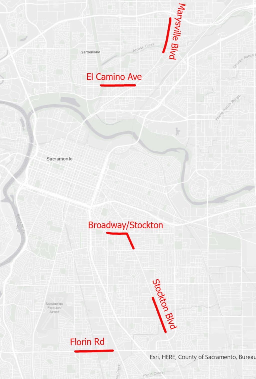
The document continues the pattern established in the 2018 Vision Zero Action Plan of focusing on corridors and not on intersections. The five segments presented as the top five are segments of El Camino Avenue, Marysville Road, Broadway/Stockton Blvd, Stockton Blvd south, and Florin Road. I believe that this exclusive focus on corridors is a mistake. Nearly all other vision zero communities have a dual focus on corridors and intersections, but Sacramento does not.

The Vision Zero Action Plan acknowledges on page 11 that 78% of collisions occur at intersections, but then seems to ignore this fact in pursuit of corridor projects. Of course if a corridor is done correctly, the intersections will be fixed as part of the project. The issue is that these corridor projects will cost millions of dollars and will require seeking state and federal grants to accomplish. The costs are El Camino $16,450,000, Marysville $12,850,000, Broadway/Stockton $8,750,000, Stockton South $9,500,000, and Florin $11,900,000. And these are only for the most important fixes; less important or more expensive fixes are somewhere off in the distant future. But a focus on the high injury intersections within the corridor could yield significant safety benefit at much lower cost, perhaps within the range of general fund expenditures.

This focus on corridors leads to some flaws in the corridor plans. On El Camino, the plan misses that there is a dropped bike lane at eastbound at Grove Avenue and therefore does not recommend the countermeasure Extend Bike Lane to Intersection. At the Broadway/Stockton intersection, the plan does not recommend the countermeasure Bike Conflict Zone Markings for Broadway eastbound and westbound approaching Stockton, and seems to completely drop the bike lane on Stockton northbound approaching, even though a bike lane is already present there.

El Camino Ave & Grove Ave intersection
Broadway & Stockton Blvd intersection

Re-striping of lanes at intersections and green paint could make many intersections a great deal safer without requiring expensive intersection reconstruction and new signals. I recently wrote about Dropped bike lanes, using Broadway/Stockton as an example. Paint could fix a lot of the problems here.

The concerns expressed here are with bicycle facilities. I actually think pedestrian (walker) facilities are more important, but it will take a lot more time to look closely at those.

The bicycle-related countermeasures recommended in the Vision Zero Top 5 Corridors are:

  • Bike Conflict Zone Markings: Green pavement within a bike lane to increase visibility of bicyclists and to reinforce bike priority. The green pavement is used as a spot treatment in conflict areas such as driveways.
  • Class II Bike Lanes: Five to seven foot wide designated lanes for ‘bicyclists adjacent to vehicle travel lanes, delineated with pavement markings.
  • Close Bike Lane Gap: Closing gaps between bike lanes increases the amount of dedicated facilities bicyclists can use, reducing mixing of bicyclists and drivers and Increasing network connectivity and visibility of bicyclists m the roadway.
  • Extend Bike Lane to Intersection: In locations where a bike lane is dropped due to the addition of a right tum pocket the intersection approach may be re-striped to allow for bicyclists to move to the left side of right-turning vehicles ahead of reaching the intersection.
  • Provide Green Time For Bikes: Provide or prolong the green phase when bicyclists are present to provide additional time for bicyclist to clear the intersection. Can occur automatically in the signal phasing or when prompted with bike detection. Topography should be considered in clearance time.
  • Remove Right Turn Slip Lane: Closing a free-flow right-turn slip lane can help slow right turning drivers, eliminates an uncontrolled crossing for pedestrians, and shortens pedestrian crossing distances. The space reclaimed in closing the slip lane can be reused as pedestrian widen sidewalks, enhance curb ramps, more space for street furniture.
  • Separated/Buffered Bikeway: Designated bike lanes, separated from vehicle traffic by a physical barrier usually bollards, landscaping, or parked cars. These facilities can increase safety by decreasing opportunities for crashing with overtaking vehicles, and reducing the risk of dooring.
  • Slow Green Wave: A series of traffic signals, coordinated to allow for slower vehicle travel speeds through several intersections along a corridor. Coordinating signals for slower travel speeds gives bicyclists and pedestrians mare time to cross safely and encourages drivers to travel at slower speeds.

I support the Vision Zero concept and city actions to support this, but I want to make sure that both are the best they can be. I hope to look in the near future at the pedestrian elements of the Vision Zero Top 5 Corridors, the Vision Zero School Safety Study, and the high-injury intersections in Sacramento that have been missed through a focus on corridors.

Dropped bike lanes

I believe that bike lanes dropped at intersections are one of the top reasons that some people won’t ride on the streets, and other people do, but cringe at the danger. A bike lane is dropped approaching an intersection almost always in favor of turn lanes for the motor vehicles. The bike lane may be continuous along a corridor or block, but then disappears just when the bicyclist most needs the reassurance of a bike lane, and the motor vehicle drivers need a reminder that bike belong here. Almost all collisions between drivers and bicyclists happen at intersections. They rarely happen along bike lanes. I am aware that many people don’t think that regular Class 2 bike lanes are sufficient for streets with a posted speed limit over 30 mph, that a higher level of protection is needed. I don’t disagree, but bike lanes are mostly what we have now, and will have for quite some while, even if separated bikeways are beginning to be installed. My issue here is whether bike lanes that get dropped at intersections are safe and welcoming for bicyclists.

I’ve picked the intersection of Broadway and Stockton Blvd in southeast Sacramento as an example. It is certainly not the worst intersection, but it shows several of the scenarios for bike lanes.

First, an excerpt from the Sacramento Bicycle Master Plan 2016-2018 map showing existing and proposed bicycle facilities. Broadway has Class 2 bike lanes from 44th Street through 49th Street, including the intersection. Stockton has Class 2 bike lanes south of Broadway, but only proposed Class 2 bike lanes north of Broadway.

Broadway & Stockton Blvd, bicycle facilities from Sacramento Bicycle Master Plan

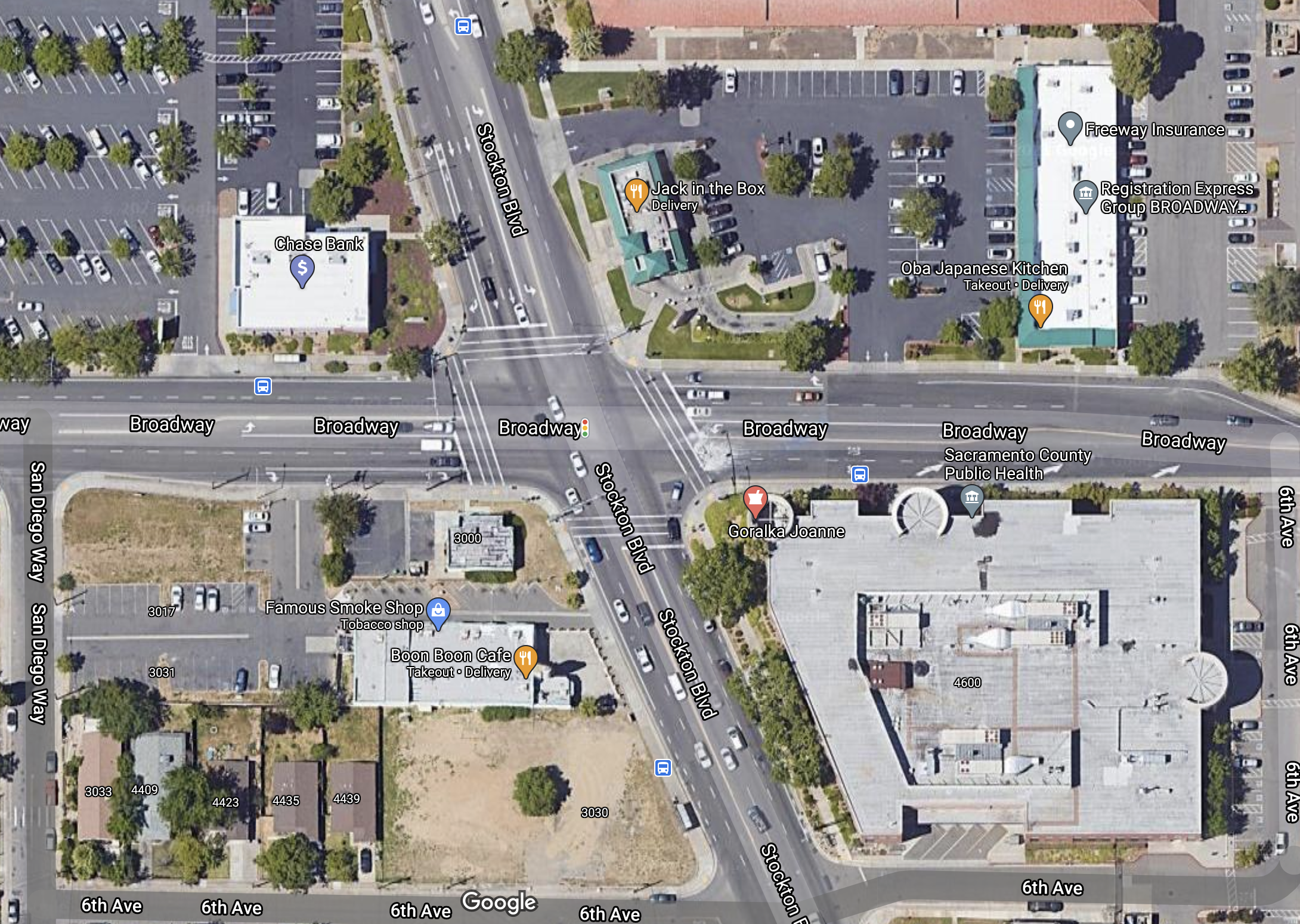
Second, a Google Maps excerpt of the intersection.

Broadway & Stockton Blvd, Google Maps

Southbound on Stockton Blvd, there is actually a bike lane between the through lane and the right hand turn lane. This is the type of facility that scares many bicyclists, riding between two potentially fast lanes of traffic. If you assume that the turn lane if inevitable, which it is not, then this is the only way to place a bike lane without significant intersection modification. Southbound on Stockton, there is no bike lane before this short bike lane shows up.

Northbound on Stockton, the bike lane is dashed from 6th Avenue to Broadway. The dashing, or skip line, is intended to indicate to both bicyclists and drivers that this is a merge area, with right-turning traffic merging to the right and through traffic merging to the left. Problem is, almost no drivers know what this means and how to act. California Vehicle Code (CVC) requires that a right turn be taken from the rightmost position (CVC 22100: Both the approach for a right-hand turn and a right-hand turn shall be made as close as practicable to the right-hand curb or edge of the roadway…). The purpose of this law is in part to ensure that bicyclists and drivers are in line with each other, so that the bicyclist is not right-hooked by the driver. In the turns section of the DMV Driver Handbook, none of the diagrams or text mention bike lanes, so it is not surprising that most people are unaware of the law and do not follow it.

Eastbound on Broadway, there is a bike lane present up to San Diego Way, the preceding street, but is absent in the next block. It is dropped in favor of a dedicated left turn lane and a dedicated right turn lane. Many bicyclists will ride the left edge of the right hand turn lane, and then proceed through the intersection. But most bicyclists will not even ride here because it is uncomfortable and unsafe. The bike lanes on Broadway are largely wasted because of this dropped bike lane. If a person doesn’t feel safe approaching an intersection, they don’t feel safe on their ride.

East of the intersection, the bike lane does not start up again until just past 6th Avenue. What the bicyclist is faced with is no bike lane in an area where two general purpose motor vehicle lanes are merging, which is a situation in which drivers are negotiating with other drivers, not paying any attention to bicyclists. There is a simple solution here, which is to make the right hand lane approaching Stockton be a right-turn only lane, so that the merge happens before the intersection, not after. That also removes the need for the existing right hand turn lane and provide space for a bicycle facility. To the east of the intersection, Broadway would be one lane only, as it becomes just one block later.

Westbound on Broadway, there is a bike lane from the east, but it is dropped 180 feet before the intersection, in favor of a right hand turn lane.

This is a flared intersection, where the roadway cross-section is wider near the intersection than on the approaching streets. The reason for this is to accommodate turning lanes. Stockton southbound has dedicated right turn and left turn lanes. Stockton northbound has a dedicated left turn lane. Broadway eastbound has dedicated right turn and left turn lanes. Broadway westbound has dedicated right turn and left turn lanes. Despite the flare, bicyclists have not been accommodated, only motor vehicle drivers.

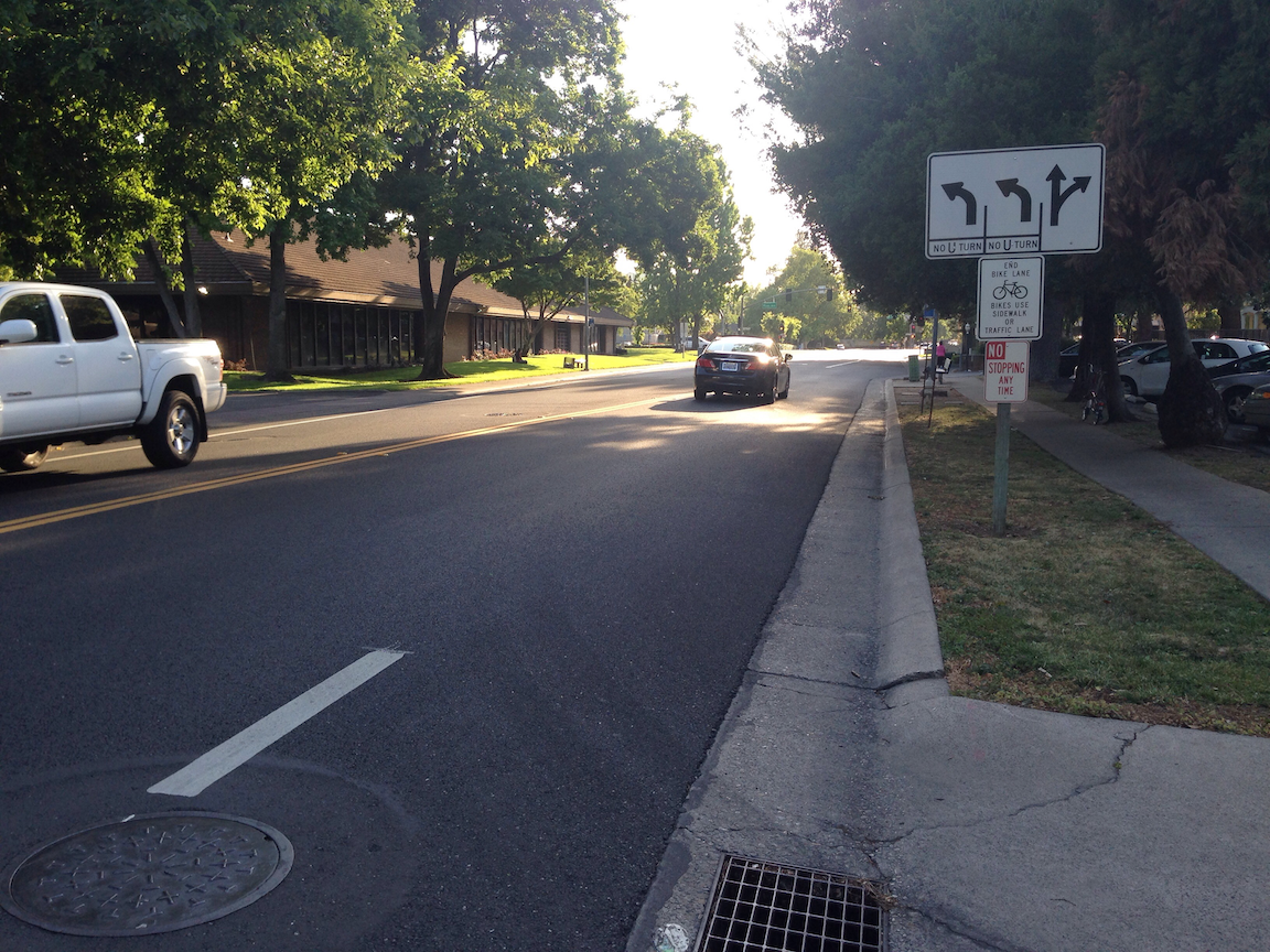
Northrop Avenue dropped bike lane, Sacramento County

I believe strongly that bike lanes should not be dropped at intersections. Never. Ever. As I’ve noted before, I’m a vehicular bicyclist who is not significantly affected by these roadway design flaws, but it is not for vehicular bicyclists that roadways should be designed. They need to be usable and comfortable for the widest possible array of bicyclist types (Four Types of Transportation Cyclists).

The perceived need by traffic engineers and drivers for dedicated turn lanes should not trump the actual needs of bicyclists for continuous and safe bicycle facilities.

It is possible to modify or reconstruct intersections so that they accommodate drivers, including turn lanes, and bicyclists, with continuous bike lanes, but that is expensive, and such changes would happen only slowly. What needs to be done NOW is to return a small part of the roadway to bicyclists by ensuring that bike lanes continue up to and through intersections. That means restriping the roadway to reallocate space. Either right turn or left turn dedicated lanes would need to be removed. I’ll leave it to the traffic engineers to decide which maintains the best flow of traffic, but I won’t leave it up to the traffic engineers to decide that it doesn’t need to be done. Though I don’t like, and most bicyclists hate, bike lanes between right turn lanes and through lanes, it is one possible solution for maintaining the right turn lane, but only when right turns are a predominant movement for the entire intersection.

Note: This is not just an issue in Sacramento. It is in the county, and the region, and the state, and everywhere in the US that I have traveled. In Oregon, bike lanes continue to the intersection, but then Oregon has the strange idea and law that bicyclists need to remain in the lane, but drivers can’t enter it. I’m not sure whether this is more safe or less safe, but it is different.

Next post, what this means for Sacramento.

How NOT to be nice to bicyclists

At intersections, some motor vehicle drivers offer to let bicyclists go first, even though it is not the bicyclist’s turn. To the driver, this may seem like a nice gesture, but it is often not taken that way by bicyclists.

Intersections are about taking turns, and about right-of-way rules. At a signalized intersection, the signal indicates whose turn it is and makes things simple, but at intersections with stop signs (two-way or four-way), or yield signs, or no signs, the driver (of the bicycle or motor vehicle) must use the rules and their eyes and their brain. These are the rules:

  1. First come, first served.
  2. First come, first served.
  3. First come, first served.
  4. If two vehicles (bicycles or motor vehicles) arrive at the intersection at the same time, at an angle, the one to the right goes first.
  5. If two vehicles (bicycles or motor vehicles) arrive at the intersection at the same time, facing each other, the one going straight goes before the one turning left.

Why did I repeat the first one three times, other than being funny? It is because too many people know the other two rules, and don’t seem to know the first.

When a motor vehicle driver yields to a bicyclist when it is the motor vehicle driver’s turn to go rather than the bicyclist’s turn, they are violating this most basic rule.

Why is this a big deal? When drivers do not take their correct turn, it leads to uncertainty for everyone, and uncertainty can lead to, at the least, frustration and anger, and quite possibly crashes.

As a bicyclist, I will not go when it is not my turn. If I did do that, I’d leave myself both physically and legally vulnerable. I have absolutely no guarantee of the behavior of other drivers who may be not polite, but taking their rightful turn, or who get impatient, or who push their way in, or even just are not paying attention.

So there is a stand-off. I shake my head no, and if that doesn’t work, I wave the driver whose turn it is to go. And then I wait. And sometimes wait, and wait, and wait. Meanwhile, I’m in a vulnerable position. Drivers behind me may get impatient and angry, not understanding why I’m not going. If I’m making a turn, I’m often stuck out in the intersection in a place that I don’t want to be hanging out, rather than having already safely completed my turn. This stand-off doesn’t increase the risk for people in motor vehicles significantly, but it very much does for bicyclists.

Motor vehicle drivers may say, “but most bicyclists don’t take their turn.” Yes, this is often true. I believe there are two things are work:

  • Many bicyclists ride just like they drive. They don’t take turns at intersections, pushing their way in before it is their turn. They don’t stop at stop signs, figuring if they never really stop, they have the right of way. Yep, the same thing motor vehicle drivers do. My anecdotal observation is that car-free bicyclists are much more likely to do the right thing at intersections than bicyclists who also drive motor vehicles. My data-based observation is that bicyclists and motor-vehicle drivers comply with stop signs at almost the exact same rate. Don’t believe me? Spend some time at an intersection and see how many drivers (of bicycles or motor vehicles) come to a full and complete stop, as the law requires. Not many.
  • Bicyclists have been trained by “polite” motor vehicle drivers that they don’t need to take their turn, and so they don’t. Every time a motor vehicle driver yields inappropriately to a bicyclist, it reinforces this behavior.

So, if you are one of those motor vehicle drivers, I ask you to stop yielding inappropriately.

“But, what about the bicyclist who doesn’t stop – I don’t want to run them over.” Or, “what about the bicyclist who doesn’t stop, I’m angry that they won’t follow the law and think themselves above it.” The answer is to be hyper-aware at every intersection. These are the places where most crashes occur, and so they are good places to pay extra attention, and use your brain rather than your emotions.

What everyone should be doing at every intersection (assuming no traffic signal) is:

  1. stop at the stop bar, or the edge of the crosswalk if there is no stop bar; if you can’t see from there, then creep forward until you can see, but only after having initially stopped
  2. look left, right, and left again before entering the intersection
  3. make eye contact with any person who may do something unexpected; this means other drivers, bicyclists and pedestrians, really, anyone else who is there
  4. yield to pedestrians
  5. continue looking left and right, as well as forward, going through the intersection; you can never be certain that someone else is not violating the law and endangering you

If you do this, then the “rogue” bicyclist who is not following the law and taking turns will not be a complete surprise to you. You will be able to respond appropriately, ensure that a crash does not occur, and go on your way. Everyone ends up safer, everyone ends up happier.

By the way, a bicyclist who does not stop when there is no one there to yield to or to take turns with is, yes, violating the law, but is not failing to practice safety. Bicyclists can see better and stop faster than any motor vehicle driver. So if you see a bicyclist at a distance, slowing and looking but not stopping when there is no one there to interact with, understand that they are acting in a completely safe manner. Take off your law enforcement vigilante hat, and smile.

pedestrian collisions in Sacramento

I often wonder if governments really focus on the issues rather than responding to incidents. In the case of pedestrians and the City of Sacramento, is the city really placing its attention, and its dollars, where they need to be to enhance the safety of pedestrians? I’ve created some maps to show where the problems lie (see note at bottom about data sources and how these were created).

The collisions mapped are:

  • Date: 01-01-2004 to 12-31-2012
  • Location: City of Sacramento only (no, I can’t explain why some are outside the city)
  • Victim role: Pedestrian
  • Victim degree of injury: Killed or Severe Injury
  • 388 collisions
  • ArcGIS link

The first map, a point map of the entire city, shows:

  • the greatest density of collisions is in downtown/midtown, but there are certainly plenty in other areas
  • almost all collisions happen at intersections, not mid-block
  • almost all collisions are associated with major streets, called arterials and collectors, which are wide and high speed, intended to move motor vehicle traffic at speed rather than provide for multi-modal transportation

pedestrian collisions, killed or severe injury
pedestrian collisions, killed or severe injury, point map

Read More »

Protected Intersections

When I posted on the North 12th Street Complete Street Project, I expressed concern about how the  cycle track to the north would transition to the bike lane to the south, and how bicyclists northbound would access the cycle track. On Wednesday I attended the project open house at City Hall. Preliminary designs presented by the contractor Echelon Transportation Group indicate one possible design for the intersection of 12th Street and C Street, a protected intersection. These conceptual design drawings are not yet available on the North 12th website, so I don’t have a drawing to share here. Comments from the open house and online will be used to revise the concepts, and they should then be available on the website for further review and comment.

The protected intersection is a design new to the United States, and so far not built anywhere in its entirety. The design is fairly common in bicycling friendly countries in Europe. The Protected Intersections for Bicyclists website provides a great video showing how the design works by providing a higher level of safety for bicyclists and pedestrians without much impact on motor vehicles. The design has not yet been included in the NACTO Urban Bikeway Design Guide, but I would guess it soon will be.

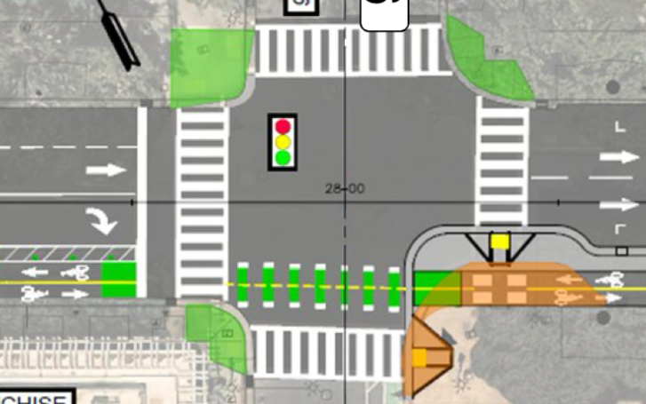
protected intersection

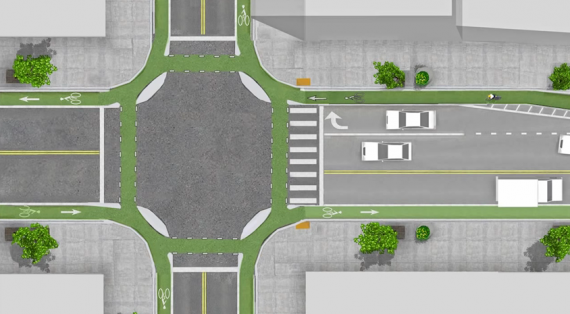
The diagram at right shows the general outline of a protected intersection. The intersection at 12th and C would look like the right half of the diagram on the west side, with the almond shaped corner medians, but would not look like the left half on the east side. Bicyclists heading south out of the cycle track would either continue south in the bike lane or use the protected intersection to turn east and then continue south on lower traffic streets. Bicyclists coming from the east would use the protected intersection to get to the west side and the cycle track.