traffic diverters for the best traffic calming

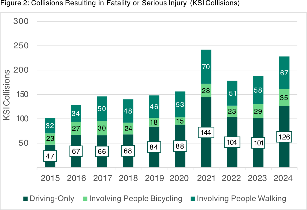
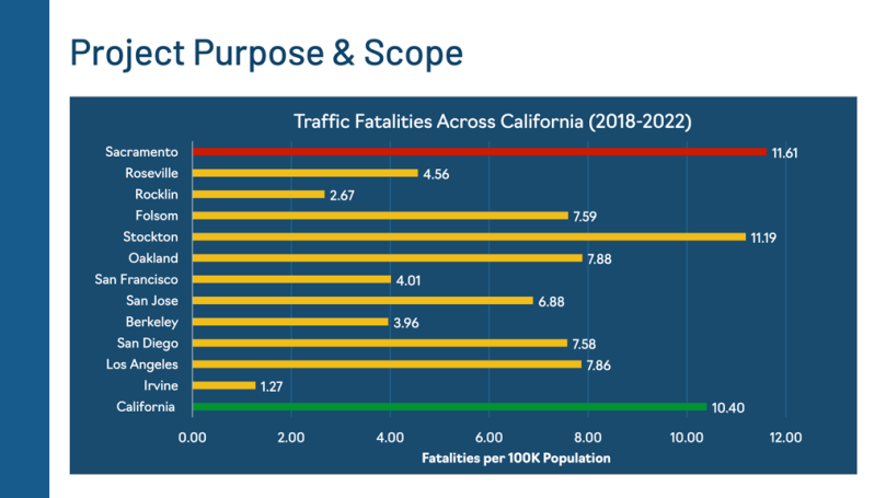
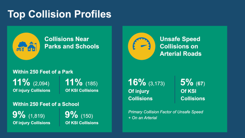
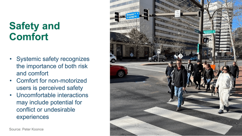
The City of Sacramento is updating its Vision Zero Action Plan. I believe that the focus of the plan should be quick-build fixes to locations where fatalities have occurred or are likely to occur. These locations are primarily intersections of arterial streets. Local streets, and to some degree collector streets, if they were not designed for more traffic and higher speeds, are mostly not the location of crashes, and even less likely fatalities because motor vehicle speeds are lower. Arterials are the problem to be solved.

That said, I want to speak up again for an infrastructure fix that has the greatest potential for reducing motor vehicle traffic. Traffic diverters would usually be on local streets, sometimes on collector streets. As such, they don’t prevent serious crashes. But they do discourage driving, and so would indirectly reduce crashes on arterials, as there would be fewer motor vehicles on all roadways. Anything that can be done to reduce the number of, and length of, car trips, will reduce fatalities.

I’ve written about traffic diverters (which are technically called modal filters, but are commonly referred to as traffic diverters) before: Strong SacTown Street Design: Modal Filters, Streets for People traffic calming, walking policies for SacCity, and many other mentions in posts.

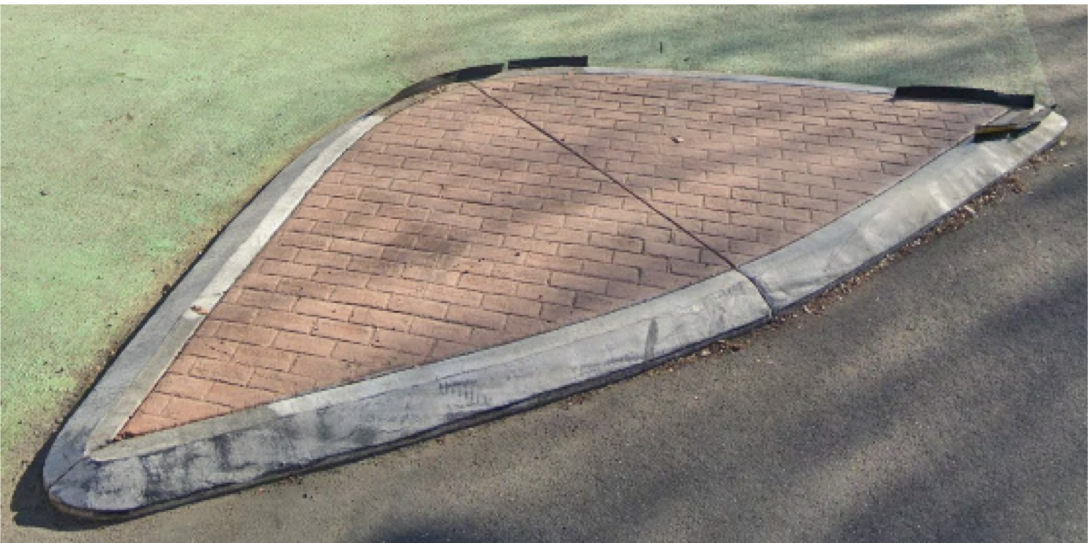
The diagram below is the the City of Sacramento Neighborhood Connections Plan, which includes the first photo. Though permanent traffic diverters, with concrete curbs and planting, are the desired state, quick-build temporary diverters have most of the safety and traffic calming effect at a fraction of the cost. Constraints: Since quick-build placement can be easily removed if they don’t work, a traffic study is NOT required. Emergency vehicles can easily and safely go around the diverter. Cost: The cost shown is for a permanent installation. A quick-build installation could probably be installed for $1000-2000.

diagram of Traffic Diverter from City of Sacramento Neighborhood Connections
Traffic Diverter diagram from City of Sacramento Neighborhood Connections

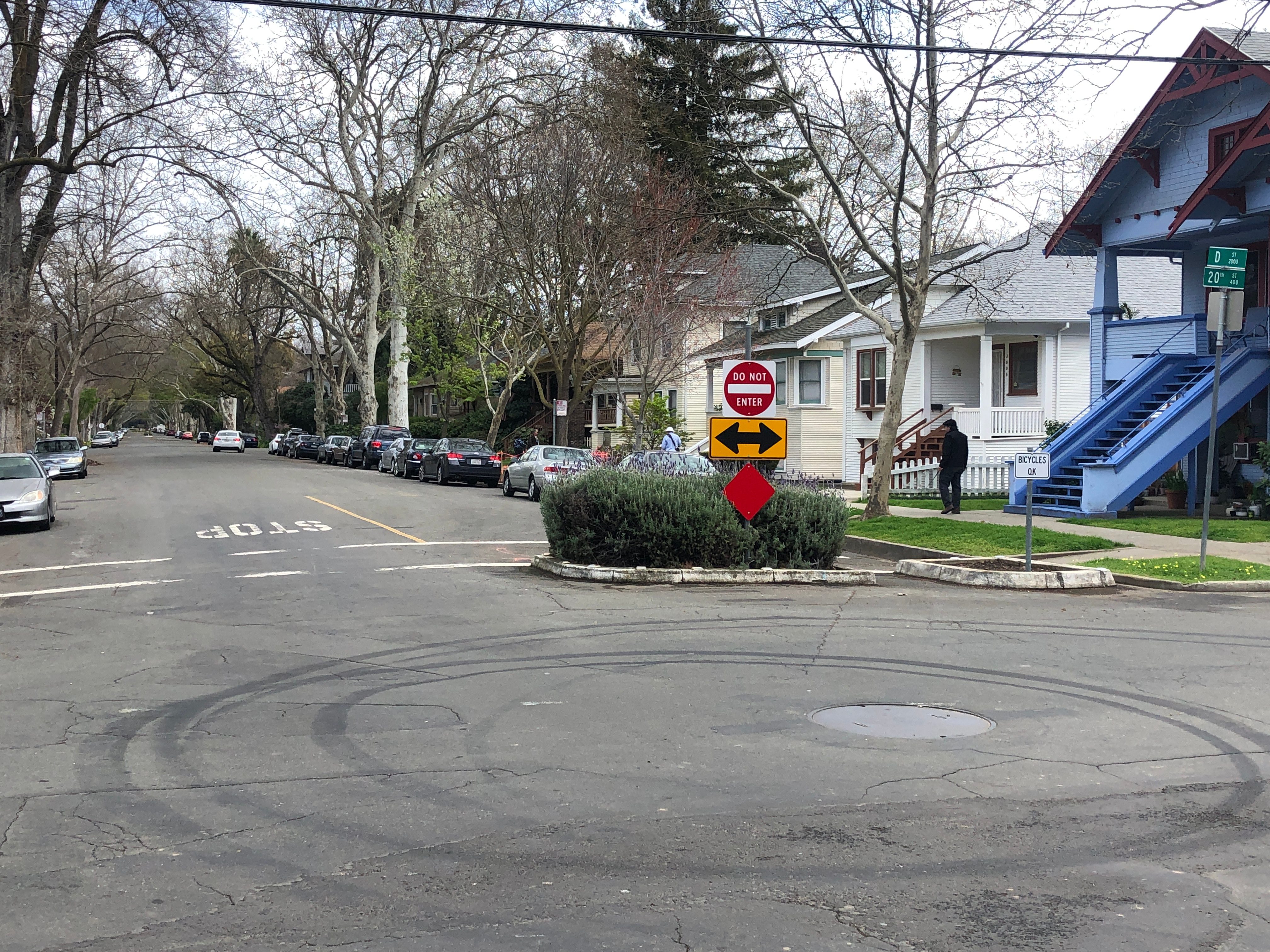
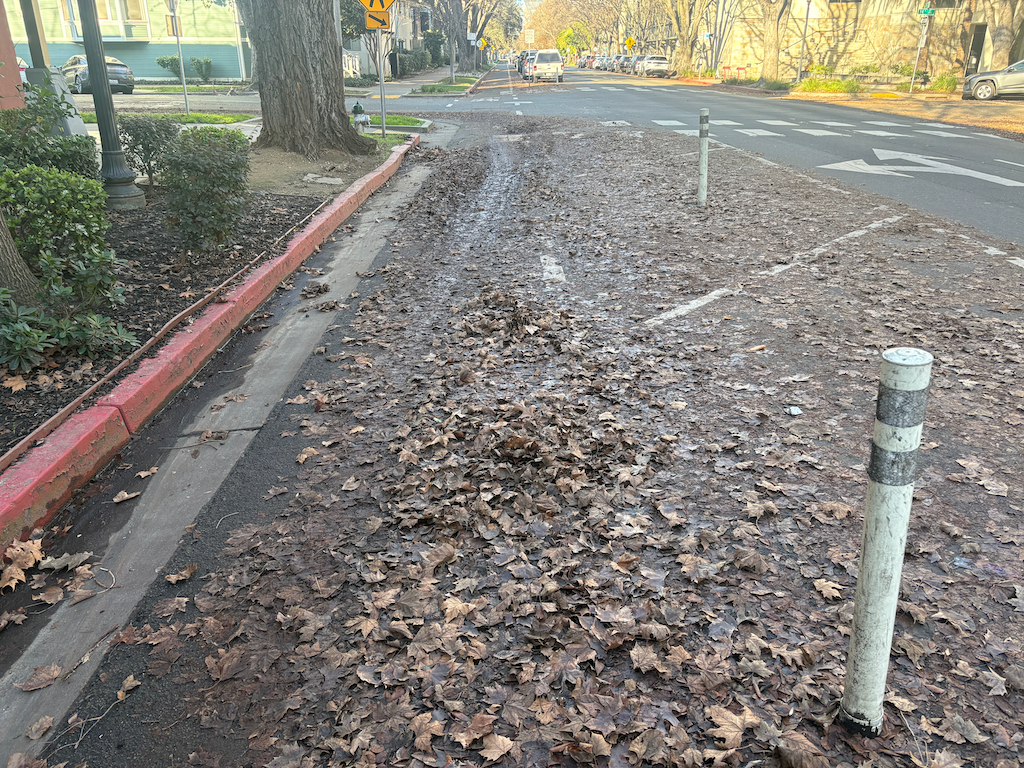
The second photo is of a traffic diverter in the northeast section of the central city, on D Street at 20th Street. The diverter allows bicyclists to pass through, which is why it is also called a modal filter. Note that it doesn’t prevent reckless driver behavior in the intersection (donuts), but it does filter reckless drivers out of D Street.

photo of SacCity traffic diverter on D St at 20th St
traffic diverter, D St at 20th St

SacCity VZAP update: stacked bar charts hide information

One of the City of Sacramento Vision Zero Action Plan Update documents, Collision Landscape Summary and Collision Profiles, on page 4, uses a stacked bar chart to graph ‘Driving-only’, ‘Involving People Bicycling’, and ‘Involving People Walking’ data. The chart obscures rather than illuminates the data. The chart from the document is below. It shows the overall trends for KSI (killed or serioiusly injured). Useful, but hides trends for each category. Though dozens of charts follow in the document, not a single one breaks out the basic data by category alone.

Below is a graphic with the data, and each category separated out. This is what should have been in the report. This is not in particular a criticism of this report or the report authors, but of the use of stacked bar charts in general. See Stacked Bars Are the Worst and many other posts on the weakness of stacked bar charts.

I think the charts below are actually useful to understanding collision trends.

SacCity vision zero action plan update survey

It is apparent that the City of Sacramento’s Vision Zero Action Plan has overall been a failure. Traffic fatalities in the city have increased, and Sacramento remains among the most unsafe cities in the state. I have written recently about the action plan update process (SacCity Vision Zero Update) and longer ago all the way back to the inception of the program (category: Vision Zero).

I believe that the failure is in large part due to the focus on improving corridors rather than specific points of concern which are mostly intersections, and a reliance on getting grants from federal, state or regional (SACOG) sources to accomplish these projects. The assumption was, and is for all transportation projects, that outside grants rather than the city’s general budget, will be the source for transportation infrastructure. The city spends very little of its own budget on transportation, beyond some basic maintenance and required grant matches. The recent quick-build program is the first time significant money has been dedicated to traffic calming and safety.

The city is offering a survey to gather community input on the action plan update, open through February 22. I just took the survey, and some screen captures are below, but I want to focus on the third page (the others are below). The top of this page offers a chance to rearrange actions in order of importance. Since these are screen captures, the six items in text are:

  • Planning and constructing large street projects that make big changes to intersections and streets to greatly improve safety, but take longer to build
  • Planning and constructing smaller projects that are quicker to build but may only modestly improve safety
  • Implementing traffic signal changes that enhance safety for everyone
  • Enforcement by police officers to address traffic violations most linked to serious or fatal crashes (for example, DUIs, red-light running, speeding)
  • Automated enforcement to address traffic violations most linked with serious or fatal crashes (for example, DUIs, red-light running, speeding)
  • Education campaigns reminding or teaching people proper rules of the road

My ranking of these is:

  1. Planning and constructing smaller projects that are quicker to build but may only modestly improve safety
  2. Automated enforcement to address traffic violations most linked with serious or fatal crashes (for example, DUIs, red-light running, speeding)
  3. Implementing traffic signal changes that enhance safety for everyone
  4. Education campaigns reminding or teaching people proper rules of the road
  5. Enforcement by police officers to address traffic violations most linked to serious or fatal crashes (for example, DUIs, red-light running, speeding)
  6. Planning and constructing large street projects that make big changes to intersections and streets to greatly improve safety, but take longer to build

Why?

  1. These small projects are in line with the city’s new Traffic Safety Initiative (quick-build) program. Though there does not seem to be a webpage for this program yet, an article in City Express summarizes the program. It is still not fully staffed and fully active. This kind of program has proven to be effective in many cities, including ones that have achieved vision zero no fatalities or greatly reduced fatalities.
  2. Automated enforcement is the best solution for speeding and red light running. Red light running is particularly epidemic in Sacramento, though a problem everywhere. There are no widely available methods for automated enforcement of failure to yield to pedestrians (people walking in the crosswalk), but this is something that could be piloted and implemented.
  3. On roadways with frequent traffic signals, traffic can be significantly slowed by setting signal timing to award safe speeds and make unsafe speeds awkward. It can even be set to a ‘green wave’ where the signals are timed to the speed of bicyclists, about 12 mph. This would be higher on my list except that the city has, to this point, demonstrated that they use signal improvements not to improve safety for walkers, but to ease traffic flow. They are claim that the entire intersection must be upgraded, at a cost approaching $1 million per intersection. That is a complete waste of taxpayer dollars.
  4. Education does not work. Of the millions of dollars spent on ‘education’ programs, there are almost no studies indicating that these programs are effective. They are feel good, but worthless.
  5. Law enforcement bias, which in integral to officers and very very slow to change, makes this an unacceptable solution in nearly all cases. In-person enforcement is as likely to result in officer escalation and harm as to preventing unsafe driver behavior. Particularly in the past, but true today, many ‘safety’ enforcements have actually been stings targeting people walking and bicycling rather than driver behavior. There may be situations in which enforcement is the last but only solution, but it should definitely not be part of the program design.
  6. Large projects are what the city has been doing, and it hasn’t worked. The city has a backlog of poorly designed and unsafe arterial roadways that will take decades (or more) and hundreds of millions of dollars (or more) to fix. We can’t wait that long, or until we find the money, to save lives. That is why small projects are the answer. Of course the projects are nice when complete, and the city has done as well as most cities its size in getting grants for these big projects, but we need to save lives tomorrow, not ten years from now. Writing grants for large projects takes an inordinate amount of staff time.

The city seems to be OK with a focus on small short-term projects, and these have been promoted by the city’s consultant (Fehr & Peers). But the public will need to support this approach, particularly against pushback from the cars-first lobby and individuals.

If you have the time and inclination, reviewing the seven documents on the city’s Vision Zero Action Plan Update page will deepen your understanding of the issue and possible solutions. If you have time for only one, the Safety Strategies (2025.06.18) is probably the most valuable.


The other pages. Note that I sometimes had started to fill out a page before capturing it.

SacCity Vision Zero Update

There are three opportunities for commenting on the City of Sacramento Vision Zero Action Plan update.

In person: Vision Zero Action Plan Community Workshop Thursday, January 29 at 5:30 pm, Sacramento City College, 3835 Freeport Boulevard registration

Virtual: Vision Zero Action Plan Virtual Workshop, Wednesday, February 4 at 5:30 pm registration

Survey

The city’s Vision Zero webpage for general information, and links for the above.

For prior Getting Around Sacramento posts on Vision Zero, see category: City of Sacramento: Vision Zero, and the more general calegory: Vision Zero.

The city’s Vision Zero effort has failed. We are still the highest traffic fatality city in the state. I believe the reason to be primarily that there were flaws in the original approach to Vision Zerio. Though I’ve written about this before, I will post again, soon.

If you are not already following Slow Down Sacramento, please do. It is the best source of information on safety from traffic violence and the city’s Vision Zero effort.

City of Sacramento Vision Zero Action Plan update graphic

Sac City abandons separated bikeways

The City of Sacramento has installed a number of separated, parking-protected bikeways, including P St, Q St, 19th St, 21st St, 9th St, 10th St, and J St. It is failing FAILING to maintain these bikeways. They have not been swept by the city since the beginning of leaf season, early November.

You can find several blocks, or portions of blocks that have been cleared, but these have not been cleared by the city. They have been cleared by landscape services contracted by adjacent property management companies, mostly for multi-family housing. It is not the responsibility of these companies to clear the bikeways, but they do so both as a community service, and to maintain a higher level of appearance for their housing and businesses.

The city should be ashamed of itself. It has created a hazard of its own making.

It would probably be better if the city returned these streets to their previous configuartion, with traditional bike lanes. At least these could be swept by the city, and to some degree are swept by the wind of passing motor vehicles.

photo of SacCity P St separated bikeway; yes there is a bikeway under the leaf piles and leaf slime
SacCity P St separated bikeway; yes there is a bikeway under the leaf piles and leaf slime

SacATC 2025-10-16

Yes, very late post, but better late than never.

The Sacramento Active Transportation Commission (SacATC) will meet Thursday, October 16, 2025, at 5:30 PM. The meeting will be at Sacramento City Hall, council chambers. The meeting is livestreamed from the Upcoming Meetings Materials page at the time of the meeting. Comments may be made in-person, or via eComment on the Upcoming Meetings Materials page up to the time of the meeting, but should be submitted well ahead of time if you wish the commission members to see the comment before the meeting. No comments are taken online.


Agenda (pdf)

Open Session Roll Call Land Acknowledgement Pledge of Allegiance Consent Calendar All items listed under the Consent Calendar are considered and acted upon by one Motion.

  1. Approval of Active Transportation Commission Meeting Minutes
  2. Active Transportation Commission Log

Discussion Calendar

  1. SacAdapt Transportation Adaptation Plan staff | presentation
  2. Connecting Howe Avenue: Safety and Mobility Plan Phase 3 Public Engagement staff | presentation
  3. Norwood Mobility Project Phase 3 Public Engagement: Public Draft Plan staff | presentation
  4. Active Transportation Commission 2025 Annual Report staff | report | presentation

Commission Staff Report

Commissioner Comments – Ideas and Questions

Public Comments-Matters Not on the Agenda

Adjournment


9th Street Separated Bikeway at SacATC

At last night’s Sacramento Active Transportation Commission (SacATC) meeting, the 9th Street Separated Bikeway was item 3 on the agenda. As is usual, I did not have a chance to review the item until shortly before the meeting, so did not post comments ahead of time, but did make comments during the meeting. I’ve broken the agenda item into staff report, plans, and presentation slides for easier access.

This was the preliminary presentation on this project, and it will be revised and come back to the commission at least once more.


My comments text, thought some particulars were left out due to the two-minute time limit:

I am glad to see the project, since it closes one of the gaps that makes the existing separated bikeways less useful.

Widths

The six-foot bikeway width does not meet NACTO recommendations (preferred width) of 8 feet or more for separated bikeways. Six feet does not allow for passing or wider bicycles, and is NOT a best practice.

NACTO table of Unidirectional Protected Bike Lane Widths

I support bin/leaf zones, but the entire buffer should be wide enough to accommodate bins, as has been implemented on some blocks of P and Q streets. I am not sure how wide this is, but it is more than 3 feet.

In order to gain the necessary width for bicycles and buffers, the street right-of-way needs to be reallocated:

  • One of the two general purpose lanes should be 9 feet (the left lane), the other 10.5 feet (the right lane), which gains 2.5 feet. The wider lane would be used by buses on SacRT Route 51. The wider lane should be marked as such, with the width painted on the pavement at every intersection to inform drivers.
  • Similarly, one of the two parking lanes should be 7.5 feet, which gains 0.5 feet, and signed or marked as a narrower parking lane. The city does not need to accommodate car bloat on every street and every parking lane.

Bikeway Protection

I support turn wedges, but they should be concrete, not solely paint and posts. Though the paint and post turn wedges provide some safety for bicyclists, and particularly for walkers, they are less safe than concrete, which the city calls ‘rolled curb turn wedge’.

SacCity photo of a rolled curb turn wedge

Any block with only an alley break in the separated bikeway should be protected by concrete curbs, not simply by paint and posts. Where driveways occur, it may be better to use paint and posts.

Marking

Whenever a bikeway crosses general purpose lanes, as it does approaching Broadway, the merge zone must be marked with green backed sharrows. Anything less is unsafe for bicyclists.

Any place where a bikeway transitions from one side to the other side is designed, there must be a bike signal to control motor vehicle traffic. In general, bicyclists need an exclusive bike phase, where no motor vehicles are turning. The side-to-side transitions on 19th Street (from left to right, just past W Street), and 21st Street (from right to left at W Street) are NOT safe for bicyclists, and as a result, there are many fewer bicyclists using these streets than was intended or is desirable. The city has resisted using bike signal faces, though the expense is a fraction of what the city routinely spends replacing functional signals and signal boxes.

Any time a bikeway is between two general purpose lanes, as it is approaching Broadway, the bikeway must be marked with continuous green paint. Somehow the plans dropped green paint between W Street and Broadway, the most confusing and potentially deadly part of the entire project.


Commissioners made a few comments:

  • Generally supportive of the project intent
  • Moore commented on green paint approaching Broadway, and asked if the transition could be earlier to reduce conflicts at the W intersection; staff response it that right-turning vehicles at W Street are the biggest conflict, other than X Street and Broadway
  • Hodel supported the red paint daylighting, and asked for green paint approaching Broadway

Apparently there were a large number of eComments on the agenda items, though I’m unsure how many related to this agenda item or the other three main items. When the meeting is over, all the eComments disappear, apparently into the ether. This is not just a problem for SacATC, but for all city meetings. Unless a citizen takes care to capture the eComments before the meeting ends, they will never know what others commented online.

The NACTO Urban Bicycle Design Guide (3rd edition, 2024) includes the diagram below within the ‘Designing Protected Bike Lanes‘ section.

diagram of NACTO One-Way Protected Bike Lanes Design Guidance
NACTO One-Way Protected Bike Lanes Design Guidance

SacATC 2025-09-18

The Sacramento Active Transportation Commission (SacATC) will meet Thursday, September 18, 2025, at 5:30 PM. The meeting will be at Sacramento City Hall, council chambers. The meeting is livestreamed from the Upcoming Meetings Materials page at the time of the meeting. Comments may be made in-person, or via eComment on the Upcoming Meetings Materials page up to the time of the meeting, but should be submitted well ahead of time if you wish the commission members to see the comment before the meeting. No comments are taken online.


Agenda (pdf)

Open Session

Roll Call

Land Acknowledgement

Pledge of Allegiance

Consent Calendar

All items listed under the Consent Calendar are considered and acted upon by one Motion.

1. Approval of Active Transportation Commission Meeting Minutes

2. Active Transportation Commission Log

Discussion Calendar

3. 9th St Separated Bikeway

4. Marysville Boulevard Vision Zero Safety Project: staff report | plans | presentation

5. Fiscal Year (FY) 2026/2027 Caltrans Sustainable Transportation Planning Grant Application

6. Active Transportation Commission 2025 Annual Report

Commission Staff Report

Commissioner Comments – Ideas and Questions

Public Comments-Matters Not on the Agenda

Adjournment


SacATC 2025-08-21

The Sacramento Active Transportation Commission (SacATC) will meet Thursday, August 21, 2025, at 5:30 PM. The meeting will be at Sacramento City Hall, council chambers. The meeting is livestreamed from the Upcoming Meetings Materials page at the time of the meeting. Comments may be made in-person, or via eComment on the Upcoming Meetings Materials page up to the time of the meeting, but should be submitted well ahead of time if you wish the commission members to see the comment before the meeting. No comments are taken online.

This is a big meeting! I hope you can attend and comment, or use eComment. I have not yet reviewed the documents, but may add additions to this post if appropriate.


Agenda (pdf)

Open Session

  • Roll Call
  • Land Acknowledgement
  • Pledge of Allegiance

Consent Calendar

  1. Approval of Active Transportation Commission Meeting Minutes
  2. Active Transportation Commission Log

Discussion Calendar

  1. Streets for People Active Transportation Plan: part 1, part 2
  2. Connecting Howe Avenue: Safety and Mobility Plan Proposed Alternatives: staff report, presentation
  3. The Norwood Mobility Project Proposed Alternatives: staff report, presentation
  4. Active Transportation Commission 2025 Annual Report: staff report, Annual Report, presentation
  • Commission Staff Report
  • Commissioner Comments – Ideas and Questions
  • Public Comments-Matters Not on the Agenda
  • Adjournment

SacCity Vision Zero Action Plan update

The City of Sacramento is undertaking an update of the 2018 Vision Zero Action Plan. A recent Sacramento City Express article, Sacramento begins Vision Zero update, launches crash data dashboard, provides a summary. The dashboard has been available since March (SacCity crash dashboard).

Getting Around Sacramento author Dan Allison is participating in the stakeholder group, wearing the Sacramento Transit Advocates and Riders (STAR) hat. Safety from traffic violence is a key part of encouraging transit use, since people need to walk or bicycle to and from transit stops and stations. Dan has attended three Vision Zero meetings, April 7, 2025 Task Force #1, June 2, 2025 Task Force #2 (the stakeholder group), and June 18, 2025 Working Group (combined Task Force and Technical Advisory).

The slides from these meetings are presented below as slideshows.

Vision Zero Action Plan update intro

Safe Systems Approach

Benchmarking & Crash Analysis

  • gallery of slides from Vision Zero Action Plan update Task Force #2
  • SacCity Vision Zero Action Plan update, Benchmarking & Crash Data Analysis presentation

Safety Improvement Strategies