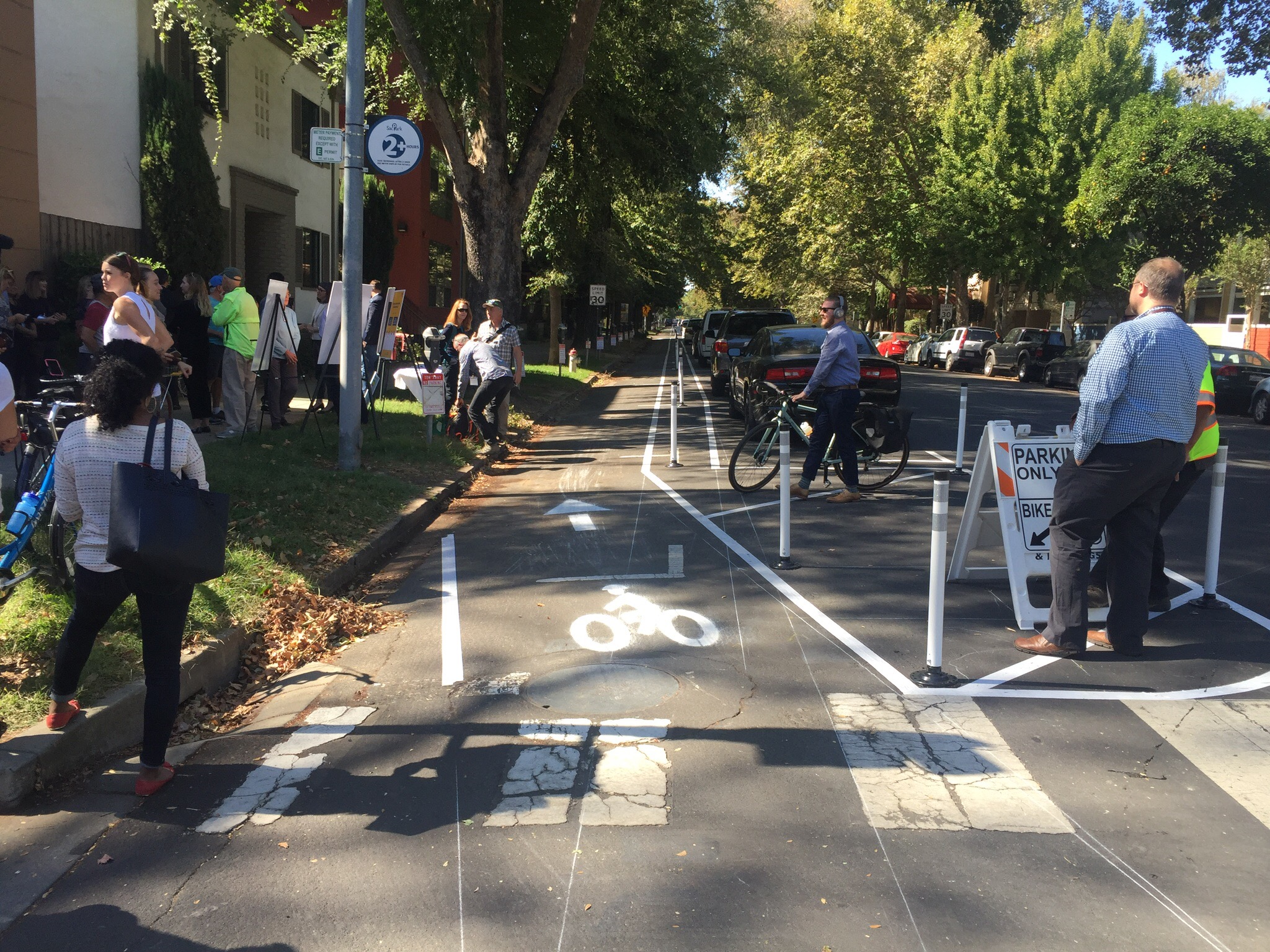
4. Sacramento, California The J Street Safety Project was designed to calm traffic, improve pedestrian crossings, provide parking-protected bikeways, and make the street more inviting for travel. They chose to add a parking-protected lane to allow people of all ages and levels to bike the grid, separated from moving traffic. Travel lanes were reduced from 3 to 2, encouraging slower vehicle speeds, decreasing pedestrian crossing lengths, and improving corridor safety. The project came out of the Central City Transportation Plan (Grid 3.0) in 2016, and is a marriage of street maintenance funding and transportation planning. They found that there was a need to calm traffic and improve pedestrian crossings, which was identified by the local businesses and residential community. The project improves pedestrian visibility by moving parking back from the intersection. It also benefits local businesses along the corridor by slowing traffic and increasing ease of crossing the corridor. So far they’ve built over 25 blocks of parking-protected bikeways this year, and have funding for another 22 blocks.
Sacramento central city is booming with construction, which I consider to be a wonderful thing. Mixed use buildings, single lot apartments andhomes, state office buildings. But the construction is having a serious impact on walkability, and often bikeability. (Note: this post is not about road construction or about temporary closures, which also need to be addressed, but not today.)
Two examples, both of state developments, but with principles applicable to private developments, will illustrate the issues. For the new California Natural Resources Agency building between O and P, and 8th and 7th, the sidewalk, parking and one travel lane on the south side (P St) were removed from service. These are not being used in any way for the project. Perhaps they will be eventually, but in the meanwhile, presumably for the entire life of the construction project, they are just sitting empty and unused. For the new O Street office building at O and 12th, the sidewalk and parking were removed from the east side of 12th between the N-O alley and the O-P alley. The section to the north, where the building is being constructed, needs closure, as the underground level is being dug and the sidewalk will be replaced. But on the section to the south, which is being used for storing construction materials, do not need to be closed. There is plenty of space on this former parking lot.
12th Street construction closure
For some of the private construction going on, of which there are many examples, some closures are no doubt necessary. But the closures seem to be occurring from the very first day of construction to the very last day of construction, even though it is needed for only part of the time.
Construction companies are doing this because they can, out of convenience or laziness. And the city is allowing them to. Each construction project requires a traffic control plan, and the permit specifies allowable areas and time frames.
When I questioned the closure on the southern section of 12th Street, Matt from Construction Services in Public Works argued that since parking was removed, it was only fair that the sidewalk access be removed. His thinking was that fairness required making everyone lose something, and that the loss of parking was equivalent to the loss of sidewalk access.
This of course is a ridiculous argument. Parking is in no way equivalent to access. And priority must be given on all roadways to the most vulnerable users, which are in order of importance, pedestrians, bicyclists, and motor vehicle drivers.
At the recent Sacramento Active Transportation Commission meeting, Jennifer said that she though there might be guidance on access restrictions, but wasn’t sure, and would look into it.
In the meanwhile, let me propose:
For any roadway with more than one lane in a direction, space will be taken from a general purpose travel lane:
If a sidewalk or informal walking path is present, pedestrian access will be preserved by the creation of a temporary sidewalk protected by delineators or barriers.
If a bike lane or separated bikeway is present, access will be preserved by the creation of a temporary bike lane protected by delineators or barriers.
For any roadway with a single lane in a direction, space will be taken by closing the general purpose lane in one direction, with appropriate detours for motor vehicles:
If a sidewalk or informal walking path is present, pedestrian access will be preserved by the creation of a temporary sidewalk protected by delineators or barriers.
If a bike lane or separated bikeway is present, access will be preserved by the creation of a temporary bike lane protected by delineators or barriers.
People are again parking in the protected bike lane (correctly called a separated bikeway in California) on 10th Street in Sacramento, approaching K Street. This happened for about two weeks after the facility was installed, and then seemed to stop as people adjusted to a different street configuration, but now it is happening again. I was not sure whether this is illegal or not, but the city confirmed that it is illegal. The parking meters are for the parking spaces in the parking lane to the left of the bike lane, not for the curb. Confusingly, the red curb was painted over, probably in a misguided attempt to follow city design guidelines without thinking about the real world.
The bike lane here needs to be changed to prevent this from happening. The 10th Street bikeway is full of compromises made with parking. Mostly, it works, despite that, but in this particular place, it does not.
You might have thought you had other plans for the evening, but…
The City of Sacramento is holding the last of four public meetings on Vision Zero and Bicycle Master Plan implementation tonight, January 31, 5:00 to 7:00PM at city hall.
The City of Sacramento is going to use street rehabilitation funds (from SB-1) to create a separated bikeway on J Street between 19th and 30th, starting this summer. The city held a public meeting last night (January 25) to gather public comments on the design elements, which have not been finalized.
I like the proposal, and see it as a significant improvement over what is there now. The general purpose travel lanes would be reduced by one, from three to two, while bike facilities would be increased from zero to one. The separated bikeway, also called a cycle track or protected bike lane (separated bikeway is the correct term in California) would be installed along the right side of the one-way street. The project will improve pedestrians safety by shortening the crossing distance over general purpose lanes, but this is more a traffic calming and bike facility project than a pedestrian project. This project is intended to be a “paint only” project that fits with the funds available. Improvements needing concrete would come later, if at all. The separated bikeways would be “protected” with flexible delineator posts between the parking lane and the bikeway, which provides increased safety but not full protection.
Though the diagrams shown last night indicate that bus stops would be at the existing curb, and the bikeway with green paint would swing around the bus stop to the left, it appears that the city is rethinking that and will use a shared bus/bike lane for the length of the bus stop. There is talk of moving bus stops to better locations, and perhaps reducing the number of stops for better service times. The only bus currently using J Street is SacRT Route 30, which has a 15 minute frequency on weekday day times, 30 minute evenings and Saturdays, and 60 minute Sundays. This is a route whose ridership probably justifies 10 minute frequency day times.
The intersections will be daylighted by removing the parking spaces that currently are right up against the crosswalks and reduce visibility between drivers and pedestrians. I completely support that and feel that the safety benefits make the loss of a few parking spaces worthwhile. I’m not against on-street parking, in fact I like it because it slows traffic, but safety is even more important.
I would like to recommend some improvements to the project as presented:
Reduce lane widths from 11 feet to 10 feet. This is the most important action that could be taken to enhance safety. The best action for pedestrian and bicyclist safety is to #SlowTheCars (@StrongTowns). The narrower the lanes, the slower the traffic, and the slower the traffic, the less severe collisions that do occur, and the less collisions. The city currently has an 11 foot standard they don’t seem ready to change, but what better time than now to create a significant project with narrower lanes, so we can directly experience the safety benefits.
Reduce the speed limit to 20 mph, and stripe the street in a way that encourages this actual speed. Again, the city is reluctant to go below 25, but there is a growing national movement to 20 mph in urban areas. Goes hand-in-hand with the lane width reduction, and is very inexpensive to implement.
Stripe the separated bikeway and street in such a way that the shared bus/bike lane at bus stops can be converted to floating bus islands with the bike lane at the curb. This configuration keeps the bus in the flow of traffic, which greatly speeds bus times as they don’t have to wait for a gap in traffic to continue. I do not know how wide the islands need to be to accommodate bus shelters, but am looking into that and will report. Another advantage of the lane width narrowing is that it would provide another two feet for the islands. The separated bikeway “lane” is seven feet, and that seems fine to me. Since this is a “paint only” project, concrete bus islands would delay it for additional finding, which I don’t want to see, but the design should be ready for bus islands as soon as they can be funded.
Reduce the number of bus stops to one every three or four blocks. The increase in service speed makes the greater walking distance worthwhile, and since the walking environment will be more appealing and safer, this is a good trade-off.
The meeting last night was the only formal opportunity to have input to this project, but I encourage you to email Jennifer Donlon-Wyant with support for the project, for these improvements I’ve presented, or you own ideas. You can also comment here, but emailing Jennifer is the first step.
The City of Sacramento has created a demonstration separated bikeway on P Street (westbound) between 15th and 13th streets. Separated bikeways, also known as protected bike lanes and cycletracks, are becoming common in progressive cities, but this is the first in Sacramanto. Yesterday the city held a “ribbon cutting” on the facility, with Mayor Steinberg and Councilmember Hansen speaking and visibly excited. The demonstration will be there through Friday, then removed. The purpose of the demonstration is to show the public what a separated bikeway looks like and how it works, and gain community feedback on the project. The city wants to install parking protected separated bikeways on portions of P and Q streets, and a buffered separated bikeway on a portion of 10th St (map below), so the demonstration hopefully will lead to permanent installations.
I was amazed at how quickly drivers adapted to the parking change. Most of the spots were filled with properly parked cars, even though the parking didn’t open until after the morning rush on parking. I was also noted that when the project was already set up for the morning inbound rush hour, there was no congestion on P St. This is the type of project that benefits drivers, bicyclists, and even people parking.
On of the questions about these facilities is how they interact with transit. The demo was placed on the left (south side westbound) to avoid interacting with buses. However, Route 6 Land Park and Route 38 P/Q Streets are low frequency 60 minute routes that should not strongly influence street allocation. An easy solution to having both separated bikeways and bus stops on the same side of the street is bus boarding islands within the parking lane or buffer, so that the bikeway passes behind the island.
I encourage you to get out and see, and use, the demo, and then provide your feedback to the city. The city will host an Open House on October 9 from 5-7 p.m. at City Hall. If you can go, please do! I’m sure there will be people there complaining about loss of a lane, and loss of parking (though there is only a slight decrease), and about change in general, so the city needs to hear from enthusiasts (we want it NOW) and thoughtful ideas for how to improve projects and install in more places. More information is available on the CityExpress page, and the Downtown Bikeways Project page.
California Bicycle Coalition (calbike) has announced the 2017 California Bicycle Summit, October 3-6 in Sacramento. Preliminary schedule and content is available, as well as registration and application to present. I encourage you to check it out. I’ve registered.
The Jedediah Smith Memorial Trail through the American River Parkway is a major commuting route for bicyclists from the suburbs to downtown, with some reverse commuting as well. It is also a recreational trail, getting a lot of use from recreational bicyclists, walkers, and families on weekends. It is great that one trail can serve so many purposes. However, the trail is being managed by Sacramento Regional Parks as though it were just a recreational trail. The trail is part of the transportation network in the county, and it should be managed as such, of course in a way that is compatible with its purposes of recreation and natural area conservation.
To be specific:
Directional signage to indicate entry and exit points and junctions with connecting trails is almost nonexistent. Mileage/time to destinations signage is non-existent.
Park ranger and maintenance vehicles regularly drive on the trail, compressing the decomposed granite walking/running shoulders that have been constructed. These then erode and become muddy, and the vehicles track mud out onto the paved trail. Much of the maintenance work could be done by cargo bike, and much of the ranger patrol could be done by bicycle, which after all works just fine for the Sacramento PD and CHP bike officers. I have never seen a regional parks employee on a bike.
When the trail is closed by flooding or fire, no information is provided about alternate routes. (see Parkway trail flood signing)
Low spots on the trail are regularly flooded under moderate rain and flooding events, resulting a broken network. (see Parkway trail low points)
The entire parkway has remained closed after the recent severe flooding episode, but regional parks has made no effort to inform the public about the sections where easy bypasses are available, such as levee top paths (which are sometimes paved and sometimes gravel, but usually passable). For example, it has been easy to ride from Guy West bridge along the levee, duck under the overpass at Howe Avenue by using paths down to and up from University Ave, and continue on to Watt Avenue, and beyond, but instead regional parks has said the parkway is closed and has not informed anyone of these alternate route. Parts of the trail were never flooded at all, yet remain closed.
Sacramento Regional Parks receives $1 million annually from the Measure A transportation sales tax in order to maintain the trail. The Sacramento Bicycle Advisory Committee (SacBAC) has questioned how the money is being spent over the years, but has never received a satisfactory answer. It is possible the money is being well spent, and I’m sure the trail is expensive to maintain, but regional parks is not being transparent.
There are almost no user facilities on the western end of the trail between Watt Avenue and Discovery Park. A drinking fountain at Howe Avenue was removed three years ago and never replaced. There are no bathrooms in this section, other than the smelly pit toilet at Watt Avenue and the almost unusable pit toilet near the Expo Parkway access point (which leaks waste into the waterway, no less). There are some benches or tables, but few and far between.
Root humps regularly develop in the trail, which is natural given the riparian zone and large trees. So far as I can tell, the paint markings to flag these hazards are all made by trail users, not by regional parks. When things get really bad, they are repaired, but long after the point at which they become dangerous. The same issue exists with beaver burrow slumps, common in the section between Expo Parkway access and Sac Northern trail.
If Sacramento Regional Parks cannot manage the trail as part of the transportation network in the county, then perhaps it is time to pass along management of the trail (not the parkway) to another agency.
Part two of posts on the parkway trail; Parkway trail low points.
When the parkway trail has been flooded this year, all the way back into December but increasingly this spring, Sacramento Regional Parks has closed various segments, and even the entire parkway at times. This is understandable. The trail is, after all, in a riparian area, and what defines riparian areas is an abundance of water.
Regional Parks has posted some information about the trail on their website, particularly as more and more of the trail has been closed, and is up-to-date with a complete closure now. In December and early January the website information was frequently out-of-date. Their Twitter account has had somewhat better information about the parkway, but it focuses mostly on motor vehicle access and not on trail access and usability.
Parts of the trail are quite usable right now, but rather than addressing those parts, all of the trail is closed.
There are two low spots on the American River Parkway trail (officially called the Jedediah Smith Memorial Trail) that flood even under moderate rainfall or flood conditions. It may seem strange to bring these low spots up when just last week perhaps 90% of the trail was underwater. The trail is in a riparian area, and so will and should flood during major flood events. But the trail is also a major commuter route for hundreds people who work downtown and live to the east, as well as a few reverse commuters like myself. After the jump, details and solutions for these two problem spots.


 People are again parking in the protected bike lane (correctly called a separated bikeway in California) on 10th Street in Sacramento, approaching K Street. This happened for about two weeks after the facility was installed, and then seemed to stop as people adjusted to a different street configuration, but now it is happening again. I was not sure whether this is illegal or not, but the city confirmed that it is illegal. The parking meters are for the parking spaces in the parking lane to the left of the bike lane, not for the curb. Confusingly, the red curb was painted over, probably in a misguided attempt to follow city design guidelines without thinking about the real world.
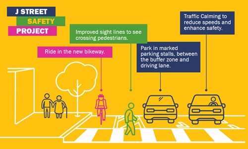 The City of Sacramento is going to use street rehabilitation funds (from SB-1) to create a separated bikeway on J Street between 19th and 30th, starting this summer. The city held a public meeting last night (January 25) to gather public comments on the design elements, which have not been finalized.
 I would like to recommend some improvements to the project as presented: