
Part two of posts on the parkway trail; Parkway trail low points.
When the parkway trail has been flooded this year, all the way back into December but increasingly this spring, Sacramento Regional Parks has closed various segments, and even the entire parkway at times. This is understandable. The trail is, after all, in a riparian area, and what defines riparian areas is an abundance of water.
Regional Parks has posted some information about the trail on their website, particularly as more and more of the trail has been closed, and is up-to-date with a complete closure now. In December and early January the website information was frequently out-of-date. Their Twitter account has had somewhat better information about the parkway, but it focuses mostly on motor vehicle access and not on trail access and usability.
Parts of the trail are quite usable right now, but rather than addressing those parts, all of the trail is closed.
When a section of trail is closed, there is usually a sign put up right at the point of closure. It is rare for signs to be put up at the point where one would leave the trail for alternate routes. So a bicyclist or walker has to go to the point of closure and then turn around, which may be interesting, but is not efficient if you are trying to get somewhere.
Many users of the parkway trail would like to see signing at the point of bicyclist and pedestrian exit, that indicates the trail is closed ahead, and the distance to the closure. The signing should also indicate alternate routes. As an example, if one has to exit at Ethan Way to avoid the powerline dip flooding and the Sac Northern junction flooding, what alternatives are available? How can a person get to where they were originally going, which is likely to be the central city via the Sac Northern bridge? Alternative routes might well include public transportation, as for example, light rail can take one across the Hwy 160 bridge into downtown when a bicycle or feet cannot.
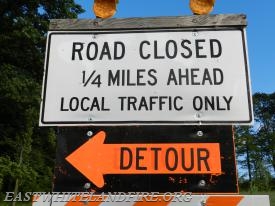 The parkway trail is part of our transportation system, as well as a recreational resource (more about that in a future post). Would a roadway or highway (for bicycle commuters, the parkway trail is the equivalent of a highway) be signed only at the point of closure? Would there be no indication of detours or alternate routes? Of course not. Except for immediately after something happens, drivers are given as much information as possible so they can make choices. Why not bicyclists and walkers?
The present flooding probably exceeds anything since 1997 (though I’ve experienced extensive flooding in the last few years, even drought years), but closures due to flooding and fire are a known and regular occurrence. Signs can be developed for each of the major access points, and stored when not in use. For minor access points, temporary signs can be printed and posted.
 Of course it is true that with a transportation system designed for motor vehicles and not bicycles, there sometimes are no viable alternate routes. Of the eight road crossings of the American River in the parkway, three prohibit bicyclists and pedestrians, and three are quite unfriendly to bicyclists and pedestrians. Of the three road crossings of the Sacramento River, one prohibits bicyclists and pedestrians, and one is unfriendly. For a motor vehicle driver, detours are frustrating and inconvenient, but for bicyclists and walkers, they can be prohibitive.

I have been hounding the City/County for some time regarding ARP issues. “Closing” the entire parkway when it’s merely flooded under the 160, and that flooding can be ridden around without even a dismount. No bollards at City owned junctions, so motorists are frequently in the Woodlake area of the parkway. Etc. etc. etc.
Up until this year, I’ve managed to avoid the 160 (the official “detour” for cyclists when the Parkway floods), and now I am pissed. Riding on a shoulder that is less than half the width of a bike lane, and then crossing two lanes of highway traffic to exit onto Del Paso (because bikes are only allowed on the 160 between Richards and Del Paso)!?!
And then on the way back, the shoulder is so wide that motorists think that it is a lane of traffic!
After seeing another commuter almost get hit on the 160 due to a motorist thinking that the shoulder was a vehicle lane, I contacted the city (again), and they said that they were already going to be working with the Bike & Ped Coordinator on Tuesday regarding the issue … hopefully something comes of it, because I am sick of my 10min commute taking close to an hour at some times.
LikeLike
Hwy 160 bridge will someday have bicycle and pedestrian facility on it, but that someday is far off. I had assumed that the bridge was closed to bicycles, but sometimes stretches of highway are open if there are no alternate routes. I though I remembered a no bicycles sign approaching the bridge from the north, but I’ve never tried from the south. Your frustrations are shared by many.
LikeLike
[…] three of posts on the parkway trail; part 2 Parkway trail flood signing; part 1 Parkway trail low points. This is it for […]
LikeLike