One of the many reasons that I travel is to see transportation facilities in different places, ways in which cities have made active transportation and transit better, or worse. I’m in Philadelphia at the moment, and one of the features that has been implemented is…
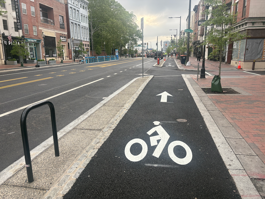
sidewalk-level bikeway on Market St in Philadelphia
These sidewalk-level separated/protected bikeways are on several blocks of Market Street, the main east-west street in Philadelphia. These are new, and were under construction during my last visit a year ago. NACTO calls these Raised Protected Bike Lanes, with designs on the Separating Protected Bike Lanes page (scroll down for this design section).
These bikeways are visually distinctive from the adjacent sidewalk, composed of different materials and colors, red brick for the sidewalk (many sidewalks in Philadelphia are brick), grey granite for the separation, and black asphalt for the bikeway. NACTO recommends a tactile warning delineator (TWD) between the sidewalk and bikeway. The granite separator and change of texture may or may not meet this criteria for visually impaired people. Though
Philadelphia downtown has a significant bicyclist mode share, but it mostly seems to be on the north-south arterials and collectors, not on east-west streets. But this may be an artifact of the time of day I observed. It has a wide variety of bike facilities: traditional bike lanes, vertical delineator ‘separated’ bikeways, two-way separated bikeways (cycle tracks), parking protected bikeways, bikeways along transit islands. I don’t know the criteria, but I suspect that available roadway width is a determinant.
Sacramento is proposing a sidewalk-level bikeway (2-way cycle track) on H Street between 9th Street and 10th Street, at City Hall. I believe the design is for paint on the existing sidewalk, not reconstruction of that section. It will be interesting to see if this design works.
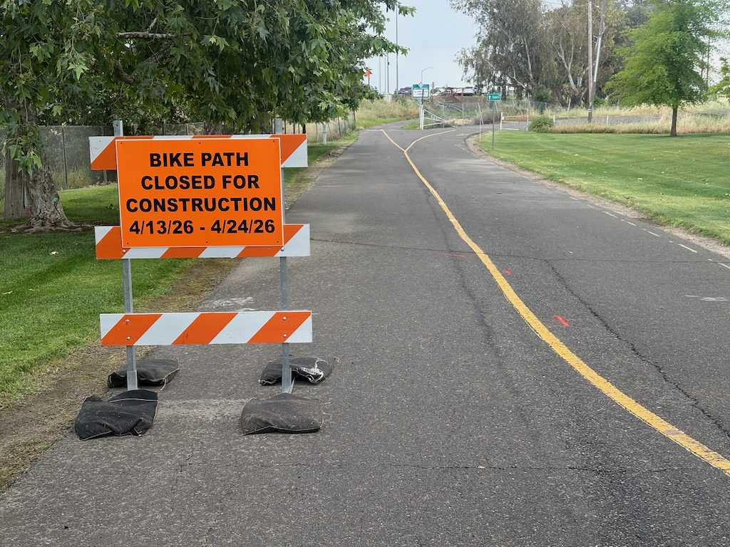
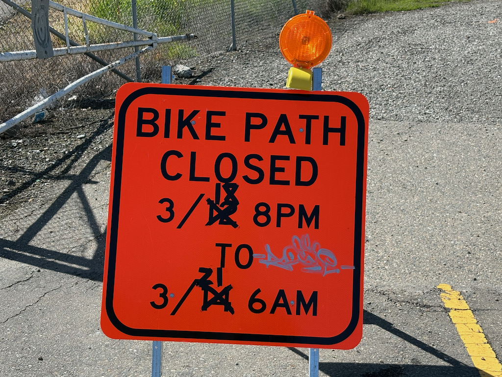
The Yolo causeway bike path will close for a week and a half starting Monday April 13 (tomorrow). The part that will close is actually very short, from the path rest area in West Sacramento to the beginning of the causeway bridge, but since there is no alternative route, the entire distance from West Sac to Davis is closed.
Presumably the closure will be to improve or replace the section of very deteriorated path as it ramps up to bridge level. This is a good thing. The problem is that most users of the path would have no way of knowing beforehand. It is not signed where the path departs West Capitol Avenue westbound, nor is it signed where the path departs County Road 32A eastbound.
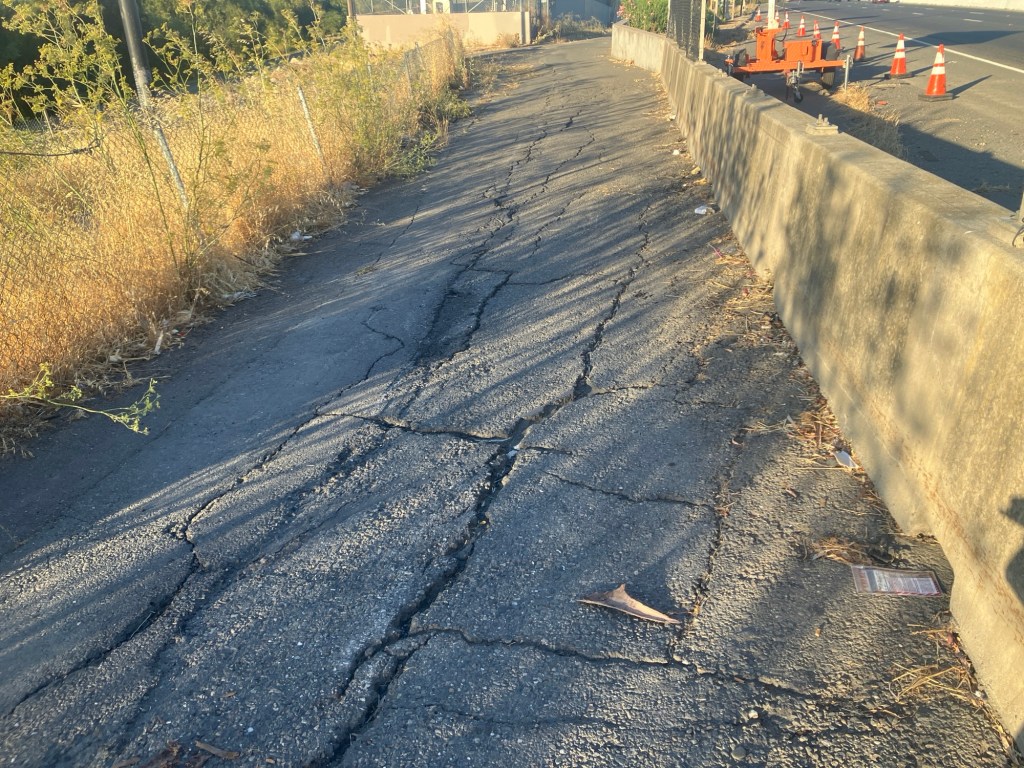
Yolo causeway bike path deteriorated pavement
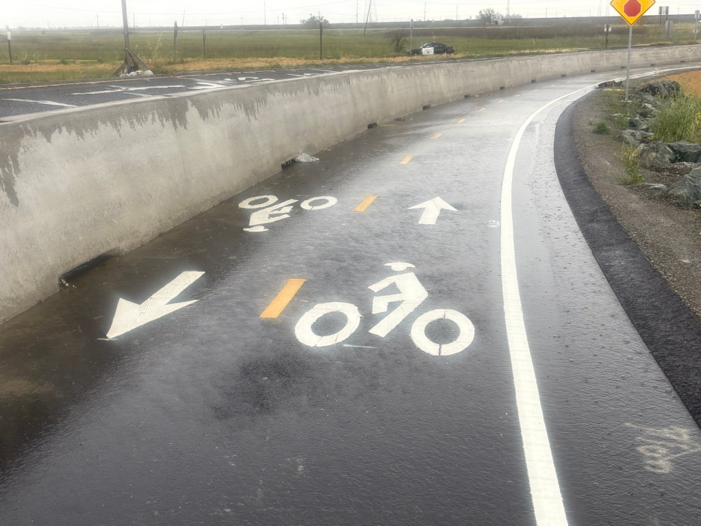
The west end has been improved. Rather than turning on to the levee, it follows the off-ramp from the freeway, protected from motor vehicles by concrete barrier ( sometimes called K-rail or Jersey barrier, but it isn’t clear if this is the term for permanent barriers). However, the junction with County Road 32A is not complete, and may have safety issues.
Yolo causeway bike path approaching County Road 32A
The drainage problems on the causeway portion of the path have not been solved, so there will be extensive puddles after rain, as yesterday. The path continues to collect debris from the highway, car and truck parts and trash. Caltrans passed on the opportunity to provide path lighting, even though electric was embedded in the new barrier. And of course noise from the highway is oppressive. As with all Caltrans projects, two steps forward and one step back.
At last night’s Sacramento Active Transportation Commission (SacATC) meeting, the 9th Street Separated Bikeway was item 3 on the agenda. As is usual, I did not have a chance to review the item until shortly before the meeting, so did not post comments ahead of time, but did make comments during the meeting. I’ve broken the agenda item into staff report, plans, and presentation slides for easier access.
This was the preliminary presentation on this project, and it will be revised and come back to the commission at least once more.
My comments text, thought some particulars were left out due to the two-minute time limit:
I am glad to see the project, since it closes one of the gaps that makes the existing separated bikeways less useful.
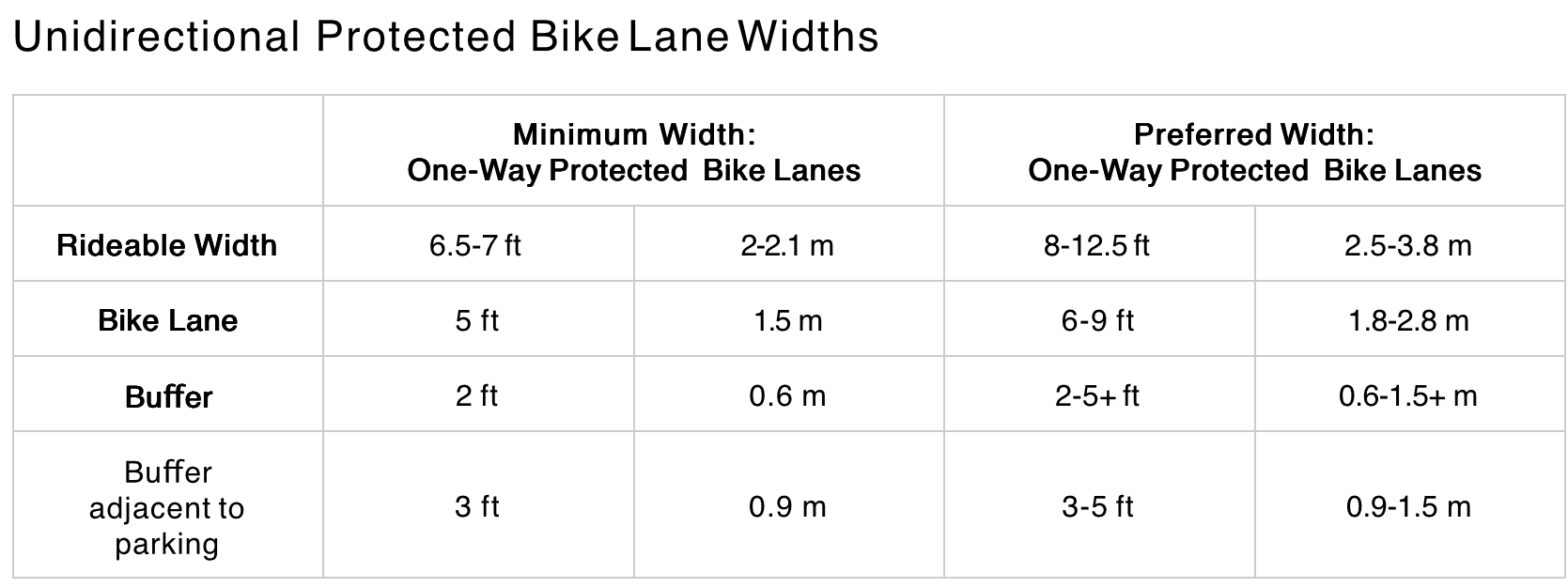
Widths
The six-foot bikeway width does not meet NACTO recommendations (preferred width) of 8 feet or more for separated bikeways. Six feet does not allow for passing or wider bicycles, and is NOT a best practice.
I support bin/leaf zones, but the entire buffer should be wide enough to accommodate bins, as has been implemented on some blocks of P and Q streets. I am not sure how wide this is, but it is more than 3 feet.
In order to gain the necessary width for bicycles and buffers, the street right-of-way needs to be reallocated:
One of the two general purpose lanes should be 9 feet (the left lane), the other 10.5 feet (the right lane), which gains 2.5 feet. The wider lane would be used by buses on SacRT Route 51. The wider lane should be marked as such, with the width painted on the pavement at every intersection to inform drivers.
Similarly, one of the two parking lanes should be 7.5 feet, which gains 0.5 feet, and signed or marked as a narrower parking lane. The city does not need to accommodate car bloat on every street and every parking lane.
Bikeway Protection
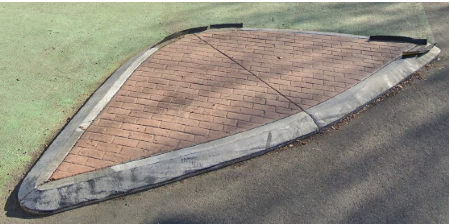
I support turn wedges, but they should be concrete, not solely paint and posts. Though the paint and post turn wedges provide some safety for bicyclists, and particularly for walkers, they are less safe than concrete, which the city calls ‘rolled curb turn wedge’.
SacCity photo of a rolled curb turn wedge
Any block with only an alley break in the separated bikeway should be protected by concrete curbs, not simply by paint and posts. Where driveways occur, it may be better to use paint and posts.
Marking
Whenever a bikeway crosses general purpose lanes, as it does approaching Broadway, the merge zone must be marked with green backed sharrows. Anything less is unsafe for bicyclists.
Any place where a bikeway transitions from one side to the other side is designed, there must be a bike signal to control motor vehicle traffic. In general, bicyclists need an exclusive bike phase, where no motor vehicles are turning. The side-to-side transitions on 19th Street (from left to right, just past W Street), and 21st Street (from right to left at W Street) are NOT safe for bicyclists, and as a result, there are many fewer bicyclists using these streets than was intended or is desirable. The city has resisted using bike signal faces, though the expense is a fraction of what the city routinely spends replacing functional signals and signal boxes.
Any time a bikeway is between two general purpose lanes, as it is approaching Broadway, the bikeway must be marked with continuous green paint. Somehow the plans dropped green paint between W Street and Broadway, the most confusing and potentially deadly part of the entire project.
Commissioners made a few comments:
Generally supportive of the project intent
Moore commented on green paint approaching Broadway, and asked if the transition could be earlier to reduce conflicts at the W intersection; staff response it that right-turning vehicles at W Street are the biggest conflict, other than X Street and Broadway
Hodel supported the red paint daylighting, and asked for green paint approaching Broadway
Apparently there were a large number of eComments on the agenda items, though I’m unsure how many related to this agenda item or the other three main items. When the meeting is over, all the eComments disappear, apparently into the ether. This is not just a problem for SacATC, but for all city meetings. Unless a citizen takes care to capture the eComments before the meeting ends, they will never know what others commented online.
The NACTO Urban Bicycle Design Guide (3rd edition, 2024) includes the diagram below within the ‘Designing Protected Bike Lanes‘ section.
NACTO One-Way Protected Bike Lanes Design Guidance
The People for Bikes analysis on Sacramento is at https://cityratings.peopleforbikes.org/cities/sacramento-ca. Note that only cities are rated, not counties, so there is no rating for unincorporated Sacramento County. Sacramento’s score was 36, Rancho Cordova’s 29, Folsom 37, Elk Grove 23, West Sacramento 25, and Citrus Heights not scored.
The lead photo on CapRadio is a concrete-separated bikeway on Broadway. But it is only one block long, and is the only one in the city.
A quote from Jennifer Donlon Wyant is revealing of exactly the problem with Sacramento bike facilities:
“M Street from Sac State to Midtown through East Sacramento is known to be an all-ages and abilities bikeway connecting schools and health care and retail, and that is shown as a high-stress facility,” she noted. “When known low-stress facilities like this are showing up as high stress, that concerns me.”
Yes, parts of M Street are great, and should be recognized with a neighborhood or greenway status. Though it is an overly wide street along much of its length, traffic is slow and light, and it meets the definition of a low-stress bikeway.
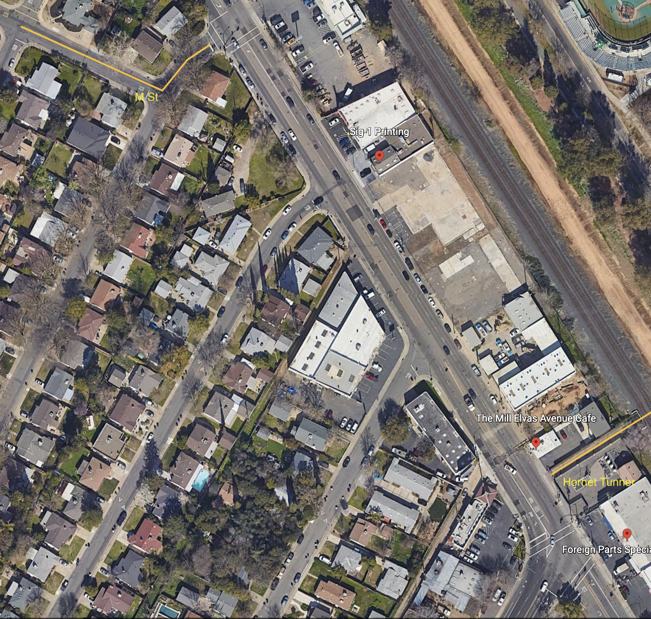
However, what happens at either end? Approaching Alhambra, M Street ends, with no bike lanes on Alhambra, and no wayfinding for how to shift to a low-stress route to continue westward. At the east end is Elvas Avenue, one of the most hazardous bike routes in the city. Bicyclists exiting onto Elvas Avenue from 62nd Street must cross four lanes of high-speed, high volume motor vehicle traffic to reach the safety of the Hornet Tunnel and SacState. Most bicyclists cross early and ride against traffic. It is slightly less hazardous to go westbound to M Street. There is no wayfinding for how to best deal with this situation.
The city has been aware of the Elvas problem for years. Nothing has been done. This blog has written about it many times: tag:Elvas-Ave.
All of the parking-protected, separated bikeways in the city are discontinuous:
10th Street northbound: starts at W Street with an awkward transition from east side to west side; ends at I Street
9th Street southbound: starts at I Street; ends at Q Street; design is very inconsistent with bike lane-only blocks
P Street westbound: starts at 21st Street; ends of 9th Street
Q Street eastbound: starts at 9th Street; ends at 21st Street
J Street eastbound: starts at 19th Street; ends at 28th Street
19th Street southbound: starts at H Street; ends at W Street with an awkward transition from east side to west side; at Broadway the route transitions to Freeport Blvd with no bike facilities
21st Street northbound: starts at W Street with an awkward transition from east side bike lane to west side separated bikeway; ends at H Street with a semi-protected bike signal
For few of these routes do the separated bikeways take you to a final destination. There are transitions to regular bike lanes, or no bike lanes at all, at the ends of each segment. That is not a connected network. It is disconnected!
Almost every advocate in the city is supportive of Jennifer Donlon Wyant and all she has accomplished to make the city more bikeable, more walkable, more livable. However, the city policy, by staff at a higher level, and city council, to spend almost none of its general fund on transportation safety, and to rely only on state and federal grants. means that the city will continue to rank low on any assessment of bicycle friendly.
Sacramento needs a connected network, and we are far from that.
Google map of Elvas Ave from 62nd St to Hornet Tunnel
I attended a Bike Advocacy Workshop hosted by the League of American Bicyclists in late March in Santa Monica. This was the third time the League had hosted the workshop, so it is evolving. It is intended to provide professional development for advocates in a similar way to that League Cycling Instructor (LCI) seminar. Though many LCIs and LCI Coaches have been requesting for many years that the League either add advocacy information to the LCI seminar, or create a separate track, apparently this was developed on the initiative of a League staff member, not on those requests.
I took this workshop, not because I necessarily think I need training in advocacy, or need the certification, but curiosity about the League’s approach to advocacy. Most League activities are at the national level, not at the state or local level, with that role taken on by other bicycle advocacy organizations. Santa Monica Spokes, the local advocacy organization, co-lead the workshop.
The workshop was a combination of presentations by advocates, field trips to look at bike facilities in Santa Monica, or which there are many, some role-playing exercises, and of course evenings outings for beer and pizza. Many of the participants work for bicycle advocacy organizations, mostly local in southern California, but with others not directly affiliated and from other regions.
The workshop was good. It would benefit from more role-playing and discussion to address the objections to bicycle facilities that often crop up, not just from an infrastructure perspective but from a livability perspective.
Santa Monica does have a lot of bicycle facilities, focusing now on physically separated bikeways on arterials and collector streets. There is a multi-use paths associated with the E/Expo light rail line. In a few places there are bicycle-only connections between streets. Some of the separated bikeways feel squeezed in, installed on relatively narrow streets without removing parking. It is better, in my view, to either remove parking from one side to create enough space for a comfortable bikeway, or just do a regular bike lane. The new NACTO Urban Bikeway Design Guide makes clear the importance of wider separated bikeways to accommodate all types of bikes, and to allow safe and comfortable passing of wider bikes such as cargo bikes and three-wheeled bikes.
A few times during the workshop the ghost of John Forrester, Effective Cycling, and vehicular cycling was trotted out to beat the dead horse. This horse has been beat for so long by so many that it is not recognizable as a horse. Advocates of bicycle infrastructure keep bringing this up, though I know of no advocates who advocate against infrastructure, though there are still, and should be, voices for the right to use the roadway.
Bike Advocacy Workshop role-playing exerciseBike Advocacy Workshop field trip on multi-use path
Note that this press release says that the path will be open again by 6:00 AM on Tuesday, March 18.
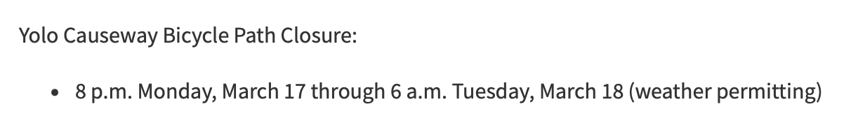
And this is the reality is:
construction on Yolo causeway bike path
Construction is completely blocking the path, at this location and several others. The work to remove the concrete barrier from the freeway is ongoing along the western section of the causeway. Some parts of the freeway are also torn up, awaiting reconstruction.
I talked to the supervisor at this construction location, and he said they are just a subcontractor, not responsible for Caltrans signing, or lack thereof. He called the general contractor, who apparently said it is my problem, not theirs. After exiting at the I-80 off-ramp (the normal entry to the path north to Yolo County 32A is not accessible), I saw a CHP officer, and reported the issue to him. He said he would pass it along. He probably will, but I doubt that either CHP nor Caltrans will do anything about it.
This is an active construction project which was not properly signed for construction. This is a violation of Caltrans procedure, and state law, and federal law.
It is absolutely typical of Caltrans District 3 (which includes Yolo and Sacramento counties) to not care about the travel or safety of bicyclists. What would it take to correct the signing, and to correct the website? Not much, but it is beyond the care and interest of Caltrans D3.
Caltrans has said that as a result of the Yolo 80 project, there would be an improved bike path. I’ve previously written about why that is very likely to be a lie: Yolo causeway bike path. Note that though Caltrans claims the current construction is just bridge rehabilitation and has nothing to do with the Yolo 80 project, that is a lie. It is safe to assume that everything Caltrans D3 says is a lie. Caltrans is a highway department, not a transportation department. They care about motor vehicles. They do not care about walkers or bicyclists or air quality or the state budget. In fact, given the high fatality rate on both under-construction and completed highway projects, they don’t really care about motor vehicle drivers either.
I will also note that the California Transportation Commission (CTC) is complicit in Caltrans D3 malfeasance, as they continue to fund projects no matter what the behavior or violation of the law. And above CTC, California State Transportation Agency, which is intended to oversee both CTC and Caltrans, but does not.
A number of organizations have come out with agenda’s for next year, and I’ll cover a few of those in several posts. First, CalBike. I participated in CalBike’s agenda reveal on December 3, and it was disappointing. Mostly videos of talking heads about the past, not much about the future. The breakout I participated in was dominated by a single person who wanted to talk about specific locations and wouldn’t let anyone get a word in edgewise about policy. But CalBike now has a page dedicated to CalBike’s Agenda for 2025, which is clearly presented. CalBike has organized support statewide for progressive legislation which encourages bicycling and makes it safer, and has supported legislation for walkers as well. There isn’t an active statewide organization for walking, unfortunately.
The agenda lists:
bicycle highways
shared streets
quick-build pilot
bike omnibus #2
bicycle safety stop
new bike boulevard classification
e-bike policy
Though e-bikes modified to be (illegal) motorcycles is not a big problem in Sacramento area, yet, it is in other places. San Francisco, where I am right now, is full of deliveristas on bikes that have pedals and chains, but top out about 40 mph. In the Lake Tahoe region, it is rich high school students. I’d like to see legislation to clearly define what is and is not an e-bike, and make sure high speed devices are banned from bike lanes and bike facilities. It is already illegal (AB 1774 Dixon, 2024) to modify an e-bike for higher speeds, or to sell devices which bypass design speed, but of course enforcement is uncertain.
The bicycle safety stop should be a no-brainer, except of course that Newsom and CHP probably don’t have brains. Treating stop signs as yield signs, slowing and yielding when necessary, is what almost all bicyclists already do, and there is nothing unsafe about it. Research has indicated that the rate of full and complete stops at stop signs is nearly the same for bicyclists and drivers, but when bicyclists stop, then are in danger of getting hit from behind by drivers not stopping, and the energy to get started again is significant, not just a press of the gas pedal.
Shared street standards are a good idea. Many locations have implemented shared streets, with different designs. As a new idea to be experimented with, wide variation was OK, but enough is known about designs now to create a standard. Some cities have continually lessened the protection and messaging on shared streets (or removed them completely, in the case of Sacramento), and standards would help prevent this erosion. I think shared streets should be more common that ‘regular’ streets. Shared streets are where people live, regular streets are where people drive.
I’m not sure whether state-recognized quick-build designs would help much. Cities are already doing these projects, and the best thing Caltrans could do is get out of the way.
Sacramento 26th St slow & active street, since terminated
Re-upping the Elvas Ave and Hornet Tunnel post from earlier this year. It has been reported to me by a number of bicyclists, and I have experienced it myself, that this section of Elvas between the Hornet Tunnel and the signal at 62nd Street has become significantly more hazardous due to the motor vehicle traffic generated by The Line (a collection of various food vendors, opened 2022) and Garden at the Line (an outdoor eating and drinking area adjacent to The Line, opened this December). There is a lot more come and go parking on Elvas, and a lot more motor vehicle traffic in and out of the parking lots. Most bicyclists ride on the sidewalk to avoid the fast-moving traffic, otherwise the crash rate would be higher. The M Street to Elvas Avenue to Hornet Tunnel route is probably the busiest in the city.
In addition to the previous post (reblog below) about the hazards for bicyclists, this area is now hazardous for walkers along and crossing Elvas.
I was there last night for the SABA social gathering, and the place was packed. People were parking along the west side of Elvas as well as on 63rd Avenue and 64th Avenue, and then trying to cross Elvas to Garden at the Line. It was nearly impossible to cross, as there are no marked crosswalks over Elvas at either street, drivers are going fast, and Elvas is not well lit. The speed limit in this section is 40 mph, which almost guarantees that walkers hit by cars will die. Sidewalks on both sides of Elvas are in poor condition, and rolled curbs are common, which are less safe for people walking than vertical curbs. There are no sidewalk buffers. While this section of Elvas is not one of the top 5 or top 10 Vision Zero corridors, it will quickly become so. In the last five years, there have been two injury crashes on this stretch, one bicyclist and one walker, both in the vicinity of Hornet Tunnel.
The city has no plans to improve safety for bicyclists or walkers on this stretch of Elvas.
The City of Sacramento is not sweeping its separated bikeways, as it promised to do when it installed them. The separated bikeways, on I St, P St, Q St, 9th St, 10th St, 19th St, and 21st St have not been swept by the city. The city has a sweeper designed specifically for these bikeways. It may be broken down, or the city may be choosing not to sweep. Some of the bikeways are being swept by landscape maintenance services associated with adjacent properties, a few spots are being swept by individual owners or residents, and even the parks department is cleaning up, but not consistently.
Q St at 14th St, separated bikeway, not swept by city
In a few places that have heavier bicycle and scooter traffic, such as P St between 15th and 14th, the leaves have turned into leaf slime, which is extremely hazardous for anyone on two wheels. I’ve seen people almost spin out here, and I have as well.
Most people seem to have realized that the place for piled leaves is NOT in the bikeway, but in the adjacent buffer, and in some locations that buffer is labeled as such. But some people are still piling in the bikeway.
Regular bike lanes are an issue as well. Most are not swept. Dry leaves are sometimes swept away be motor vehicle traffic, but once they are wet, they don’t move. If there is motor vehicle traffic across or along the bike lane, such as approaching an intersection, the leaves are quickly turned into slime. Very slippery! Be cautious anywhere there are leaves.
Palm trees – ack!
And just in case you need to be reminded, palm trees and the fronds they drop are an ongoing hazard to people walking and bicycling. A single frond can block a sidewalk from use by anyone with a mobility device. A single frond can block a bikeway or bike lane, and can throw a bike rider off their bike. With every wind storm or heavy rain storm, palm trees drop huge numbers of fronds. Why do we continue to allow this hazard for walkers and bicyclists? In a few locations where they have historic value, such as Capitol Park, they might be justifiable. But nowhere else. They need to be removed!
Caltrans and Yolo County Transportation District are proposing to widen a section of Interstate 80 from Sacramento to the Yolo/Solano county line, a project called Yolo 80. This is not just a future project, subject to funding shortfalls and lawsuits, but is actually underway, as Caltrans illegally spends funds for highway maintenance on highway widening. I have written a number of posts on Yolo 80 and managed lanes, but today is just about the bike path that parallels Interstate 80 from the west edge of West Sacramento to Davis.
I am not a commuter or regular rider on the causeway path, but I do average riding it about once a week (I like concerts and beer and Mishka’s tea), and have been doing so for about 13 years.