I was in Seattle in May, for Northwest Folklife, and am back again at the moment, reminded that I had not posted about transformations happening in Seattle. Seattle is, on the whole, a very traffic-y city with sparse bike facilities, but what is interesting is what they are doing with re-allocating roadway space to better use than motor vehicles. Bus lanes, wider sidewalks, protected bikeways, removal of parking. It is inspirational.
I have not been able to pin down whether it is official policy, but I can say for certain that the city is no longer installing paint-only door-zone bike lanes. Anywhere. All of the bike facilities are separated, some by car parking, some with planters, some with substantial vertical delineators. Almost all the new ones are either at roadway level and protected by hard curbs, or raised to sidewalk level and therefore separated from the roadway by curb and buffer strip.
I have been following the progress of the Central City Mobility Project which has now mostly completed separated bikeways on 21st Street, half of 19th Street (H to Q), most of P Street, and now going to Q Street. One of the features of the design is ‘turn wedges’ which I have written about before: where the bike lane ends – update, where the bike lane ends, Central City Mobility update. I have spent a lot of time observing driver and bicyclist behavior at the intersections which have these turn wedges installed. The wedges are marked only by white paint, though city diagrams show them having some sort of physical barrier installed in them.
Drivers are using the turn wedges, and the buffer areas of the separated bikeway, to make very high speed, very wide turns at these corners, cutting the corner where a bicyclist might be riding. The prior configuration of a regular intersection did not allow such wide and high speed turns. I have seen a number of close calls between motor vehicles and bicyclists, and walkers, for that matter, since these high speed turns cross the crosswalk as well as the bikeway. These turn wedge corners are also encouraging drivers to run red lights, even more so than the usual red light running. I saw three drivers run the red on a single signal cycle, and a driver on the cross street had to slam on their brakes to avoid a collision. I’ve seen a large number of near-misses for motor vehicles.
It is not clear whether these turn wedges are complete or not. Will the city actually install something here that prevents or at least discourages these high speed dangerous turns? I don’t know. What I do know is that in the meanwhile, these turn wedges are a clear and present danger to bicyclists.
I spent time this afternoon watching left turns from P Street westbound to 15th Street southbound. Drivers were using the buffer area and the bikeway to form two lines of left turning traffic, where there should be only one. The block of P Street was completely devoid of parked cars, so drivers were queuing into two lines way back near 16th Street. Since the intersection is in no way marked for a double left turn lane, there were motor vehicle conflicts on every signal cycle.
Sorry to be the doom-sayer, but I have to recommend that bicyclists simply not ride on these streets until the projects are truly complete, with as full a protection for bicyclist as can be achieved with these less than international best practice designs.
The city’s attitude seems to be that since the bikeways will eventually be safer, we just have to put up with the unsafe situation in the meanwhile. I completely disagree. This may be criminal behavior on the part of the city, to remove moderately safe bike lanes and replace them with unsafe bikeways. If bicyclists (or walkers or drivers) die before the project is complete, is this just a ‘whoopsie’? Professional engineers designed this project, signed off on this project, and should be inspecting the project as it goes along. Why do we then have these unsafe situations? Is is intentional? Is it indifference to bicyclists and walkers? Is it professional incompetence?
It is imperative that all construction projects accommodate walkers and bicyclists, who are even more vulnerable at these projects than normally. The attitude of ‘it will be safer later’ is completely unacceptable.
The construction company for this project is McGuire and Hester. Though many people might blame these problems on the construction company, I don’t. It is the city’s responsibility to design safe projects, during and after construction, and it is the city’s responsibility to inspect projects to see if they are complying with the design, and to fix things if not. But I strongly suspect that the construction company is doing exactly what the city told it to do.
When bicyclists using the separated bikeway on 21st Street come to I Street, they are left without any bicyclist facilities at all, in a hazardous situation. The city intends to install a bikes-only signal here to allow bicyclists to proceed when motor vehicle traffic is not moving, but until at least late July, bicyclists are on their own. See the previous posts where the bike lane ends – update and where the bike lane ends for background.
The city has recommended, in the information sign on 21st St approaching I St, that bicyclists cross I Street using the pedestrian signal. I recommend otherwise. The double left turn general purpose (motor vehicle) lanes from 21st Street northbound to I Street westbound encourage drivers to make high speed turns, with no attention to other roadway users, while the pedestrian signal shows the white walker. This was a serious problem before the reconfiguration of 21st Street, but now is worse because not only are walkers are endangered, but now bicyclists as well.
I recommend looking for gaps in traffic from 21st Street southbound (21st is two-way north of I Street with much less traffic and much lower speeds) and I Street westbound (I Street to the east is a two-way street with much less traffic and much lower speeds), and cross against the red light. Illegal, yes. But safer to be making an illegal move than competing with drivers turning left on the green light.
This intersection could be made safer in the meanwhile by two city actions: 1) Create a separate phase for walkers crossing I Street on the west leg, where the signal remains red; and 2) Prohibit left turns on red at the signal. Since this is a one-way street to one-way street turn, it is legal to turn on red, unless posted otherwise. The advantage to prohibiting left turn on red is that it will allow bicyclists to only pay attention to two opposing traffic movements rather than three. It will be necessary to prohibit left turns on red when the bike signals are installed, so why not do that now? There is a ‘left turn yield to pedestrians’ sign here, but it is small and mounted high up, so unlikely seen by drivers. Drivers may reasonably expect walkers crossing at slow speed, but are not expecting bicyclists crossing at much higher speed. It’s why bicyclists are discouraged from riding crosswalks, and why the city is wrong to be encouraging such behavior here.
At the June 15, 2023 meeting of the City of Sacramento Active Transportation Commission meeting, agenda item 5 was ‘Stone Beetland Planned Unit Development – Amendments to the Bicycle Master Plan’. The topic was about modifying the bicycle master plan so that the new bicycle facilities in this development connected with other facilities already in the master plan. But since it is the purview of the commission is to address all active transportation topics, several members of the public and of the commission asked questions and commented on the transportation aspects of the overall development plan.
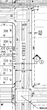
I asked why the streets were so wide, ranging from 42 feet to 74 feet, with the most common being 59 feet. Wide streets encourage drivers to speed, and so are significantly less safe than narrow streets. Another commenter and two commission members also asked about this. A 42 foot right of way should be the upper limit of street width, not the lower limit. When asked, the developer said that they had wanted narrower streets, but City of Sacramento Public Works forced the wider streets. The excuse from Public Works was apparently that as the area developed, there would be more traffic and wider streets were necessary. This is a self-fulfilling prophecy: building wider streets induces more traffic, and so the wider streets are needed to handle the motor vehicle traffic that the wider streets induced.
There were other questions about this development, including whether streets will have sidewalk buffers of sufficient width to host trees as they mature, and whether bicyclists will be able to leave the neighborhood since Cosumnes River Blvd is a high speed (55 mph!), high volume arterial that has paint-only bike lanes (which should not even be legal on a road with 55 mph posted speed limit), that very few bicyclists feel comfortable riding on. No matter what bicycle facilities the developer provides, people will be trapped in their neighborhood, unless they can drive and want to drive.
Public Works is the enemy of safe streets. Again and again the safer streets proposed by city planners and developers are nixed by someone in Public Works. There are car-brained engineers in Public Works that think the sole purpose of streets is to carry the maximum number of motor vehicles at the maximum possible speed. Despite the world changing around it, and the clearly documented hazard of wide fast streets, Public Works is living in the past, dedicated to a cars-first transportation system. I am not denying that there are progressive people in Public Works, and in Community Development as well, but somehow the outcome is always worse and less safe than the public wants.
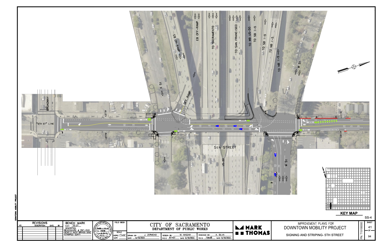
I had earlier expressed concern and lack of information about where the 5th Street one-way to two-way conversion will be handled where 5th Street passes under Hwy 50. (Yes, I know, that this is technically not Hwy 50, but everyone thinks it is, so…)
The following diagram was provided the the city and design firm (pdf). The configuration looks workable, and it probably not any less safe than the current mess. The merging of the two on-ramps into one narrower entrance will probably help to slow traffic entering the freeway, making 5th Street a bit safer. Same with the narrowing of the off-ramp. The curb line will need to be moved in a few locations to accommodate the entire street width with bike lanes, but the curbs here are already quite deteriorated, so that work would be needed in any case. It is not clear from the diagram whether the missing sidewalks in the block between Broadway and X Street will be corrected.
Note: Info on 9th Street and 10th Street added below.
For other posts on the City of Sacramento Central City Mobility Projects, see category: Central City Mobility Project. I’m not sure how interested readers are in my minor updates, but I think it is fascinating to see how the city is repurposing street right-of-way, solving problems (or not), and what is being prioritized in the overall project. I’ve not seen any signs of construction on P and Q streets, other than the ADA ramp work that has been going on for several weeks.
Turn Wedge
The project page has a diagram that I had not exactly seen anywhere before, the corner wedge, below.
Central City Mobility Project diagram turn wedge
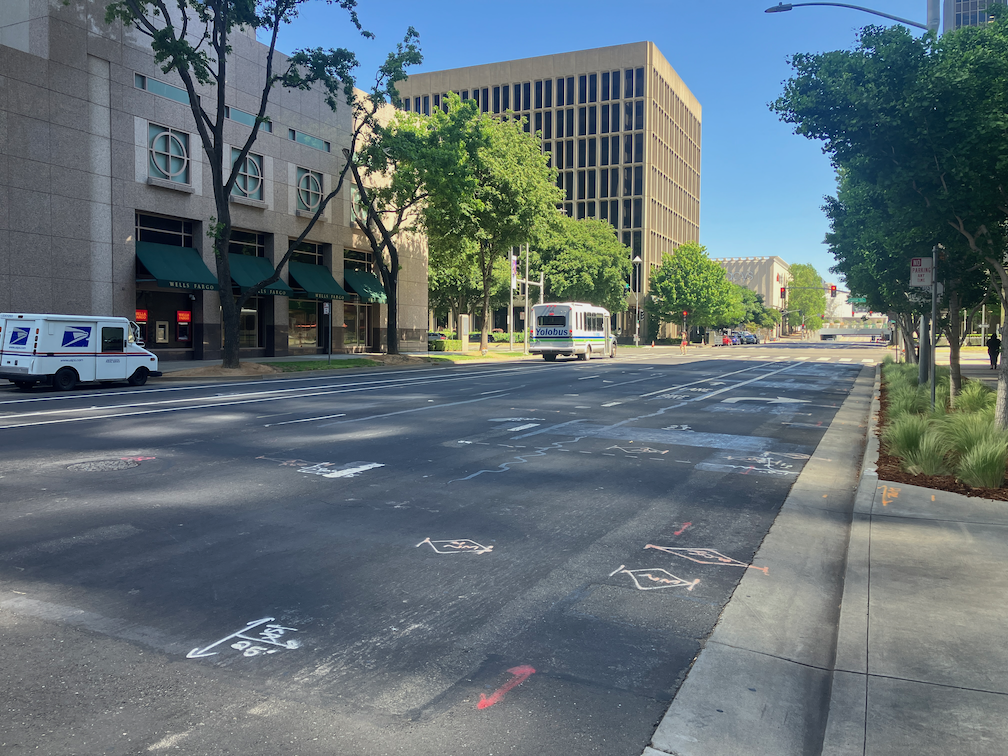
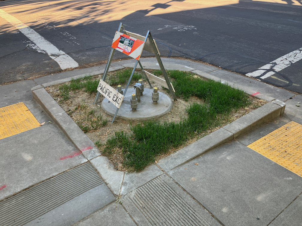
I saw a location marked for a turn wedge yesterday, at 21st St and O Street, southwest corner, below. This is a little bit like a corner of a protected intersection.
Sac_21st-St-O-St-SW_turn-wedge
5th Street Two-Way Conversion
I looked at the length of 5th Street, from Broadway to I Street. I still have no insight into what will be done under Hwy 50 where there is a one-way block that is closely tied to the freeway onramps. I have requested clarification from the city but they have not answered yet. I’ll update when I hear.
Signal bases have been installed for new signals from W Street to N Street, but not north of there. Active work was going on at N Street. At R Street, it looks like the existing pedestrian flashing light will be duplicated for the other direction. This is not a full signal, nor a user-activated signal, but always on.
Between Broadway and X Street, 5th Street is two-way, four lanes, with sharrows marked (and very faded) in the outside lane. Sharrows are no longer considered valid bikeway markings, so presumably there will be marked bike lanes here. There are three very-wide blocks for 5th Street, from N Street to L Street, and from J Street to I Street. From N to L, there are two through lanes and one or two left-turn lanes, plus parking and bike lanes. From J to I, there are two through lanes and two left-turn lanes, plus parking left and right and a bike lane on the right.
On the west side of the intersection of 5th Street and I Street, there is a crossing prohibition. I hope that the city removes this prohibition as part of the project. In most cases, freeways onramps and off-ramps being an exception, crossing prohibitions are an attempt by the transportation agency to prioritize motor vehicle volume and speed over all other considerations. They are morally wrong, and should be legally wrong.
Sac_5th-St-N-St_extra-wide
I Street Separated Bikeway (and lane reduction)
Some work has started on the I Street separated bikeway, which will run from 21st Street to 12th Street (see the importance of I Street for why it should continue west). Most corner ramps were already ADA compliant, but the few that were not have either been upgraded or are in progress. Fabric covers have been set up over drain inlets, and temporary no parking signs line the street, so I assume repaving will occur soon. I don’t see any indication of whether the separated bikeway will be on the right side or left side of the street. I Street does not have SacRT fixed route bus service, which engenders left side bikeways, though there is some commuter bus service on the street.
The project map indicates that I Street will be “lane reduction and separated bikeway”, not parking protected separated bikeway, so this will be a different configuration than 19th Street and 21st Street.
I will be interested to see if the city will address the lack of sidewalk on the south side of I Street between 16th and 15th, where the city installed a loading dock for Memorial Auditorium in place of the former sidewalk. I strongly believe that removal of sidewalks, as was done here, are criminal (Sac permanently closes sidewalk).
19th Street Repaving
It looks at though 19th Street is not going to be completely repaved in the way 21st Street was, rather, it is getting spot repaving. I don’t know whether there will be an overlay so that the new marking are on a fresh blank canvas.
9th & 10th Street Parking Protected Separated Bikeway
The 10th street parking protected separated bikeway will be extended from Broadway to Q Street. The block of Q Street to P Street has a buffered bike lane, outboard of parking in the south half, and without parking in the north half, and since that block has recently been changed, it will likely stay that way. There is a buffered bike lane from Q Street to L Street, and then a parking protected separated bikeway of variable quality from L Street to I Street. There is no bus service on 10th Street, so the right side configuration will probably be maintained throughout.
10th Street is relatively wide under Hwy 50, so no special treatment here will be needed.
On 10th Street there are ADA ramp upgrades at several locations, and several more haven’t started yet. The street has a lower rate of ADA compliance than many central city streets. There is no indication of roadwork yet.
The 9th Street parking protected separated bikeway is being extended south from L Street to Q Street. There is no indication of any sort of work here yet. Most corners already have compliant ADA ramps. There is construction on the east side of 9th (right side southbound) between L Street and Capitol Mall, and on the west side (right side southbound) between N Street and O Street, and between P Street and Q Street. All of these construction projects will probably be going on for quite some time, and this may be the last street to be modified. SacRT Bus Route 51 runs on 9th Street south of Q Street to Broadway, which is outside this project scope, but presumably argues for keeping the left side bikeway configuration throughout.
More information on the curb extensions (bulb outs) being installed on the northeast and southeast corners of the intersection of 19th Street and O Street, as part of the Central City Mobility Project. I questioned this location for curb extensions because 19th Street with have a parking protected separated bikeways on the left side (southbound) of 19th Street. (Central City Mobility update)
I received a response from the engineering firm for the project:
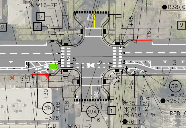
This is in response to your inquiry as to compatibility of the subject intersection revisions and parking protected bike lane. The design does account for the bulb outs at the intersection. Unfortunately, due to the space restrictions resulting from the bulb outs, it won’t be possible to provide parking protected all the way around the bulb outs. However, we are providing a transition of the bike lane at the intersection. Please take a look at the following striping design for the intersection. North is to the right with 19th Street running left to right. Hopefully this will give you a better feel for the plan:
Any reader of this blog will know that I love curb extensions. What confuses me is why this location would have been selected by the city over many other potential locations. Perhaps some of the reason it that the crossing at O Street has a moderately high walker count, but does not otherwise have a traffic signal or pedestrian signaling such as a RRFB. It is possible that the city thought these four corner curb extensions to be the most practical way of increasing safety for walkers and bicyclists crossing at this point.
The design of bringing the separated bikeway out adjacent to the general purpose travel lane, as a bike lane, is not ideal but not particularly unsafe. In fact some bicyclists prefer this design, because it increases the visibility of bicyclists by motor vehicle drivers, so that they are not ‘hidden’ behind parked cars. Though daylighting of the intersection approach can accomplish the same objective.
I would like to see green skip paint continuing through the intersection in the bike lane. These are often painted as discontinuous green rectangles with sharrows stenciled on top, called green-backed sharrows. The sharrows are out of favor with most bicyclists and some traffic engineers, I think this is a valid use of them. The main purpose of green paint (it has no legal meaning) is to increase driver awareness of bicycle facilities by highlighting conflict points, and this is definitely a conflict point.
One of the elements of the Central City Mobility Project is the conversion of 5th Street from a one-way, two-lane street, to a two-way, one-lane each direction street. Some work is underway: wiring and signal bases have been installed for the signals necessary for two way traffic at the existing signal locations. Looking at the bases, photo below, I’m guessing that there will be new signal poles and mast arms, not re-use of the existing signals equipment. That seems like a waste of money to me, but the city loves to spend money on new signals, and signal controllers.
I am not sure that many of the current signal locations are even needed. After the conversion, 5th Street will be a lower speed and probably lower volume street. Four-way stops at some major cross streets (such as T Street) might work just fine. Again, the city loves to spend money on signals, and already has unneeded signals at a number of locations (too many traffic signals?).
5th St and T St new signal base
The Central City Mobility Project map shows the 5th Street conversion as extending from Broadway to I Street. The block between Broadway and X Street is already two-way, as are the two blocks between L Street and J Street (the DOCO underpass). It is also two-way north of I Street.
I wonder what, if anything, will be done for the block between X Street and W Street, under the Hwy 50 freeway. This is a very complex block, with a freeway onramp west of 5th Street and a freeway offramp west of 5th Street. The onramp and off-ramp have separate signal phases from X Street and W Street. Traffic westbound onto the ramp, if it makes the green light, is already traveling at freeway speeds, about 65 mph as it crosses 5th Street. Similarly, but not as egregious, the off-ramp traffic, if it makes the green light, is traveling a bit below freeway speeds. I am really not sure how this complex situation can be made safe for bicyclists. Northbound bicyclists only have to deal with drivers running the red light at 5th Street from W Street, but southbound bicyclists would have to deal with multiple turning vehicle movements. In general, the only way to make complex situations like this safe is to have exclusive bicycle phases in which only bicyclists and walkers are moving, no vehicle movement or turns are permitted. But the city is very unlikely to select that safe alternative because it would lengthen the signal cycles and therefore slow motor vehicle traffic to some degree. The city doesn’t want to slow motor vehicle traffic.
The diagram below, from Google Maps, indicates the complexity of this block, but the reality on the ground is even worse.
So the neglect of the Central City Mobility Project for fixing these two blocks of I Street is disturbing. Of the people riding on I Street anywhere west of 16 Street, probably 50% are going to Sacramento Valley Station. But if you spend time on I Street looking for bicyclists, you won’t see many. The average bicyclist won’t ride on I Street. They are uncomfortable with the volume and speed of motor vehicle traffic, but more importantly, they are scared to death of these two one-block sections with only sharrows. So they drive to, or have someone drop them off at, the station. Sacramento Valley Station is the most important transit hub in the city, in the county, and in Northern California outside of the Bay Area, yet the city has neglected access to the station.
The TIRCP grant for improvements at Sacramento Valley Station may improve access from the station on H Street, but again, that is not a near term project, and it is not clear how effective it will be. Probably 80% of the riders on H Street are coming from the station. (Sac kill those sharrows on H St, H St bicycle fixes)
My observation of bicyclist numbers and destinations is based on observation and talking to some riders. It would be nice if the data were available, but I don’t have it, and apparently the city doesn’t have it, or at least has never shared it publicly. I know that the city purchased cell phone data several years ago that would have allowed them to see bicyclist patterns, but so far as I know, they only used it for motor vehicle drivers patterns.
I St shadows between 10th St and 9th St, Sacramento
I now know why all the of initial ADA ramp projects were on 21st Street. That is the first street being repaved as part of the Central City Mobility Project. 21st has been identified in the project for separated bikeways. Since there is a bus route on 21st (SacRT Route 62), I assume that the bus stops will be on the right hand side northbound, and the bikeway on the left hand side. The design shown on the project webpage shows a parking-protected separated bikeway on the left, along with a buffer zone (to protect against car doors opening). This seems to be the standard that the city has adopted, and side so far the city is placing separated bikeways only on roadways that also have bus service, presumably this design will be used in every case.
Another diagram indicates that there will be vertical delineators (K-71) in the buffers, but there are no details about the frequency. There’s are the delineators that are run over and destroyed by vehicle drivers on a regular basis, and these will suffer the same fate. The larger diameter delineators (NOT bollards, the city is incorrect in calling vertical plastic a bollard; bollards are made of metal or concrete, not plastic) that are now installed on part of J Street are not specified here. Though these don’t provide any more actual physical protection, they seem to raise doubts among drivers and get run over less often.
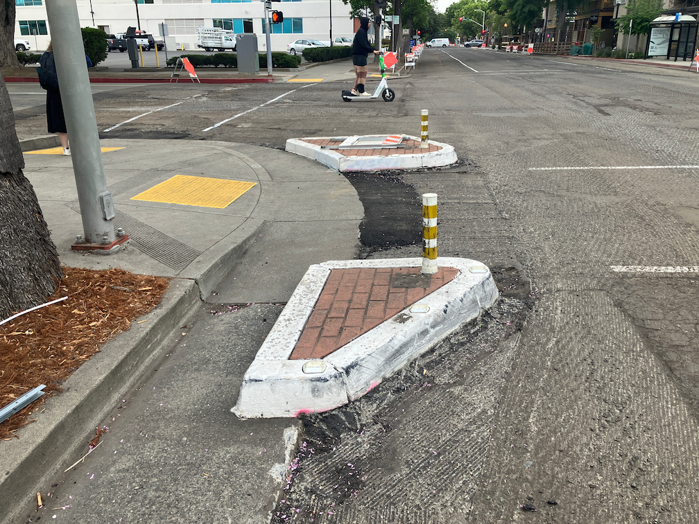
There were several curb islands along 21st Street on the left hand side. All but one have been removed. The remaining one at 21st Street and Capitol Ave may just be an oversight, but if not, it is in the middle of what is expected to be the separated bikeway.
Sac_21st-St-Capitol-Ave-SW_curb-islands
The fourteen blocks of 21st Street from W Street to H Street has been stripped down about two inches, for repaving. The restriping after paving will include the separated bikeway.
The project webpage has a diagram for the transition of a separated bikeway on the left side of 19th Street southbound to the right side of 19th Street south of W Street, which is a two-way street. However, it does not have a diagram for the transition of this 21st Street separated bikeway at the north end, where 21st Street becomes a two-way street at I Street. This is already a hazardous intersection due to the double left-turn lane from 21st Street to I Street westbound.
Separated bikeways are only as safe as their intersection treatments, and the transition from and to separated bikeways to regular bike lanes are critically important. I hope that the city has a good design for 21St Street and H Street, otherwise bicyclists will be placed in more danger than existing conditions. The solution is of course bicycle signal faces that allow bicyclists to move when other traffic is held, but the city has been reluctant to use these.