Assembly Bill 825 been introduced to the California legislature by Issac Bryan. The bill would allow bicyclists to use sidewalks where safe street bicyclist facilities have not been provide by the transportation agency. Class 1 separated paths, Class 2 bike lanes and Class 4 separated bikeways are considered safe facilities. Note that Class 3 bike routes, which are only signing and sometimes sharrows, are not considered safe under this bill. It would limit speed on sidewalks to 10 mph and require that bicyclists yield to walkers. The bill passed Assembly Committee on Transportation last week and will go to Assembly Committee on Appropriations.
I posted two day ago about bicycling on sidewalk codes in Sacramento county. The county and all the cities prohibit biking on sidewalks unless they are recognized in the bicycle plan as being bike facilities. There are very, very few such designations. The City of Sacramento takes the reverse approach, that it is legal except where signed against, and there are currently no locations signed against.
Again, I’ll say that I don’t like bicycling on sidewalks, and I don’t do it, but I completely understand why others do. The are making the best decision they can to keep themselves safe from traffic violence. This bill recognizes that reality.
Let me say that I am not in favor of bicyclists on sidewalks, but the conflict between bicyclists and walkers is often exaggerated, and bicyclists are making the best decision they perceive to keep themselves safe from traffic violence. I don’t do it, but I understand why other people do.
So what is the situation in the Sacramento region?
City of Sacramento code 10.76.010 Riding bicycles on sidewalks prohibits bicycling on sidewalks only where signed and where in-street facilities are provided. The code says:
A. No person shall ride a bicycle on a sidewalk where a sign is posted indicating that bicycling is prohibited. The city manager shall designate sidewalks where such signs are posted upon a finding that:
1. The sidewalk abuts a road that is designated a “Low Stress Bikeway” using the criteria for the Facility Selection Guidelines in the City of Sacramento Bicycle Master Plan; and
2. There is either a demonstrated or probable conflict between pedestrians and bicycles. This may be shown by information including, but not limited to: 311 reports, incident data, or estimated high pedestrian activity determined by counts or adjacent land uses and densities.
B. Subsection A of this section does not apply to the following persons:
1. City employees acting within the course and scope of employment, including but not limited to:
a. Peace officers, as defined in California Penal Code section 830.
b. Emergency medical personnel as designated by the fire chief of the city.
c. Parking enforcement officers.
2. Children under the age of 18 years old and an accompanying adult.
C. Where bicycling on a sidewalk is permitted, the following apply:
1. Bicyclists must yield the right-of-way to pedestrians by slowing down, stopping, or dismounting, as needed.
2. Before passing a pedestrian traveling in the same direction, bicyclists must give the pedestrian an audible warning.
D. The city manager or designee shall report to the city council annually regarding the impacts of sections 10.76.010 and 10.76.030. (Ord. 2019-007 § 2; Ord. 2017-0033 § 1; Ord. 2016-0024 § 1; prior code § 25.05.070)
There are some designated bike routes on sidewalks in the City of Sacramento, which were designated before this code came into effect and are still valid. N Street between 8th Street and 15th Street, and the area through the convention center/performance center between 13th Street and 14th Street.
SABA has a summary of sidewalk riding rules, on Sharing the Road page, scroll down to ‘Is it legal to ride on the sidewalk? This page may be out of date.
Note that the County of Sacramento, Elk Grove, and Rancho Cordova code sections are identical, and the Folsom and Galt code sections are identical, examples of mindless copying of code from other locales.
I do not have any information on whether these codes are being enforced in a discriminatory way, but given the almost universal pattern of law enforcement oppression of people of color, I’d not be the least surprised.
On the positive side, AB-825 Vehicles: bicycling on sidewalks (Bryan) has been introduced which would prohibit sidewalk prohibitions except where there are high quality bicycle facilities available on the street, invalidating all of these code sections except, perhaps, the City of Sacramento. The relevant paragraph is: Notwithstanding paragraph (1), a local authority shall not prohibit the operation of a bicycle on a sidewalk adjacent to a highway or corridor that does not include a Class I, Class II, or Class IV bikeway, as defined in Section 890.4 of the Streets and Highway Code.
I hope readers will support this legislation. The bill passed the Assembly Committee on Transportation on March 20, 2023, and was referred to Assembly Committee on Appropriations, but not yet scheduled. See also Streetsblog CA Traffic Safety Bills Pass First Committee.
If passed, the legislation might well cause cities and counties to accelerate projects to add safe bicycling facilities to streets, in order to reduce sidewalk riding. One can hope.
Given the issues raised by the need for wider bikeways to accommodate wider devices and passing, the topic of my bike lane widths post, I am starting to think more and more about sidewalk-level bikeways, where the bikeway is at the same level as the sidewalk, and not at street level. The street-edge curb provides a good separation between motor vehicles and bicyclists and walkers (not perfect, drivers do ‘accidentally’ or intentional cross curbs). I am concerned that as street-level bikeways become wider, there will be more and more motor vehicle intrusions.
Here are are two diagrams from the Portland Bureau of Transportation (PBOT) Pedestrian Design Guide (2022), page 28. The first uses a tactile divider between the sidewalk and bikeway, the second a buffer similar to the regular sidewalk buffer, but with reduced width due to the greater separation from motor vehicle traffic as compared to regular sidewalks. Note that the street classification system that PBOT uses is interesting, but probably more than is needed in Sacramento for the Street Design Standards update.
I just came across the NACTO publication Designing for Small Things With Wheels, released February 2023. I’m still digesting the publication, which is available online for download. Already it has been eye-opening for me, a person who used to keep up with bikeway designs, but hasn’t paid much attention recently.
The working paper’s basic premise is that bikeways must be designed for the modern complement of devices, with widely varying widths, and also that bikeways must be designed so that people can safely and easily pass each other. Bike lanes have gradually evolved from 4 feet to 5 feet to 6 feet, but at least in Sacramento and the region, have not gone beyond that. But the working paper indicates that we need to start with 8 feet, to accommodate cargo bikes which are becoming much more common in the region, and go up from there. A chart from the working paper is below (page 11).
chart for bikeway width, NACTO Designing for Small Things with Wheelschart for two-way bikeway width, NACTO Designing for Small Things with Wheels
Given that I believe that motor vehicle design speeds over 30 mph require separate bikeways to keep riders of all ages and abilities safe, this means future separated bikeways should be a minimum of 8 feet. However, bikeways this wide encourage motor vehicle drivers to use them for travel, and to park in them, ‘for just a moment’ or longer. My take is that this means we must create bikeways that are at the sidewalk level, or if street level, that are completely protected by hard infrastructure such as curbs. Paint and vertical delineators (soft hit posts) will not do it. So, I need to throw out all the previous designs that I’ve suggested for streets with protected bikeways. I also need to give serious consideration to sidewalk-level bikeways that place a curb between any motor vehicle use and users of small wheels. Where does that leave parking protected bikeways that use parked cars as the buffer, at least when the parked cars are there? I’m not sure. Like I said, this is eye-opening and I’ll need to do a lot more thinking and research.
What I still do think is that bike facilities necessary depend on street design speeds (which are not currently but should be the same as posted speeds)
20 mph or less – no bicycle facilities needed
21 to 30 mph – standard bike lanes (Class 2 in California)
above 30 mph – separated bikeways (Class 4 in California)
Yes, this does affect what I was thinking about writing for bicycle facilities in my series on the City of Sacramento update of Street Design Standards.
H Street is commonly used by bicyclists leaving Sacramento Valley Station, and others as well. It has decent bicycle facilities except for some gaps.
H Street has a bike lane on the south side from 5th Street to 16th St, except one block, 7th Street to 8th Street. There is absolutely no reason for this gap. This is the section between the Sacramento County Administration Building on the south and a decked parking garage on the north. The parking seems to be there for the convenience of people working in the building, as there does not seem to be turnover of the parking spots. There is ample parking in the garage. This parking should be removed and a bike lane painted IMMEDIATELY. No excuses. A common quote in the bicyclist community is “sharrows are bullshit”, and this is the case here, where the city has preferenced motor vehicle drivers over bicyclist safety.
H St parking and sharrows from 7th St to 8th St
There is a bike lane on the north side between 7th Street and 13th Street. Bike lanes on the left side of one-way streets are much less used than right side bike lanes, but are useful.
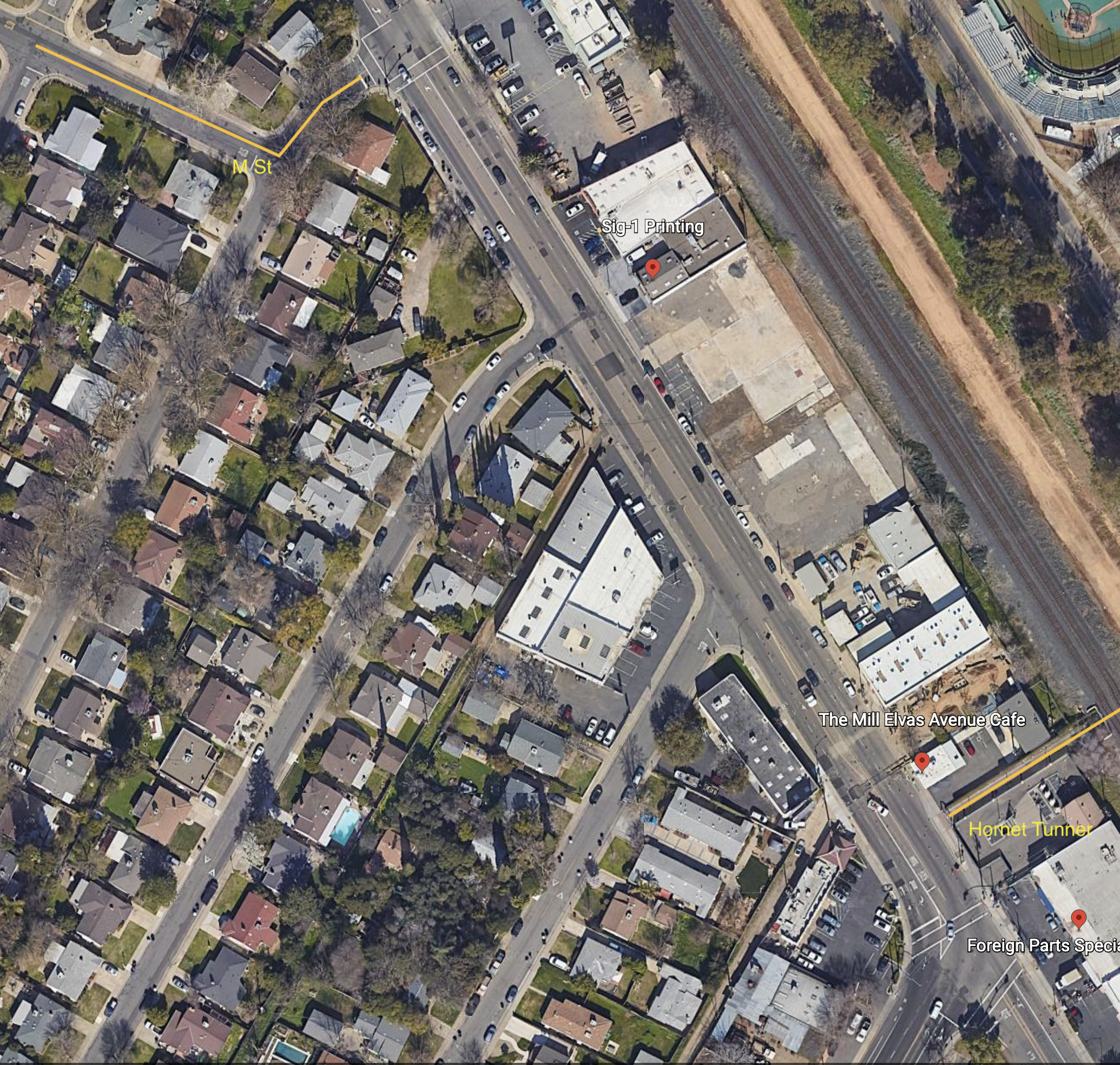
I have long been planning to write about the extremely poor bicyclist facilities from M Street to Hornet Tunnel, which is a major access point for Sac State.
M Street is a major east-west bicycle route, with some but not all of it marked as a bicycle route. If the city used the bicycle boulevard designation, it would be designated a bicycle boulevard. M Street forms an uncontrolled T-intersection with 62nd Street, which leads a short way left to a signalized T-intersection with Elvas Ave.
Hornet Tunnel is a major access point to Sac State campus, probably second only to the Guy West bridge access on the north side.
The map below shows M Street, 62nd Street, Elvas Ave, and Hornet Tunnel, as it exists.
The route from M Street to Hornet Tunnel is heavily used by bicyclists, both students and people passing through to the American River Parkway paths. It would be much more heavily used if it were safe, but it is not.
Eastbound to campus, one must cross over four lanes somewhere between 62nd Street and the median along Elvas Ave, and then ride on the wrong side of the street to reach Hornet Tunnel. Westbound, it is not bad, only having to merge over the northbound lanes to a dedicated left turn lane to 62nd Street. The signal here is surprisingly responsive to bicyclists, so the wait is usually short.
At the 62nd Street & Elvas Ave intersection, Elvas is 62 feet wide, 70 feet with sidewalks. There are shoulder stripes setting off unofficial parking, one southbound lane, one center turn lane, and two northbound lanes. At 64th Ave, Elvas is 68 feet wide, 76 feet with sideewalks. At Hornet Tunnel, Elvas is 63 feet wide, 77 feet with sidewalks, with two northbound lanes and three southbound lanes, two of which are dedicated right turn lanes to 65th Street. Elvas was formerly wider at Hornet Tunnel, but some sidewalk was added there to ease crowding at the tunnel entrance/exit. Given the city-preferred, though unnecessarily wide 11 foot travel lanes, there is room for six lanes of traffic here! That means there is ample room for bicycle facilities. But there are none present.
Some bicyclists take the striped shoulders to be bike lanes, but they are not. The city’s 2018 Bikeway Master Plan shows this section of Elvas between 65th Street and Hornet Tunnel as a Class 2 (on-street) bike lane, but this is false. It is not indicated as such with either pavement markings or signage. Though the shoulder stripe southbound has the dashed marking often used to indicate a bike lane approaching an intersection, this is a fake. It is NOT a bike lane. People park along this stretch, so even if it were a bike lane, it would not be safe nor meet minimal standards for a bike lane.
Solutions
What street redesign and reallocation would make is safer for bicyclists?
First, for northbound bicyclists, there should be a separated bikeway on the right side of the street. Along this section, there are four driveways and a stretch of street-oriented perpendicular parking (where vehicles enter directly into parking spaces from the street). There is a section of 270 feet with no existing buildings. Though there could be parking protected bikeway along here, I don’t think the parking is even needed. Instead, this is probably a good location for a curb separated bikeway, with hard curb to prevent encroachment on bicyclists. The curb would be cut only for driveways which are currently in use. The existing parking along this stretch is used mostly by students to avoid paying on-campus parking fees. All the businesses have onsite parking. The one business that might reasonably need short-term parking on Elvas is The Mill coffee shop. Separated bikeways work best with long stretches without driveways, but one here is workable.
Southbound is more complicated. If there were a bike lane or separated bikeway on the southbound side of Elvas, bicyclists would still need to cross to Hornet Tunnel, at a location where there is currently no way to do so. I see three options:
First, have bicyclists ride south to the existing 65th Street & Elvas Ave intersection, and use the crosswalk on the north side to cross over and then go north to the tunnel. This is very awkward, out of the way, and encourages bicyclists to use a crosswalk, which is not illegal but poor practice.
Second is to create a two-way separated bikeway (often called a cycletrack) on the east side of Elvas, from 62nd Street to the tunnel. A separate bicyclist signal phase would need to be created for northbound bicyclists to cross to 62nd Street, and southbound bicyclists to cross to the east side of Elvas Ave. An advantage to this solution is that parking on the west side of Elvas does not need to be changed, though it can be reasonably argued that there should be at least a regular bike lane here for bicyclists who are not going to the tunnel, but continuing south on Elvas or south on 65th Street.
Third, have bicyclists continue southbound on Elvas, but create a clear zone for crossing to the tunnel by signalization. Northbound motor vehicles would be held by the existing signal at the intersection of 65th Street and Elvas Ave, while southbound motor vehicles would be held at a stop line just north of the tunnel by new signal heads. Bicyclists would cross to the tunnel during the red phase. There would need to be queuing area for southbound bicyclists, since they would exceed the stacking capacity of the bike lane during busy times. This option probably slows motor vehicle throughput more than the other options.
No matter which solution, the sidewalks along Elvas Ave should be repaired and widened, and street trees should be planted. And of course the street needs to be repaved.
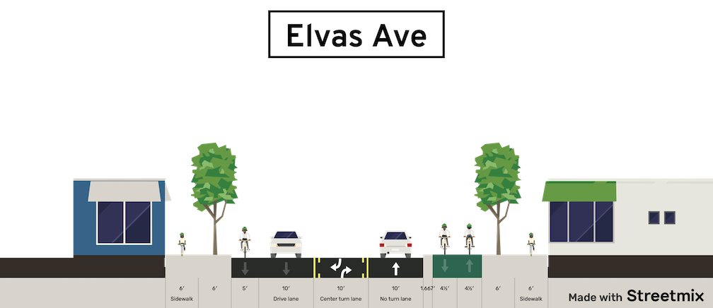
Below is a Streetsmix diagram showing one possible configuration (looking north) with a two-way separated bikeway (cycletrack) on the east side, along with wider sidewalks and trees in a planing strip, and a southbound regular bike lane. And yes, all this fits in the existing over-wide Elvas Ave right-of-way!
Note: Added information on proposed streetcar alignment below.
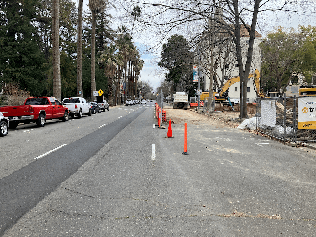
N Street in downtown Sacramento, from 3rd Street to 15th Street, is a three lane street with parking on both sides. There are no bicycle facilities. For part of the stretch, from 8th Street to 15th St, the sidewalk on the north side is a designated bike route, and is signed as such. Currently, this route alongside Capitol Park is closed due to annex construction, and not alternative has been provided. The city has made the choice to offer nearly unlimited capacity for motor vehicle drivers, but to dump walkers and bicyclists onto the same sidewalk. Some of the time this sharing works, but not when it is at all busy with either walkers or bicyclists.
N Street does not need, and has never needed, three motor vehicle lanes. Since the pandemic, the street is empty most of the day, with very short periods of heavier traffic, but it is never congested. Even before the pandemic, there was only about 20 minutes a weekday when the street could have, perhaps, be considered congested. Frequent construction projects, both before and during the pandemic, have narrowed N Street from three lanes to two, and even to one for shorter periods of time. When there was one lane, traffic was slow (a good thing!) but never really backed up.
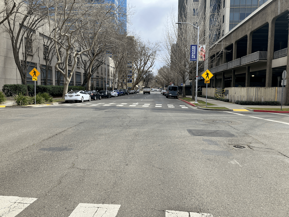
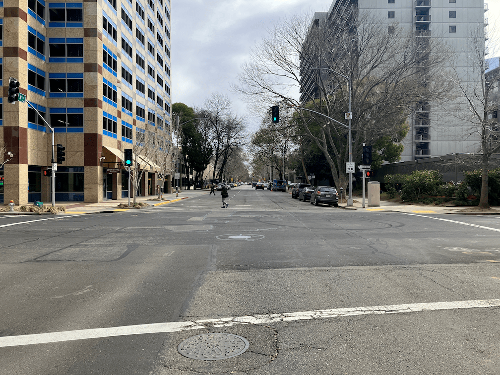
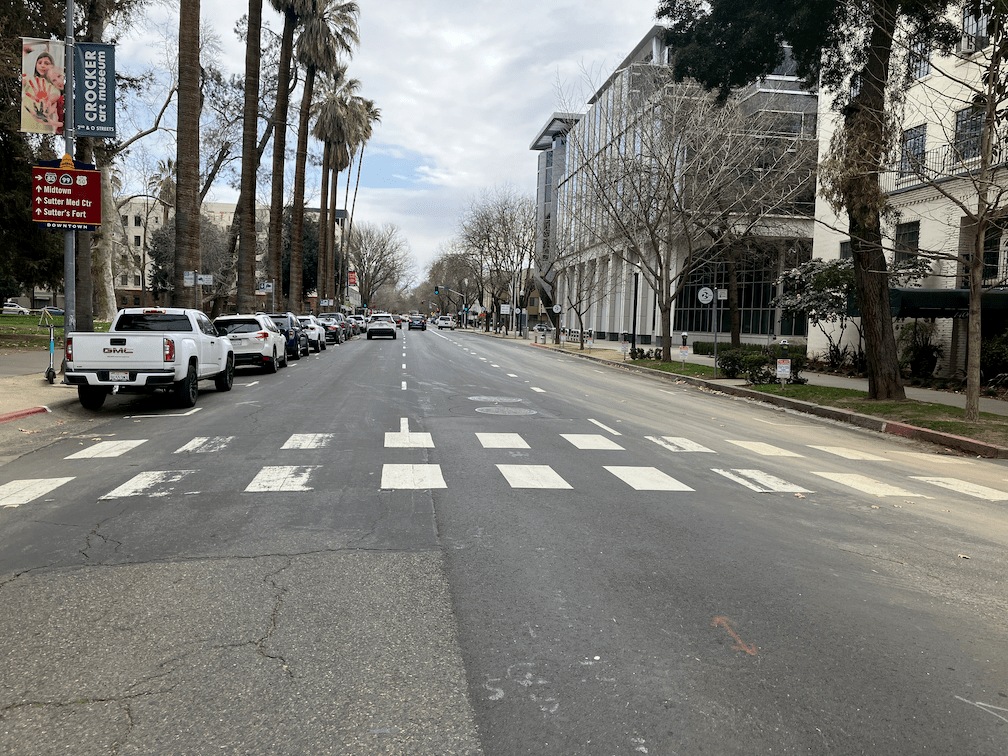
The gallery of photos below was taken today, admittedly mid-day when there is almost no traffic at all, but ‘rush hour’ would not look much different. Motor vehicle traffic has come back to pre-pandemic levels on some city streets, but has not on N Street, and it is very unlikely that it ever will.
How should N Street right-of-way be reallocated? By installation of a parking protected separated bikeway on the north (left) side of the street, from 3rd Street to 15th Street. Separated bikeway is the official term, though protected bike lane or cycletrack are common alternative terms. Though in general left side or right side each have advantages and disadvantages, in this case left side (north side) works best because the of long stretch free of driveways on the Capitol Park side, from 10th Street to 15th Street.
Sacramento already has parking protected separated bikeways on P Street, Q Street, 10th Street, and J Street, though J Street in particular is a weak implementation. The NACTO diagram shows a high quality parking protected separated bikeway with a concrete curb, which retains all the benefits and safety even when there are no parked cars. For sections with driveways, protection with vertical delineators may be appropriate.
NACTO diagram one-way cycletrack with curb
The number of driveways in each block between intersections is:
3rd-4th: one, parking garage
4th-5th: zero
5th-7th: two, parking garage, gated driveway
7th-8th: zero
8th-9th: one
9th-10th: two, rarely used
10th-15th: none
The advantages of this reallocation:
greatly reduces conflict between walkers and bicyclists on the north sidewalk between 8th St and 15th St
provides a safe east-west bicycle route
reallocates unneeded roadway width from motor vehicles to bicyclists
The city’s Central City Mobility Project will add 62 blocks of separated bikeways to the downtown area. All of these projects are great. But N Street is not among them. The lane reduction on I St, shown in purple, is particularly great. N Street would benefit from the same. Lane reductions not only slow motor vehicle traffic, but can shorten crossing distances for people walking. Three (or more) lanes in a direction are never safe, and never appropriate in an urban area. All of the three lane roadways in the city should be reallocated to other uses, and reduced to two lanes.
These type of projects are often called road diets, but I don’t like that term. The road is not on a diet, it is just being reallocated from unnecessary or unwanted motor vehicle capacity to more useful purposes such as walking, bicycling, or dining.
I was at a meeting last evening with transportation advocates when the subject of the turn left from Carlson Drive to H Street came up. Most people expressed discomfort about this turn, and most of the people were also experienced and skilled bicyclists. They felt that left turning motor vehicles, which go at the same time as left turning bicyclists, would encroach on the dashed green lane and hit bicyclists. They were also uncomfortable turning across the straight through lane, as they had seen people run this red light. This is a critical intersection and area for bicyclists, as it is one of four main routes onto and off the Sacramento State campus for bicyclists.
So far as I know, this was the first use of green paint, and the first use of a bicycle signal head in the city. The installation was intended to be innovative, and it was, for its time, in Sacramento, but it hasn’t stood up to the test of time.
Here is what it looks like from above. As you can see, it is a complicated intersection with several features intended to ease and speed motor vehicles. The city attempted to make the intersection safer without really changing it at all, beyond the green paint. Green paint helps communicate, but it does not protect in any way, and it has no legal meaning under California Vehicle Code or city code.
Carlson Dr – H St intersection aerial
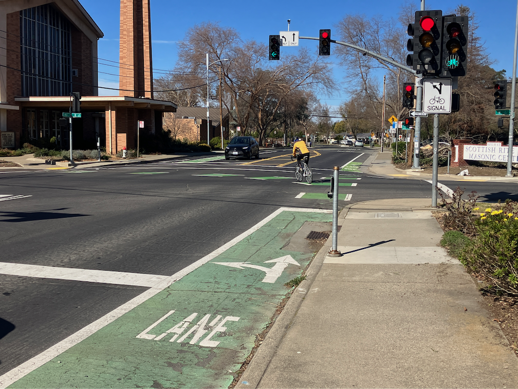
The two photos below show the setting of the left turn. The bicycle lane on the right side of the street leads to a dashed (skip) green lane turning through the intersection. The bike lane stop line is somewhat in front of the motor vehicle stop line, and there is a button to trigger the bicycle signal. The bicycle signal face is mounted to the right of the motor vehicle signal face, and there are two, before the intersection and on the far side.
bicyclist pressing the button to trigger the bicycle signalbicyclist turning left from Carlson to H St; bicycle signal face green
I was there at a low traffic (motor vehicles and bicyclists) time of day and was unable to capture a bicyclist and motor vehicle adjacent to each other on the turn.
I have to say that I was not uncomfortable with the left hand turn. I’m a strong bicyclist and good at anticipating and mitigating for driver misbehavior. But I’m not the person bicycle facilities should be designed and built for. They need to be comfortable and legible (understandable) for any bicyclist, of any age and skill level, including Sac State students who seem to be the majority of the bicyclists here. This left turn is not.
There has been only one reported bicyclist injury crashes at this intersection since the green paint was put in (as of December 2020), and one in the 6-1/2 years before, so it is not a high injury intersection. But intersections like this discourage bicyclists, and so fewer people are willing to bicycle here. The poor quality of most of the access points to the Sac State campus probably in large part explains why the school has a much lower bicycling rate than most universities.
I don’t have a ready solution for fixing this intersection so that it is safe and comfortable (low stress) for bicyclists. But I do believe it is the city’s responsibility to study it, design a safe and welcoming intersection, and install it.
The City of Sacramento, that bastion of doing the least amount possible, has failed to notice that progressive cities in the US and worldwide are making changes to their environment to make is safer for people who walk and bicycle, and more efficient and welcoming for people outside of cars.
What the city is NOT doing, that it could:
Accept responsibility for maintaining sidewalks, as an integral part of the transportation network. The city continues to shirk its responsibility, spending funds on motor vehicle infrastructure instead of maintaining walker infrastructure.
Installing leading pedestrian intervals (LPIs) at every traffic signal in the city. The same eleven have been in place for years; none have been added. The recent legislation, AB 2264, only applies to state highways; it is up to cities and counties to implement on other roadways.
Daylighting intersections. This means removing parking from within 15-20 feet of the crosswalk or stop bar, either by painting and enforcing red curbs, or building curb extensions (bulb-outs) at every intersection. Upstream, approaching the intersection, is the big safety feature, downstream, leaving the intersection is much less important. There are interim solutions here, such as painting curb extensions and using soft-hit posts (vertical delineators).
Implementing construction zone requirements that accommodate walkers and bicyclists. The current city policy is to provide safe bypasses only if it does not in any way inconvenience drivers. The public has asked that a policy be developed along the lines of the Oakland construction policy, but the city has stonewalled against that.
Making transportation improvements that benefit walkers and bicyclists, except with county, state or federal grants. The city simply will not spend any of its general funds on improving transportation safety.
Waiting until a roadway is completely repaved to reallocate roadway width to bicycle lanes or separated bikeways, or transit. Compounding this issue is that the city doesn’t share with the public the repaving projects that it intends to do, so the public has no chance to comment beforehand.
Lowering speed limits citywide. While it is true that spot reductions have little effect on travel speeds, there are a growing number of cities that have lowered speed limits citywide, with a significant reduction in speed.
Enforce traffic laws. The Sacramento Police Department has essentially stopped enforcing laws related to the safety of walkers and bicyclists. This of course is also true in many other places. Police don’t see traffic safety as an issue worthy of concern. Of course so much of law enforcement is used as pretext to oppress, and I’m not in favor of any of that, but if the police won’t even enforce failure to yield to people in the crosswalk, what use are they? We would all be much safer if traffic law enforcement were removed from the police, largely automated, and the money saved diverted to real community needs. Yes, defund the police.
Painting marked crosswalks at every intersection. Yes, I know that unmarked crosswalks are legal crossings, but most drivers either don’t know or don’t care, so marking crosswalks is critical.
Remove beg buttons. These buttons, which sometimes a walker must press to get a walk sign, and sometimes don’t need to press (this is called auto-recall) are a direct attempt to discriminate against people walking. The city, after much pressure from the public at the beginning of the pandemic, set five crossings to auto-recall, out of the thousands. Of course they didn’t change the signing, so people walking don’t know this. The city it being intentionally obstinate in its defense of this outmoded requirement.
Remove pedestrian prohibition signs unless that is a demonstrable safety reason for the prohibition. There are numerous signs all over the city that were placed solely to preference motor vehicle drivers over people walking. The default should be that every one is removed unless the city wishes to do a traffic study to justify them.
Install traffic diverters (mode filters) all over the city. These diverters, which allow bicyclists free travel but turn motor vehicle drivers aside, are the single most effective safety measure that city could implement. But the city has decided to take these off the menu of solutions, for no reason that it has ever been made public. The few that exist are in the central city, almost none in other neighborhoods. Another example of privileging the already privileged over lower income neighborhoods.
Charge for parking, eveCavrywhere. Residential neighborhoods, where there is usually open parking space, would be charged through permits for the cost of maintaining that portion of the street. Any place where parking is in short supply, market rates for parking should be charged. Giving away free parking is subsidizing drivers and throwing your tax money in the trash.
I could go on with this list for pages. In fact, I have: walking policies for SacCity, and many related posts. But the city is still not taking meaningful action on any of these items, so I will keep reposting. For as long as it takes. And it will probably take quite some while before the city gets over its culture of doing the least amount possible.
Caveat: The city has disinvested in lower income and high minority neighborhoods, probably for its entire history. The first steps should be taken in these neighborhoods, with input from the residents, of course, and not in higher income and non-minority neighborhoods which have always gotten more than their share.
My last three posts have been about locations where sharrows replace bike lanes for one-block sections in the Sacramento central city: Sacramento’s worst possible place for sharrows; Sac kill those sharrows on I St; Sac kill those sharrows on H St. There may well be other such locations that did not come to mind. If so, please let me know so I can document and post on them. I’m not asking about locations that should have bike lanes, or where bike lanes should be upgraded to separated (protected) bikeways. There are simply too many of those locations for me to deal with.
So, why are bike lane gaps so important? Bike lanes are basically a promise to bicyclists that the city is providing a safe place to ride your bike. Yes, I know traditional bike lanes have serious safety issues (they are called door zone bike lanes, or DZBLs), but for the average rider, they are safer than no bike lane. But this promise is broken when there is a gap. For these gap sections, bicyclists who felt comfortable riding in a bike lane are suddenly left to deal with motor vehicle traffic in a location where neither the bicyclist nor drivers are sure how to behave. What does the average bicyclist then do? Decide never to ride on that street again. And if they have a scary experience, they may even decide not to ride again at all.
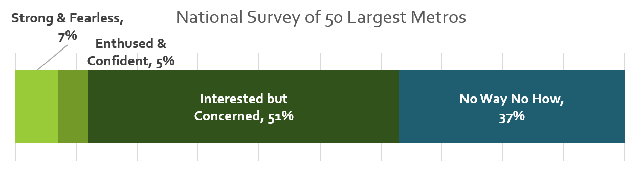
I’m a bicyclist with strong vehicular bicycling skills. I know where the safest place to ride is on every street, and I ride there no matter what motor vehicle drivers or law enforcement happens to think about it. But I am far, far from a typical Sacramento bicyclist. I am ‘strong and fearless’, though as I get older, I’m tending towards ‘enthused and confident’. The four types of bicyclists, or levels of comfort, developed in Portland but applicable to Sacramento, are shown in the graphic:
The city should be designing bicycle facilities that work for all three categories of people who will bicycle. When there is a gap in a bike lane, the city has designed bicycle facilities that serve the ‘strong and fearless’, only 7% of potential bike riders. This is discriminatory. It is wrong. I suspect that with the resurgence of bicycling and the availability of e-bikes, the ‘no way, no how’ category has shrunk a bit.
The city must close bike lane gaps. Not off in the future when the street is repaved, or when a grant is obtained, but NOW. To do otherwise is to intentionally discourage bicycling and to risk people’s lives.