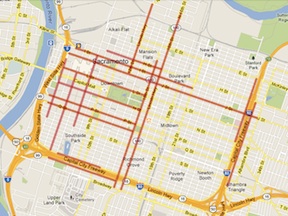
At right is a map of the 3-lane (or more) streets in the downtown/midtown section of Sacramento. All of these streets are also one-way streets. Many people call this the grid, but others define the grid as a larger area including areas east of Alhambra Blvd and south of Broadway. This map was created using Google maps and memory, and has not yet been field checked.
These streets total about 25.4 miles.
The map graphic links to the map data in Google Maps, from which you can zoom in on areas and turn on or off satellite view.
The map provides background for an upcoming post about transforming transportation and livability in downtown/midtown.

[…] two-lane streets. The map showing these streets in the downtown/midtown area is linked from my Sac 3-lane Streets […]
LikeLike
[…] 3-lane streets in downtown/midtown Sacramento […]
LikeLike