There are a few streets in Sacramento which are wide enough to host many activities and modes of travel, with reallocation of the roadway width to meet a new vision of a livable, walkable city. Two NACTO diagrams are below. The first, a downtown one-way street, is interesting to me because it shows a better use of space without having to change from one-way to two-way. I have always been opposed to one-way multiple lane streets because they present the multi-lane threat to people crossing the street, when one driver stops but others do not. This is one of the most common causes of fatalities for walkers, and why it must be eliminated. However, if the design is changed, the street becomes much safer, and the multi-lane threat is reduced or eliminated. Check the NACTO page for an alternate design.
NACTO downtown one-way street
I believe there should be high frequency bus service on J Street from 5th St to the university, and if J Street remains one-way, paired service on L St. This diagram would be a great model. Current service is 15-minute frequency on part of the route, but only 30-minute on part. Service should be at least 10-minute, maybe even more frequent. This would be a good design for that service and for those streets. Yes, L Street is not continuous, due to a broken street grid, so either H Street or Folsom Blvd could be used to connect.
Other streets that might remain one-way, but only with redesign, include the 9th-10th couplet, 15th-16th couplet, 19th-21st couplet, and P-Q couplet. The W-X couplet that bounds the Hwy 50 freeway would have to remain one-way due to freeway onramps and off ramps, but must be narrowed significantly. It is nothing but a traffic sewer as currently designed, and the motor vehicle capacity of the street is completely unneeded, even during rush hours.
I am working on a project to find some of the land in the central city that could be housing instead of empty land, or surface parking lots. To me, every surface parking lot is a crime against the climate because it spreads out housing and other amenities to the point where driving becomes preferred if not necessary. But while comparing the county parcel map to the current land use, I was struck by what a sad, sad loss of housing there has been, particularly in the downtown section of the central city. To highlight this, I picked a block very close to where I live, the block bounded by P Street, Q Street, 11th Street, and 12th Street. On this entire block, there is one temporary building, a state child care center, and a small power facility related to the SacRT light rail tracks on 12th Street.
The image below shows the county parcels, labeled with addresses, overlaid on up-to-date ESRI Imagery layer. The child care building is in the lower right corner, at the intersection of 12th Street and P Street, and the SacRT facility is on the unlabeled square on 12th Street. The entire remainder of the block is parking. Some of the parking is state-owned, some privately owned. Every single one of these parcels at one time had either housing or business, or both, though there is some indication that the northwest corner large lot may have been a gas station for a period of time.
Sacramento parcels overlaid on imagery, P Street to Q Street, and 11th Street to 12th Street
I first looked at Google Earth historical imagery, but the only fact from that is that in 1993 all of the block had been converted to parking, and the child care center was probably there (the photo is fuzzy). Then I looked through Center for Sacramento History photos. I have only started through the archive, but did find some photos of the block or nearby blocks. One things that surprised me is that in the early 1950s homes were already being torn down to build state buildings. The photo below shows 1116, 1118, and 1124 P Street in 1949. If I’m able to get a better image, I will replace this one. It shows what seems to be typical of housing in this area, single-family and multi-family mixed in.
The Sacramento Redevelopment Agency was established by 1951, and its mission was to remove all housing that didn’t meet its standards, which meant all housing occupied by lower income and people of color, centering on Japantown.
CADA (Capitol Area Development Authority) was established in 1978 to save what little was left of housing in downtown, so it is probable that the housing had been torn down by the state or city well prior to that. If so, that means that this block has been a parking lot for at least 43 years. Probably much longer, perhaps back into the 1950s. What used to be homes and businesses, has been essentially worthless for that entire time. So, so sad.
For more info on the destruction of downtown, I recommend any books by local author Bill Burg (in local bookstores for paper copies or on Amazon for Kindle copies). You can also find a number of papers and research documents on the Internet by searching ‘Sacramento redevelopment’. I have hardly scratched the surface.
There are several entire blocks of parking in downtown, and many, many blocks that are mostly parking. What a waste!
I ask that the state transfer all surface parking lots under its control to CADA. The state has as many office buildings as it will ever need, but there is no housing to support the office workers, and particularly the lower income maintenance workers that support these office buildings. More to come on that idea.
I welcome historians, particularly Bill Burg, to correct or amplify my information.
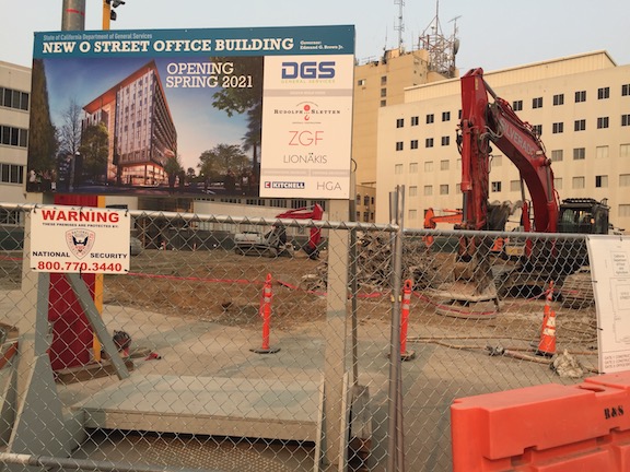
The state is building several new office buildings downtown. Close to where I live, the former building at O St and 12th is gone, and will be replaced with a modern office building, and the block between O and P and 7th and 8th is seeing a new building. There are others planned, and there is a plethora of state-owned surface parking lots (a travesty of land use if ever there was one) that could be developed.
It is good, in a sense, to see the state aggregating scattered offices into more centralized locations. But what is not good is that the state is not building any housing to go with the offices. So most employees will still be driving in from the suburbs, creating air pollution and rush hour congestion in the process, while contributing nothing to life in the central city. Almost every new building, whether public or private, has some retail, at least a corner and sometimes the whole ground floor. But integrated housing and office is rare.
So, my modest proposal (in the Swiftian sense) is that every office building of one-quarter block or larger include housing for at least one-quarter of the employees of the building. Not just the daytime office drones, but the maintenance staff as well. Some percentage should be required affordable, probably 20% to cover the lower income maintenance and clerical staff. I am not saying the the residences should be limited to employees of the building, I’d leave it up to each building manager how they wanted to allocate housing.
I have mixed feelings about whether this should be required of private developments. Certainly there should be codes and city support for accomplishing the same objective in private development, but requirements, not so sure. But state owned buildings, yes, absolutely, every one of them.
I lived in midtown, close to the downtown boarder, for seven years, and have now lived in downtown, near the midtown border, for just under a year. I moved all of five blocks. These two places might as well be in different cities. Downtown is dead, dead, dead at night and on weekends, whereas midtown is alive weekdays, evenings, and weekends. The difference? I think it is primarily the lack of housing in downtown. Office towers do not make for a livable, walkable place.
Several Sacramento area people have referenced the article “12 Strategies That Will Transform Your City’s Downtown” on the UrbanScale blog by John Karras. I’d like to look a little more closely at some of the strategies. If you have information or thoughts about any of these, please contribute.
#1 Turn one-way streets into two-way streets. Sacramento, and specifically downtown/midtown, has most of the one-way streets in the region. The city does have a policy to convert some of these streets, but the effort stalled, and no one seems to know why or be willing to admit why. Several streets have been resurfaced recently without being converted, though this would be the perfect time to do it. These include H, I, 9th, and 10th. There are some costs to conversion, turning signals around or installing new signals in some cases, the the reward in walkability and retail success is worth it. The post says “One-way streets are great if your only goal is to channel traffic through your downtown, but they are bad for pedestrian activity and retail opportunities. Two-way streets create a more comfortable pedestrian environment and have been shown to increase property values.” J Street in Sacramento is a classic example of how one-way streets reduce retail business. All those thousands of cars streaming by the most dense retail street in the region, and only small bubbles of successful retail to show for it. I’m glad Karras has this one on the top, because it is one of my strongest desires, with many blog posts: Two-waying streets in SF, New bike lanes, diets and sharrows downtown, street changes, more on conversion to two-way streets, and Choosing streets to walk.
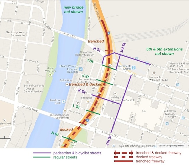
Interstate 5 is a Berlin Wall through the heart of Sacramento, severing the connections between downtown and Old Sacramento. It was a product of a time when cars ruled the world, and no other values were of importance. Those times are over, and now it is time to tear down the wall and re-unify Sacramento. A map showing the general idea follows the break, but here are the highlights:
the current Interstate 5 elevated freeway would be torn down, and replaced by a trenched and decked section
I Street, J Street, L Street, and N Street would be reconnected over the freeway as regular streets; K Street would be reconnected over (not under) the freeway as a pedestrian and bicyclist street, the main grand entrance to Old Sacramento for tourists and many locals
Old Sacramento would not only be easily accessible from downtown, but visible from downtown
other adjustments would be made to the streets and circulation in this area
This will certainly not be my last post on these ideas, and I will explore the why and how of the pedestrian and bicyclist streets shown.
Note on terms: “cut and cover” is often used for underground transit and rail lines, but the term seems less commonly used for freeways, so I’ve used “trench and deck”; “the big dig” is also often used, after the project in Boston, which went way over budget and took years longer than intended, but apparently has had a very positive affect on the city
Traffic circulation, for everyone, is handicapped or prevented by an incomplete grid system in downtown and midtown Sacramento. Three recent posts have addressed this issue, I’m thinking about several more, and several posts over the last year were also on the same topic. So I created a new category for the Getting Around Sacramento blog, re-gridding Sacramento.
Re-gridding is an awkward phrase, but I haven’t come up with a better one yet, so I’ll use it for now.
Note: I’ve updated this post to add some detail to the descriptions and photos to illustrate the treatments. I will be adding separate detailed posts on some of these treatments.
Following on my earlier posts about changing streets in downtown/midtown Sacramento, here are additional street changes that might be used in some places:
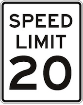
Reduce speed limit: Reduce speed limits throughout downtown/midtown to 20 mph. Of course simply reducing speed limits does not ensure that actual speeds go down, unless other measures are taken. The removal of three-lane and one-way streets will help a great deal, since these are the streets that most encourage speeding. Other changes suggested below will also slow traffic. I think, however, that the primary change will be a change in attitude, in cultural values. Once a place becomes more livable, people will focus more on being there instead of going through there to somewhere else. I see the whole pace of life in downtown/midtown as being slower, living at the pace of a walker, or even the pace of a casual conversation, rather than at the unnatural pace of a motor vehicle.
In my previous post, I suggested two major changes to the street grid in downtown/midtown Sacramento, one to eliminate one-way streets, and the second to convert all three-lane streets to two-lane streets. Of course there is an overlap between these changes, as all of the three-lane streets are also one-way streets.
The goal of these changes is to make it harder to commute to and from downtown Sacramento by car. Yes, that is my intention.
By way of explanation, I go back to Williams Burg’s documentation of the intentional de-population of downtown, and to a smaller degree, of midtown. There is an insufficient housing stock of all types in the downtown area, and in the midtown area there is a lack of some kinds of housing, primarily single family housing. I’m not talking here about separate housing, the suburban model of isolated houses on isolated lots in isolated communities, but of housing designed for families to live in that are not like apartments with shared facilities. Tapestri Square on 20th St is one example of this kind of single family housing, but there are many more both new and older. And of course there are Victorians still available which have not been subdivided into spaces too small for a family. Housing is gradually being added back into midtown. Where I live at 16th & O, there are two new mixed-use buildings going up, retail below and apartments above. There are others in midtown, and even a few in downtown.
The maps I posted the last two days were preliminary to this post. I would like to see two significant changes to the streets in downtown/midtown Sacramento that will make these areas more livable, more walkable, more bikeable, and safer. I am proposing the complete elimination of traffic sewers from downtown/midtown Sacramento. What is a traffic sewer? It is a street designed to move large volumes of vehicles at high speed in and out of work areas during morning and afternoon commute times. In Sacramento, the main work area is the state buildings downtown, though there are certainly other employers and other areas, including midtown.
3 to 2 conversion, 10th Street northbound
1. Convert all three-lane streets into two-lane streets. The map showing these streets in the downtown/midtown area is linked from my Sac 3-lane Streets post.
These three-lane streets are, of course, also one-way streets. In many cases the lane removed would be used to provide bike lanes or protected bikeways, but in some cases the space might be best used to create wider sidewalks or diagonal parking where additional parking is needed. Though in some cities the three-lane to two-lane conversion is used to create a turning lane, I don’t believe that these are necessary in downtown/midtown, nor do I feel that this is a good investment of right-of-way.
This conversion would remove some traffic capacity, though unfortunately, not as much as one might wish. Studies show only a slight reduction in capacity from this treatment, which is sometimes referred to as a road diet, though I like the term rightsizing.Read More »
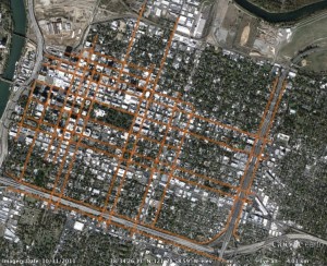
At right is the second map of downtown/midtown Sacramento, showing the 1-way streets. This map was created using Google maps and memory, and has not yet been field checked.
These streets total about 32.6 miles.
The map graphic links to the map data in Google Maps, from which you can zoom in on areas and turn on or off satellite view. The reason that this is not a map view graphic is that the online browser version of Google Maps starts paging after about 18 entries, so it is not possible to view all of the segments at the same time. This image is instead from Google Earth, via KML export and import.
The map provides background for an upcoming post about transforming transportation and livability in downtown/midtown.


 Reduce speed limit: Reduce speed limits throughout downtown/midtown to 20 mph. Of course simply reducing speed limits does not ensure that actual speeds go down, unless other measures are taken. The removal of three-lane and one-way streets will help a great deal, since these are the streets that most encourage speeding. Other changes suggested below will also slow traffic. I think, however, that the primary change will be a change in attitude, in cultural values. Once a place becomes more livable, people will focus more on being there instead of going through there to somewhere else. I see the whole pace of life in downtown/midtown as being slower, living at the pace of a walker, or even the pace of a casual conversation, rather than at the unnatural pace of a motor vehicle.
 In my
In my