I am working on a project to find some of the land in the central city that could be housing instead of empty land, or surface parking lots. To me, every surface parking lot is a crime against the climate because it spreads out housing and other amenities to the point where driving becomes preferred if not necessary. But while comparing the county parcel map to the current land use, I was struck by what a sad, sad loss of housing there has been, particularly in the downtown section of the central city. To highlight this, I picked a block very close to where I live, the block bounded by P Street, Q Street, 11th Street, and 12th Street. On this entire block, there is one temporary building, a state child care center, and a small power facility related to the SacRT light rail tracks on 12th Street.
The image below shows the county parcels, labeled with addresses, overlaid on up-to-date ESRI Imagery layer. The child care building is in the lower right corner, at the intersection of 12th Street and P Street, and the SacRT facility is on the unlabeled square on 12th Street. The entire remainder of the block is parking. Some of the parking is state-owned, some privately owned. Every single one of these parcels at one time had either housing or business, or both, though there is some indication that the northwest corner large lot may have been a gas station for a period of time.

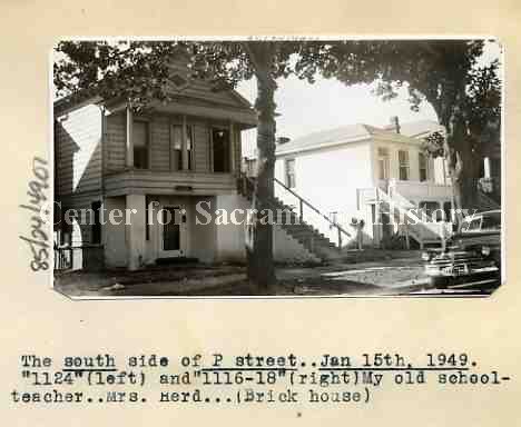
I first looked at Google Earth historical imagery, but the only fact from that is that in 1993 all of the block had been converted to parking, and the child care center was probably there (the photo is fuzzy). Then I looked through Center for Sacramento History photos. I have only started through the archive, but did find some photos of the block or nearby blocks. One things that surprised me is that in the early 1950s homes were already being torn down to build state buildings. The photo below shows 1116, 1118, and 1124 P Street in 1949. If I’m able to get a better image, I will replace this one. It shows what seems to be typical of housing in this area, single-family and multi-family mixed in.

The Sacramento Redevelopment Agency was established by 1951, and its mission was to remove all housing that didn’t meet its standards, which meant all housing occupied by lower income and people of color, centering on Japantown.
CADA (Capitol Area Development Authority) was established in 1978 to save what little was left of housing in downtown, so it is probable that the housing had been torn down by the state or city well prior to that. If so, that means that this block has been a parking lot for at least 43 years. Probably much longer, perhaps back into the 1950s. What used to be homes and businesses, has been essentially worthless for that entire time. So, so sad.
For more info on the destruction of downtown, I recommend any books by local author Bill Burg (in local bookstores for paper copies or on Amazon for Kindle copies). You can also find a number of papers and research documents on the Internet by searching ‘Sacramento redevelopment’. I have hardly scratched the surface.
There are several entire blocks of parking in downtown, and many, many blocks that are mostly parking. What a waste!
I ask that the state transfer all surface parking lots under its control to CADA. The state has as many office buildings as it will ever need, but there is no housing to support the office workers, and particularly the lower income maintenance workers that support these office buildings. More to come on that idea.
I welcome historians, particularly Bill Burg, to correct or amplify my information.
Hi Dan,
I’m a historian and I do lots of land use history research. You might try Sanborn Maps, historicaerials.com, and https://mil.library.ucsb.edu/ap_indexes/FrameFinder/
Btw, thanks for the blog. As a bicyclist, I appreciate what you do.
-Mel Melvin
LikeLike
[…] Getting Around Sacramento Blog – parking instead of housing. […]
LikeLike