Interstate 5 is a Berlin Wall through the heart of Sacramento, severing the connections between downtown and Old Sacramento. It was a product of a time when cars ruled the world, and no other values were of importance. Those times are over, and now it is time to tear down the wall and re-unify Sacramento. A map showing the general idea follows the break, but here are the highlights:
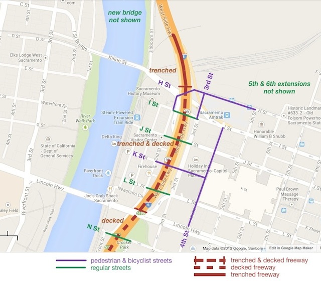
- the current Interstate 5 elevated freeway would be torn down, and replaced by a trenched and decked section
- I Street, J Street, L Street, and N Street would be reconnected over the freeway as regular streets; K Street would be reconnected over (not under) the freeway as a pedestrian and bicyclist street, the main grand entrance to Old Sacramento for tourists and many locals
- Old Sacramento would not only be easily accessible from downtown, but visible from downtown
- other adjustments would be made to the streets and circulation in this area
This will certainly not be my last post on these ideas, and I will explore the why and how of the pedestrian and bicyclist streets shown.
Note on terms: “cut and cover” is often used for underground transit and rail lines, but the term seems less commonly used for freeways, so I’ve used “trench and deck”; “the big dig” is also often used, after the project in Boston, which went way over budget and took years longer than intended, but apparently has had a very positive affect on the city

Existing Conditions and Proposals
South of Capitol Mall, the freeway is already trenched, but there is only one street crossing, O Street. The city has a funded project to improve O Street and Capitol Mall, but the project to create a new bridge for N Street is not funded, and the city has apparently given up on the original plan to deck the freeway between O Street and Capitol Mall. R Street is a pedestrian and bicyclist access point, on the old railroad bridge.
My proposal for this section is to again consider decking of the freeway. Decking is expensive, particularly for the wide expanse of lanes, but the value of a reconnected streets grid and developable land is very valuable.
North of Capitol Mall, the freeway climbs to an elevated level, in fact super-elevated so that various on and off ramps can fit underneath it, and continues this way until north of Richards Blvd. Neither the city nor Caltrans has any plans for changing or improving this section, so far as I know.
My proposal is to trench and then deck Interstate 5 from Capitol Mall to north of the main railroad tracks in the railyards area. With the freeway below ground, the surface would then be open for reconnecting the street grid and developing the land. Tear down of the existing freeway, then trenching, then decking over, would be very expensive. But again, not expensive compared to the value to be gained.
The decking of the entire section between O Street and I Street would create six square blocks of developable property. I imagine that some of this would be set aside a park or public plaza space, but most of it would be available for development.
North of I Street, the freeway would be trenched in order to go under the railroad tracks, but it need not be decked. Between the tracks and Richards Blvd the freeway could come back up to elevation. The location and configuration of the new bridge over the Sacramento River, probably connecting C Street in West Sacramento with Railyards Blvd in Sacramento, could affect where and how the freeway comes up again.
How to pay for it?
Most people will react that this is simply too expensive to even consider. I am not claiming that it will be other than very expensive. But I think the opportunity cost of leaving Old Sacramento severed from downtown, not only inaccessible but invisible, is very high. And the opportunity cost of leaving what should be developable land devoted solely to freeway is also very high. The return on investment of development is not too hard to quantify, and it is always positive so long as the development is well planned and doesn’t depend on subsidies to be successful. The return on investment of freeways is much harder to quantify, but I’d suggest that it is almost always negative. The cost of the freeway is not paid back by economic activity, and I’d even suggest that it is negative, because it encourages sprawl development which is always a negative economic activity, highly subsidized in order to be successful. And by encouraging people to spend a high percentage of their income on transportation and to lose the opportunity cost of time spent commuting, it encourages individuals and families to make poor economic decisions. But, still, the project will be expensive.
Here is how I’d allocate the cost:
- Caltrans would pay for all the teardown, trenching and decking. Caltrans created the problem, and Caltrans should solve the problem. Given the housing, economic and livability loss they inflicted on Sacramento, the agency would actually be getting off quite easy by only having to cover these costs.
- The City of Sacramento should pay all surface costs such as new streets, utilities, preparing land for development, and whatever park or public plaza space seems to be needed. The value of the land made available for development would easily be earned back by selling either parcels or development rights to private developers. I’m thinking that most of the development would be mixed use, including but not limited to arts and culture venues. We don’t really need any more government office buildings in Sacramento, and I’d hope that none of this land be used for that. Of course Sacramento is not, at this moment, short on developable properties, so the return on investment would occur over time and not when the infrastructure needs to be put in. It would be an investment.
Some Issues
- How wide does the freeway need to be? I’ve already suggested in and the freeways that the only reason that the freeway here is 10 lanes wide is to handle commuter traffic, which occurs only a few hours a week. The freeway only needs to be 4 lanes wide, in order to handle long distance commercial traffic and some local traffic. On and off ramps would add some width in places, but on the whole the footprint of the freeway can be much smaller than it is. And therefore much less expensive to trench and deck. An narrower trench also expands the types of development that could occur on top of the deck.
- What should be done with one-way streets? This proposal would both allow and encourage the conversion of all one-way streets in the downtown area to two-way streets, further supporting circulation and calming traffic. However, the proposal can work even if the streets are not converted, or if they are gradually converted over time.
- Where would on-ramps and off-ramps be located, and how would they change?
- northbound off-ramps (exits)
- Q Street off-ramp northbound: no change necessary
- J Street off-ramp northbound: would need to be revised, perhaps coming up directly onto J Street at about 4th Street. Or perhaps it would be better to two lower volume exits, one at N Street and the other at J Street.
- Richards Blvd off-ramp northbound: no change necessary
- northbound on-ramps (entrances)
- P Street on-ramp northbound: no change necessary
- L Street on-ramp northbound: would of course change to meet the trenched freeway
- I Street on-ramp northbound: Should be removed, and the city has already given some thought to this.
- If another northbound entrance north of L Street is needed, it could be from Railyards Blvd, making a better connection with the new bridge over the river.
- southbound off-ramps (exits)
- Richards Blvd off-ramp southbound: no change necessary
- J Street off-ramp southbound: Would need to be revised, to meet the trenched freeway. It is less clear to me what the solution here is. The historical buildings in Old Sacramento must not be impinged on. This might be one location where some of the new surface terrain would have to be given over to a ramp exit up to J Street where the current west edge of the freeway sits.
- Q Street off-ramp southbound: no change necessary
- southbound on-ramps (entrances)
- Richards Blvd on-ramp southbound: no change necessary
- I Street on-ramp southbound: Would have to be revised in order to match the trench. Again, I am not sure how to be handle this other than creating a left turn to onramp from the west edge of the existing footprint of the freeway, again sacrificing some developable land but staying clear of the historical buildings.
- P Street on-ramp southbound: no change necessary
- northbound off-ramps (exits)

Where will all the traffic go?
LikeLike
I love this idea.
LikeLike