diagonal parking

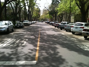
I’ve suggested using up excess street width with diagonal parking. Below are two photos of 17th Street in midtown, one of the section between N and O, which has parallel parking, and a much-too-wide street width. The second is between O and P, which has diagonal parking on the west side. Since these are right next to where I live, I get a regular chance to observe the behavior of drivers on these two sections. On the parallel parking section, drivers are almost always moving above the speed limit, about 30 mph, particularly since most of them have come from an overly-wide section of 17th north of N Street. On the diagonal parking section, drivers are almost always moving at less that the speed limit, about 20 mph. A more subtle difference is that northbound drivers, from the diagonal parking section, seems more willing to yield to pedestrians at the unmarked crosswalks at the intersection of 17th and O streets, whereas southbound drivers, from the parallel parking section, seems to be less willing to yield. Narrowing streets with diagonal parking really does make a difference!

17th St parallel parking
17th Street parallel parking
17th Street diagonal parking

more on conversion to two-way streets

A friend suggested that my streets change ideas were hardly new, and that is quite true. Some streets were converted in the past, some were identified for conversion but not completed, and many more have been suggested but not adopted by the city. Here are some additional references.

Some news articles about past and planned conversions in Sacramento:

References on past and planned conversions in Sacramento:

Articles and references on the one-way to two-conversion concept:

Note: There are a number of contrarian views available from the cars-first crowd. You can search for the Internet for “two-way conversion” if you want to find them.

additional street changes

Note: I’ve updated this post to add some detail to the descriptions and photos to illustrate the treatments. I will be adding separate detailed posts on some of these treatments.

Following on my earlier posts about changing streets in downtown/midtown Sacramento, here are additional street changes that might be used in some places:

  • r2-1_20Reduce speed limit: Reduce speed limits throughout downtown/midtown to 20 mph. Of course simply reducing speed limits does not ensure that actual speeds go down, unless other measures are taken. The removal of three-lane and one-way streets will help a great deal, since these are the streets that most encourage speeding. Other changes suggested below will also slow traffic. I think, however, that the primary change will be a change in attitude, in cultural values. Once a place becomes more livable, people will focus more on being there instead of going through there to somewhere else. I see the whole pace of life in downtown/midtown as being slower, living at the pace of a walker, or even the pace of a casual conversation, rather than at the unnatural pace of a motor vehicle.

Read More »

less commuting, more livability

Q-St-10th-St_SaratogaTownhomesIn my previous post, I suggested two major changes to the street grid in downtown/midtown Sacramento, one to eliminate one-way streets, and the second to convert all three-lane streets to two-lane streets. Of course there is an overlap between these changes, as all of the three-lane streets are also one-way streets.

The goal of these changes is to make it harder to commute to and from downtown Sacramento by car. Yes, that is my intention.

By way of explanation, I go back to Williams Burg’s documentation of the intentional de-population of downtown, and to a smaller degree, of midtown. There is an insufficient housing stock of all types in the downtown area, and in the midtown area there is a lack of some kinds of housing, primarily single family housing. I’m not talking here about separate housing, the suburban model of isolated houses on isolated lots in isolated communities, but of housing designed for families to live in that are not like apartments with shared facilities. Tapestri Square on 20th St is one example of this kind of single family housing, but there are many more both new and older. And of course there are Victorians still available which have not been subdivided into spaces too small for a family.  Housing is gradually being added back into midtown. Where I live at 16th & O, there are two new mixed-use buildings going up, retail below and apartments above. There are others in midtown, and even a few in downtown.

Read More »

street changes

The maps I posted the last two days were preliminary to this post. I would like to see two significant changes to the streets in downtown/midtown Sacramento that will make these areas more livable, more walkable, more bikeable, and safer. I am proposing the complete elimination of traffic sewers from downtown/midtown Sacramento. What is a traffic sewer? It is a street designed to move large volumes of vehicles at high speed in and out of work areas during morning and afternoon commute times. In Sacramento, the main work area is the state buildings downtown, though there are certainly other employers and other areas, including midtown.

3 to 2 conversion, 10th Street northbound

1. Convert all three-lane streets into two-lane streets. The map showing these streets in the downtown/midtown area is linked from my Sac 3-lane Streets post.

These three-lane streets are, of course, also one-way streets. In many cases the lane removed would be used to provide bike lanes or protected bikeways, but in some cases the space might be best used to create wider sidewalks or diagonal parking where additional parking is needed. Though in some cities the three-lane to two-lane conversion is used to create a turning lane, I don’t believe that these are necessary in downtown/midtown, nor do I feel that this is a good investment of right-of-way.

This conversion would remove some traffic capacity, though unfortunately, not as much as one might wish. Studies show only a slight reduction in capacity from this treatment, which is sometimes referred to as a road diet, though I like the term rightsizing.Read More »

1-way streets in downtown/midtown Sacramento

1-way streets in downtown/midtown

At right is the second map of downtown/midtown Sacramento, showing the 1-way streets. This map was created using Google maps and memory, and has not yet been field checked.

These streets total about 32.6 miles.

The map graphic links to the map data in Google Maps, from which you can zoom in on areas and turn on or off satellite view. The reason that this is not a map view graphic is that the online browser version of Google Maps starts paging after about 18 entries, so it is not possible to view all of the segments at the same time. This image is instead from Google Earth, via KML export and import.

The map provides background for an upcoming post about transforming transportation and livability in downtown/midtown.

3-lane streets in downtown/midtown Sacramento

3-lane streets
3-lane streets

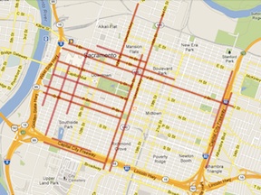
At right is a map of the 3-lane (or more) streets in the downtown/midtown section of Sacramento. All of these streets are also one-way streets. Many people call this the grid, but others define the grid as a larger area including areas east of Alhambra Blvd and south of Broadway. This map was created using Google maps and memory, and has not yet been field checked.

These streets total about 25.4 miles.

The map graphic links to the map data in Google Maps, from which you can zoom in on areas and turn on or off satellite view.

The map provides background for an upcoming post about transforming transportation and livability in downtown/midtown.

Sacramento transportation projects

This is the current list of Public Works transportation projects in the City of Sacramento. I know about a few of these projects, but many of them I don’t know anything about. It would be worth exploring all of them to see what the implications are for walkability and bikeability, but where would I find the time? Some projects have their own document or page on the city website, but most of them don’t, at least that I’ve been able to find, so I presume these would require getting in touch with the city to get the documents.

SacCivilProjects_2013-01

Cordova Hills on Tuesday

The Sacramento County Board of Supervisors will consider the Cordova Hills sprawl development again on this coming Tuesday, January 29. The issue is agenda item #44, which will not be considered before 2:00PM, but may be considered later if the meeting is behind schedule. I don’t know whether this will again be a marathon meeting going on for hours, but if you wish to comment or observe, it is better to be there on time.

On the request of Phil Serna, SACOG considered the Greenhouse Gas (GHG) implications of the development, with and without a university. You can read the full letter SACOG_MikeMcKeever-on-CordovaHills (1.6MB), but the summary statement on page one is enough:

Cordova Hills will face challenges being included in the next MTP/SCS (to be adopted spring, 2016) largely based on market feasibility considerations, with or without a University. Those challenges are greatest if it is not clear when the University is likely to be built.

On a per capita basis (the relevant performance metric for SB375) Cordova Hills will create higher transportation greenhouse gas emissions relative to other development opportunities in the region, with or without a University. Per capita emissions will be significantly greater without a University than with a University.

An updated Air Quality Mitigation Plan has been provided, with approval from the Sacramento Metropolitan Air Quality Management District, which reflects their midnight conversion to accept the project. The primary added mitigation is the reduction of natural gas combustion through the use of tankless water heaters. As I’ve said before, if it was so easy to achieve these reductions, why were they not included in the project to begin with? [If you want to look at this and other documents (there are now about 72), go to the agenda page and download them. Some are huge.]

There have been several letters and comments in the Sacramento area media since the last hearing, urging that the development be approved because we can trust that the developer will obtain a university. There is no evidence for this, but I guess if you have enough friends in high places, you can make such claims.

I remain absolutely opposed to this project. If we can stop this one, there is hope that there won’t be any more of these sprawl-inducing, urban-services-boundary-busting proposals, but if this one goes through, the floodgates are open and quality of life in Sacramento County for all of us is down the tubes.