update on SacCity ADA ramps

Note: I discovered that I have often used ‘detectible’, but should have been using ‘dectectable’ for detectable warning strips.

This is Central City Mobility Project update #2.

This is an update to the update on work being done on corner ADA ramps in the Sacramento central city, apparently as part of the Central City Mobility Project.

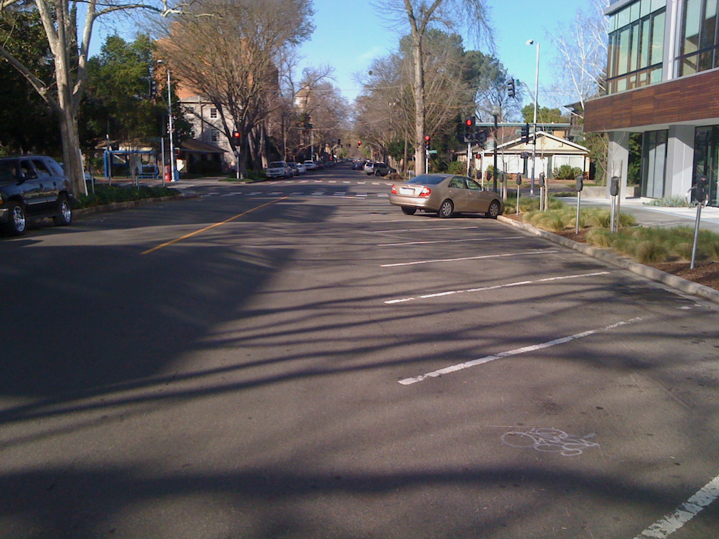
So far as I have seen, curb extensions are not part of this project.

There are now a number of locations where the concrete ramp is being cut so that the detectable warning strip can be installed, but the curbs are not being touched. See below for an example.

Q-St & 16th-St, SW corner, ADA ramp construction

One of the corners I have been monitoring, 21st St and O St northeast corner, is complete, but with temporary patches that make the ramps useable, though ironically still blocked by folding barricades and caution tape, which absolutely does not meet ADA guidelines for contruction signing and safety. This seems to be the pattern with the city, trying to make things better, but not paying attenteion to the details. I don’t know when the asphalt will be restored and the corner opened. Maybe the contractor is waiting until all the corners are ready before patching, though that would be stupid.

21st-St & O-St, NE corner, completed corner with ADA ramps

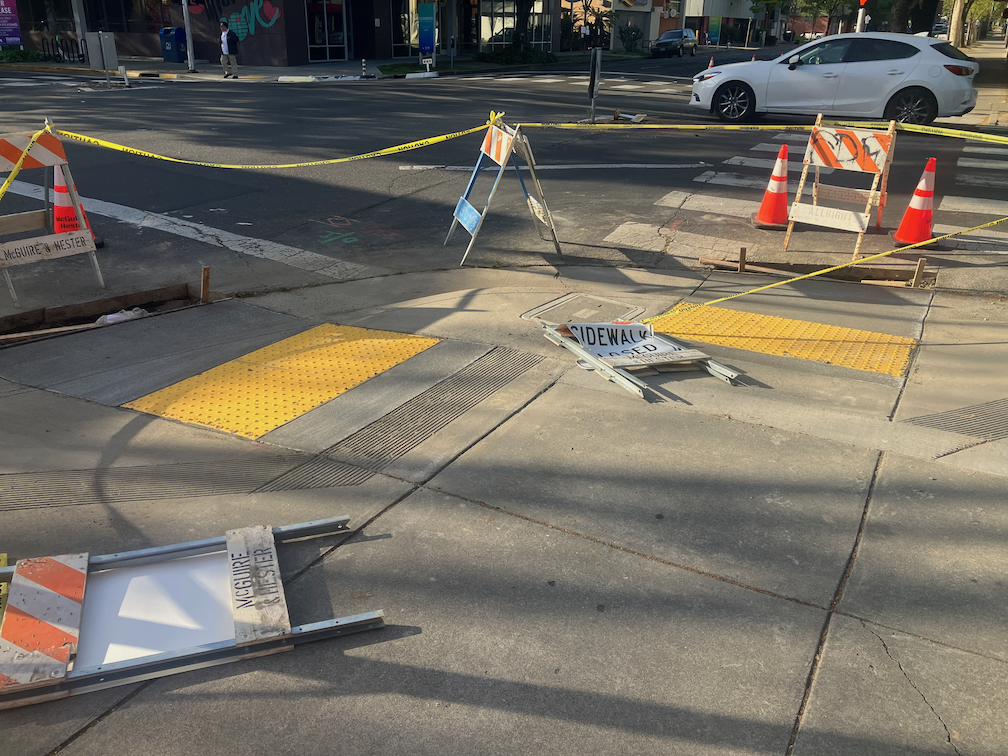
I am still not able to make sense of the asphalt cuts that are being done on the corners where the curb will be or has been modified. I’m guess that there was a standard cut design, implemented everywhere, no matter what the actual project.

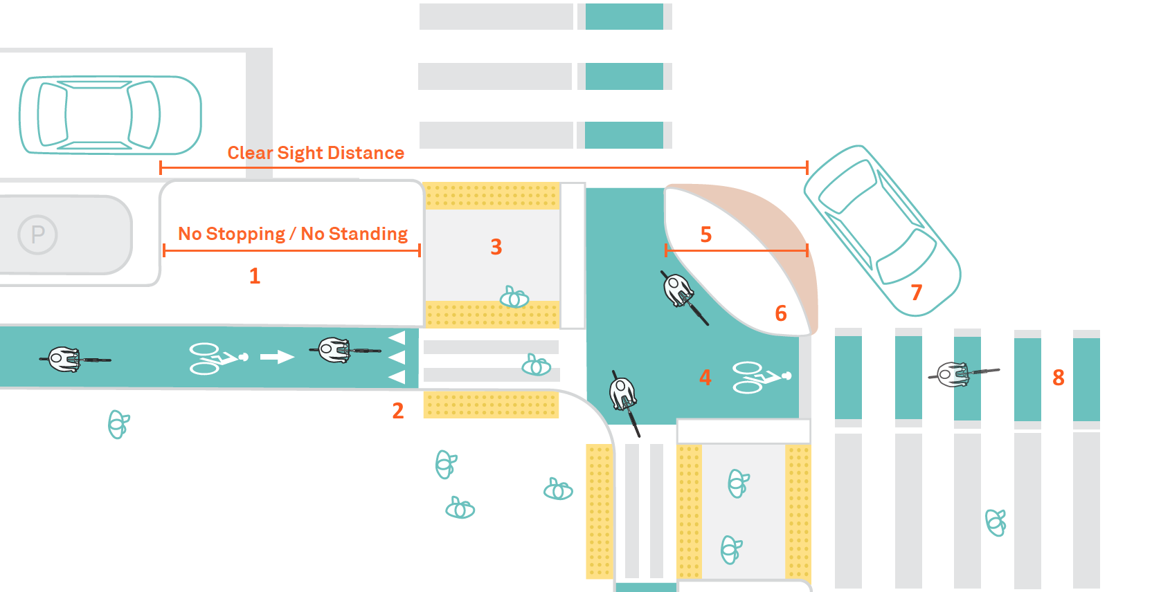
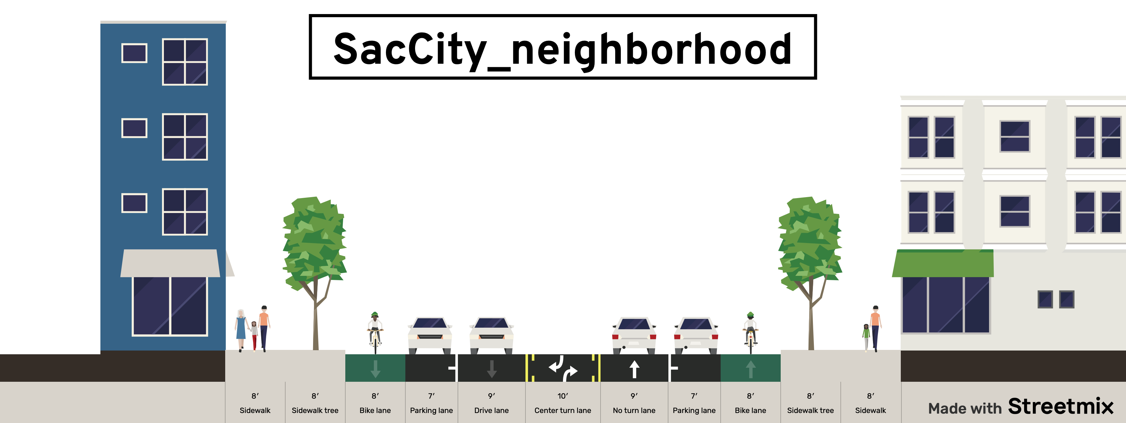
Walking around the central city, it appear that most of the corners which did not have ADA-compliant ramps will have them when the project is done, but some may not. I don’t know what the criteria is for which corners are being done, and which are being done at a higher level of replacing the curbs and widening the ramps. Many of the existing ramps are narrow, with edging curbs, which was apparently the design at the time they were placed, but the new corners are a different design, with a sloping area between the two ramps, similar to the diagram below, from the 2020 Department of Utilities Standard Specifications: Transportation drawings, not from the 2009 Department of Public Works Street Design Standards, which contain no ADA diagrams. I think the detectable warning strip width is at least 60 inches on the new installations, which is an improvement. The 48 inch width does not allow two people to stand on the strip. Corners with new curb extensions seem to have 72 inch strips.

SacCity T-76 Curb Ramp Dual Combination Planter diagram
SacCity_T-76_CurbRampDualCombinationPlanter

SacCity intersection design

Part of an ongoing series of posts to support better streets in the City of Sacramento during their 2023 update of Street Design Standards. New standards must be innovative, safe, and equitable, and it will take strong citizen involvement and advocacy to make them so.

This intersection design post follows on to the SacCity intersections of local streets post, addressing intersections of larger streets. See SacCity street classification for detail on types of streets (local, neighborhood, corridor).

The most important point of intersection design is that multi-lane roundabouts have absolutely no benefit for people walking or bicycling, particularly those with vision or mobility limitations. They are no more safe than regular intersections, and some research indicates they are less safe. They are just more motor vehicle infrastructure masquerading as something innovative and safe. If the city were to include a design for multi-lane roundabout, it would be a travesty.

This is also the last of the design detail posts. I realize that the posts have veered off into related issues, and the piecemeal nature of the posts makes it hard to see the overall pattern, so I will try for a summary post in the near future.

Policy

  • New or reconstructed intersections of neighborhood streets will generally use protected intersection design
  • New or reconstructed intersections of corridor streets will use prote
  • New and reconstructed intersections will include curb extensions, raised crosswalks or raised intersections, and/or protected intersection design
  • ADA ramps at intersections will always be perpendicular to the roadway, never diagonal
  • Daylighting for visibility will be provided at all intersections, through red curbs, curb extensions, or protected intersections; if red curbs alone are used, the offset from intersection should be at least 15 feet
  • Roundabouts: single-lane roundabouts will be considered for any reconstructed intersection except local streets; multi-lane roundabouts have no safety benefits and will be prohibited
  • Intersection corner radii will be set to ensure slow and safe turning speeds for all motor vehicles; truck and bus routes will never be more than 15 feet
  • Safe crosswalks will be provided at no less than every 1/8 mile in all urbanized areas; 30 mph, crosswalks must have at least pedestrian activated or automated flashing beacons; at 40 mph, crosswalks must have full signalization
  • Slip lanes will be removed from existing streets and not installed on new or reconstructed streets
  • Pedestrian crossing prohibitions will be removed from all intersections except those with freeway onramps and off ramps

Design diagrams will include:

  • ADA ramps, including design which prevents accumulation of water at the base of ramps
  • intersections of local streets
  • intersections of neighborhood streets with neighborhood streets or local streets
  • intersections of corridor streets with corridor streets, neighborhood streets, or local streets
  • protected intersections
  • modal filters/traffic diverters
  • single lane roundabouts
  • curb extensions (bulb-outs), with concrete curbs
  • interim curb extensions with paint/post installations

Two design diagrams for protected intersections, the first from NACTO Don’t Give Up on the Intersection: Protected Intersections, the second from Alta Design+Planning Evolution of the Protected Intersection, for protected intersections, followed by NCHRP Roundabouts: An Informational Guide, for a single-lane roundabout.

NACTO protected intersection diagram
NACTO ‘Don’t Give Up on the Intersection’ Protected Intersections diagram
Alta Design+Planning Evolution of the Protected Intersection
Alta Design+Planning ‘Evolution of the Protected Intersection’ diagram
NCHRP 'Roundabouts: An Informational Guide' diagram
NCHRP ‘Roundabouts: An Informational Guide’ diagram

update on half-measure corners

This is Central City Mobility Project update #1.

There has been construction on several of the corners I had previously mentioned (half-measure corners?), with 21st Street and O Street being the most advanced. It seems that I was wrong about curb islands being put in – there is no evidence of such construction. I don’t know why the asphalt cutting implied that. When more of these are complete, I’ll post again.

What seems to be going on is simple updates to place ADA-compliant curb ramp with detectable warning strips. Of course any improvement to curb ramps helps everyone, disabled and otherwise, and I’m not criticizing that. Rather, wondering why when the city is changing these corners, they did not take the opportunity to do true curb extensions. The ADA ramp and detectable warning in place for O Street is wider, than previous ramps and strips, looks to be more than four feet rather than the prior narrow ones. If all the ramps end up wider, that will be a plus.

This work is probably part of the city’s Central City Mobility Project. The project detail mentions ‘turn wedges’. Maybe the wedges will be added later, or maybe these will be at different locations than the ones I’ve looked at. The page does not specifically mention ADA ramp improvements.

21st St & O St, northeast corner, ADA ramp construction, partially complete

I had mentioned in the previous post curb extensions being extended to serve as bus boarding areas. I am not aware of any of these in Sacramento, but San Francisco has many. Many earlier posts have mentioned bus boarding islands, but this is for a street without bike lanes (yet), which allows the bus to stop in-lane and people to board directly. Notice that the extension allows for a bus shelter without constraining the sidewalk width for walkers. This should be the standard for Sacramento for all streets with bus routes but not bike lanes.

curb extension and bus boarding extension, San Francisco, Leavenworth & Sutter

half-measure corners?

Summary: The city should not install curb islands at corners, as it is currently doing, but rather install much safer and more effective true curb extensions, even if fewer can be installed now. Temporary installations can be used at other corners.

The City of Sacramento is currently re-doing a number of intersection corners in midtown. Most of these corners are along 21st Street, so far as I’ve noticed, but some are on other streets, and there well may be other locations I’ve not noticed yet. Last week crews were out saw cutting asphalt at corners, in preparation for new concrete work. The existing corner concrete and ramps have been removed from at least two corners, and at the 21St Street and O Street corner there is form work for whatever is going to replace the old corners.

The first photo is of the saw cuts at P Street & 19th Street. The cuts don’t really stand out, but they do indicate the areas that will be changed.

19th St & P St, SW corner, asphalt cuts for corners changes

It appears from the saw cuts that what is going to be constructed is something similar to the existing northwest and northeast corners. Northwest is shown below. I am not sure what to call these. They are not in the city’s street design standards, and almost the only place where I’ve seen them is Sacramento. I looked at several other cities to see if these were in their street designs, and they were not. So, just to call them something, I’m going to call them ‘curb islands’. The City of Los Angeles calls these floating curb extensions, but apparently their intended use is with bike lanes, not with gutters.

19th St & P St, northwest corner, corner islands
Read More »

SacCity street classification

Part of an ongoing series of posts to support better streets in the City of Sacramento during their 2023 update of Street Design Standards. New standards must be innovative, safe, and equitable, and it will take strong citizen involvement and advocacy to make them so.

After much thought, and feedback from other transportation advocates, I am finally ready to propose street classifications for the revision of the street design standards. I have written about street classification before: how to classify streets?; NACTO yield street; NACTO neighborhood main street; NACTO downtown streets.

I am offering only three street classifications. I know most classification systems use more, but I’m for simplicity. A key part of this classification scheme is that streets with more than two lanes per direction are NOT streets, and should be called roads instead. Of course they are stroads, but the city is unlikely to use that term. A road is for traveling, and therefore should have few to no driveways and few to no turning movements. Every driveway and ever turning movement is an invitation to conflict and crashes. The arterial roadways in the city fit into the stroad category. We don’t need them, and we should never construct another.

Street classification (see below for diagrams):

  • local or yield: narrow lane (unmarked), parking, up to 20 mph; for local travel
  • neighborhood: two lanes, regular bike lanes, up to 30 mph; for local and through travel
  • corridor: two to four lanes, bus lanes, separated bikeways, up to 40 mph; for local and through travel
  • traditional functional classification system (arterial, collector, local) will not be used; classification into residential, commercial, etc will not be used since all areas may be mixed use
  • new or reconstructed streets will not be designed for more than two lanes per direction

Policies

  • All one-way multiple lane streets should be considered for conversion to two-way streets
  • One-way single lane streets will be considered for narrow right-of-ways widths or where right-of-way is needed for other purposes
  • Streets which are repaved and re-striped (reallocated) but not reconstructed will include striping that increases safety and reduces speeds
  • Reconstructed streets will be designed for the level of VMT (vehicle miles traveled) or  ADT (average daily traffic) that is desired for safety, livability and economic vitality; the design or posted speed limit prior to reconstruction will not control in any way the new design
  • Design for reconstructed streets will consider the reduction or consolidation of driveways, and particularly of driveways that are too close to intersections
  • Driveway width for single family residences will be no more than 10 foot width; driveways for multi-family and commercial areas will be the minimum required by fire agency
  • Center turn lanes will be used only where frequent turning movements into or out of driveways are expected and accepted; they will not be used to fill excess roadway width
  • Speed humps or tables on a street generally indicates a failure to design for the desired speed, and will not be used on new or reconstructed streets, and only as a temporary solution on other streets
  • When streets are re-striped after repaving, but are not reconstructed, the excess lane width will be devoted to other uses or marked off as invalid travel areas
  • Designs will not include dedicated right hand turn lanes, and will not include multiple left hand turn lanes
  • Rough pavement surfaces such as brick, cobblestone, or stamped concrete will be considered whenever reduced speeds are desired; however, crosswalks and bike facilities will be smooth
  • Rolled curbs will not be used on new or reconstructed streets  
  • Streets which are repaved will implement, to the degree possible, the same design as reconstructed streets via right-of-way reallocation and striping

Design diagrams:

  • NACTO-like diagrams which show the overall design of each street type
  • One-lane, one-way streets
  • Woonerfs (shared streets) without curbs and with design elements to ensure speeds of 10 mph or less
  • Bioswales for management of storm water

The remaining post in this series will be about intersection of neighborhood streets, and corridor streets. Stay tuned!

local or yield street diagram, 58 foot right-of-way width, center lane is bi-directional and narrow, from StreetMix
neighborhood street diagram, 90 foot right-of-way width, from StreetMix
corridor street diagram, 90 foot right-of-way width, from StreetMix

SacCity motor vehicle parking

Part of an ongoing series of posts to support better streets in the City of Sacramento during their 2023 update of Street Design Standards. New standards must be innovative, safe, and equitable, and it will take strong citizen involvement and advocacy to make them so.

  • Street design will recognize that on-street parking may have a traffic calming effect, however, this effect will not preclude the use of existing parking for other purposes, including but not limited to wider sidewalks, bicycle facilities, parklets, street dining, bicycle and shared mobility parking, planting strips or parking lane trees, and transit lanes
  • Where current streets with parallel parking have excess width that encourages speeding, one or both sides of the street should be converted to diagonal parking; new diagonal parking will be back-in
  • Parking design will offer dedicated loading and delivery zones as needed; and will include time-limited green curb as needed by businesses
  • Parking spaces will be sized for normal passenger vehicles; oversized width or length vehicles may be restricted to certain spots or areas which are designed for them
  • Parking areas of streets need not be maintained to the same level as travel lanes

Parking Management

  • Parking will be managed and priced so as to create about 15% open parking on every block
  • Free parking will be eliminated throughout the city; where metered parking is not practical, parking permit fees will be set at a level that recovers the complete expense of parking space installation, maintenance and management

▾ Design diagrams:

  • Parallel marked and unmarked spaces
  • Diagonal parking (back-in)
  • Curb and pavement markings for prohibition (red), loading (white), delivery (yellow), and time limited (green) parking
diagonal parking on 26th St, Sacramento

SacCity signal management

Part of an ongoing series of posts to support better streets in the City of Sacramento during their 2023 update of Street Design Standards. New standards must be innovative, safe, and equitable, and it will take strong citizen involvement and advocacy to make them so.

  • Signal cycles will be the shortest timing consistent with ample time for walkers to cross
  • Shorter crossing distances and therefore shorter signal cycles can be created via lane reductions and curb extensions 
  • Signalized intersections will be evaluated for signal elimination and conversion to stop-controlled intersections
  • Leading pedestrian intervals (LPI) will be installed at all signalized intersections with pedestrian signals; LPIs will be a minimum of three seconds, longer in high pedestrian crossing areas
  • All pedestrian activation buttons will be removed, or will be converted to audible-only signal activation. Temporary signing will be installed when a button has been deactivated but not yet removed.

I earlier posted on too many traffic signals? in the central city, which should be eliminated in favor of stop controlled or yield controlled intersections.

SacCity sidewalk design standards

I’ve written about existing sidewalk buffers or lack thereof (sidewalk buffer widths), and a solution for areas without sidewalk buffers (street trees in the parking lane), and now on to sidewalk standards. Sidewalk areas are composed of the sidewalk, sidewalk buffer (also called planting strip or furniture zone), and pedestrian scale lighting.

Design criteria:

  • All new or reconstructed streets will have sidewalks, sidewalk buffers, and pedestrian scale lighting
  • Reallocated or mitigated streets will have sidewalk buffers added if right-of-way can be reallocated
  • Sidewalk areas may also include sidewalk-level bicycle facilities
  • Attached sidewalks (sidewalk adjacent to the curb) will not be used for new or reconstructed streets
  • Sidewalk width:
    • Minimum sidewalk width will be six feet in areas of 85% of more residential
    • Minimum sidewalk width will be eight feet in all other areas
    • Sidewalks must be completely free of obstructions, encroachments, or driveway aprons into their minimum width
    • Sidewalks adjacent to and within 1/8 mile of schools will be a minimum of 8 feet; sidewalks used for drop off/pickup will be a minimum of 10 feet
  • Sidewalk buffer width:
    • Minimum sidewalk buffer width will be eight feet in order to accommodate a canopy of mature trees; if a lesser width is available, parking areas will be considered for tree placement
    • Sidewalk buffer may also accommodate street related infrastructure and utilities, street furniture, bike and scooter parking, dining areas, bioswales, and other related uses
  • Sidewalks will receive priority use of right-of-way; travel and parking lanes, and bike facilities, will be placed in remaining right-of-way
  • Bus stop amenities will not be placed within the sidewalk minimum width; the sidewalk buffer may serve as clear sidewalk abutting the curb, with appropriate design and transition; transit amenities may also be placed on transit islands away from the sidewalk and sidewalk buffer
  • Sidewalks will be continuous over driveways and alleys, without interruption of design or materials
  • Pedestrian scale lighting will be provided along the street length; motor vehicle scale lighting will not be considered sufficient; intersections and crosswalks may be lit with motor vehicle scale lighting

Design diagrams:

  • Sidewalks of six or eight feet, with sidewalk buffers of at least eight feet
  • Tree planters or wells in the parking lane or curb extensions
  • Alley entrances and sidewalk crossings of alleys
  • Driveway crossings of sidewalk, with design indicating walking priority
  • Bus stop amenities (benches, shelters, etc.) with a sidewalk area clear of encroachment
  • Transit island diagram here or in the transit section
walkers at Capitol Park sidewalk N St & 15th

SacCity street design for transit

Part of an ongoing series of posts to support better streets in the City of Sacramento during their 2023 update of Street Design Standards. New standards must be innovative, safe, and equitable, and it will take strong citizen involvement and advocacy to make them so.

The purpose of designing streets for transit is to actively shift trips away from private motor vehicles and to transit. Most arterial streets in the city should have dedicated bus rapid transit design, and any street with more than one general purpose lane per direction should have a dedicated bus lane, with red paint.

  • Transit Street Design Guide will be used along with close collaboration with the transit agency to determine optimal and innovative street designs supportive of transit
  • Dedicated bus lanes will be provided on all 15-minute frequency bus routes on streets over one lane per direction
  • Light rail will be given exclusive right-of-way on streets with three or more lanes existing; and considered for streets with two or more lanes existing
  • Bus bays which force buses to pull out of and into traffic will not be used, except where the transit agency has identified the need to wait for a timed stop or to layover
  • Curb extensions may be lengthened to provide in-lane bus boarding
  • Dedicated bus lanes shared with bicyclists will be used only when high quality bicycle facilities on an immediately parallel street are not available, or to solve right-of-way issues of one block or less
  • Bus routes with 15-minute or better frequency, and light rail, will have transit signal priority at all intersections

Design diagrams will be developed in cooperation with the transit agency:

  • Bus stops, including stop amenities, with preservation of sidewalk passage
  • Concrete bus pads to lessen pavement deterioration
  • Bus boarding extensions on streets without bike facilities
  • Bus boarding islands with bicycle facilities behind, including design features that slow bicyclist traffic behind the island to prioritize walkers
  • Raised platforms for low floor or level boarding of light rail vehicles
  • Bus rapid transit streets, including potential raised platforms

SacCity street design for bicycles and shared mobility

Part of an ongoing series of posts to support better streets in the City of Sacramento during their 2023 update of Street Design Standards. New standards must be innovative, safe, and equitable, and it will take strong citizen involvement and advocacy to make them so. See also separated bikeways and bus routes, sidewalk-level bikeways, and bike lane widths.

  • Bicycle facilities will be provided within 1/4 mile of every origin/destination
  • Regular bike lanes (Class 2) may only be used where design and posted speeds are 30 mph or less
  • Separated bikeways (Class 4) will:
    • be used for design and posted speeds above 30 mph
    • have a minimum width of 8 feet, to accommodate passing and wider devices
    • use hard curb protection where parking protection is not available, or parking utilization is low
  • Signals
    • Bicycle signals will be used as necessary to ensure safe crossing of intersections, appropriate priority for bicyclists, and safe transitions to and from separated bikeways
    • Signals at intersections will detect bicyclists in any lane
    • Streets that host large volumes of bicyclists in general purpose lanes or bike lanes will have signal timing for a green wave, accommodating bicyclist speeds of 12-15 mph and slowing motor vehicle traffic
  • Parking
    • Parking for shared mobility devices will be provided in sufficient quantity on wide sidewalks (over 8 feet) or in the street
    • On-demand bicycle parking (BikeLink or equivalent) will be provided at locations where bikes are commonly parked for more than two hours
    • The city will work closely with transit agencies to ensure that bus stops with significant bicycling first mile/last mile have sufficient bike parking
  • Transit
    • All bus routes with 30 minute frequency or better will have bus boarding islands with bike lanes or separated bikeways passing behind the island; shared bus/bike lanes will only be used to distances of not more than one block, in order to solve right-of-way issues
  • Streets that provide long distance travel on with low volume and low speed motor vehicle traffic will be designated as bike boulevards, with appropriate marking, signing, and traffic calming treatment
  • Shared mobility will be managed and/or owned by the city or transit agency with sufficient control to ensure social and transportation objectives, and stability

Design diagrams will include:

  • Bike lanes (Class 2)
  • Separated bikeways (Class 4)
  • Bike boulevards
  • Contra-flow and two-way cycletracks, for use where safe bicycle facilities are not 
  • available on an immediately parallel street
  • Sidewalk level bike facilities
  • Bicycle signal faces
  • Bicycle detection at signalized intersections
  • bus boarding islands