Part of an ongoing series of posts to support better streets in the City of Sacramento during their 2023 update of Street Design Standards. New standards must be innovative, safe, and equitable, and it will take strong citizen involvement and advocacy to make them so.
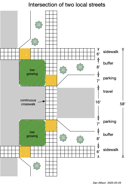
When two local streets intersect, the priority should be for people walking. I’ve created a diagram of what such an intersection might look like, and measure. Notice that the travelway, the area used by moving motor vehicles, is much narrower than is true on most existing streets. This is intentional. Drivers are slowed by their perception that there is a limited space to pass other motor vehicles, or bicyclists for that matter, and limited shy distance from parked cars. Not only does this make the street safer, it also makes it more pleasant for everyone. Drivers traveling any distance will leave these streets in favor of wider/faster streets. Bicyclists can mix with other traffic due to the slow speeds, and do not need a dedicated area. Design and posted speed (if posting is even needed) would be a maximum of 20 mph, and might be less.
Parking is present and welcome, both because it is probably needed, and because it slows motor vehicle traffic. Every corner has a curb extension to shorten the crossing distance for people walking, to increase visibility between walkers and drivers, and to further calm traffic.
Sidewalks of at least six feet, and sidewalk buffers of at least eight feet are included.
Most significantly, sidewalks are raised and extended, with concrete, across the intersection. This enforces the perception that this is a place for walkers, where drivers and motor vehicles are guests. And it is a place where kids could play in the street, as used to be the right of every kid before we let cars dominate our streets. There is still significant pavement for motor vehicles (and bicyclists), but it no longer dominates the neighborhood.
I will address what kinds of streets these are in the future, but what I envision for now is a street with about 80% or more residential, multi-family and single-family. Small businesses on single parcels would be allowed, particularly on corners, but there would be no large commercial or retail, and there would be no surface parking lots.
I believe that in an urbanized area, local streets should be about 5/6 of all streets, so intersections of local streets would be very common. Below is a street grid showing local streets and wider/faster streets. This is similar to but not the same as the Sacramento central city grid. The central city grid has many more wider/faster streets than is proposed for a new grid. Note that the local streets do not need to be straight and oriented with directions. They can wind or curve, so long as they exit in the same direction that they entered. Note in the lower right quadrant the idea that not every local street would meet or cross the corridor streets, but I’m still thinking about this.
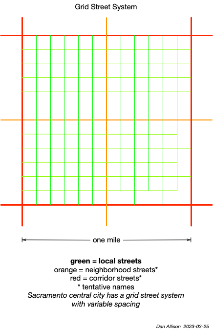
I am still thinking about, and researching what wider/faster streets should look like, and be called, and therefore what intersections of these streets should look like. So there will be more posts and diagrams to come. Note that in the grid street diagram I used the terms neighborhood streets and corridor streets, but these are just placeholder terms. I am set on the term ‘local streets’, though.
My street design outline for the intersection of local streets is:
- walking is prioritized
- design speeds will be no more than 20 mph
- the travelway will be no more than 16 feet, to calm traffic; center stripes will not be used
- curb extensions will be used at every intersection
- as with every type of intersection, ADA detectible warning strips and ramps will be perpendicular to the street
- raised sidewalks will be continuous across intersections; the entire intersection may be raised
- sidewalks will be a minimum of six feet; sidewalk buffers (planting strips) will be a minimum of eight feet
- corner radii will be no more than five feet
- intersections may be uncontrolled or two-way yield; stop signs are not required due to low motor vehicle speeds; signals would never be used at these intersections
- Interim: on existing streets, paint and post curb extensions may be installed; travelway may be narrowed with striping; signals would be removed and replaced with 4-way stops
Stay tuned!

This looks great.
What do you think of the new local streets in Crocker village? There are some raised crosswalks, it’s 30 feet curb to curb so when there are cars parked on both sides of the street there is around 16 feet of clear space. Planting strips and sidewalks are narrower than you prefer though, but it’s also a narrower RoW.
LikeLike
I haven’t looked at those streets through this lens, but will take a look again. It’s on the way to Track 7!
LikeLike
I went to look again during a run. They have some issues, aside from there only being 3 of them. mainly lack of curb extensions so the crossing is still the full 30 or so feet of road, they are not very visible, and they might have maintenance issues at the gutter interfaces.
Extended curbs to pinch the road at intersections are essential to control traffic speed when there aren’t many parked cars.
I looked at some newer infill (Crocker village, McKinley village, and the mill) as well as some of the newer subdivisions in Natomas (Westlake) and they all have 30′ streets (parking both sides) on 50′ right of way, with straight curbs. There is a planting strip and sidewalk which look like 6’/4′ or 5’/5′. This is also true for the older streets in northern Land Park.
Newer streets in Land Park and those in Natomas and East and South Sac, (and presumably every other suburb built between 1940 and wherever the city apparently started requiring 50′ RoW) have 30′ streets (to the outer edge of the rolled gutter), rolled curbs, and 5 ish foot sidewalks on 40′ RoW.
I agree that the planting strip and sidewalks should be wider on a new street, but it also seems worthwhile to plan for what can be adopted on the existing local streets.
I was going to suggest cheating a foot on each section to get to the 50′ goal, and maybe that’s okay, if the fire department can accept the resulting width (26′ total, 14′ travel). NACTO claims that a yield street can be 24-26 feet wide, so there you go.
Another possibility on a 40′ street would be to take a parking lane alternately from each side to allow the desired sidewalk and new (one side at a time) planting width.
LikeLike
I will post shortly on my ideas for types of street changes, which recognizes that we also need street designs when we can change but not redo existing streets.
LikeLike
I marked up an image here. Assume that the crosswalks are raised, of the correct width, and marked appropriately.
I couldn’t find many examples of this pattern (tree planters in parking lane) in the US, but it seems common in Europe (although there are usually no driveways for the houses in that case). With the single-width driveways of the older development (as shown–North City Farms, south of the Children’s Home–the first perfect 40’x40′ intersection I found), you lose less than half the street parking.
Irrigation and storm drainage might complicate the plan though.
LikeLike
Great diagram, thank you. Though I’ve seen photos and in person trees in planters in the parking lane, most have not formalized this. Portland does have a guide, at https://gettingaroundsac.files.wordpress.com/2023/03/street-trees-in-the-pdg-1-pager-v3.jpg.
LikeLike
[…] intersection design post follows on to the SacCity intersections of local streets post, addressing intersections of larger streets. See SacCity street classification for detail on […]
LikeLike