California Bicycle Coalition (calbike) has announced the 2017 California Bicycle Summit, October 3-6 in Sacramento. Preliminary schedule and content is available, as well as registration and application to present. I encourage you to check it out. I’ve registered.
Category: Active Transportation
big smiles at Sunday Street on Broadway
Sacramento’s first open street event* took place on Sunday, Sunday Street on Broadway.
Broadway was closed to cars and open to people from 8 to noon. The route was on Broadway from Riverside east to 26th St, jogged down to 2nd Ave, and then ended again at Broadway. People were wondering how this would work in Sacramento, the first time, and in a place that is pretty car-centric. Well it worked great! A lot of people came out. I’m sure the city will have an estimate, but the initial answer is, a lot.
If success is measured by smiles, and it should be, this event was a great success. People of all ages were there, people from the neighborhood and the region. A lot of people were bicycling, but a lot were walking, and using other wheeled devices. Slide tricycles, which I didn’t even realize were a thing in Sacramento, were common.
Sacramento Area Bicycle Advocates (SABA) created a separated bikeway (protected bike lane) for people to experience, which attracted a lot of attention and generated a lot of discussion about the state of bicycling in Sacramento. Adjacent, WALKSacramento asked people to add their favorite places to walk to a chalk board, all of which were NOT car-dominated places. Some people prioritized how it felt to walk, others their destination. Ice cream was a popular theme.
Outside food vendors were prohibited in order to highlight local restaurants. For those open, business was booming. Some places missed out, though, by not being open. I’d imagine as word gets around how well it works, food retail along future events will be open and prosperous. Many business owners just assume that most of their customers come by car, but places that encourage and activate walking and bicycling all have increased business. Vintage Bicycle Supply was open and crowded with people not even aware it existed, and fans of the CycleFest cruiser bikes. New Helvetia Brewing was quenching people’s thirst and hosting running clubs. There were a lot of sports and fitness vendors, showing people what they had to offer and just providing fun. The two hula hoop groups were particularly popular with kids, and there were chalk drawings everywhere. Sidewalk chalk may be the single most important tool available to the public for activating public spaces.
SACOG and Social Bicycles were showing off the new bike share which opened just Thursday. I heard comments from a lot of people that they found the bikes easier to ride than they thought, and were looking forward to trying it out. [previous post riding the bike share.
The section along 26th St and 2nd Ave was much quieter, with a cluster of local businesses and organizations near the end at Broadway. It was also far cooler than Broadway, with all the street trees moderating the temperature about 10 degrees below Broadway. This was not only much appreciated by people, but points out that for the new Broadway to work for pedestrians and bicyclists, it is going to need to not only not lose many of the existing trees, but to really create a welcoming tree lined street. When I participated in the public meetings the last two years, I didn’t realize how important street trees would be. Since Broadway will be a vibrant commercial corridor, it may be that the big shade trees should be in the median, with less dense trees between the street and retail, so that the view of customers is not obstructed. Interesting design issues.
Hope you had a fun time too! I’m looking forward to the next one.
Photos on Flickr
* Though the county claims its Great Scott road closure is an open street event, it really does not meet the widely accepted definition of an open street.
riding the bike share
Today is the second day of the Tower Bridge Bike Share Preview. I took four trips yesterday, three from hub to hub, and one picking up an out-of-bike bike. And two early morning trips today, both to move out-of-hub bikes. These two bikes were parked at a rack at the other end of the block from the hub racks on R Street. Though I wasn’t there last night, I suspect that the hub racks were full of both bike share and private bikes, and the people could not leave the bikes in the hub. Full racks may be an issue at hubs close to drinking establishments, which 16th, 18th, Capitol, and R St all are. Once the system becomes more widespread, this problem may disappear.
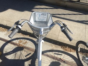
One of the things I do not like about these bikes is the handlebar configuration. They are sort of like beach cruiser bikes, with the angle along the side rather than the traditional handlebar angle. I hate this hand position. After 10 minutes of riding, my forearms were sore. I can put them in a more comfortable position, but only by taking my hands off the brakes. I see other bikes with this handlebar configuration, so I’m sure some people will love these. Not me!
The seat height is adjustable over a wide range, and the seat post has numbered marks so that once you find your comfortable seat height, you can immediately adjust each bike to your height.
The bikes have eight gears, in an internal hub. This is more than flat Sacramento needs, but nice to have. I find myself riding mostly in 6th, going down to 5th at intersections. 1st is very, very low. The bikes are heavy, so the low end gears will help less strong people get moving. Once the bikes are moving, the move along pretty well. They have rod drives rather than chains.
When picking up a bike on 18th Street last night, Steve Hansen was there doing an interview about the bike share system with a TV station. Maybe you saw it on the late news (I don’t have a TV). I talked a bit to Steve, but we both had other places to go. He is obviously pleased to have the new bike share in his council district. This hub was quite busy, and went from five bikes to zero bikes in a flash. I’ve been sort of watching the bike counts throughout the day. Some hubs seem to have a lot of turnover, going up and down frequently, while others don’t change much. This is just my observation, don’t know if the data backs that up.
As I mentioned, I returned three out-of-hub bikes to hubs, and got a credit of $1.50 for each. I have mixed feelings about this. I can imagine myself leaving a bike to go into inside, not sure how long it was going to take and therefore not wanting to put the bike on “hold” but still hoping it is there when I come out. On the other hand, these out-of-hub bikes might sit there for quite some time without being part of the circulation, which hurts availability. It had occurred to me, and Steve also mentioned it, “making a living” bringing these bikes back to hubs, and maybe accomplishing some rebalancing in the process. Of course it is just bike share credit, not real money, but my account balance it larger now than when I started.
The bike hub marker placed in the east end of Capitol Park, with a geofence covering the four square block area, is now gone. This may have been a programming error, or an experiment. After looking, I did not find any racks in the part of the park. However, I thought I saw a positive number in that hub mark during the day. Maybe my imagination.
Photos on Flickr.
almost bike share
The SoBi (Social Bicycles) bike share system in Sacramento is about to launch. The bike racks have shown up on the ground, and just yesterday, on the map.
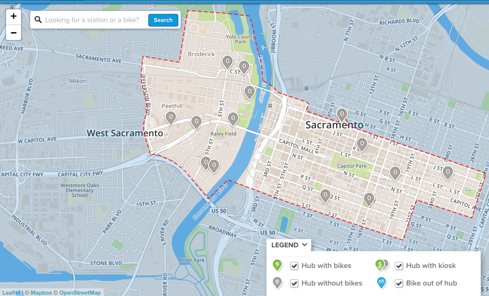
SoBi is a kiosk-less system, unlike, for example, Bay Area Bike Share in which bikes can only be checked out from and returned to kiosks with racks that the bike are designed to lock to. SoBi will lock to any rack, anywhere, as it has an integrated U-lock. As the system opens in Preview mode, perhaps tomorrow there are 14 rack locations or hubs that will have a total of 50 bikes. The map shows the locations, and by the zero in every pin marker, you can tell there are no bikes there yet. This screen shot is from the browser app, but the mobile app is similar.

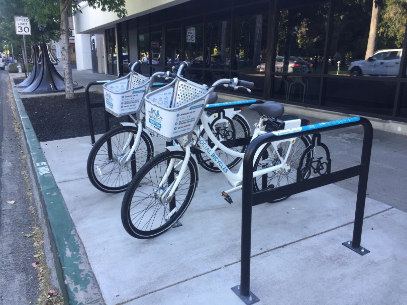
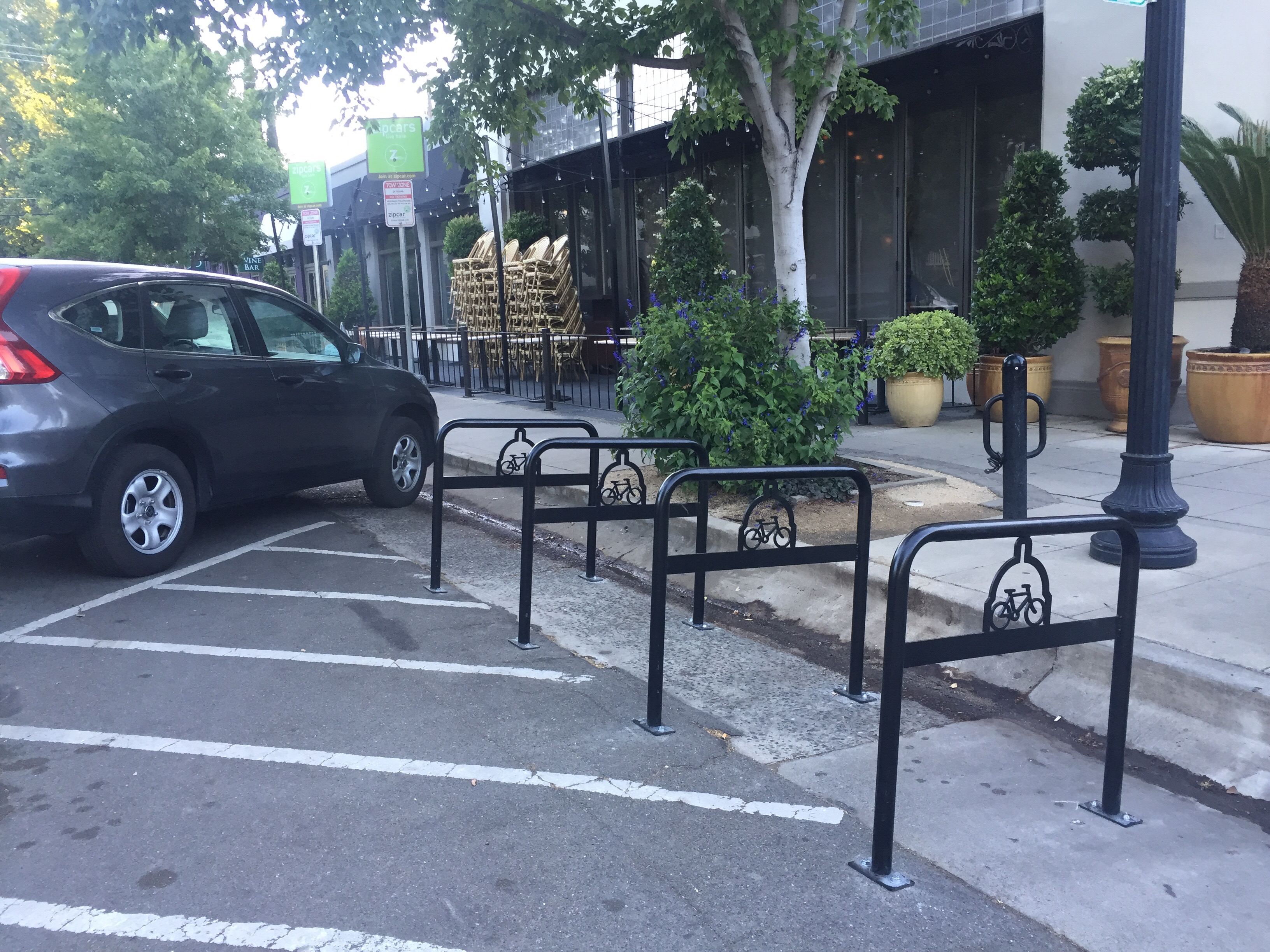
The system is called Tower Bridge, which makes sense, because the preview is in West Sacramento and downtown/midtown Sacramento, linked by the Tower Bridge. In perhaps November the system will be expanded to go as far west as Davis and as far east as Sac State. There will also be some rack locations that look more like traditional kiosks, with information signs. For now, the racks are just traditional bike racks, shown below. This location is on 18th St at Capitol Ave, next to Zocalo and the ZipCar parking spots. The other one in my neighborhood is across the street from the Fremont Park ZipCars, next to Hot Italian. These locations make sense to me, for multi-modal trips, part bicycling and part driving.

I’ve already signed up and banked some money in my account. To be honest, I’m not the target audience for this bike share since I live in midtown and having a folding bike that I can take anywhere, rarely needing to park it outside. But I will try it out as soon as bikes show up, and will probably use it on occasion. At the moment, the only membership type is a timed charge, $4/hour, prorated, with no membership fee. The first 30 minutes free that some other systems use is not offered in this one. There will be other kinds of membership eventually.
More photos on Flickr.
For more information, go to Tower Bridge Bike Share.
on-demand bike lockers at Sacramento Valley Station
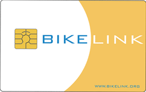
Forty on-demand bike lockers have been installed at Sacramento Valley Station by Capitol Corridor. They are located between the station exit to the platforms and the thruway bus area. These lockers use the BikeLink chip-card system, which I wrote about in 2013 (BikeLink). These join long-term lockers and the Pedal Stop bike station, and new lockers at the Amtrak/Capitol Corridor station in Davis.
Unfortunately, you can’t purchase a BikeLink card in the station, at least not yet. You can purchase them in the Cafe Car onboard all Capitol Corridor trains, but of course if you arrive at the lockers without a card, that doesn’t help you for this trip. You can also order cards via BikeLink. I am not sure how long it takes to get cards through the mail, but I think I remember about a week. The BikeLink map shows three vendor locations in Roseville, since Roseville now has BikeLink locker locations, though I have not used these. The cards cost $20, and that full value is available for locker rentals, though if you use a bike station location with multiple bike racks, such as the Folsom station and several in the bay area, you do have to pay a one-time $5 fee.
The lockers cost 5 cents per hour. That’s a pretty incredible deal given how much car parking costs, and the peace of mind knowing your bike is very unlikely to be stolen or vandalized. Even your seat will be dry!
Hopefully this will be the beginning of more installations showing up around Sacramento and the region, as business and agencies realize what a convenience and encouragement for bicycling the lockers are.
Thank you, Capitol Corridor!
Parkway trail management
Part three of posts on the parkway trail; part 2 Parkway trail flood signing; part 1 Parkway trail low points. This is it for now.
The Jedediah Smith Memorial Trail through the American River Parkway is a major commuting route for bicyclists from the suburbs to downtown, with some reverse commuting as well. It is also a recreational trail, getting a lot of use from recreational bicyclists, walkers, and families on weekends. It is great that one trail can serve so many purposes. However, the trail is being managed by Sacramento Regional Parks as though it were just a recreational trail. The trail is part of the transportation network in the county, and it should be managed as such, of course in a way that is compatible with its purposes of recreation and natural area conservation.
To be specific:
- Directional signage to indicate entry and exit points and junctions with connecting trails is almost nonexistent. Mileage/time to destinations signage is non-existent.
- Park ranger and maintenance vehicles regularly drive on the trail, compressing the decomposed granite walking/running shoulders that have been constructed. These then erode and become muddy, and the vehicles track mud out onto the paved trail. Much of the maintenance work could be done by cargo bike, and much of the ranger patrol could be done by bicycle, which after all works just fine for the Sacramento PD and CHP bike officers. I have never seen a regional parks employee on a bike.
- When the trail is closed by flooding or fire, no information is provided about alternate routes. (see Parkway trail flood signing)
- Low spots on the trail are regularly flooded under moderate rain and flooding events, resulting a broken network. (see Parkway trail low points)
- The entire parkway has remained closed after the recent severe flooding episode, but regional parks has made no effort to inform the public about the sections where easy bypasses are available, such as levee top paths (which are sometimes paved and sometimes gravel, but usually passable). For example, it has been easy to ride from Guy West bridge along the levee, duck under the overpass at Howe Avenue by using paths down to and up from University Ave, and continue on to Watt Avenue, and beyond, but instead regional parks has said the parkway is closed and has not informed anyone of these alternate route. Parts of the trail were never flooded at all, yet remain closed.
- Sacramento Regional Parks receives $1 million annually from the Measure A transportation sales tax in order to maintain the trail. The Sacramento Bicycle Advisory Committee (SacBAC) has questioned how the money is being spent over the years, but has never received a satisfactory answer. It is possible the money is being well spent, and I’m sure the trail is expensive to maintain, but regional parks is not being transparent.
- There are almost no user facilities on the western end of the trail between Watt Avenue and Discovery Park. A drinking fountain at Howe Avenue was removed three years ago and never replaced. There are no bathrooms in this section, other than the smelly pit toilet at Watt Avenue and the almost unusable pit toilet near the Expo Parkway access point (which leaks waste into the waterway, no less). There are some benches or tables, but few and far between.
- Root humps regularly develop in the trail, which is natural given the riparian zone and large trees. So far as I can tell, the paint markings to flag these hazards are all made by trail users, not by regional parks. When things get really bad, they are repaired, but long after the point at which they become dangerous. The same issue exists with beaver burrow slumps, common in the section between Expo Parkway access and Sac Northern trail.
If Sacramento Regional Parks cannot manage the trail as part of the transportation network in the county, then perhaps it is time to pass along management of the trail (not the parkway) to another agency.
Please check the “Storm-Related Parks Update” on the Sacramento Regional Parks homepage.
Parkway trail flood signing
Part two of posts on the parkway trail; Parkway trail low points.
When the parkway trail has been flooded this year, all the way back into December but increasingly this spring, Sacramento Regional Parks has closed various segments, and even the entire parkway at times. This is understandable. The trail is, after all, in a riparian area, and what defines riparian areas is an abundance of water.
Regional Parks has posted some information about the trail on their website, particularly as more and more of the trail has been closed, and is up-to-date with a complete closure now. In December and early January the website information was frequently out-of-date. Their Twitter account has had somewhat better information about the parkway, but it focuses mostly on motor vehicle access and not on trail access and usability.
Parts of the trail are quite usable right now, but rather than addressing those parts, all of the trail is closed.
Parkway trail low points
There are two low spots on the American River Parkway trail (officially called the Jedediah Smith Memorial Trail) that flood even under moderate rainfall or flood conditions. It may seem strange to bring these low spots up when just last week perhaps 90% of the trail was underwater. The trail is in a riparian area, and so will and should flood during major flood events. But the trail is also a major commuter route for hundreds people who work downtown and live to the east, as well as a few reverse commuters like myself. After the jump, details and solutions for these two problem spots.
Walk Score update 2016-12
Walk Score offers an assessment of the walkability of any location. It is available in any browser at https://www.redfin.com/how-walk-score-works. The Redfin app shows walk score, bike score and transit score for each listing (scroll way down). Walk Score is based on the distance to the places people want to go, such as grocery stores, restaurants, coffee shops, bars, movie theaters, schools, parks, libraries, bookstores, fitness locations, drug stores, hardware stores, and clothing & music.
I’ve been curious about whether my Walk Score has changed with all the recent development in the area, since my earlier posts Walk Score (2012-03), Transit Score (2012-04), Bike Score (2012-05), and WalkScore update (2014-01). It has!
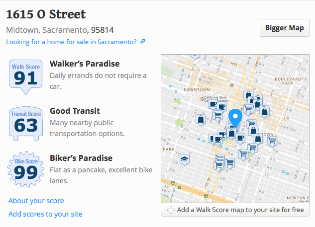
In March 2012, my Walk Score was 85: Very Walkable. In January 2014, my Walk Score was 82, Transit Score 62, and Bike Score 99. And today, my Walk Score is 91: Walker’s Paradise, Transit Score 63: Good Transit, and Bike Score 99: Biker’s Paradise. No big change in transit or bike, but a climb in walk score. And I am still tickled pink to be living where I do, in midtown Sacramento.
Quite a bit has changed on the Walk Score website over the years, and it is now much more focused on real estate. It has more in-depth information, but the algorithm is still proprietary. One of the beta features is a crime score, and my neighborhood ranks as a B.

car-free Sacramento

It is amazing what one can find going through drafts of posts that were composed but never posted. Here is one from 2017.
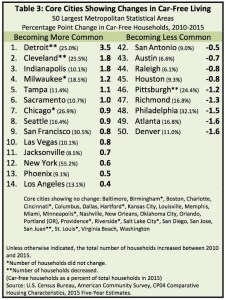
Recently reported research on car-free households in states, major metropolitan areas, and major cities, Car-Free Living in the United States: What the Data Says, indicates that Sacramento metropolitan area increased its car-free households by 0.5%, and the core city (mostly the city of Sacramento) from 9.7% to 10.7%, from 2010 to 2015. Sacramento is #6 in the list at right, not bad
My previous post on car-free workers was Central city car-free workers (2016-04-24), which indicated a central city rate of 5% to 18%, depending on zip code. Since these statistics are workers rather than households, they are related but not directly comparable, since the number of workers per household is often more than one, but sometimes zero.