Walk Score offers an assessment of the walkability of any location. It is available in any browser at https://www.redfin.com/how-walk-score-works. The Redfin app shows walk score, bike score and transit score for each listing (scroll way down). Walk Score is based on the distance to the places people want to go, such as grocery stores, restaurants, coffee shops, bars, movie theaters, schools, parks, libraries, bookstores, fitness locations, drug stores, hardware stores, and clothing & music.

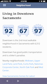
I live at O St and 16 St in mid-town Sacramento P and 12th in downtown Sacramento, which has a WalkScore of 85, very walkable, shown at right. The R St and 16th St corridors, which have higher scores, are easy walking distance. The Neighborhood section of the app offers Walk Score, Transit Score, and Bike Score, but for the entire neighborhood of downtown, not for specific address.
The browser interface offers more information, for both specific addresses and general areas such as Sacramento. The graphic below is only part of the web page. Note that the results from the app and the web site are not the same, and I don’t know why, but they are similar enough that it should not make a big difference.

The exact algorithm that weights these amenities is not public, but you can get an idea by selecting the Street Smarts Walk Score option. Having six grocery stores within 0.6 miles, eight restaurants within 0.2 miles, and eight coffee shops within 0.3 miles supports my score. One critical item not on the list is farmers’ markets, which I would weight very highly, though the seasonal nature of most farmers’ markets might be a challenge. The closest one to me is two blocks away, but it only runs May through September. It is only 1.4 miles to the year-round farmers’ market at 8th St and W St. Some performance theatres show up in the movie theaters category, but some of them do not, so I’d make that a separate category since plays are such an important part of my life.
The browser interface also offers a Transit Score, and mine is 60: Good Transit. It is only 4 blocks to light rail for me, and some buses run only a block away, so I would have guessed it would be higher, but it is still not bad.
On the other hand, the place where I work, in Carmichael, has a miserable score of 35: Car-Dependent. Of the schools I work with in Citrus Heights, the most walkable has 66: Somewhat Walkable, and they go down from there, some of them way down, as low as 26.
These scores are no surprise. Walkable places feel like walkable places, and car-dependent places feel like car-dependent places. I picked mid-town in which to live because it felt walkable, though I did check the Walk Score as well to confirm that.
My life is enjoyable because there are so many things to do so close. I can walk to almost anything, and can bike to more distant places. This morning I walked to the coffee shop, Old Soul Coffee on Leistal Alley, and then I walked to the grocery store, Grocery Outlet on Capitol Ave. Shortly I’m headed over to another coffee shop to post this, and then off to celebrate St. Patrick’s Day at a restaurant/bar, deVere’s on L St. Tomorrow I’m be biking to hear music, and then to Crocker Art Museum. For me, this is a quality life. A number of my friends who know me as “Mr. Natural,” the person who spends a lot of time outside and the summer’s backpacking, have expressed surprise that I’d live in a city at all, but here I am. I’ll say more in a future post about that balance between city and nature.
The tag line for Walk Score is “Drive less, Live more,” and that pretty well summarizes it.

[…] previously wrote about Walk Score and its use in Sacramento, and now the Walk Score company has released Transit Score. Sacramento […]
LikeLike
[…] my Walk Score has changed with all the recent development in the area, since my earlier posts Walk Score (2012-03), Transit Score (2012-04), Bike Score (2012-05), and WalkScore update (2014-01). It […]
LikeLike