 To complete the story about crosswalks, the locations where crossing is prohibited must also largely be removed. These locations are marked with the ‘no crossing’ sign at right (MUTCD R9-3a). Some of these locations probably never had crosswalks, some had them but were removed when the street was ‘upgraded’. A few of these locations cannot be made safe without complete reconstruction of the street. Freeway on-ramps and off-ramps, of which Sacramento has too many because it has too many freeways and too many freeways designed around commuting instead of interstate commerce, are particularly problematic. However, most locations indicate a clear intent by traffic engineers to prioritize the movement and speed of motor vehicles over all other considerations, including safety. This bias must be ended.
Here are the solutions:
- The city should be required to perform a complete traffic study on each and every location with a prohibited crossing. The traffic studies should be completed within two years.
- If the traffic study indicates that the prohibition is necessary for safety, then the prohibition can remain, but a new traffic study must be completed every five years. If the traffic study indicates that the prohibition was not made for safety reasons and is not needed for safety reasons, the prohibition must be removed and a marked crosswalk installed.
- City staff will analyze each prohibited location that remains to determine what redesign would make the prohibition unnecessary, and bring to the city council a proposal to expend funds to fix the location.
- At all prohibited locations, the city would be required to post informational signing with distances to the nearest safe crossing, in both directions.
Though I am picking on the City of Sacramento here, these prohibited crossings are found in every city in the region, and in abundance in unincorporated areas. All should receive the same treatment.
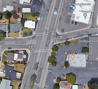 As you can see to the right, at the intersection of Freeport and Oregon, there are residences to the west and businesses to the right. There are signalized crosswalks about 700 feet to the north and about 700 feet to the south, but walking to either of these adds a one-quarter mile walk. Is this reasonable or not? It could be argued either way, but to discount it as Mr. Moore did demonstrates bias against pedestrians. The Google Map photo is from before the removal of the crosswalk.

 I attended the bike share open house hosted by the City of Sacramento last night. There were as many people representing partners and consultants as members of the public, and I did not see any low income or people of color. SACOG staff were present, as SACOG is the sponsoring agency for the bike share program, staff from Toole Design Group which is managing planning and selection of bike rack locations, and staff from


 Curb extensions, also called bulb-outs, have been installed on all four corners at the intersection of 16th Street and N Street in midtown Sacramento. The extensions are the width of the parking lanes along both these streets. N Street has bikes lanes, which are not restricted by the extensions, while 16th Street does not have bike lanes, and won’t until the street is reconstructed into a more complete street at some unknown point in the future.
