This is a typical car-brained response to solve an issue. While it is true that a car trip to the airport has a fraction of the carbon impact that your flight has, nevertheless, it is possible to get to the airport without touching a car, your own or ride-hail.
SacRT has Route 142, once an hour, and Yolobus has Route 42A/42B, once an hour or better. Though the schedules are not fully integrated (yet), this results in about 30 minute service frequency to and from the airport. SacRT’s buses are electric, and take about 20 minutes for a trip from downtown to the airport, without stops, while Yolobus’s are fossil fuel, and take about 20 minutes for the trip, downtown Sacramento to the airport. The clockwise/counterclockwise loop buses also serve Davis and Woodland.
You can plan your trip with Google Maps or the Transit app (highly recommended).
How much does it cost? SacRT $2.50 per ride (and 90 minute transfer) or $1.25 discount, or free for K-12 students. Yolobus $2.25 or $1 discount. Compare that to parking at the airport, $2/30 minutes, with a maximum of $10/day up to $30/day. Ride-hail? $30 to $168, depending on time of day and surge pricing, according to the Bee article. Want to throw your money away for perceiving convenience? Go ahead.
So, get out of your car, or anyone’s car, and on to the bus. And leave your car-brain behind.
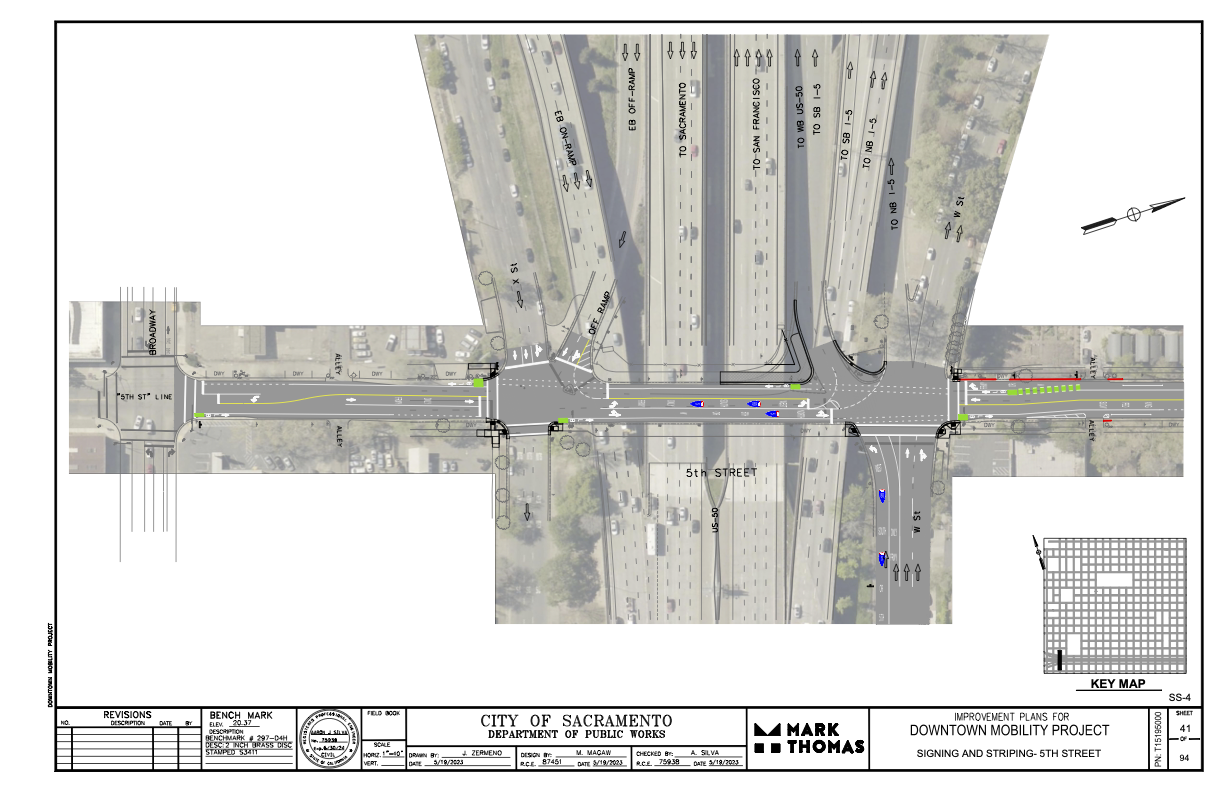
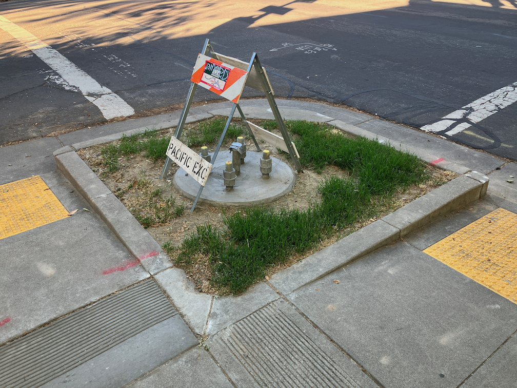
I had earlier expressed concern and lack of information about where the 5th Street one-way to two-way conversion will be handled where 5th Street passes under Hwy 50. (Yes, I know, that this is technically not Hwy 50, but everyone thinks it is, so…)
The following diagram was provided the the city and design firm (pdf). The configuration looks workable, and it probably not any less safe than the current mess. The merging of the two on-ramps into one narrower entrance will probably help to slow traffic entering the freeway, making 5th Street a bit safer. Same with the narrowing of the off-ramp. The curb line will need to be moved in a few locations to accommodate the entire street width with bike lanes, but the curbs here are already quite deteriorated, so that work would be needed in any case. It is not clear from the diagram whether the missing sidewalks in the block between Broadway and X Street will be corrected.
Electric vehicles (EVs) are touted as being the solution to many of our climate change problems. Most of the money being spent on climate change current is going to EV subsidies and to creating widespread charging networks. They also dominate the conversations about climate change, pushing other issues and solutions to the margin. I’m sick of this (I’m tired of the electric vehicle conversation), and become more sick by the day. They are only a small part of the actions we need, and they should not be receiving the bulk of the funding.
The hype and commitment to electric motor vehicles also pushes out the real climate solution (and livability solution), electric bikes, whether privately owned or bike share systems. Entities from the city to the county to the state to the federal government claim that there isn’t enough money to really support the transition to elective bikes. Why? Because almost all of it going to EVs.
If we depend on EVs to solve our environmental or social problems, we’ll will end up with exactly what we have today, which is world dominated by motor vehicles and traffic violence. Except it will be worse, because we’ve put all our eggs in one basket.
Paris Marx in Road to Nowhere: What Silicon Valley Gets Wrong about the Future of Transportation, addresses the boosterism in Chapter 3: Greenwashing the Electric Vehicle (ISBN 978-1-83976-588-9). Conservative magazine Forbes offers The Expensive And Harmful Truth About Electric Vehicles. Volt Rush: The Winners and Losers in the Race to Go Green (ISBN 978-0861543755) covers the mining and battery manufacturing side of electric vehicle production. If you search the Internet, you will find articles and sources ranging from ‘EVs are the single solution to everything’ to ‘EVs will be the end of us all’. The truth, is of course, somewhere in between. It is early enough in EV adoption that we really don’t know that much about overall and long-term effects. Nor is there an effective battery recycling industry yet (though it is not hard to find dead Teslas, with their batteries waiting to be recycled).
Much of the Inflation Reduction Act and Infrastructure Investment and Jobs Act, as well as other federal investments, is going to subsidizing the purchase of electric vehicles, and creating charging networks. As is well known, almost all the existing EV subsidies at the federal and state levels have gone to high income individuals. Little in the current and planned programs will change that. Though there is work to make subsidies more equitable, every proposal has met with significant blowback. The rich want to preserve their perquisites.
I suppose the thing that most irritates me personally is the ‘more environmental than you’ attitude of Tesla owners. They live, though not speak, as though their purchase of a Tesla has absolved them of all other environmental harms. Tesla owners are part of the ‘I’m richer than you, so I can do anything I want, and I can drive in any way I want’ crowd. For more on Tesla the real instead of Tesla the hype, see Ludicrous: The Unvarnished Story of Tesla Motors, Edward Niedermeyer, ISBN 978-1948836128.
My greatest concerns about EVs are:
all cities and counties can do is provide charging, all other aspects of the transition are largely beyond their control; this sends the locus of control to a higher level of government, further from people
the transition will be slow, and there will be fossil fuel vehicles on the road long after net-zero is intended
it turns out EVs are not the environmental panacea claimed, with battery manufacture, rare earth mining, and battery recycling (or lack thereof, turns out almost no batteries are being recycled)
EVs are not and will probably never be affordable to low income people, and nearly all the subsidies so far have gone exclusively to high income individuals
EVs have the same or worse pollution potential as fossil fuel because the main health impacts of motor vehicles are not tailpipe emissions, but road dust, tire dust, and brake dust, which are all exacerbated by the higher weights of EVs
EVs kill pedestrians and bicyclists just as effectively, if not more (higher weight), than fossil fueled cars
Why this topic today? Because I’m about to get to some posts on the City of Sacramento Climate Action and Adaptation Plan. The plan prioritizes EVs in its solutions to GHG reduction. Ack!
Note: Info on 9th Street and 10th Street added below.
For other posts on the City of Sacramento Central City Mobility Projects, see category: Central City Mobility Project. I’m not sure how interested readers are in my minor updates, but I think it is fascinating to see how the city is repurposing street right-of-way, solving problems (or not), and what is being prioritized in the overall project. I’ve not seen any signs of construction on P and Q streets, other than the ADA ramp work that has been going on for several weeks.
Turn Wedge
The project page has a diagram that I had not exactly seen anywhere before, the corner wedge, below.
Central City Mobility Project diagram turn wedge
I saw a location marked for a turn wedge yesterday, at 21st St and O Street, southwest corner, below. This is a little bit like a corner of a protected intersection.
Sac_21st-St-O-St-SW_turn-wedge
5th Street Two-Way Conversion
I looked at the length of 5th Street, from Broadway to I Street. I still have no insight into what will be done under Hwy 50 where there is a one-way block that is closely tied to the freeway onramps. I have requested clarification from the city but they have not answered yet. I’ll update when I hear.
Signal bases have been installed for new signals from W Street to N Street, but not north of there. Active work was going on at N Street. At R Street, it looks like the existing pedestrian flashing light will be duplicated for the other direction. This is not a full signal, nor a user-activated signal, but always on.
Between Broadway and X Street, 5th Street is two-way, four lanes, with sharrows marked (and very faded) in the outside lane. Sharrows are no longer considered valid bikeway markings, so presumably there will be marked bike lanes here. There are three very-wide blocks for 5th Street, from N Street to L Street, and from J Street to I Street. From N to L, there are two through lanes and one or two left-turn lanes, plus parking and bike lanes. From J to I, there are two through lanes and two left-turn lanes, plus parking left and right and a bike lane on the right.
On the west side of the intersection of 5th Street and I Street, there is a crossing prohibition. I hope that the city removes this prohibition as part of the project. In most cases, freeways onramps and off-ramps being an exception, crossing prohibitions are an attempt by the transportation agency to prioritize motor vehicle volume and speed over all other considerations. They are morally wrong, and should be legally wrong.
Sac_5th-St-N-St_extra-wide
I Street Separated Bikeway (and lane reduction)
Some work has started on the I Street separated bikeway, which will run from 21st Street to 12th Street (see the importance of I Street for why it should continue west). Most corner ramps were already ADA compliant, but the few that were not have either been upgraded or are in progress. Fabric covers have been set up over drain inlets, and temporary no parking signs line the street, so I assume repaving will occur soon. I don’t see any indication of whether the separated bikeway will be on the right side or left side of the street. I Street does not have SacRT fixed route bus service, which engenders left side bikeways, though there is some commuter bus service on the street.
The project map indicates that I Street will be “lane reduction and separated bikeway”, not parking protected separated bikeway, so this will be a different configuration than 19th Street and 21st Street.
I will be interested to see if the city will address the lack of sidewalk on the south side of I Street between 16th and 15th, where the city installed a loading dock for Memorial Auditorium in place of the former sidewalk. I strongly believe that removal of sidewalks, as was done here, are criminal (Sac permanently closes sidewalk).
19th Street Repaving
It looks at though 19th Street is not going to be completely repaved in the way 21st Street was, rather, it is getting spot repaving. I don’t know whether there will be an overlay so that the new marking are on a fresh blank canvas.
9th & 10th Street Parking Protected Separated Bikeway
The 10th street parking protected separated bikeway will be extended from Broadway to Q Street. The block of Q Street to P Street has a buffered bike lane, outboard of parking in the south half, and without parking in the north half, and since that block has recently been changed, it will likely stay that way. There is a buffered bike lane from Q Street to L Street, and then a parking protected separated bikeway of variable quality from L Street to I Street. There is no bus service on 10th Street, so the right side configuration will probably be maintained throughout.
10th Street is relatively wide under Hwy 50, so no special treatment here will be needed.
On 10th Street there are ADA ramp upgrades at several locations, and several more haven’t started yet. The street has a lower rate of ADA compliance than many central city streets. There is no indication of roadwork yet.
The 9th Street parking protected separated bikeway is being extended south from L Street to Q Street. There is no indication of any sort of work here yet. Most corners already have compliant ADA ramps. There is construction on the east side of 9th (right side southbound) between L Street and Capitol Mall, and on the west side (right side southbound) between N Street and O Street, and between P Street and Q Street. All of these construction projects will probably be going on for quite some time, and this may be the last street to be modified. SacRT Bus Route 51 runs on 9th Street south of Q Street to Broadway, which is outside this project scope, but presumably argues for keeping the left side bikeway configuration throughout.
The informal Walkable City book club had a good discussion on Wednesday evening. There were only four of us, but we filled up the time with thoughts and questions about parking in the city.
To the question of what is the next action that could be taken, answers were:
create red curb offsets at every intersection, reducing parking by one space or so, to increase visibility between walkers, bicyclists and drivers
change parking rates so that garages are utilized more, getting cars off street parking
adjust the hours and areas of metered parking so as to cover evenings and ensure parking turnover even after the workday
The next book club meeting will be Wednesday, June 14, 6:00PM, at Lefty’s Taproom, 5610 Elvas Ave, Sacramento, CA 95819. The patio area has some shade umbrellas and misters to cool us off. And cold beer, of course.
Discussion will be on Step 4: Let Transit Work (page 139 in the second edition). We hope you will join us!
The SACOG Regional Bike Share Policy Steering Committee met this week on Monday (agenda). This was the first meeting of the committee in quite some while, long enough that the staff member did not remember when the last one was. The committee is almost entirely new people since the last meeting. Members are: Alberto Ayala (Sac Metro Air Quality District), James Corless (SACOG), Dawnté Early (City of West Sacramento), Caity Maple (City of Sacramento council member D5), Katie Valenzuela (City of Sacramento council member D4), and Chair Josh Chapman (City of Davis).
There was a presentation by SACOG staff Nicole Zhi Ling Porter on the status of bike share/scooter share (or micromobility) in the region, as well as questions that the policy committee will help answer. The main question is the ownership and operations model, with three options”
privately owned and operated (the current model)
publicly owned and operated
publicly owned and privately operated (under contract)
These are not exclusive categories. Several existing bike share programs have detail models for operations, using some sort of public/private partnership.
The City of Davis and UC Davis are undertaking a study to determine the model they want to use and the operators. They did not rejoin the regional program after the pandemic shutdown. It has apparently not been decided that they will not rejoin the program, but they wanted to consider other options. There may be an announcement about this in the near future.
The current bike share fleet is about one-third the number of bikes that were available before the pandemic, which was about 900. Sacramento was in fact the most successful bike share system in the country, as measured by number of rides per bike per day. The system is now an also-ran.
Several committee members mentioned that rental costs were now much higher, and that was probably depressing use. I have to admit that I am a Lime Access member, meaning that I don’t pay for individual rides of up to 30 minutes, so I have not noticed the per-minute fees.
I was the only public person in attendance in the room. One person spoke on Zoom, but I have not way of knowing if there were more people observing on Zoom. Note that I am a user of the bike share, not of the scooter share, and don’t have much perspective on scooters, I expressed these concerns, which I hope committee will address:
Instability: The unannounced shutdown of the system at the beginning of the pandemic was not the desire of the public, which wanted to continue using the bikes. This type of issue, determined solely on the whims of the operator/owner, is not acceptable to the users, and any new policy must address this issue.
Maintenance: The bikes are not being maintained to an acceptable level of good repair. About 1/4 of the bikes I try to rent are unrideable for various reasons, about 1/4 are rideable but have significant issues, and about 1/2 are more of less OK.
Distribution: The agreement between the operator/owner requires that some bikes be distributed/rebalanced into low income neighborhoods within the service area (many are not in the service area, but some are). My observation, both from being on the streets and checking the app, indicate that this is not being done.
Transit integration: The JUMP bike share system was for a time somewhat integrated with transit. Bike charging stations were located at a number of light rail stations. But when Uber took over the system, these charging stations were removed. So there is no integration at this time. Bike share and transit can complement each other in critical ways, but the current system is operating without that insight. There are a few systems in the country where the transportation/transit agency also operates the bike share system, Los Angeles Metro for example. Though this system is not perfect, the integration is noticeable, and the rental rates are significantly below that of private systems.
More information on the curb extensions (bulb outs) being installed on the northeast and southeast corners of the intersection of 19th Street and O Street, as part of the Central City Mobility Project. I questioned this location for curb extensions because 19th Street with have a parking protected separated bikeways on the left side (southbound) of 19th Street. (Central City Mobility update)
I received a response from the engineering firm for the project:
This is in response to your inquiry as to compatibility of the subject intersection revisions and parking protected bike lane. The design does account for the bulb outs at the intersection. Unfortunately, due to the space restrictions resulting from the bulb outs, it won’t be possible to provide parking protected all the way around the bulb outs. However, we are providing a transition of the bike lane at the intersection. Please take a look at the following striping design for the intersection. North is to the right with 19th Street running left to right. Hopefully this will give you a better feel for the plan:
Any reader of this blog will know that I love curb extensions. What confuses me is why this location would have been selected by the city over many other potential locations. Perhaps some of the reason it that the crossing at O Street has a moderately high walker count, but does not otherwise have a traffic signal or pedestrian signaling such as a RRFB. It is possible that the city thought these four corner curb extensions to be the most practical way of increasing safety for walkers and bicyclists crossing at this point.
The design of bringing the separated bikeway out adjacent to the general purpose travel lane, as a bike lane, is not ideal but not particularly unsafe. In fact some bicyclists prefer this design, because it increases the visibility of bicyclists by motor vehicle drivers, so that they are not ‘hidden’ behind parked cars. Though daylighting of the intersection approach can accomplish the same objective.
I would like to see green skip paint continuing through the intersection in the bike lane. These are often painted as discontinuous green rectangles with sharrows stenciled on top, called green-backed sharrows. The sharrows are out of favor with most bicyclists and some traffic engineers, I think this is a valid use of them. The main purpose of green paint (it has no legal meaning) is to increase driver awareness of bicycle facilities by highlighting conflict points, and this is definitely a conflict point.
I live close to Fremont Park in Sacramento’s central city. I walk through the park every day I’m in town, often multiple times. That means I’m crossing through the bounding intersections of P Street & 15th Street, Q Street & 15th Street, Q Street & 16th Street, and P Street and 16th Street, multiple times a day. I also spend a lot of time at Naked Lounge on the southeast corner of Q Street and 15th Street, and some time at Karma Brew on the northwest corner of P Street and 16th Street. That gives me a front row seat to watching the behavior of drivers at these intersections. On nearly every signal cycle, I seem a driver running the red light at each of these intersections. This is not a the exception, it is the rule. By running the red light, I don’t mean entering the intersection on yellow and finishing on red, I mean entering the intersection on red. I mean drivers that are intentionally endangering themselves, other drivers, bicyclists, and walkers. Every signal cycle.
Though I’m an able-bodied and aware walker, Fremont Park is also used by a lot of homeless individuals, families using the playground, people sitting on the benches and reading, people lying on the grass and enjoying the sun (finally) and enjoying the shade (now), people participating in a number of organized recreation activities such as yoga, and of course the festivals such as Chalk It Up. This is a place that should be safe to get to for everyone. It is not currently.
Let me state up front that I am NOT in favor of the enforcement of traffic laws by armed police officers. I have seen first-hand the way in which traffic stops are used to harass and oppress people of color and low income. I have read and seen innumerable accounts of officers murdering the people they stop on pretext. Armed law enforcement is the problem, not the solution. On the other hand, I am strongly in favor of automated enforcement. It is my theory that most serious traffic violations are by a small number of egregious drivers. Automated enforcement can ticket these drivers, which will change the behavior of some of them, but not of many of them who are high income drivers of high end vehicles. It does, however, allow law enforcement to identify repeat offenders and hold them accountable with vehicle confiscation and drivers license suspension.
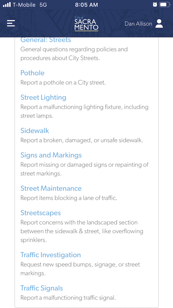
I want there to be red light enforcement cameras installed on at least one of the four intersections at Fremont Park. My observations indicate that the intersection of Q Street and 15th Street is the worst. I looked on the city’s Red Light Running Program page to see if there was a mechanism for submitting requests. No. I looked at the city’s 311 app to see if there was a place to submit a request. Not really. The closest I could find was to select Streets > Traffic Investigation, and then Signals (see screenshots below). I’ll update this when I get a response (though these days most 311 reports get no response at all).
screenshots from Sac311 app
The other way of request that might be effective is to directly contact city council members.
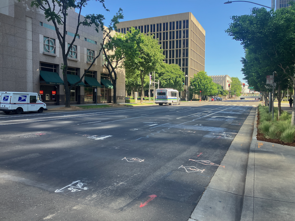
One of the elements of the Central City Mobility Project is the conversion of 5th Street from a one-way, two-lane street, to a two-way, one-lane each direction street. Some work is underway: wiring and signal bases have been installed for the signals necessary for two way traffic at the existing signal locations. Looking at the bases, photo below, I’m guessing that there will be new signal poles and mast arms, not re-use of the existing signals equipment. That seems like a waste of money to me, but the city loves to spend money on new signals, and signal controllers.
I am not sure that many of the current signal locations are even needed. After the conversion, 5th Street will be a lower speed and probably lower volume street. Four-way stops at some major cross streets (such as T Street) might work just fine. Again, the city loves to spend money on signals, and already has unneeded signals at a number of locations (too many traffic signals?).
5th St and T St new signal base
The Central City Mobility Project map shows the 5th Street conversion as extending from Broadway to I Street. The block between Broadway and X Street is already two-way, as are the two blocks between L Street and J Street (the DOCO underpass). It is also two-way north of I Street.
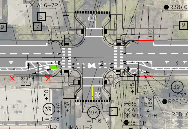
I wonder what, if anything, will be done for the block between X Street and W Street, under the Hwy 50 freeway. This is a very complex block, with a freeway onramp west of 5th Street and a freeway offramp west of 5th Street. The onramp and off-ramp have separate signal phases from X Street and W Street. Traffic westbound onto the ramp, if it makes the green light, is already traveling at freeway speeds, about 65 mph as it crosses 5th Street. Similarly, but not as egregious, the off-ramp traffic, if it makes the green light, is traveling a bit below freeway speeds. I am really not sure how this complex situation can be made safe for bicyclists. Northbound bicyclists only have to deal with drivers running the red light at 5th Street from W Street, but southbound bicyclists would have to deal with multiple turning vehicle movements. In general, the only way to make complex situations like this safe is to have exclusive bicycle phases in which only bicyclists and walkers are moving, no vehicle movement or turns are permitted. But the city is very unlikely to select that safe alternative because it would lengthen the signal cycles and therefore slow motor vehicle traffic to some degree. The city doesn’t want to slow motor vehicle traffic.
The diagram below, from Google Maps, indicates the complexity of this block, but the reality on the ground is even worse.
So the neglect of the Central City Mobility Project for fixing these two blocks of I Street is disturbing. Of the people riding on I Street anywhere west of 16 Street, probably 50% are going to Sacramento Valley Station. But if you spend time on I Street looking for bicyclists, you won’t see many. The average bicyclist won’t ride on I Street. They are uncomfortable with the volume and speed of motor vehicle traffic, but more importantly, they are scared to death of these two one-block sections with only sharrows. So they drive to, or have someone drop them off at, the station. Sacramento Valley Station is the most important transit hub in the city, in the county, and in Northern California outside of the Bay Area, yet the city has neglected access to the station.
The TIRCP grant for improvements at Sacramento Valley Station may improve access from the station on H Street, but again, that is not a near term project, and it is not clear how effective it will be. Probably 80% of the riders on H Street are coming from the station. (Sac kill those sharrows on H St, H St bicycle fixes)
My observation of bicyclist numbers and destinations is based on observation and talking to some riders. It would be nice if the data were available, but I don’t have it, and apparently the city doesn’t have it, or at least has never shared it publicly. I know that the city purchased cell phone data several years ago that would have allowed them to see bicyclist patterns, but so far as I know, they only used it for motor vehicle drivers patterns.
I St shadows between 10th St and 9th St, Sacramento