![]() The City of Sacramento is soliciting input on the North 12th Street Complete Street Project, the most significant portion of which would install a two-way cycletrack on the west side of 12th Street between the Hwy 160 bridge over the American River near Richards Blvd, and as far south as F Street.
The City of Sacramento is soliciting input on the North 12th Street Complete Street Project, the most significant portion of which would install a two-way cycletrack on the west side of 12th Street between the Hwy 160 bridge over the American River near Richards Blvd, and as far south as F Street.
The project should be compatible with and benefit from the Choice Neighborhoods Initiative Twin Rivers project which would revitalize the Twin Rivers Community Housing and the surrounding area. The January 2014 Final Transformation Plan is available from SHRA. Though the plan does not go into great detail on streets and transportation, page 78 does provide a good overview of the changes and the relationship to 12th Street and other efforts in the River District and Railyards. In particular:
- Richards Blvd would be realigned and extended east of 12th St
- several streets intersecting 12th St would be reconfigured, particularly Bannon St
- a potential SacRT light rail station near the redevelopment and Richards Blvd
There is also a City of Sacramento project to add sidewalks to the east side of 12th St between B St and Richards Blvd.
Since the project emphasizes the two-way cycle track, I first have comments on that:
- Soft hit posts, even with a painted buffer, as shown in the graphic the city uses on the “Learn More” page, do not provide safe separation of bicycle traffic from motor vehicle traffic. The posted speed limit of the section from the river to B St is 35 mph, and from B St to F St is 30 mph. Though the city does not have, or has not posted, any recent traffic counts, the website lists 13784 ADT (average daily traffic) in 1992. These speeds and volume argue strongly for physical separation by a curb or median. The NACTO Urban Bikeway Design Guide provides a graphic for a raised median design, below. If the speed limit on this entire section were lowered to 25 mph, then soft hit posts with painted buffer would probably provide sufficient safety and comfort. This would be a desirable change in any case, as there is no reason to have any roadways in dense urban areas over 25 mph.

two way cycle track with raised median protection (NACTO) - The utility and safety of cycle tracks are directly related to the number of street intersections and driveways, with fewer being the desired design. A cycle track that is interrupted by short block intersections and any driveways will be significantly less safe and comfortable that one which runs long distances. Driveways should be eliminated and intersections reduced. Free right turns are also incompatible with cycle tracks, so free rights from Richards Blvd eastbound to 12th St southbound, from 12th St southbound to Richards Blvd westbound, and from 12th St southbound to Sunbeam Ave northbound must be eliminated or at least converted to stop-required turn lanes. Though the Richards Blvd realignment might address this issue, it is certainly possible that the cycle track would be installed long before the Richards Blvd change is made.
- The cycle track should provide connection not just to the westbound Twin Rivers path, but to the future eastbound path, and to any bicycle conveyance across the American River that might be developed in the future. Though the highway bridge is just downstream from the existing Sacramento Northern bridge, that bridge does not provide easy connection back into the street grid to the south and the Del Paso area to the north. Conveyance of bicycle traffic over the highway bridge should be a long term goal. Though these additional projects will occur after the 12th St project, they must be included in the design.
- The entrance to the northbound cycle track lane at the southern terminus of the cycle track must be addressed with an innovative design that might include traffic calming, contra-flow cycle track, and bicycle-specific signals. If bicyclist cannot safely enter and exit the cycle track, it will not get used.
- The intersection of 12th St, B St, and Dos Rios St must be reconfigured, not just for safety of bicyclists, but for pedestrians and motor vehicle drivers as well. The wide open intersection is no place for a cycle track, and certainly not for pedestrians. The curve of 12th St from south-southwest to south must be moved either to the north or to the south so that this major intersection is rectilinear. Probably Dos Rios St should be reconfigured so that it connects only with B St and does not connect with 12th St at all.
- The most important part of the project for bicyclists is from the highway bridge to C St. Though an extension south to F St, as mentioned on the project pages, or even further to I St or L St, is less important because bicyclists can disperse off 12th St into the grid starting at C St.

Additional points not directly related to the cycle track:
- In addition to the cycle track, this section of 12th St, and south as far as at least H St, or perhaps L St, should have dedicated transit lanes for the southbound light rail tracks. Only the northbound light rail tracks have a dedicated lane or separation at this time. As more travel shifts from privately owned vehicle to public transit, bicycling, and walking, there is a need to devote more roadway capacity to these other modes and less to privately owned motor vehicles. At this time, light rail, express bus 29, and portions of routes 15 and 33 use 12th St. As transit use increases and the area is redeveloped, however, light rail trains will be more frequent and additional bus routes are likely to be added. The potential additional light rail station near the realigned Richards Blvd will also argue for dedicated transit lanes. San Francisco has had great success speeding up their transit system by installing red marked transit-only lanes on major arterials (photo below). In San Francisco, taxis are allow to use many though not all of the red marked transit-only lanes.
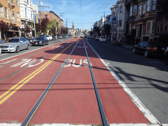
red transit-only lanes in San Francisco - 12th St should be reduced to two motor vehicle travel lanes along the entire one-way length from the river to I St. Highway 160 has a two-lane pinch point north of the river, so having more than two lanes south of the river should not be necessary. While the conversion of the fourth motor vehicle lane on the northern section of 12th St has many advantages, a reduction to only two lanes southbound would create a more walkable, bikeable, and livable area.
- 12th St between I St and J St should be converted into a two-way, single lane street. I St and all the streets to the north can serve to disperse southbound traffic back into the grid, and eventually allow J St itself to be traffic calmed.

I just noticed a very disturbing scene in the North 12th Street Complete Street Project video at http://n12street.com/wp-content/uploads/2014/12/Exam-With-Project.m4v. At 1:18 in the video, the pedestrian using the crosswalk over 12th Street is endangered by a motor vehicle driver not yielding to the pedestrian, in violation of CVC 21950. A frame grab is here, but it is much easier to see in the video itself.
LikeLike
[…] I posted on the North 12th Street Complete Street Project, I expressed concern about how the cycle track to the north would transition to the bike lane to […]
LikeLike
I added a post on protected intersections which addresses the transition from the cycle track to the bike lane.
LikeLike
The survey comments and the community open house summary have been posted on the North 12th Street website.
LikeLike