The City of Sacramento recently release a new 311 app. I have been using this app (iOS version), mostly to report issues with construction signing. The app is broken!
What are the issues?
If you switch away from the app to some other app, the app logs you out, and you have to log in again.
Once you’ve logged in again, it asks you to confirm your contact details. Even though it asked you to do that moments ago – it doesn’t keep track.
It will not allow you to upload photos. Usually it give an error message, photo could not be uploaded, but sometimes it hangs the entire app. If you are wondering, it makes no difference whether you take the photo then or try to use an existing photo, nor what size you attempt to upload.
The app (and the website) is happy to show you requests you’ve made, but the only information on the request is the cross streets or address that you reported. It doesn’t show what the request was, so if you’ve made more than one request on the same location, or simply don’t remember what the request was, you won’t get any help from the app (or the website).
An ongoing problem, not specific to the app, is that the city closes requests without saying whether they did anything or not. The only way for you to know whether they did anything is to go back to the same location, and look to see. That’s if you remember what your request was.
The convention center and community center theater project (3C) project did a very poor job of preserving access for walkers and bicyclists at the beginning. Some issues have been resolved, but some never have, though the project has now been going on for just less than two years.
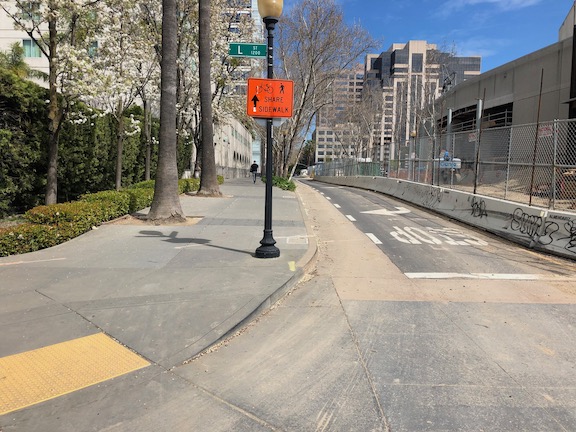
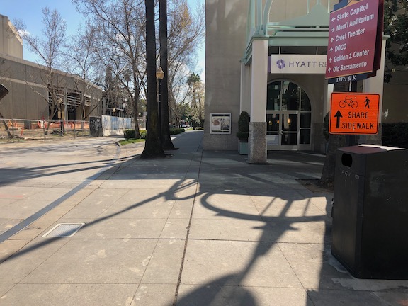
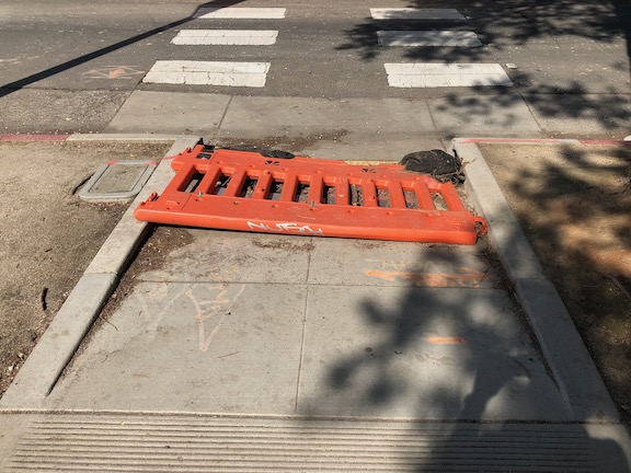
The most significant issue is that there was no provision made for northbound bicyclists on 13th Street, passing the construction between L Street and J Street. 13th is a major bicyclist route of travel, and the city knew this before the construction started. But the original traffic plan did not address this use at all. After public complaints, a sign was installed on the sidewalk for northbound bicyclists, photo below, but not the southbound. The numerous walkers using this sidewalk, adjacent to the Marriott and Sheraton convention facilities, were confused to see bicyclists on the crowded sidewalk. After more public complaints, a sign was added southbound, the second photo, though it is placed in a location where people coming from K Street would not necessarily see it. As you can see in the first photo, the sidewalk is narrow just north of the crosswalk, so bicyclists heading north are brought into immediate conflict with pedestrians heading south, many of whom are headed to the crosswalk over L Street. Of course having an angled ADA ramp here, rather than the two-to-a-corner design that should be used wherever there is significant pedestrian traffic, makes things worse.
Of course the best solution here would have been to just close 13th Street to motor vehicles between K Street and L Street, leaving the narrowed roadway available for two-way bicyclist traffic. There are far more bicyclists using this route than private vehicle drivers. Despite that, the city biased in favor of drivers.
13th Street northbound at L Street13th Street southbound at K Street
One issue on which progress was made was the southeast corner of J Street and 13th Street. Initially this corner was closed, giving walkers only one choice of how to cross, despite this being one of the most heavily used intersection crossings in the city. There was no reason to close the corner off, the area behind the fence was never used for construction. After about a year and a half, the corner was re-opened, photo below, so that walkers have a choice of routes. Note that when the city finally worked on this corner, the work was not done behind the fence, but the fence was moved and then the sidewalk and ramp work done by closing off the corner until it was done.
J Street & 13th Street, southeast corner, finally re-opened
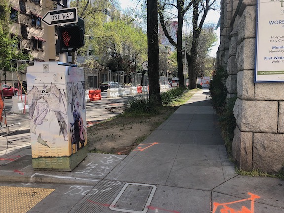
On the east side of the project, issues remain. The sidewalk from J Street south along 15th Street has no signing indicating that it is closed ahead, see photo. When you get half way, there is just a fence blocking access. In daylight, you can see the fence ahead, but a limited vision person and anyone walking at night would not see the fence until they got to it. This is simply unacceptable.
15th Street west side, southbound from J Street, no signage
There are several other less serious issues around the east and south sides. At K Street & 15th Street, there is no signing to indicate how to get to the other side, to go either northbound or southbound. This one is not hard to figure out, at least for sighted people, but it was still not done correctly. This crosswalk ramp should have been barriered off, just like the ADA compliant barriers in the previous post, since it only leads to a closed crosswalk.
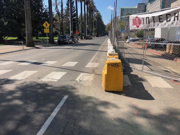
On the south side of the project, there are plastic barriers for the crosswalk over 14th Street at L Street, and for the crosswalk over L Street on the west side of 14th Street. These barriers were knocked over months ago and have not been put up again. There were not sufficient to begin with, but laying down on the ground, are both useless and hazardous.
14th Street at L Street, failed barrierL Street at 14th Street, west side crosswalk, failed barrier
I’m going to call this one a failure on the part of both the construction company and the city: the construction company for failing to monitor and maintain the traffic control devices for which they are legally responsible, and the city for failing to monitor the construction company. Blame all around!
And lastly, the closure of a lane on L Street for the construction was not handled well. As you can see, there is a narrow crosshatched area the length of the block. One might reasonable choose not to go this way, but then again I see people going this way every day, both walking and bicycling. I am not sure how this should have been handled, but there must be a better solution. Of course one solution would have been to continue a temporary pedestrian walkway on the north side of the street, set off by concrete barricade, and requiring only a simple fence to separate the walkway from the construction site. If more street width was required, parking could have been removed from the south side and the general purpose lanes shifted to the left. Note there there never was a bicycle lane present in this block, it is dropped at 15th Street and the traffic sewer 3-lane roadway continues west.
L Street westbound at 14th Street, narrow shoulder
In closing, this construction project is probably the worst in the city (though there is competition). It does not involve a private property owner, it does not involve a state construction project, it is a city project on city land. There is simply no excuse for such poor walker and bicyclist accommodation. It is a big middle finger to those to who don’t drive.
Since there will likely be a long string of posts on construction zones done wrong, I want to point out that they can be done right. This is one from yesterday. Though the crosswalk closure here was less than one day, it was signed properly, and the detour was very short, about 30 feet west to the next crosswalk.
N Street at 12th, clear construction zone signingN Street at 12th, clear detour signing
Construction projects all over the city of Sacramento continue to bias motor vehicle travel over walkers and bicyclists. This has been going on for a long time, and it has not gotten any better. A few construction projects handle it appropriately, most do not.
One issue that I ran into yesterday is particularly galling because of the long detour it takes to bypass the construction site at the corner of J Street and 4th Street, at the California Fruit Building (not sure if it will have the same name after reconstruction). From the southeast corner of J Street & 3rd Street to the southeast corner of J Street & 4th Street is 380 feet, along a sidewalk which has been closed by construction. The detour is 785 feet, but the important issue is not the distance but the time. The detour requires pressing five beg buttons and using five crosswalks, a walk of 7.25 minutes, most of that time waiting for the pedestrian signal to change. A direct route would be just over a minute.
J Street south side, eastbound past 3rd
This map (Google) shows the detour.
What are the alternatives? One is that a travel lane could be removed from J Street. Both a pedestrian walkway and a bicycle lane could be temporarily installed in this section past the construction. Another is to install a crosswalk on the east leg of the J Street & 3rd Street intersection. Pedestrian crossing is currently prohibited (by signing and guard rail) at this location, but the prohibition is solely for the flow of motor vehicle traffic and the convenience of drivers, it has nothing to do with pedestrian safety. The crosswalk need not be temporary, it could be a permanent installation. Of course this crosswalk would require two crossings, but two is better than five.
Short of these two real fixes, the signing could be better. In the photo below, there is an unobvious sign indicating a detour to the west, but it doesn’t say which sidewalk. I did not understand what it meant until I had walked down to the construction fence. On the sidewalk that is closed, there is no indication until reaching the construction fence that the sidewalk is closed. There should be some indication of how long, or how many crossings, for the detour. A person might decide to turn around and head south to L Street, or to the access points to K Street, if they had more information. This photo also shows the pedestrian prohibition established for traffic flow rather than pedestrians safety.
In the westbound direction, there is even less information. The sign says sidewalk closed, and there is a vandalised construction arrow, which might or might not indicate the detour route.
J Street south side, westbound at 4th
I don’t blame most of this type of issue on the construction companies. The construction company has to get a permit from the city, which includes a traffic plan. The city is accepting, and in some cases encouraging, traffic plans with no, or insufficient, accommodation for pedestrians and bicyclists, and insufficient signing. Of course the construction company wishes to minimize the work and the signing, but it should be the city’s responsibility to ensure good traffic plans. It rarely does. I will remind readers again that the city employee who supervises this permitting process said that pedestrians and bicyclists would be accommodated if it did not interfere with traffic flow.
Since I have time on my hands, I’ve been walking a lot more in downtown/midtown, with social distancing of course, so I hope to add additional posts on this topic.
The city will be enforcing both parking and traffic for the electric assist bike share JUMP, and the JUMP and Lime electric scooters. Many people are still riding the scooters on sidewalks, so I would expect citations for that. Under state law, not Sacramento law, scooters must be ridden on the street. The amount of parking that endangers or impedes walkers has fallen off over time, so there should be much less of that, but it will be interesting to see how exactly that will be enforced. The city still does not have sufficient bike parking, particularly in neighborhoods but even in commercial and mixed areas, and though it has installed a few bicycle and scooter corrals, they are far from enough.
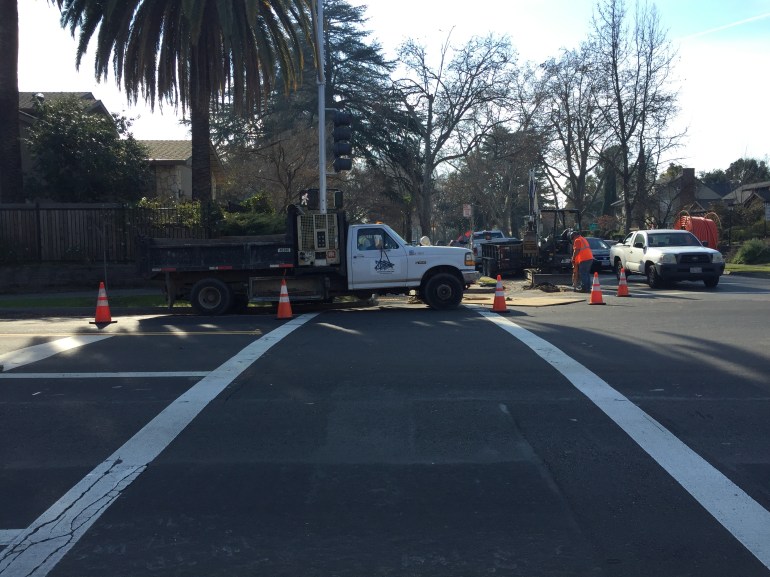
Sacramento City continues its practice of approving construction projects that do not consider the needs of walkers and bicyclists. Here is the latest I ran across, on Folsom Blvd between Santa Ynez Way and 39th St. The construction on the south side appears to be installing cable or fiber. At the west end, there is a sudden ‘sidewalk closed’ sign. There is no prior warning, there is no ramp or marked crosswalk for crossing Folsom to the north side (it requires crossing an offset intersection diagonally to go from one ramp to another, an exceptionally long distance), and there is no indication about how long the detour is.
At the other end, there is the same sort of signing without any prior warning or information provided.
At this location, 39th St, there is a marked crosswalk with traffic signal which could allow people to cross Folsom, but just to make sure the message that pedestrians are unwelcome here is clearly received, a construction truck was parked across the crosswalk. When I asked the construction crew to move the truck, they refused. I reported it to parking enforcement but am not sure of the outcome.
Of course there is a bicycle lane along this section of Folsom Blvd, which is also blocked by the construction. That may be justifiable, but you would think that forcing bicyclists to share the general purpose traffic lane would justify a reduction of the speed limit from 35 mph to 25 mph, but no, that that would inconvenience drivers and in the city, that is not to be considered.
This kind of bias against walkers and bicyclists should be unacceptable in the city. And it would be if the staff of Construction Services were not biased against walkers and bicyclists. Time to replace that staff with people who care about all modes of travel.
This information from the City of Sacramento via email.
We have added and updated upcoming outreach events for the Vision Zero Top 5 Corridors.
Join us to learn more about the Vision Zero Top 5 Corridors Study and share your experience biking, walking and driving along these streets at one of the following events:
Date and Time
Event
Location
Corridor of Interest
Monday, November 5th
5:00-7:00 p.m.
Community Workshop
Peter Burnett Elementary School
6032 36th Ave.
South Stockton Blvd.
Wednesday, November 7th
Noon-2:00 p.m.
Pop-up Event
Transit stop at Broadway and Stockton near Food Source (4401 Broadway)
Broadway/Stockton Blvd.
Saturday, November 10th
9:30-10:15 a.m.
Old North Sacramento/Dixieanne Community Association
GraceCity
701 Dixieanne Ave.
El Camino Ave.
Thursday, November 15th
5:00-7:00 p.m.
Community Workshop
Luther Burbank High School
3500 Florin Rd.
Florin Rd.
Thursday, November 15th
6:30-8:00 p.m.
Gardenland/Northgate Neighborhood Association
Stanford Settlement Conference Room
450 W. El Camino Ave.
El Camino Ave.
Friday, November 16th
4:00pm-6:00 p.m.
Pop-up Event
Grocery Outlet
2308 Del Paso Blvd.
El Camino Ave.
Wednesday, December 5th
6:00-8:00 p.m.
Hagginwood Community Association
William J. Kinney Police Facility
3550 Marysville Blvd.
Marysville Blvd.
About the Study
In 2017, the City of Sacramento identified the five corridors in Sacramento with the highest numbers of fatal and serious crashes involving pedestrians, bicyclists, and motorists.
The Vision Zero Top Five Corridor Study will analyze the factors that contribute to these corridors’ high crash rates. Based on technical analysis, community input, and best practices in roadway safety and design, the study will identify improvements for each of these corridors that can be implemented in the near-term.
At the community meeting, Ryan Moore kept saying “we followed the law” in removing crosswalks. Though he was not specific, the law he may have been referring to is the section of California Vehicle Code (CVC) below. It remains to be seen if this law was followed, but it may have been since the requirements are minimal. Residents in the neighborhood were uniform in saying that they had not seen any notice, but that does not prove it did not occur. There are additional legal requirements on the city that will be addressed in future posts.
CVC 21950.5. (a) An existing marked crosswalk may not be removed unless notice and opportunity to be heard is provided to the public not less than 30 days prior to the scheduled date of removal. In addition to any other public notice requirements, the notice of proposed removal shall be posted at the crosswalk identified for removal.
(b) The notice required by subdivision (a) shall include, but is not limited to, notification to the public of both of the following:
(1) That the public may provide input relating to the scheduled removal.
(2) The form and method of providing the input authorized by paragraph (1).
Questions about using Leading Pedestrian Interval (LPI) signals at the community meeting on crosswalks reminded me that I had information on these in the city for some while, but hadn’t shared it. A LPI signal gives the pedestrian a 3-second (or more, but the Sacramento ones are all 3 seconds) head start, with the walk sign coming on before the light turns green, so that pedestrians will already be in the crosswalk and more visible before vehicles start to move. These address the common issue of both right-turning and left-turning vehicles failing to yield to pedestrians in the crosswalk. They are one of the pedestrian safety countermeasures identified by the Federal Highway Administration (FHWA), with a crash reduction factor of 60%. If you search for ‘leading pedestrian interval’ on the Internet, you’ll see a great number of useful links. The NACTO page is especially worthwhile.
My purpose in sharing the specific locations is so you can go out and experience LPI for yourself. How does it work for you?
A LPI does slow traffic very slightly since there is an additional 3 seconds per direction during which most vehicles are not moving.
Lastly, this is not a solution that could have been used at the Freeport-Oregon intersection, which is not a signalized intersection. However, it is a solution for the signalized intersections along Freeport. Ryan Moore claimed that these can’t be used at low pedestrian locations, but the response to all such reactionary claims is: “You can’t judge the need for a bridge by the number of people swimming the river.” If crossings are not safe, then fewer people are walking than otherwise could be. The demand is there, but not the facility. LPIs are one solution.
Lead Pedestrian Interval (LPI) locations in City of Sacramento (as of 2015-08-28):
The city is doing a speed study on Freeport from Sutterville Rd to Meadowview Rd, and will include part of Sutterville (not clear what part)
There are no red light cameras on Freeport; the city piggybacks on country red light program
There are no lead pedestrian interval signals on Freeport, or even is south Sacramento (all are in the central city); Ryan Moore said these should not be used in low pedestrian areas (which is false)
Resident commented on Fruitridge Rd, 24th to Freeport, a lot of red light running and few safe crossings
Resident who lives on Oregon suggested changing the speed limit on Freeport
Steve Hansen says that the city would like to change Freeport, but to do so, the community (residents, businesses, neighborhood associations) will need to come together to decide how; people will have to give up some time for better safety; he also mentioned narrow sidewalks with obstructions
Several people asked about or commented on specific sections and intersections; Matt mentioned catching egregious speeders
South Land Park Neighborhood Association (Ryan?) asked what public notice there was before crosswalk removal and said they were not notified; not clear if the other two were notified
Ryan Moore said that each removal was analyzed, he says they followed the law of CA MUTCD; said most of the removals were result of complaints; said neighborhood input makes no difference; mentioned FHWA info on crosswalks, referring to Zegeer report though not by name (more info about Zegeer in a future post)
Neighbor said that any process that removes crosswalks is flawed; mentioned no still phase on signals (time between red one direction and green the other); going out of the way is not reasonable to ask; can’t have data on people walking because people are scared to walk
Steve Hansen and Jay Schenirer want to review pedestrian guidelines, not sure what document this is; said we need to talk about equity because the top corridors of Vision Zero concern are not necessarily located in disadvantaged communities
Neighbor said speed display signs don’t seem to have any effect on behavior; asks for immediate action and not years out
Ryan Moore continually says “we’d like to but we can’t” but offers no proof; continues to say that crosswalks at this volume and speed are not safe
Neighbor said there are bus stops close to Oregon which is true and which might make removal a violation of Title 6
Issue of sidewalk maintenance responsibility has come up several times; city continues to insist that it is the responsibility of the property owner (even though most sidewalks are part of the public right-of-way and all are part of the transportation network)
Many people pointed out that improvements could have been made at the Freeport-Oregon intesection, such as bulb-outs, refuge median, lighting; there is a median already but it is too narrow to provide refuge
Participant asked for a pedestrian commission, Jennifer Donlon Wyant said the the city Active Transportation Commission would be seated in April or May
Jay Schenirer wrapped, mentioned that McClatchy students drove the changes to Freeport north of Sutterville Rd
My overall take on the community meeting is that the city council members and the public, both residents of the neighborhood and others, want proactive changes to increase pedestrian safety and walkability. They don’t want excuses. Ryan Moore, the Interim City Traffic Engineer, seem prepared only to offer excuses.
Of all the people on stage, Ryan Moore seemed the least sympathetic to the person killed, or the issues that it raises. He said much the same thing he’d said to the SacBee: “Instead, traffic engineers hope that by removing some crosswalks, pedestrians will instinctively choose to cross at a safer, nearby intersection,” Moore said. He kept referring to federal and state standards that were being followed, though a number of people in the audience who know a great deal about traffic engineering noticed that he was mis-stating and mis-using standards and research to defend his actions and opinions.


 Questions about using Leading Pedestrian Interval (LPI) signals at the community meeting on crosswalks reminded me that I had information on these in the city for some while, but hadn’t shared it. A LPI signal gives the pedestrian a 3-second (or more, but the Sacramento ones are all 3 seconds) head start, with the walk sign coming on before the light turns green, so that pedestrians will already be in the crosswalk and more visible before vehicles start to move. These address the common issue of both right-turning and left-turning vehicles failing to yield to pedestrians in the crosswalk. They are one of the pedestrian safety countermeasures identified by the