Construction projects all over the city of Sacramento continue to bias motor vehicle travel over walkers and bicyclists. This has been going on for a long time, and it has not gotten any better. A few construction projects handle it appropriately, most do not.
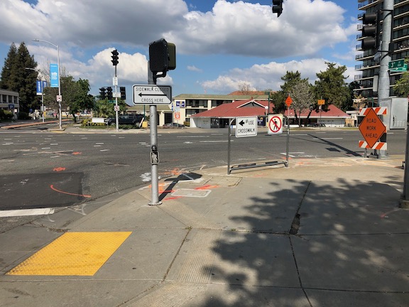
One issue that I ran into yesterday is particularly galling because of the long detour it takes to bypass the construction site at the corner of J Street and 4th Street, at the California Fruit Building (not sure if it will have the same name after reconstruction). From the southeast corner of J Street & 3rd Street to the southeast corner of J Street & 4th Street is 380 feet, along a sidewalk which has been closed by construction. The detour is 785 feet, but the important issue is not the distance but the time. The detour requires pressing five beg buttons and using five crosswalks, a walk of 7.25 minutes, most of that time waiting for the pedestrian signal to change. A direct route would be just over a minute.

This map (Google) shows the detour.

What are the alternatives? One is that a travel lane could be removed from J Street. Both a pedestrian walkway and a bicycle lane could be temporarily installed in this section past the construction. Another is to install a crosswalk on the east leg of the J Street & 3rd Street intersection. Pedestrian crossing is currently prohibited (by signing and guard rail) at this location, but the prohibition is solely for the flow of motor vehicle traffic and the convenience of drivers, it has nothing to do with pedestrian safety. The crosswalk need not be temporary, it could be a permanent installation. Of course this crosswalk would require two crossings, but two is better than five.
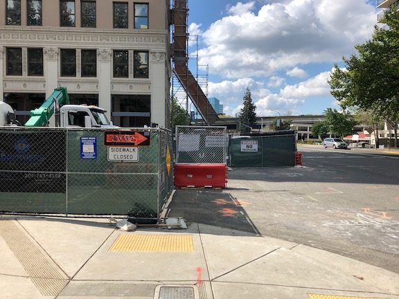
Short of these two real fixes, the signing could be better. In the photo below, there is an unobvious sign indicating a detour to the west, but it doesn’t say which sidewalk. I did not understand what it meant until I had walked down to the construction fence. On the sidewalk that is closed, there is no indication until reaching the construction fence that the sidewalk is closed. There should be some indication of how long, or how many crossings, for the detour. A person might decide to turn around and head south to L Street, or to the access points to K Street, if they had more information. This photo also shows the pedestrian prohibition established for traffic flow rather than pedestrians safety.
In the westbound direction, there is even less information. The sign says sidewalk closed, and there is a vandalised construction arrow, which might or might not indicate the detour route.
I don’t blame most of this type of issue on the construction companies. The construction company has to get a permit from the city, which includes a traffic plan. The city is accepting, and in some cases encouraging, traffic plans with no, or insufficient, accommodation for pedestrians and bicyclists, and insufficient signing. Of course the construction company wishes to minimize the work and the signing, but it should be the city’s responsibility to ensure good traffic plans. It rarely does. I will remind readers again that the city employee who supervises this permitting process said that pedestrians and bicyclists would be accommodated if it did not interfere with traffic flow.
Since I have time on my hands, I’ve been walking a lot more in downtown/midtown, with social distancing of course, so I hope to add additional posts on this topic.
