Update 2026-02-16: California Vehicle Code (VEH) 21456 (a)(1), implemented by AB 1909 Vehicles: bicycle omnibus bill in 2022, allows: …the operator of a bicycle facing a pedestrian control signal displaying a “WALK” or approved “Walking Person” symbol may proceed across the roadway in the direction of the signal, but shall yield the right-of-way to any vehicles or pedestrians lawfully within the intersection.
Following on to the benefits of leading pedestrian interval (LPI) signals for walkers, more LPIs, these signals can also benefit bicyclists.
I routinely see bicyclists proceeding on the pedestrian signal, before the traffic signal has turned green, at every location with a LPI. And that’s what I do. Technically it is not legal to do so, so I would like to see state law changed so that it clearly is legal. Even though unlikely to be enforced, there is no reason to give law enforcement a pretext to harass bicyclists.
The permission should be for bicyclists proceeding straight, not for bicyclists turning. Though a turning bicyclist presents a tiny fraction of the danger to walkers of a motor vehicle driver, I still don’t want to see walkers using the LPI to feel intimidated by bicyclists.
When the stop as yield at stop signs, and the stop and proceed when safe at stop lights, is eventually passed in California (this is called the Idaho stop law, though it is now in several other states and being considered in more), this proceed on LPI will become moot. However, being somewhat cynical (or very), I suspect that CHP will succeed in deep-sixing any such change in law for a number of years.
The simpler step forward of permitted bicyclists to proceed straight on LPI should not be controversial with anyone, and could be passed and implemented this this legislative session.
I wrote some while ago about leading pedestrian indicator (LPI) signals, which give the pedestrian a head start of a few seconds before the parallel traffic light turns green. So far as I know, Sacramento has not added any locations to the list of eleven.
But the city should. In fact, I’d argue that any traffic signal where there are a significant number of walkers, and a significant number of turning drivers, should have an LPI. Drivers often fail to yield to people in the crosswalk when turning, or cut in right behind them, and the more chance the walker has to get out into the crosswalk and visible, the better. Of course nothing about the LPI prevents the driver from turning on red, unless turns on red are prohibited. Prohibiting turns on red has been much discussed lately, but I don’t think that treatment is the most important that can happen at intersections.
I live a few blocks from Fremont Park, which is the block between 15th Street and 16th Street, and P Street and Q Street. In fact, many of the parks in the central city are located between pairs of one-way streets, called couplets. 16th is one of the busiest streets in the central city, and the other two are moderately busy, and these four intersections see a lot of turning vehicles. Since I walk nearly every day to and around the park, I get plenty of chance to see how drivers interact with walkers in the crosswalk. I’ve never seen anybody hit, but I often see conflicts, the driver trying to intimidate the walker, trying to beat them to the crosswalk, stopping just short of hitting them, or cutting in close behind them.
P Street and Q Street are two-lane arterials, while 15th Street and 16th Street are three-lane arterials, with higher traffic volumes and vehicle speeds. 16th was a state highway.
So, I’m asking the city to install LPI signals for the south crosswalk at 15th & P, the east crosswalk at 15th & Q, the north crosswalk at 16th & Q, and the west crosswalk at 16th & P. The photos below show the intersection of 15th & P from pedestrian level, and overhead. The video shows two pedestrians crossing, and mostly through the crosswalk before the driver encroaches. This was a low traffic time with only one turning vehicle. When I have a chance to capture a heavier traffic time with pedestrians, I’ll replace it.
P Street westbound, showing crosswalk over 15th St ahead15th Street & P Street, south crosswalk
crosswalk over 15th Street at P Street
I often write about the Sacramento central city because that is where I live, and I have ample opportunity to observe transportation infrastructure and driver, walker and bicyclist behavior. However, I’d like to state that I DO NOT think that central city issues should be solved first. These issues occur in many places in Sacramento, where the traffic is higher speed, facilities are poorer, and neighborhoods have been disinvested. Drivers in the central city are just as bad as drivers elsewhere, in fact most of them are from elsewhere, the suburbs, but they have grown somewhat accustomed to seeing walkers and bicyclists, and are more careful around them.
The section of 9th Street in Sacramento, between K Street and L Street, finally has an acceptable walking and bicycling pathway around the construction on both sides of the street. It looks as though the construction on the west side of 9th is getting closers to completion, so the sidewalk blockage on that side may disappear, but the east side construction is just beginning.
9th Street walking and bicycling bypass
The pathway is about 12 feet wide, as originally promised, so that is taken care of. There are cones down the middle, the purpose of which I’m not clear about since there is no indication of directional or mode separation, but they do no harm. The signing and barricades on both the north side and south side are still lacking, the barricades not meeting ADA detectability requirements, and the signing less than ideal.
Two days ago the fencing had been pushed out into the pathway area. I’m not sure if this was a one-time occurrence, or will keep happening. The next day it was back in the right place.
After my moving the cone out of the bikeway on the approach at K Street several times, it seems to be staying out of the way.
This safe pathway for walkers and bicyclists is the direct result of citizen complaints, mine and several others. If not for these complaints, the city and the construction contractor would not have done anything. So, please report violations of ADA accommodation through the city’s 311 system, and if that doesn’t result in change, complain to your city council member. Though the city is working on new policy intended to address these failures, I suspect that indifference is so embedded in city staff that it will take a long while to see proactive solutions, and we will need to continue to report and complain for some while.
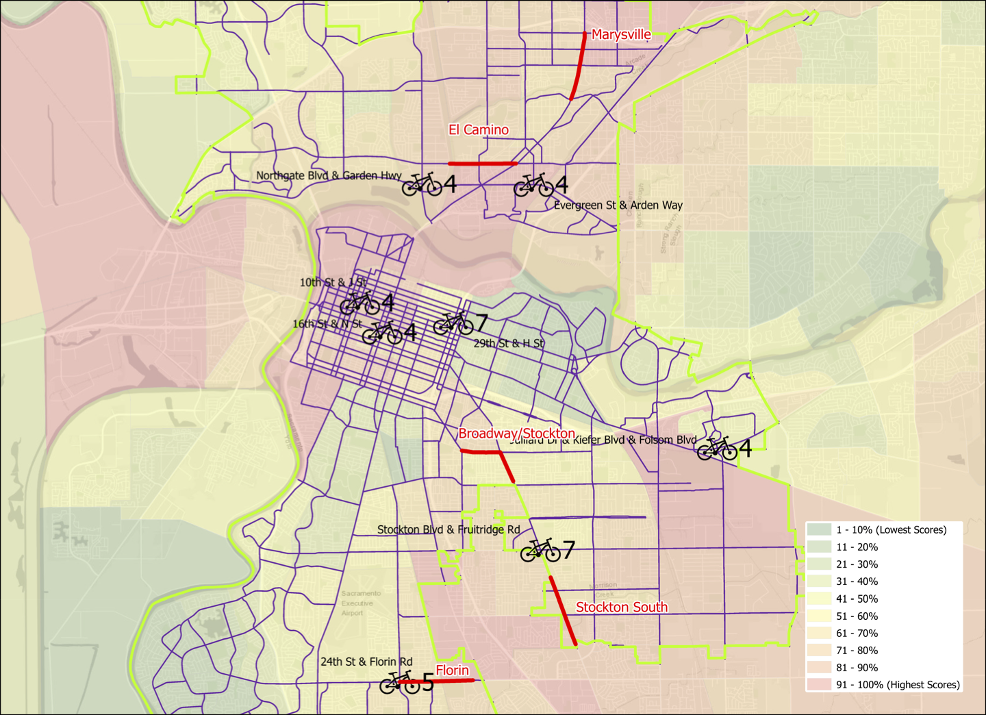
As promised in my previous post, Sac Vision Zero flaws, here is a limited analysis of high injury network intersections in Sacramento. I used bicycle crashes for 2014 through 2018 from the SWITRS crash database, and matched these to intersections of arterials and collectors in the city. It is known that most crashes occur at or near intersections, not in between. Of the 1112 crashes in this time period, 763 occurred at intersections, or 69% (for all crash types, the city said it is 78%). I selected eight intersections to highlight, which had 4, 5, or 7 crashes at the intersection or within 120 feet of the intersection, meaning on the approach or departure from the intersection. The other 590 intersections had 3, 2, 1, or no crashes. I did not analyze the crashes for fatality or serious injury, but that would be a useful.
The map below shows the Sacramento Vision Zero Top 5 Corridors, in red, and the top eight crash intersections with a bicycle symbol. The number to the right is crashes, and the location is labeled with cross streets. This is also available as a pdf.
Of the eight intersections, one is part of the Florin corridor, at 24th Street and Florin Road. The other seven are not.
I ask that the city revise its Vision Zero program to include high injury intersections. The number might be as many as 10, and selection should include the same equity criteria used to select the corridors. That means that the three central city locations might not be selected, or might be lower on the priority list, and that is good. The challenge of the Stockton Blvd & Fruitridge Road intersection is that it is on the city/county boundary, so complete treatment of the intersection would require some cooperation with the county. But with seven bicycle crashes in the time period, it is a very important intersection.
A strong advantage to giving high injury intersections recognition and attention is that they could receive near-term safety improvements that require only reallocation of roadway width and new paint. Full safety improvements probably would require redesign of the intersection.
Again, I fully support the city’s Vision Zero efforts, and want to see them be the best they can be. That means including high injury intersections.
Addition 2021-03-02: Someone asked how the bicycle collision locations relate to disadvantaged communities. Below, a map with CalEnviroScreen 3 2018-06 (CES) layer, with red end being higher pollution, green being lower, and weighted with income. CES is not the only measure of disadvantage, but it is one commonly used.
Edit: Added graphics for El Camino – Grove intersection and Broadway – Stockton intersection, excerpted from the Sacramento Vision Zero Top 5 Corridors document.
The Sacramento city council will be considering the new Sacramento Vision Zero Top 5 Corridors document at the council meeting on Tuesday, February 15. It is item 11 on the consent agenda, so will not be discussed unless a council member pulls it from the consent agenda.
I have taken a look at the document, though the one included with the with the agenda is a flat file, not searchable, and with low resolution graphics, making it hard to use. When a high resolution and searchable version becomes available, I’ll link to it.
The document continues the pattern established in the 2018 Vision Zero Action Plan of focusing on corridors and not on intersections. The five segments presented as the top five are segments of El Camino Avenue, Marysville Road, Broadway/Stockton Blvd, Stockton Blvd south, and Florin Road. I believe that this exclusive focus on corridors is a mistake. Nearly all other vision zero communities have a dual focus on corridors and intersections, but Sacramento does not.
The Vision Zero Action Plan acknowledges on page 11 that 78% of collisions occur at intersections, but then seems to ignore this fact in pursuit of corridor projects. Of course if a corridor is done correctly, the intersections will be fixed as part of the project. The issue is that these corridor projects will cost millions of dollars and will require seeking state and federal grants to accomplish. The costs are El Camino $16,450,000, Marysville $12,850,000, Broadway/Stockton $8,750,000, Stockton South $9,500,000, and Florin $11,900,000. And these are only for the most important fixes; less important or more expensive fixes are somewhere off in the distant future. But a focus on the high injury intersections within the corridor could yield significant safety benefit at much lower cost, perhaps within the range of general fund expenditures.
This focus on corridors leads to some flaws in the corridor plans. On El Camino, the plan misses that there is a dropped bike lane at eastbound at Grove Avenue and therefore does not recommend the countermeasure Extend Bike Lane to Intersection. At the Broadway/Stockton intersection, the plan does not recommend the countermeasure Bike Conflict Zone Markings for Broadway eastbound and westbound approaching Stockton, and seems to completely drop the bike lane on Stockton northbound approaching, even though a bike lane is already present there.
El Camino Ave & Grove Ave intersectionBroadway & Stockton Blvd intersection
Re-striping of lanes at intersections and green paint could make many intersections a great deal safer without requiring expensive intersection reconstruction and new signals. I recently wrote about Dropped bike lanes, using Broadway/Stockton as an example. Paint could fix a lot of the problems here.
The concerns expressed here are with bicycle facilities. I actually think pedestrian (walker) facilities are more important, but it will take a lot more time to look closely at those.
The bicycle-related countermeasures recommended in the Vision Zero Top 5 Corridors are:
Bike Conflict Zone Markings: Green pavement within a bike lane to increase visibility of bicyclists and to reinforce bike priority. The green pavement is used as a spot treatment in conflict areas such as driveways.
Class II Bike Lanes: Five to seven foot wide designated lanes for ‘bicyclists adjacent to vehicle travel lanes, delineated with pavement markings.
Close Bike Lane Gap: Closing gaps between bike lanes increases the amount of dedicated facilities bicyclists can use, reducing mixing of bicyclists and drivers and Increasing network connectivity and visibility of bicyclists m the roadway.
Extend Bike Lane to Intersection: In locations where a bike lane is dropped due to the addition of a right tum pocket the intersection approach may be re-striped to allow for bicyclists to move to the left side of right-turning vehicles ahead of reaching the intersection.
Provide Green Time For Bikes: Provide or prolong the green phase when bicyclists are present to provide additional time for bicyclist to clear the intersection. Can occur automatically in the signal phasing or when prompted with bike detection. Topography should be considered in clearance time.
Remove Right Turn Slip Lane: Closing a free-flow right-turn slip lane can help slow right turning drivers, eliminates an uncontrolled crossing for pedestrians, and shortens pedestrian crossing distances. The space reclaimed in closing the slip lane can be reused as pedestrian widen sidewalks, enhance curb ramps, more space for street furniture.
Separated/Buffered Bikeway: Designated bike lanes, separated from vehicle traffic by a physical barrier usually bollards, landscaping, or parked cars. These facilities can increase safety by decreasing opportunities for crashing with overtaking vehicles, and reducing the risk of dooring.
Slow Green Wave: A series of traffic signals, coordinated to allow for slower vehicle travel speeds through several intersections along a corridor. Coordinating signals for slower travel speeds gives bicyclists and pedestrians mare time to cross safely and encourages drivers to travel at slower speeds.
I support the Vision Zero concept and city actions to support this, but I want to make sure that both are the best they can be. I hope to look in the near future at the pedestrian elements of the Vision Zero Top 5 Corridors, the Vision Zero School Safety Study, and the high-injury intersections in Sacramento that have been missed through a focus on corridors.
I went by the Slow & Active Streets again today. Ali Doerr Westbrook and Katie Valenzuela had a table set up on 26th Street at K Street to inform the public, and giving out Valentine’s goodie and bike network maps.
Since Friday, the signs have been moved out into the street, rather than on the side. I spent some time watching traffic, and this placement does seem more effective. I saw people starting to turn onto the routes and then not, and also drivers going less than a block to homes.
Slow & Active Street signing, O Street
An unexpected feature was that the traffic signals on 26th Street had been set to flashing red along 26th and the cross streets. I was surprised because it is rare that the city changes traffic signal operations for anything.
I heard from people that the street had been very active yesterday on a warm sunny day, but there weren’t a lot of people out today. More bicyclists than walkers. Everyone seems very happy to see this program in effect.
One driver stopped while I was taking a photo, to ask what I thought. He then mentioned that he lived on O Street, and was very happy to see this traffic calming, as he said many drivers went way to fast on O Street, coming off 21st Street (which is a one-way street with higher traffic speeds even though posted 25 mph).
The house at 1500 S Street, and commercial building at 1506/1508 S Street, have been razed in preparation for a new development.
1500/1506/1508 S St, Sacramento
I am curious about redevelopment/infill projects in the central city because they have the potential to increase housing, allowing more people to live in the central city, improving economic vibrancy for businesses and property/sales tax for the government. At the same time, I know that perfectly viable Victorian houses have been torn down for redevelopment, so I’m not always in favor of these projects.
The house at 1500 S Street had been unoccupied for years. Same with the commercial building at 1506/1508 S Street. Houses on three adjacent lots were razed sometime between July 2015 and February 2018. As much detail as I was able to gather from Zillow and Google Earth historical imagery is below. I think it is interesting that the houses had survived for 95 years, 103 years, 101 years, and 108 years, whereas the commercial building lasted at most 36 years. So many commercial building are disposable, often not built to last, and not worth modifying or reconstructing. The house on the corner, 1500 S Street, looked to be in poor condition. I don’t know about the other three houses.
1500 S St, house 926 sf, lot 3200 sf, 1926, gone 02/2021
1506/1508 S St, building, built after 12/1985, gone 02/2021
1512 S St, 3,129 sf, lot 6400 sf, 1915, present 7/2015, gone 5/2018
1516 S St, 1,177 sf, lot 6400 sf, 1915, present 7/2015, gone 7/2016
1522 S St, 876 sf, lot 6400 sf, 1910, present 7/2015, gone 2/2018
I believe that bike lanes dropped at intersections are one of the top reasons that some people won’t ride on the streets, and other people do, but cringe at the danger. A bike lane is dropped approaching an intersection almost always in favor of turn lanes for the motor vehicles. The bike lane may be continuous along a corridor or block, but then disappears just when the bicyclist most needs the reassurance of a bike lane, and the motor vehicle drivers need a reminder that bike belong here. Almost all collisions between drivers and bicyclists happen at intersections. They rarely happen along bike lanes. I am aware that many people don’t think that regular Class 2 bike lanes are sufficient for streets with a posted speed limit over 30 mph, that a higher level of protection is needed. I don’t disagree, but bike lanes are mostly what we have now, and will have for quite some while, even if separated bikeways are beginning to be installed. My issue here is whether bike lanes that get dropped at intersections are safe and welcoming for bicyclists.
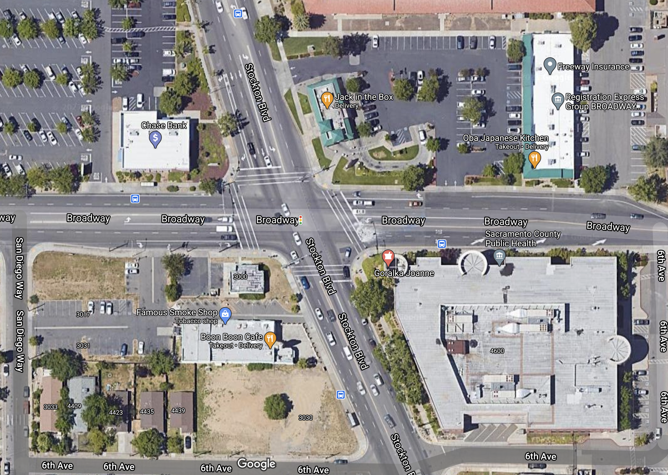
I’ve picked the intersection of Broadway and Stockton Blvd in southeast Sacramento as an example. It is certainly not the worst intersection, but it shows several of the scenarios for bike lanes.
First, an excerpt from the Sacramento Bicycle Master Plan 2016-2018 map showing existing and proposed bicycle facilities. Broadway has Class 2 bike lanes from 44th Street through 49th Street, including the intersection. Stockton has Class 2 bike lanes south of Broadway, but only proposed Class 2 bike lanes north of Broadway.
Broadway & Stockton Blvd, bicycle facilities from Sacramento Bicycle Master Plan
Second, a Google Maps excerpt of the intersection.
Broadway & Stockton Blvd, Google Maps
Southbound on Stockton Blvd, there is actually a bike lane between the through lane and the right hand turn lane. This is the type of facility that scares many bicyclists, riding between two potentially fast lanes of traffic. If you assume that the turn lane if inevitable, which it is not, then this is the only way to place a bike lane without significant intersection modification. Southbound on Stockton, there is no bike lane before this short bike lane shows up.
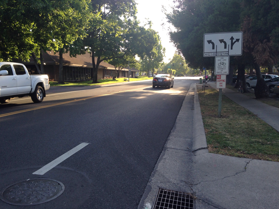
Northbound on Stockton, the bike lane is dashed from 6th Avenue to Broadway. The dashing, or skip line, is intended to indicate to both bicyclists and drivers that this is a merge area, with right-turning traffic merging to the right and through traffic merging to the left. Problem is, almost no drivers know what this means and how to act. California Vehicle Code (CVC) requires that a right turn be taken from the rightmost position (CVC 22100: Both the approach for a right-hand turn and a right-hand turn shall be made as close as practicable to the right-hand curb or edge of the roadway…). The purpose of this law is in part to ensure that bicyclists and drivers are in line with each other, so that the bicyclist is not right-hooked by the driver. In the turns section of the DMV Driver Handbook, none of the diagrams or text mention bike lanes, so it is not surprising that most people are unaware of the law and do not follow it.
Eastbound on Broadway, there is a bike lane present up to San Diego Way, the preceding street, but is absent in the next block. It is dropped in favor of a dedicated left turn lane and a dedicated right turn lane. Many bicyclists will ride the left edge of the right hand turn lane, and then proceed through the intersection. But most bicyclists will not even ride here because it is uncomfortable and unsafe. The bike lanes on Broadway are largely wasted because of this dropped bike lane. If a person doesn’t feel safe approaching an intersection, they don’t feel safe on their ride.
East of the intersection, the bike lane does not start up again until just past 6th Avenue. What the bicyclist is faced with is no bike lane in an area where two general purpose motor vehicle lanes are merging, which is a situation in which drivers are negotiating with other drivers, not paying any attention to bicyclists. There is a simple solution here, which is to make the right hand lane approaching Stockton be a right-turn only lane, so that the merge happens before the intersection, not after. That also removes the need for the existing right hand turn lane and provide space for a bicycle facility. To the east of the intersection, Broadway would be one lane only, as it becomes just one block later.
Westbound on Broadway, there is a bike lane from the east, but it is dropped 180 feet before the intersection, in favor of a right hand turn lane.
This is a flared intersection, where the roadway cross-section is wider near the intersection than on the approaching streets. The reason for this is to accommodate turning lanes. Stockton southbound has dedicated right turn and left turn lanes. Stockton northbound has a dedicated left turn lane. Broadway eastbound has dedicated right turn and left turn lanes. Broadway westbound has dedicated right turn and left turn lanes. Despite the flare, bicyclists have not been accommodated, only motor vehicle drivers.
Northrop Avenue dropped bike lane, Sacramento County
I believe strongly that bike lanes should not be dropped at intersections. Never. Ever. As I’ve noted before, I’m a vehicular bicyclist who is not significantly affected by these roadway design flaws, but it is not for vehicular bicyclists that roadways should be designed. They need to be usable and comfortable for the widest possible array of bicyclist types (Four Types of Transportation Cyclists).
The perceived need by traffic engineers and drivers for dedicated turn lanes should not trump the actual needs of bicyclists for continuous and safe bicycle facilities.
It is possible to modify or reconstruct intersections so that they accommodate drivers, including turn lanes, and bicyclists, with continuous bike lanes, but that is expensive, and such changes would happen only slowly. What needs to be done NOW is to return a small part of the roadway to bicyclists by ensuring that bike lanes continue up to and through intersections. That means restriping the roadway to reallocate space. Either right turn or left turn dedicated lanes would need to be removed. I’ll leave it to the traffic engineers to decide which maintains the best flow of traffic, but I won’t leave it up to the traffic engineers to decide that it doesn’t need to be done. Though I don’t like, and most bicyclists hate, bike lanes between right turn lanes and through lanes, it is one possible solution for maintaining the right turn lane, but only when right turns are a predominant movement for the entire intersection.
Note: This is not just an issue in Sacramento. It is in the county, and the region, and the state, and everywhere in the US that I have traveled. In Oregon, bike lanes continue to the intersection, but then Oregon has the strange idea and law that bicyclists need to remain in the lane, but drivers can’t enter it. I’m not sure whether this is more safe or less safe, but it is different.
The City of Sacramento implemented the first three Slow & Active Streets on Friday. Eleven blocks of 26th Street, four blocks of O Street, and five blocks of V Street were designated. Apparently these streets were selected based on strong support from the Midtown Neighborhood Association.
These streets are not closed to motor vehicles, this is not an open street type designation, but through traffic is discouraged. The signing below is on 26th Street at S Street, and every block is marked with signing, though some blocks are simpler. The signing is always set to the side, in what would be the parking lane. This is different from the setup used by almost all other cities that have set up slow streets, where drivers have to carefully go into the opposing lane in order to proceed on the street. The signs are less likely to be damaged, which is a problem in some cities where belligerent drivers move or simply run over the signs, and where errant drivers cannot help but hit anything in the roadway, no matter the safety colors used. But they are also less likely to be noticed.
26th Street at S Street, Slow & Active Streets signing
I watched two intersections on 26th Street for some while, and I saw not a single driver avoiding continuing on or turning onto 26th Street because of the signing. This may change over time as people get used to it, or it may not. It is, after all, a pilot. If you walk or bicycle on these Slow & Active Streets, or live on them, please let the city know what you think and what you observe, at https://forms.cityofsacramento.org/f/PW_Transportation_CommentForm.
The city has said the Slow & Active Streets program will be in effect at least through the end of April, but that may be extended to the end of June. Some additional streets are under consideration. The city has said that primary limiting factor for the pilot is the requirement that the signing be checked every day by Public Works staff, and after April these staff will be busy with other tasks. I am sure that local resident can take care of most needs, and report to the city if there is something they cannot fix, but I don’t see a need for staff to check them any more than once a week.
My earlier post on corner retail was in preparation for talking about an idea that corner retail should be acknowledged, supported, and promoted in the upcoming Sacramento 2020 General Plan. The general plan tentatively promotes higher density by allowing a reasonable floor area ratio for properties throughout the city, while removing development constraints that add nothing to safety or livability. Assuming the plan and the resulting code to support it does significantly increase the number of homes and people able to live in the city, if the city remains as car-centric as it is, the result will just be less parking availability and more congestion (both of which I’m in favor of, but I recognize most people are not). It would go towards solving the housing issue, but do little for livability and climate change issues.
So what is the solution? A place where people can perform most of their daily activities without driving. In other words, corner retail. The jobs issue is a separate one, though corner retail would also increase the number of jobs within walking distance.
Karma Brew, my neighborhood bar, on the corner of P St & 16th St, 2-1/2 blocks from my house
I am not sure exactly how to accomplish this, but I’ll throw out an idea. I don’t think rezoning corner lots from residential to commercial is necessarily the answer, because that might encourage entirely new buildings replacing existing buildings. Obviously many existing buildings would need to be changed to serve as retail, but I don’t think wholesale replacement is good, and it is not respectful of that claim of ‘neighborhood character’ (which is often a cover for concerns not voiced, but is nevertheless a consideration).
Rather, I think a by-right conditional use permit (is that an oxymoron?) is the better solution. That way the building remains similar to what is there now, but becomes functional as a retail location.
Where? I’m partly of mind to say everywhere, every corner. Much of the existing corner retail predates zoning (grandfathered in) or is already under a conditional use permit. But I’m also of mind to limit it to fewer locations, which would be any corner fronted on at least one side by a collector or arterial street. In the lower density parts of Sacramento, I don’t think much corner retail would show up, because it takes a certain density to make retail viable, but there would certainly be more than there is today. Wouldn’t you like to be able to walk to a coffee shop in your neighborhood. Or walk to the market for a few items?
Note that I’m not clearly defining what corner retail is. Does it mean there is only one business present, or allowed, or could it be a few small footprint businesses clustered together? Some of the locations I’ve identified are not on actual corners, but they have the feeling of corner retail. The general plan and the supporting code would have to define corner retail.
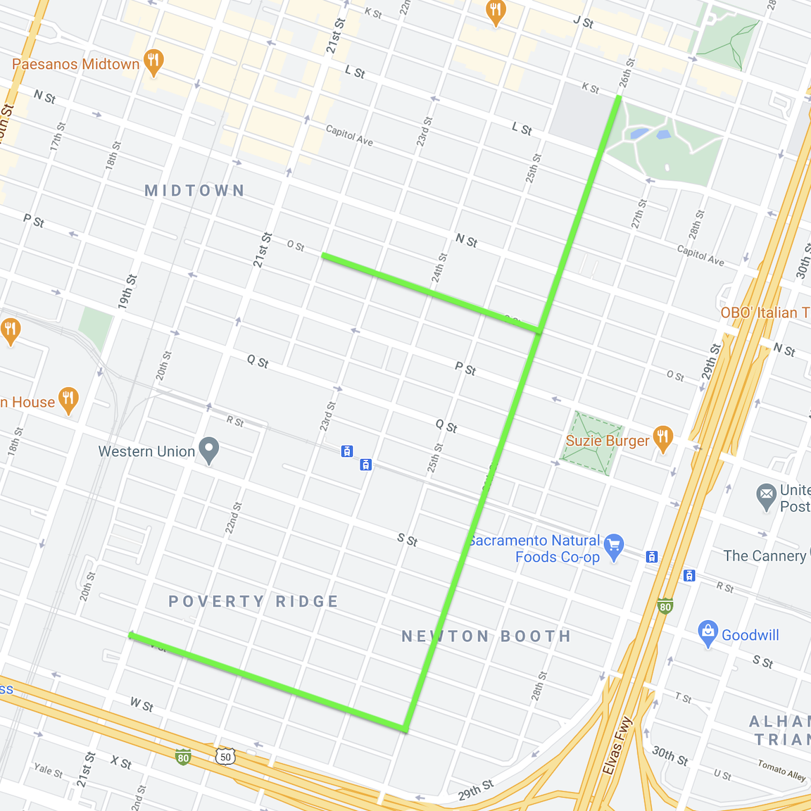
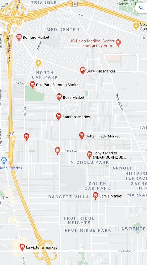
Below are two maps of Oak Park, on the left, arterials and collectors, and on the right, GoogleMaps with markets selected. The scales are similar but not identical. As you can see, some corners on arterials or collectors already have corner markets, and there are other corners with retail that is not a market, but there are a number of locations that could have corner retail under my proposal, but do not. I picked Oak Park just because I’d spent time there recently looking for markets and other corner retail (photos below).
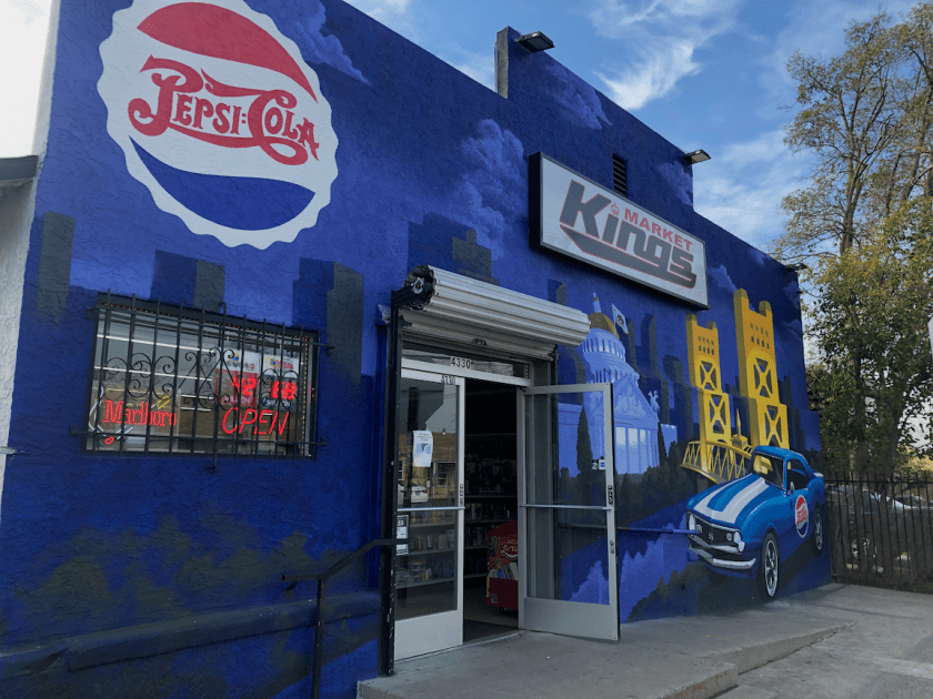
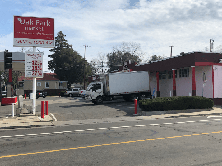
The slideshow below shows some of the corner retail, mostly markets, in Oak Park. Note that in general these locations are much more car-oriented than the ones I showed in the central city, because the area is much more car dominated. I will say more about that in the future. It does not include the many, many businesses that are part of commercial zones along Broadway and Martin Luther King. If you zoom in on Google Maps, a commercial area overlay shows up as pale yellow. I am gradually collecting photos of retail in other areas of Sacramento and will eventually post them.