Update 2023-06-19: There are now many more Bird bikes than last week, so it seems to be part of a major deployment. I’m not on Bird’s email list, perhaps they have provide some info through email. I rode a Bird bike twice. They handle differently from the Lime/JUMP bikes, so as with any bike that is new to you, start out slowly until you get accustomed to it. The bikes have a digital speedometer, and they are the 15 mph limit that the city agreement enforces. They have swappable batteries, similar to but not the same at the Lime bikes. I did not ride through any of the slow or no parking zones, so don’t know if Bird has the same as Lime.
Bird Bikeshare bikes in Sacramento
I noticed this morning that Bird Bikeshare bikes have shown up in Sacramento. The ones I saw and show up in the Bird app are in midtown, though there may be ones elsewhere. Bird devices are primarily in the central city of Sacramento, with some further out and in West Sacramento. After selecting a device, the use boundary shows up, a light blue background outlined with a blue line. Though it is more detailed, it is generally east to Power Inn Rd/Howe Ave, south to Fruitridge Rd, west to ship channel in West Sacramento, and north to El Camino Ave.
The app does not seem to have the ability that the Lime app does of selecting for just bikes or just scooters. Since the scooters are far more common, they may cover up the bike icons, and you will have to scroll around and zoom in to find bikes.
Bird has a community pricing membership for low income riders in Sacramento, 50% off rides. The access program with a low cost membership and limited free rides is not yet available in Sacramento. Bird bikes and scooters are $1 to rent and $0.49 per minute. There also seems to be a promotional 25% off.
Lime bikes, after a period of being better maintained, seem to have declined again. I rented five bikes today, and only one of them was in decent shape. All the bikes have been crashed, once to multiple times. Bent wheels, bent handlebars, loose seat posts, single gears (the old red Lime/JUMP bikes are supposed to have three gears, where as the newer white/green bikes have variable responsive gearing). I know riders are crashing bikes, mostly when drunk, but I also wonder if Lime is dumping damaged bikes into Sacramento.
The City of Sacramento Climate Action and Adaptation Plan (CAAP) draft has been released. Note that this is the second draft, though essentially unchanged from the first draft. I reviewed my previous posts on the CAAP (category: CAAP) and looked a a few key places in the plan to see what had changed. Nothing.
City staff gave a presentation on the CAAP to the ECOS Climate Committee last night. As with all previous presentations, and the plan itself, the focus was on SMUD zero-carbon (which the city shouldn’t really be taking credit for), electrification of built housing, and EVs. And EVs, and EVs.
57% of Greenhouse Gas emissions (GHGs) are from transportation, so it certainly makes sense that electrification of vehicles is important. However, the the city’s focus on EVs ignores: 1) all the city can do is provide charging, all other aspects of the transition are largely beyond their control; 2) the transition will be slow, and there will be fossil fuel vehicles on the road long after net-zero is intended; 3) it turns out EVs are not the environmental panacea claimed, with battery manufacture, rare earth mining, and battery recycling (or lack thereof, turns out almost no batteries are being recycled); 4) EVs are not and will probably never be affordable to low income people, and nearly all the subsidies so far have gone exclusively to high income individuals; 5) EVs have the same or worse pollution potential as fossil fuel because the main health impacts of motor vehicles are not tailpipe emissions, but road dust, tire dust, and brake dust, which are all exacerbated by the higher weights of EVs; 6) EVs kill pedestrians and bicyclists just as effectively, if not more (higher weight) than fossil fueled cars.
On Wednesday afternoon, the sign below was on 21st Street approaching I Street. The sign was not there on Tuesday morning. If a bicycle signal was intended at this intersection in the design, why was it not signed earlier? Why wasn’t the signal already installed, since there was signal communications infrastructure installed at this intersection several weeks ago? Or was this a design oversight that the city decided to fix after being called out on it? And when is ‘coming soon’?
21st St at I St, sign for future bicycle signal
I observed bicyclist behavior at this location for a while on Tuesday. Every single bicyclist who was headed north on 21st Street crossed against the red light, so as to not be hit by left turning drivers who generally do not yield to anyone in the crosswalk, and then onto the sidewalk on the west side of the street, continuing through the area at Old Soul Weatherstone which is congested with tables and walkers. So the city has trained bicyclist to ride on the sidewalk. Those who have been so trained will be likely to continue sidewalk riding even after installation of the signal. Ouch!
Useless Turn Wedges
I have ridden 21st Street a number of times, to see how the project is progressing and to see how drivers are responding to the new layout. Most drivers are parking correctly in the parking that provides parking-protection for the bikeway, but a few continue to park against the curb. I’ve reported these to 311 for parking enforcement, but of course as always, parking enforcement reports that the vehicle is no longer there, whether it is or not.
Several times in a row drivers have turned across my path at high speed, left from 21st Street to L Street, over the green paint and the white turn wedge paint. At the times of day I was there, there were few to no parked cars, so I was clearly visible to the drivers, not in any way hidden. In both cases I had to slam on my brakes to avoid being hit by the drivers. They did not slow. The turn wedge diagram provided on the Central City Mobility Project page, shown below, clearly shows bumps and posts (vertical delineators) in the wedge. Without more detail, I can’t say whether these will actually affect driver behavior, but in general only hard curbs or real bollards (steel or concrete) actually affect driver behavior. In the meanwhile, drivers are being trained to turn across bicyclists, with impunity, and will not likely change their behavior when and if something is installed in the turn wedges.
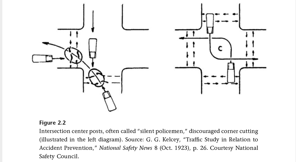
I have been reading Fighting Traffic by Peter Norton, and in Chapter 2 he introduces the concept of the outside left turn, which worked to prevent drivers from cutting the corner on left turns, and was later enforced with ‘silent policemen’, hard structures that provided serious consequences for drivers who insisted on cutting corners. Later, when motor vehicles were given dominance on the roadway, these were removed. It is time to bring these back!
Other
Striping and green paint is very nearly complete on 21st Street. 19th Street has been repaved and preliminary marking installed (the dashed white lines). P Street was just stripped for new pavement (I’m not sure what this process is called, removing 2 to 3 inches of old pavement so that new pavement can be laid), and is being repaved today (Thursday). Q Street has been patched but not stripped. I’m not noticing any active work on I Street, 5th Street, 9th Street, or 10th Street, though I Street has had ‘no parking’ signs up for some while.
The repaving is being done to the full width of the roadway, including the parking lane. This is a waste of materials and money. The parking lane does not need to be repaved, except in a few circumstances where it has been damaged. Nor does it need to be paved to the same standards as the general purpose travel lanes, which receive far more traffic and wear and tear. But the city loves pavement, and loves to add on unnecessary work to projects, ensuring that less is left for actual improvements to the street that would help walkers and bicyclists.
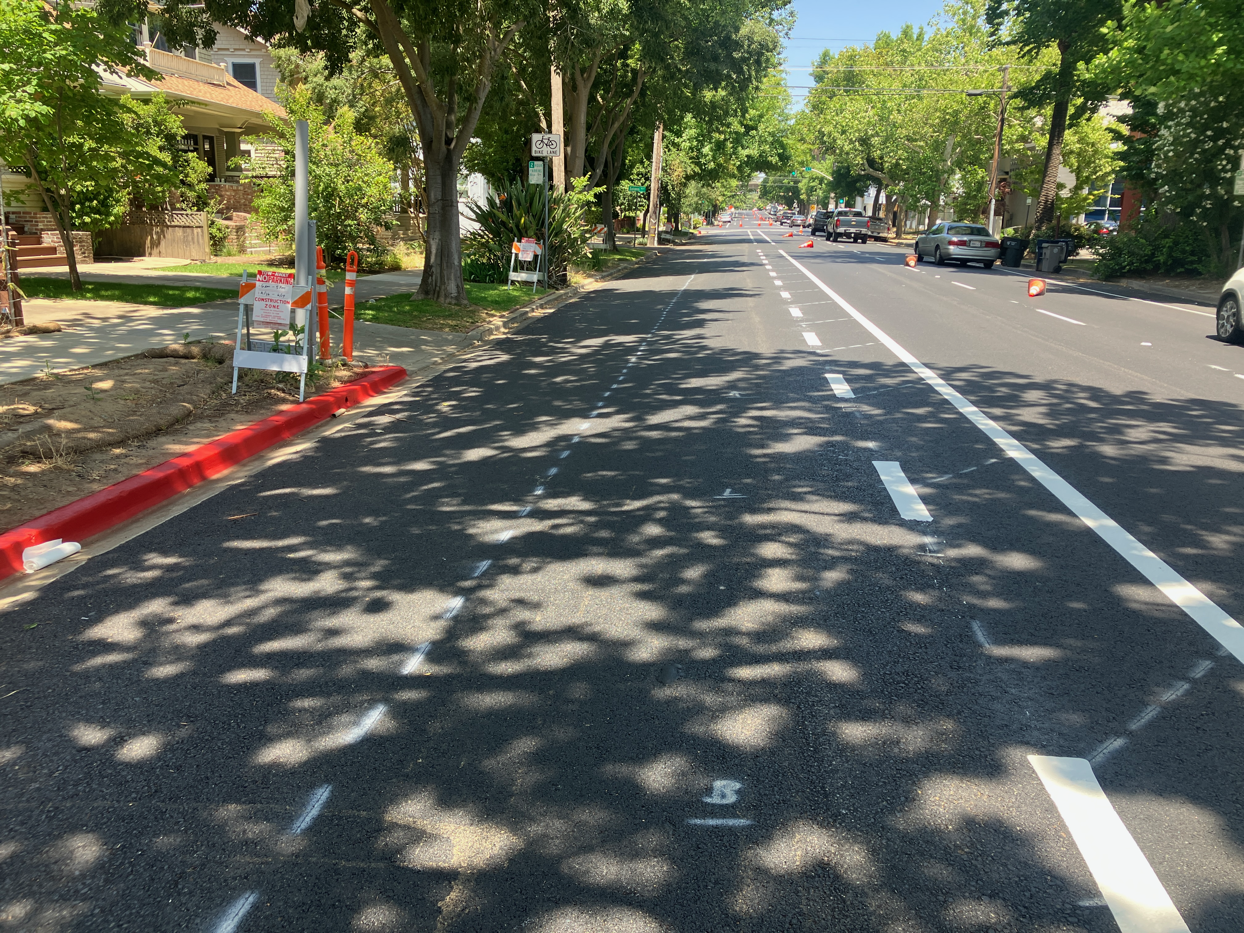
The separated bikeway (protected bike lane) and repaving is mostly complete on 21st Street in Sacramento, part of the Central City Mobility Project. Almost all the white striping and green paint is complete. No vertical delineators (soft hit posts) yet. When I rode the street a few days ago, most vehicles were parked in the correct location in the parking spaces separated from the curb. There are two blocks where the bikeway is adjacent to the travel lane, and parking adjacent to the curb, between T Street and S Street, and between N Street and Capitol Ave. There is no obvious reason for this.
The beginning of the left side separated bikeway at W Street is marked oddly, see photo below. The arrow in the green turn box would imply that one should immediately turn onto 21st Street, when it should indicate to cross 21st Street the the bikeway on the other side. The shadow shows the correct move.
21st Street at W Street, green turn box with incorrect arrow
The ‘turn wedges’ noted in a an update post are is far only white paint, nothing that would prevent a driver from cutting the corner across the bikeway area. In fact, I observed several drivers doing just that.
21st St at T St turn wedge
The big concern is where the separated bikeway approaches I Street. The bikeway is on the left. Travel lanes are in the middle, one left turn only and one combined left turn-through-right turn. I Street becomes one-way westbound at this point, is two-way to the east, and 21st Street is two-way. Before repaving, the left side bike lane had a left turn arrow. The right side bike lane that was there before repaving is not there now, and it isn’t clear that there is intended to be. There is no warning that the separated bikeway ends at I Street, and no bike facility for transitioning to the right side to continue north on 21st St. This would be a good location for a bicycle signal to allow bicyclists to continue through the intersection on a bicyclist-only phase.
As mentioned earlier, the draft City of Sacramento 2040 General Plan has been released. For transportation advocates, the two most important chapters are Chapter 3: Land Use and Placemaking and Chapter 8: Mobility. Land use and transportation are so closely tied that I’m a little confused at to why the city separated them into separate chapters. Though the text which introduces each chapter (element), and each Goal and Policy section within the chapter, often refers to other parts of the plan, it seems to me that they were written independently and linked after the fact.
Element 3, Land Use and Placemaking, has the following sections:
Land Use Framework
Integrating Infill Development
Thriving Commercial Mixed-Use Centers
Complete and Inclusive Neighborhoods
Industrial Areas
Placemaking, Green Building, and the Arts
Element 8, Mobility, has the following sections:
A Multimodal System
Reduced Reliance on Single-Occupant Vehicles
Safety
Regional Connectivity
Supporting Goals through Data, Technology, and Innovation
There are a number of organizations taking deeper dives into the General Plan draft, and I encourage you to join one of them:
there are not doubt others; ask your organization what it is doing
Or, if you have the time, do your own deep dive. Of maybe transportation and land use are not your focus, there are seven other areas that may interested you.
Though the General Plan is not really a legally binding document, it is a tool that advocates can use when asking the city ‘why aren’t you doing this?’ or ‘why are you doing this?’. So it is important that the final plan reflect the desires of the citizens, and the reality of climate change and lack of equity.
You can expect more posts on the General Plan, as I have time to look into the details.
There are a number of things the City of Sacramento could be doing to better manage parking: Parking reform for Sacramento. But perhaps the most important is removing parking mandates, those city regulations that require developers to put in parking whether it is needed or will be used, or not.
The city council in January 2021 adopted the Proposed Roadway Changes document that had been recommended by staff working on the 2040 General Plan update. This is a very large document, so the relevant section on parking is excerpted. It states, in unequivocal terms:
10. Eliminate City-mandated parking minimums citywide and introduce parking maximums.
City of Sacramento, Council Report 15, 2021-01-19, 2040 General Plan Update – Draft Land Use Map, Proposed Roadway Changes, and other Key Strategies
Here we are, about two years later, and the staff is recommending considerably less in the draft plan, that action ‘could include’. Not will include, not studied on a timeline, not implemented, but maybe we will think about it, if we get around to that. Could that city have come up with any more vague and unserious language?
M-2.17 Parking Management Strategy. The City shall continue to deploy a parking management strategy that optimizes the use of existing supply, minimizes the need for the construction of new parking facilities, and promotes the use of active modes of transportation, public transit, and highoccupancy vehicles. Program components could include the following:
Adjusting parking management strategies based on goals and needs;
Adjusting parking meter hours and pricing for effective management;
Eliminating City-mandated parking minimums;
Implementing parking maximums along established transit corridors;
Allowing unbundled parking in conjunction with strategies to reduce the need for private automobiles;
Incorporating or facilitating technology such as smart-phone apps and wayfinding signage that direct drivers to open parking spaces in real-time, automated and/ or stacked parking systems, or parking technologies that improve parking efficiency in mixed-use centers and corridors;
Supporting the use of alternative modes by providing alternative programs in lieu of monthly parking passes and discounts; and
Improving branding, communications, and wayfinding signage.
City of Sacramento, draft 2040 General Plan
It should be noted that the General Plan language implies that the city has a parking management strategy, or a parking management plan. So far as the public knows, it does not. So the city is referencing something that either does not exist or has never been shared with the public. The first thing that the General Plan must include is a commitment to developing a parking management plan, with public engagement, and then sharing the plan with the public. The plan does not even mention this.
This is a typical car-brained response to solve an issue. While it is true that a car trip to the airport has a fraction of the carbon impact that your flight has, nevertheless, it is possible to get to the airport without touching a car, your own or ride-hail.
SacRT has Route 142, once an hour, and Yolobus has Route 42A/42B, once an hour or better. Though the schedules are not fully integrated (yet), this results in about 30 minute service frequency to and from the airport. SacRT’s buses are electric, and take about 20 minutes for a trip from downtown to the airport, without stops, while Yolobus’s are fossil fuel, and take about 20 minutes for the trip, downtown Sacramento to the airport. The clockwise/counterclockwise loop buses also serve Davis and Woodland.
You can plan your trip with Google Maps or the Transit app (highly recommended).
How much does it cost? SacRT $2.50 per ride (and 90 minute transfer) or $1.25 discount, or free for K-12 students. Yolobus $2.25 or $1 discount. Compare that to parking at the airport, $2/30 minutes, with a maximum of $10/day up to $30/day. Ride-hail? $30 to $168, depending on time of day and surge pricing, according to the Bee article. Want to throw your money away for perceiving convenience? Go ahead.
So, get out of your car, or anyone’s car, and on to the bus. And leave your car-brain behind.
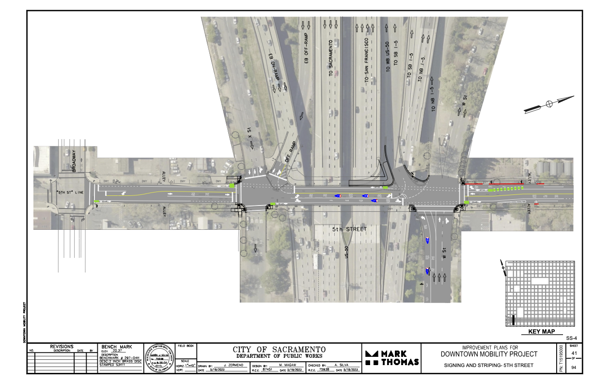
I had earlier expressed concern and lack of information about where the 5th Street one-way to two-way conversion will be handled where 5th Street passes under Hwy 50. (Yes, I know, that this is technically not Hwy 50, but everyone thinks it is, so…)
The following diagram was provided the the city and design firm (pdf). The configuration looks workable, and it probably not any less safe than the current mess. The merging of the two on-ramps into one narrower entrance will probably help to slow traffic entering the freeway, making 5th Street a bit safer. Same with the narrowing of the off-ramp. The curb line will need to be moved in a few locations to accommodate the entire street width with bike lanes, but the curbs here are already quite deteriorated, so that work would be needed in any case. It is not clear from the diagram whether the missing sidewalks in the block between Broadway and X Street will be corrected.
Electric vehicles (EVs) are touted as being the solution to many of our climate change problems. Most of the money being spent on climate change current is going to EV subsidies and to creating widespread charging networks. They also dominate the conversations about climate change, pushing other issues and solutions to the margin. I’m sick of this (I’m tired of the electric vehicle conversation), and become more sick by the day. They are only a small part of the actions we need, and they should not be receiving the bulk of the funding.
The hype and commitment to electric motor vehicles also pushes out the real climate solution (and livability solution), electric bikes, whether privately owned or bike share systems. Entities from the city to the county to the state to the federal government claim that there isn’t enough money to really support the transition to elective bikes. Why? Because almost all of it going to EVs.
If we depend on EVs to solve our environmental or social problems, we’ll will end up with exactly what we have today, which is world dominated by motor vehicles and traffic violence. Except it will be worse, because we’ve put all our eggs in one basket.
Paris Marx in Road to Nowhere: What Silicon Valley Gets Wrong about the Future of Transportation, addresses the boosterism in Chapter 3: Greenwashing the Electric Vehicle (ISBN 978-1-83976-588-9). Conservative magazine Forbes offers The Expensive And Harmful Truth About Electric Vehicles. Volt Rush: The Winners and Losers in the Race to Go Green (ISBN 978-0861543755) covers the mining and battery manufacturing side of electric vehicle production. If you search the Internet, you will find articles and sources ranging from ‘EVs are the single solution to everything’ to ‘EVs will be the end of us all’. The truth, is of course, somewhere in between. It is early enough in EV adoption that we really don’t know that much about overall and long-term effects. Nor is there an effective battery recycling industry yet (though it is not hard to find dead Teslas, with their batteries waiting to be recycled).
Much of the Inflation Reduction Act and Infrastructure Investment and Jobs Act, as well as other federal investments, is going to subsidizing the purchase of electric vehicles, and creating charging networks. As is well known, almost all the existing EV subsidies at the federal and state levels have gone to high income individuals. Little in the current and planned programs will change that. Though there is work to make subsidies more equitable, every proposal has met with significant blowback. The rich want to preserve their perquisites.
I suppose the thing that most irritates me personally is the ‘more environmental than you’ attitude of Tesla owners. They live, though not speak, as though their purchase of a Tesla has absolved them of all other environmental harms. Tesla owners are part of the ‘I’m richer than you, so I can do anything I want, and I can drive in any way I want’ crowd. For more on Tesla the real instead of Tesla the hype, see Ludicrous: The Unvarnished Story of Tesla Motors, Edward Niedermeyer, ISBN 978-1948836128.
My greatest concerns about EVs are:
all cities and counties can do is provide charging, all other aspects of the transition are largely beyond their control; this sends the locus of control to a higher level of government, further from people
the transition will be slow, and there will be fossil fuel vehicles on the road long after net-zero is intended
it turns out EVs are not the environmental panacea claimed, with battery manufacture, rare earth mining, and battery recycling (or lack thereof, turns out almost no batteries are being recycled)
EVs are not and will probably never be affordable to low income people, and nearly all the subsidies so far have gone exclusively to high income individuals
EVs have the same or worse pollution potential as fossil fuel because the main health impacts of motor vehicles are not tailpipe emissions, but road dust, tire dust, and brake dust, which are all exacerbated by the higher weights of EVs
EVs kill pedestrians and bicyclists just as effectively, if not more (higher weight), than fossil fueled cars
Why this topic today? Because I’m about to get to some posts on the City of Sacramento Climate Action and Adaptation Plan. The plan prioritizes EVs in its solutions to GHG reduction. Ack!
Note: Info on 9th Street and 10th Street added below.
For other posts on the City of Sacramento Central City Mobility Projects, see category: Central City Mobility Project. I’m not sure how interested readers are in my minor updates, but I think it is fascinating to see how the city is repurposing street right-of-way, solving problems (or not), and what is being prioritized in the overall project. I’ve not seen any signs of construction on P and Q streets, other than the ADA ramp work that has been going on for several weeks.
Turn Wedge
The project page has a diagram that I had not exactly seen anywhere before, the corner wedge, below.
Central City Mobility Project diagram turn wedge
I saw a location marked for a turn wedge yesterday, at 21st St and O Street, southwest corner, below. This is a little bit like a corner of a protected intersection.
Sac_21st-St-O-St-SW_turn-wedge
5th Street Two-Way Conversion
I looked at the length of 5th Street, from Broadway to I Street. I still have no insight into what will be done under Hwy 50 where there is a one-way block that is closely tied to the freeway onramps. I have requested clarification from the city but they have not answered yet. I’ll update when I hear.
Signal bases have been installed for new signals from W Street to N Street, but not north of there. Active work was going on at N Street. At R Street, it looks like the existing pedestrian flashing light will be duplicated for the other direction. This is not a full signal, nor a user-activated signal, but always on.
Between Broadway and X Street, 5th Street is two-way, four lanes, with sharrows marked (and very faded) in the outside lane. Sharrows are no longer considered valid bikeway markings, so presumably there will be marked bike lanes here. There are three very-wide blocks for 5th Street, from N Street to L Street, and from J Street to I Street. From N to L, there are two through lanes and one or two left-turn lanes, plus parking and bike lanes. From J to I, there are two through lanes and two left-turn lanes, plus parking left and right and a bike lane on the right.
On the west side of the intersection of 5th Street and I Street, there is a crossing prohibition. I hope that the city removes this prohibition as part of the project. In most cases, freeways onramps and off-ramps being an exception, crossing prohibitions are an attempt by the transportation agency to prioritize motor vehicle volume and speed over all other considerations. They are morally wrong, and should be legally wrong.
Sac_5th-St-N-St_extra-wide
I Street Separated Bikeway (and lane reduction)
Some work has started on the I Street separated bikeway, which will run from 21st Street to 12th Street (see the importance of I Street for why it should continue west). Most corner ramps were already ADA compliant, but the few that were not have either been upgraded or are in progress. Fabric covers have been set up over drain inlets, and temporary no parking signs line the street, so I assume repaving will occur soon. I don’t see any indication of whether the separated bikeway will be on the right side or left side of the street. I Street does not have SacRT fixed route bus service, which engenders left side bikeways, though there is some commuter bus service on the street.
The project map indicates that I Street will be “lane reduction and separated bikeway”, not parking protected separated bikeway, so this will be a different configuration than 19th Street and 21st Street.
I will be interested to see if the city will address the lack of sidewalk on the south side of I Street between 16th and 15th, where the city installed a loading dock for Memorial Auditorium in place of the former sidewalk. I strongly believe that removal of sidewalks, as was done here, are criminal (Sac permanently closes sidewalk).
19th Street Repaving
It looks at though 19th Street is not going to be completely repaved in the way 21st Street was, rather, it is getting spot repaving. I don’t know whether there will be an overlay so that the new marking are on a fresh blank canvas.
9th & 10th Street Parking Protected Separated Bikeway
The 10th street parking protected separated bikeway will be extended from Broadway to Q Street. The block of Q Street to P Street has a buffered bike lane, outboard of parking in the south half, and without parking in the north half, and since that block has recently been changed, it will likely stay that way. There is a buffered bike lane from Q Street to L Street, and then a parking protected separated bikeway of variable quality from L Street to I Street. There is no bus service on 10th Street, so the right side configuration will probably be maintained throughout.
10th Street is relatively wide under Hwy 50, so no special treatment here will be needed.
On 10th Street there are ADA ramp upgrades at several locations, and several more haven’t started yet. The street has a lower rate of ADA compliance than many central city streets. There is no indication of roadwork yet.
The 9th Street parking protected separated bikeway is being extended south from L Street to Q Street. There is no indication of any sort of work here yet. Most corners already have compliant ADA ramps. There is construction on the east side of 9th (right side southbound) between L Street and Capitol Mall, and on the west side (right side southbound) between N Street and O Street, and between P Street and Q Street. All of these construction projects will probably be going on for quite some time, and this may be the last street to be modified. SacRT Bus Route 51 runs on 9th Street south of Q Street to Broadway, which is outside this project scope, but presumably argues for keeping the left side bikeway configuration throughout.