Community meeting on crosswalks – 2

Part one, Community meeting on crosswalks, prior posts:  removal of crosswalksDon’t use the ‘A’ word. Next related post will be about Zegeer.

Question and answer session of the meeting:

  • The city is doing a speed study on Freeport from Sutterville Rd to Meadowview Rd, and will include part of Sutterville (not clear what part)
  • There are no red light cameras on Freeport; the city piggybacks on country red light program
  • There are no lead pedestrian interval signals on Freeport, or even is south Sacramento (all are in the central city); Ryan Moore said these should not be used in low pedestrian areas (which is false)
  • Resident commented on Fruitridge Rd, 24th to Freeport, a lot of red light running and few safe crossings
  • Resident who lives on Oregon suggested changing the speed limit on Freeport
  • Steve Hansen says that the city would like to change Freeport, but to do so, the community (residents, businesses, neighborhood associations) will need to come together to decide how; people will have to give up some time for better safety; he also mentioned narrow sidewalks with obstructions
  • Several people asked about or commented on specific sections and intersections; Matt mentioned catching egregious speeders
  • South Land Park Neighborhood Association (Ryan?) asked what public notice there was before crosswalk removal and said they were not notified; not clear if the other two were notified
  • Ryan Moore said that each removal was analyzed, he says they followed the law of CA MUTCD; said most of the removals were result of complaints; said neighborhood input makes no difference; mentioned FHWA info on crosswalks, referring to Zegeer report though not by name (more info about Zegeer in a future post)
  • Neighbor said that any process that removes crosswalks is flawed; mentioned no still phase on signals (time between red one direction and green the other); going out of the way is not reasonable to ask; can’t have data on people walking because people are scared to walk
  • Steve Hansen and Jay Schenirer want to review pedestrian guidelines, not sure what document this is; said we need to talk about equity because the top corridors of Vision Zero concern are not necessarily located in disadvantaged communities
  • Neighbor said speed display signs don’t seem to have any effect on behavior; asks for immediate action and not years out
  • Ryan Moore continually says “we’d like to but we can’t” but offers no proof; continues to say that crosswalks at this volume and speed are not safe
  • Neighbor said there are bus stops close to Oregon which is true and which might make removal a violation of Title 6
  • Issue of sidewalk maintenance responsibility has come up several times; city continues to insist that it is the responsibility of the property owner (even though most sidewalks are part of the public right-of-way and all are part of the transportation network)
  • Many people pointed out that improvements could have been made at the Freeport-Oregon intesection, such as bulb-outs, refuge median, lighting; there is a median already but it is too narrow to provide refuge
  • Participant asked for a pedestrian commission, Jennifer Donlon Wyant said the the city Active Transportation Commission would be seated in April or May
  • Jay Schenirer wrapped, mentioned that McClatchy students drove the changes to Freeport north of Sutterville Rd

My overall take on the community meeting is that the city council members and the public, both residents of the neighborhood and others, want proactive changes to increase pedestrian safety and walkability. They don’t want excuses. Ryan Moore, the Interim City Traffic Engineer, seem prepared only to offer excuses.

Of all the people on stage, Ryan Moore seemed the least sympathetic to the person killed, or the issues that it raises. He said much the same thing he’d said to the SacBee: “Instead, traffic engineers hope that by removing some crosswalks, pedestrians will instinctively choose to cross at a safer, nearby intersection,” Moore said. He kept referring to federal and state standards that were being followed, though a number of people in the audience who know a great deal about traffic engineering noticed that he was mis-stating and mis-using standards and research to defend his actions and opinions.

Community meeting on crosswalks

I had promised I’d report on the community meeting to address the crosswalk removal over Freeport at Oregon and related issues, but it has taken me a while. Previous posts: removal of crosswalksDon’t use the ‘A’ word. For background, see the SacBee article: Why Sacramento erased 23 crosswalks, including one where a grandmother died after removal.

The meeting was hosted by City of Sacramento council members Jay Schenirer and Steve Hansen, and school board president Jessie Ryan, and held March 8 at Hollywood Park Elementary which is east of the intersection where the fatality occurred.

Steve talked about the concept of a stroad, a street/road hybrid that doesn’t do either well, though he did not use the term. Freeport is a stroad. He introduced vision zero, talked about changing both infrastructure and behavior, mentioned that the traffic motor officers are gradually being built up but are far below what they should be, and said “we should enjoy the public space and not be afraid.”

Ryan Moore, Interim Traffic Safety Engineer, and the person responsible for the removal of crosswalks, repeatedly mentioned a ‘Systematic Safety Analysis Report’ but is was not clear what this is, and the city website has no mention of it. He also said that he was following all the federal and state rules, as well as research, by removing the crosswalks.

Jennifer Donlon-Wyant, the Active Transportation Specialist, gave a Vision Zero presentation similar to what many people have seen before, but highlights are that Sacramento is the second worst in the state for pedestrian fatalities per capita. She went over the ten profiles that are the core of the draft Vision Zero Action Plan, of which three are related to speed, and one related to transit stops, which all play a role in this incident. One that does NOT apply is ‘Pedestrian Crossing Outside of an Intersection or Crosswalk.’ Though the city had erased the marked crosswalk, it was and is still a valid legal crosswalk. Freeport Blvd is not one of the top five fatality and injury corridors in the city.

Matt Armstrong, Sergeant of the Motor Team (officers on motorcycles) said he has 7 officers on at a time, maximum, for the entire city. They respond to complaints, but otherwise focus on schools and high volume corridors. He said top concerns are red light running, distracted driving, and speed. He mentioned something I had not heard before, that this was a multi-lane threat crash. A multi-lane threat crash occurs on streets with more than one lane in the same direction (Freeport has two lanes in each direction), when one driver stops for a pedestrian and other drivers does not. This is a violation of CVC 21951 “Whenever any vehicle has stopped at a marked crosswalk or at any unmarked crosswalk at an intersection to permit a pedestrian to cross the roadway the driver of any other vehicle approaching from the rear shall not overtake and pass the stopped vehicle.”

Jessie Ryan said the district recognized that their policies were insufficient and were going to adopt the California School Boards Assocation Safe Routes to School policy (which is very weak), that they were creating heat maps to prioritize unsafe routes, is committed to using and reviewing data, and welcomes public input. The district, prior to this, has shown little interest in Safe Routes to School and has implemented only some minor projects.

Kirin Kumar of WALKSacramento and Jim Brown of Sacramento Area Bicycle Advocates (SABA) spoke briefly about the need for culture change in the community and in the city bureaucracy.

Next post I’ll discuss some of the public comments and questions, and the answers provided.

and crossing prohibitions

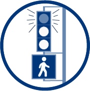
To complete the story about crosswalks, the locations where crossing is prohibited must also largely be removed. These locations are marked with the ‘no crossing’ sign at right (MUTCD R9-3a). Some of these locations probably never had crosswalks, some had them but were removed when the street was ‘upgraded’. A few of these locations cannot be made safe without complete reconstruction of the street. Freeway on-ramps and off-ramps, of which Sacramento has too many because it has too many freeways and too many freeways designed around commuting instead of interstate commerce, are particularly problematic. However, most locations indicate a clear intent by traffic engineers to prioritize the movement and speed of motor vehicles over all other considerations, including safety. This bias must be ended.

Here are the solutions:

  1. The city should be required to perform a complete traffic study on each and every location with a prohibited crossing. The traffic studies should be completed within two years.
  2. If the traffic study indicates that the prohibition is necessary for safety, then the prohibition can remain, but a new traffic study must be completed every five years. If the traffic study indicates that the prohibition was not made for safety reasons and is not needed for safety reasons, the prohibition must be removed and a marked crosswalk installed.
  3. City staff will analyze each prohibited location that remains to determine what redesign would make the prohibition unnecessary, and bring to the city council a proposal to expend funds to fix the location.
  4. At all prohibited locations, the city would be required to post informational signing with distances to the nearest safe crossing, in both directions.

Though I am picking on the City of Sacramento here, these prohibited crossings are found in every city in the region, and in abundance in unincorporated areas. All should receive the same treatment.

removal of crosswalks

In today’s SacBee, an article on the City of Sacramento’s removal of crosswalks (Why Sacramento erased 23 crosswalks, including one where a grandmother died after removal), which has contributed to at least one fatality, had the following information from Ryan Moore, the City Traffic Engineer.

“To send the message via crosswalk that this is a good place to cross the road is a false message,” Moore said of the Oregon Drive intersection. “Our standards dictated that we remove the crosswalk or build safety enhancements.” The city would have kept the crosswalk marking in place, he said, if it would have been able to install a traffic light there. But the money – in the $500,00 plus range wasn’t available. Instead, traffic engineers hope that by removing some crosswalks, pedestrians will instinctively choose to cross at a safer, nearby intersection, Moore said.

This is definitely the engineer perspective that says lives don’t matter as long as policy was being followed, and the windshield perspective that it is OK to make pedestrians walk out of their way so long as drivers are not inconvenienced.

Freeport-Oregon.png
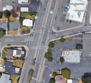
As you can see to the right, at the intersection of Freeport and Oregon, there are residences to the west and businesses to the right. There are signalized crosswalks about 700 feet to the north and about 700 feet to the south, but walking to either of these adds a one-quarter mile walk. Is this reasonable or not? It could be argued either way, but to discount it as Mr. Moore did demonstrates bias against pedestrians. The Google Map photo is from before the removal of the crosswalk.

The suggestion that nearby intersections are safer is also questionable. At the intersections of arterial roads, which Freeport and Fruitridge to the south are, drivers routinely fail to yield to pedestrians in the crosswalk on right turns. That is in fact why many walkers prefer to cross away from major intersections.

Common estimates of the expense of a HAWK signal (High-intensity Activated crossWalK) are $100,000, not $500,000. $500,000 is the cost of a fully signalized intersection. So Mr. Moore’s $500,000 number is a straw man meant to deflect criticism by saying the solution is more expensive than it really is.

There are solutions to this particular problem, and to the removal of crosswalks in general:

  1. The city should be required to perform a complete traffic study before removing any crosswalk. The city is always saying that they have to do traffic studies before anything can be done to change traffic flow, so I would presume that doing a traffic study in this situation would be a no-brainer.
  2. If the traffic study indicates that the crosswalk is unsafe, then the next step is to design a solution or options, with a funding estimate, and then go to city council with a request for the funding.
  3. The city council would have to hold a hearing, either as part of the regular city council meeting or as a separate meeting, to gather public input on the removal. If the city council then makes a decision not to expend the funds to create a safe crossing, the crosswalk can be removed.
  4. If a crosswalk is removed, the city would be required to post informational signing at that location with distances to the nearest safe crossing in both directions, so that pedestrians can make informed decisions. The signing would have to stay in place for at least two years.

Anything short of these actions makes the city engineers both morally and legally responsible for any fatalities or severe injuries that occur at the site of a removed crosswalk.


Complete Streets aren’t

The Complete Streets movement, now 13 years old and with a newly released criteria for evaluating policies, is considered by some to be a success. Not by me.

There are two gaping flaws in the complete streets concept, that after all this time have not been addressed:

  • Who is responsible for sidewalks?
  • How close should safe crossings be?

Sidewalks: On the first issue, responsibility for sidewalks, most cities and counties (not all) have code that makes sidewalk maintenance the responsibility of the adjacent landowner. This includes repair and snow removal. Most cities have some money set aside to repair sidewalks, but only a tiny fraction of what is needed for the huge backlog of deteriorated sidewalks. A very few cities also clear sidewalks after snow. Sidewalks are every bit as much of the transportation network as travel lanes and bike facilities, but most places wash their hands of this reality and this responsibility, pushing it off to others. It has been pointed out that few cities and counties have the funds to also take care of sidewalks, but that is exactly the point. If we allow cities and counties to prioritize cars over walking, they will continue to do so.

How does complete streets play into this? It doesn’t. Complete Streets set no expectation that cities and counties will maintain their sidewalks. In the new policy rating documents, the word sidewalk only shows up twice, neither in this context. Even a search of the Complete Streets website only mentions sidewalks in relation to case studies and model projects. Fortunately, a few places do much better than just have a policy, but the Complete Streets movement does nothing to encourage this.

ElCamino-eb
El Camino complete street, 0.3 miles to the next safe crossing

Crossings: the second great weakness of the complete streets movement and Complete Streets documents is the lack of attention to frequent safe crossings. The new criteria does not mention crosswalks or crossings. The illustrations of a complete street often show an intersection with high visibility crosswalks and sometimes curb extensions to increase visibility and shorten crossing distance. But other illustrations show long distances along a “complete” street, with the next safe crossing often not visible.

In the Sacramento region, every complete street project along arterials has added sidewalks and bike lanes, but none of them have added safe crossings. In fact, several of them have removed crossings. If a busy street is hard for walkers to cross, they won’t cross it. They will either drive, or just avoid the other side of the street. So that fancy complete streets project, with the wonderful looking wide sidewalks, does not serve the very people it is claimed to serve. People need to be able to cross any land all Streets in a safe crossing at an interval of no more than 1/8 mile. The grid in downtown Sacramento is 1/12 of a mile. Few places in the suburbs are less than 1/4 mile, and many are 1/2 mile. To me, this is unacceptable. I would think a complete streets policy would address this distance between safe crossings issue as being key to walkability. Again, the Complete Streets movement ignores this issue.

Curb extensions 16th & N

Curb extensions, also called bulb-outs, have been installed on all four corners at the intersection of 16th Street and N Street in midtown Sacramento. The extensions are the width of the parking lanes along both these streets. N Street has bikes lanes, which are not restricted by the extensions, while 16th Street does not have bike lanes, and won’t until the street is reconstructed into a more complete street at some unknown point in the future.

The primary beneficiaries of curb extensions are pedestrians, who have a shorter distance to cross, with every crossing being about six feet less distance for every parking lane, so in this case, 12 feet less. There is also much better visibility of cars by walkers, and of walkers by car drivers. Sometimes they also provide an opportunity for beautification, with rainwater swales and/or planting, as can be seen in the photo.

Every street with parking lanes should have curb extensions, so almost every intersection, but implementation will be slow because they are moderately expensive to construct (curbs sidewalks, detectable warning strips, better located ped buttons), and sometimes require drainage changes and occasionally even utility relocation. These particular extensions are certainly not the first in Sacramento, in fact there are extensions on the west corners of the intersection of 16th and O, just to the south, but are notable for being installed in a high pedestrian use area along two heavily trafficked streets.

Distracted walkers are not the problem

It has become popular recently to blame pedestrians for their own death. Some have always done this, from the beginning of the auto industry and its “jaywalking” campaign, but it is amazing how much law enforcement promotes this blame, how much the media buys into it, and how much transportation and safety agencies (Caltrans and OTS) market it. 

So let me share my experience. I walk, a lot, in addition to bicycling, a lot. Every day drivers refuse to yield my right of way when I am making legal street crossings. It makes little difference if I am waiting on the curb (where they are not required to yield, except by common courtesy), or waiting in the street, where they are absolutely required to yield to me. On multi-lane streets, when one driver stops for me, it is quite common for drivers in other lanes to not stop, though the law requires them to. I am never walking distracted, I make the personal choice to not look at my phone while crossing the street. But for anyone to suggest that it is the fault of someone walking distracted when a driver fails to yield right of way to a pedestrian, and kills them, is deeply, deeply offensive. This is similar to someone saying, well, I was just firing my gun and someone happened to walk in front of it. Cars are deadly weapons, and drivers are potential killers. It is time our society grew up and took responsibility for the harm that can be caused, and is caused, by our addiction to driving, and to the imputed freedom to run down someone who is just crossing the street. 

Walk Score update 2016-12

Walk Score offers an assessment of the walkability of any location. It is available in any browser at https://www.redfin.com/how-walk-score-works. The Redfin app shows walk score, bike score and transit score for each listing (scroll way down). Walk Score is based on the distance to the places people want to go, such as grocery stores, restaurants, coffee shops, bars, movie theaters, schools, parks, libraries, bookstores, fitness locations, drug stores, hardware stores, and clothing & music.

I’ve been curious about whether my Walk Score has changed with all the recent development in the area, since my earlier posts Walk Score (2012-03), Transit Score (2012-04), Bike Score (2012-05), and WalkScore update (2014-01). It has!

In March 2012, my Walk Score was 85: Very Walkable. In January 2014, my Walk Score was 82, Transit Score 62, and Bike Score 99. And today, my Walk Score is 91: Walker’s Paradise, Transit Score 63: Good Transit, and Bike Score 99: Biker’s Paradise. No big change in transit or bike, but a climb in walk score. And I am still tickled pink to be living where I do, in midtown Sacramento.

Quite a bit has changed on the Walk Score website over the years, and it is now much more focused on real estate. It has more in-depth information, but the algorithm is still proprietary. One of the beta features is a crime score, and my neighborhood ranks as a B.

walkscore_2016-12

people out walking!

Last evening I went for a walk, heading north to the Sac Northern trail, then the American River Parkway to Discovery Park, then across the Jibboom Bridge and into old town. I’d certainly seen bicyclists and a few walkers, but when I got to old town, there were hundreds of people walking around. I noticed they almost all had cell phones in hand, not that unusual, but still. I headed south along the river and saw yet more people. Then back along R Street where there were few people, until I got to the main part of R Street, and then into Fremont Park where there were yet more people. Remember, this was a Monday night largely after sunset, when I might see 10 people out walking in an evening, and I’d already seen at least 300. What was going on?

Well, you more culturally/technologically literate already know, but it took me some time to figure out. Pokemon GO! All of these people were playing the game on smart phones, looking for pokemons (is that the correct plural?).

I had heard a bit about the game, but didn’t realize it was taking the country by storm. Today, there were more prominent articles on all the media, even showing up on my main two news sources, Streetsblog and Strong Towns. I sat at Karma Brew with a Rasputin, and observed the goings-on in the park and along the streets.

So, what I saw, that I liked:

  1. People were out walking on a night when I would not usually see anyone. This means these people were getting physical activity when they would otherwise be in front of TV or computer.
  2. People were walking, looking at their smart phones, but they had their heads up, looking around, with the phone in their field of view but not their sole focus. Unlike most users whose heads are down and completely oblivious to what is around them. I’m not going to claim walking with a phone is safe, but I will say what I saw last night is significantly safer than what many people already do.
  3. People were talking to people in other groups, interacting with people they didn’t know. This is quite unusual. Even at bars and coffee shops, where people theoretically to to socialize, most people hang with their own group and do not interact much if at all with others.
  4. I heard people making comments like “I never knew that was there,” and “I always wondered what that was.” They were seeing things with new eyes. I am not sure how much of this discovery is designed into the app, but whatever is there results in people looking.
  5. People were hanging out in gathering places, old town, the promenade, R Street, Fremont Park. Again, whatever the design, this is where the pokemons were.
  6. People were not drinking. I have no problem with drinking, as long as you don’t drive, but I have to admit is was great to see so many people having such a good time without drinking.

As with any new technology, and any new social media, there will be hiccups. But on the whole I can see so many positives to this latest fad. I think I’m going to try it myself, though obviously not on my backpack trips. No pokemons out there!

back to the old ways?

https://transportationist.org/2016/03/14/follow-the-red-brick-road-streets-mn/

A post two days ago on Transportationist, “Follow the Red Brick Road,” reminds me of a topic that has been much on my mind – how do we effectively slow motor vehicle traffic? Speed limits are ineffective, stop signs are a complete waste, physical structures such as speed humps, speed tables, and chicanes work but only where they are present, narrower lanes work pretty well but get pushback from commercial drivers and agencies (fire engines, trash trucks, buses, etc.). What is needed is something that works continuously, and street surfaces may be the answer. The post recommends the use of an old material, brick, hence, back to the old ways.

The Traffic Calming entry on Wikipedia provides a summary of traffic calming measures, and one of them is surface materials or textures, but other solutions are more prominent. A common practice in many locations is to make crosswalks visually different, and sometimes texturally different from the rest of the roadway, on the theory that the difference raises driver awareness of the crosswalk. To some degree this may be true, but it probably has much less than the desired effect on traffic speed, and textural differences can present a challenge to disabled people and even to less adept walkers. The many different crosswalks patterns are an attempt to increase visual contrast with the roadway, but again, that is only partially successful.

So the idea is to reverse this pattern: make the roadway rough and the crosswalk smooth. We have a great example of this right here on Front Street in Old Town Sacramento, pictured below.

Crosswalk and cobblestones, Front Street, Old Town Sacramento

If you have not observed this street in action, I encourage you to do so. No one drives too fast on this section of street, in fact all motor vehicles are going a pedestrian-friendly speed. Yet the smoother crosswalk is usable by all and still has a high contrast with the road. Compare that to nearby Second Street, where a normal pavement surface encourages some irresponsible drivers to go much faster than is safe given the tourist pedestrians that frequent the area.

Of course the cobblestones here are an historical artifact, and such a rough surface would only be appropriate in high pedestrian traffic areas. But brick would be a great middle ground between cobblestones and asphalt.

While I have long supported this reversal of textures, I doubted that it would be practical to implement. But the video at the bottom of the “red brick” post provides a solution, a machine designed to lay down brick in an efficient manner. The process is slow, but I think that is because they are changing brick patterns to demonstrate different possibilities. Where the pattern remains the same, it would go much faster, and the feed of bricks could be automated.

If you have ridden your bike on these cobblestones, you know that the surface is very rough. When cars are not parked along Front Street, the cobblestones can be bypassed on the asphalt parking area on the west, but when it is full, yow! Obviously brick is much less rough than cobblestone, but nevertheless bike access is an issue to be considered. Maybe brick would be no problem (if it is maintained, but then bike lanes often have unmaintained asphalt or concrete anyway), or maybe the bike lane would need a different surface. A visual or textural difference might cause drivers to notice and respect the bike lane more than they do now, with just a white stripe and occasional green paint to distinguish it. This needs more thought and study.

I would guess that brick streets would be more expensive than asphalt, which is sort of the lowest common denominator of pavement, but might be comparable to concrete, and cost is always an issue in constructing and maintaining streets. But I’d like to see some pilot street projects, starting with locations where it is really important to increase safety and promote walkability, right here in Sacramento. If the pilot goes well, then let’s make it the standard street surface for the grid, implemented anytime repaving is indicated.