The City of Sacramento Active Transportation Commission (SacATC) will meet today, May 16, 2024, 5:30PM in city council chambers, 915 I Street.
The main agenda items are:
Folsom Boulevard Safety Improvements Project
Envision Broadway in Oak Park Project
Broadway Vision Zero Project
Draft Sacramento Urban Forest Plan Public Release
These are all discussion and feedback items, not for decisions.
The first item looks like a good project. For each segment, option 2, with buffered bike lanes, is the best option. Wider bike lanes have an advantage in that they accommodate more kinds of bicycles, but most bicyclists appreciate the visual if not actual protection of buffers and vertical delineators.
This project is the result of community pressure on the city to respond to the fatality that occurred at Phoebe Hearst Elementary, and the generally hazardous and hostile environment for walkers and bicyclists.
Folsom Blvd cross-section, 53rd St to 63rd St, option two buffered bike lanes
For all three complete street projects, I feel that center turn lanes are given way too much prominence, while in many segments they are unneeded because there are few driveways and few turning movements too/from cross streets. As always, the problem with with planning streets from the inside out, whereby motor vehicle space is set aside before anything else. Planning from outside in ensures that sidewalks and bicycle facilities are taken care of and of high quality, and then driving and parking needs are taken care of secondarily.
You can comment via eComment at the city’s meeting page, http://sacramento.granicus.com/ViewPublisher.php?view_id=21, before the meeting starts, or in person. Of course in-person is more powerful, but eComments are valuable and the only method many people can use.
City staff announced that due to hiring a consultant and the project timeline, the updated Vision Zero Action Plan would not be available until sometime in 2025, not this year.
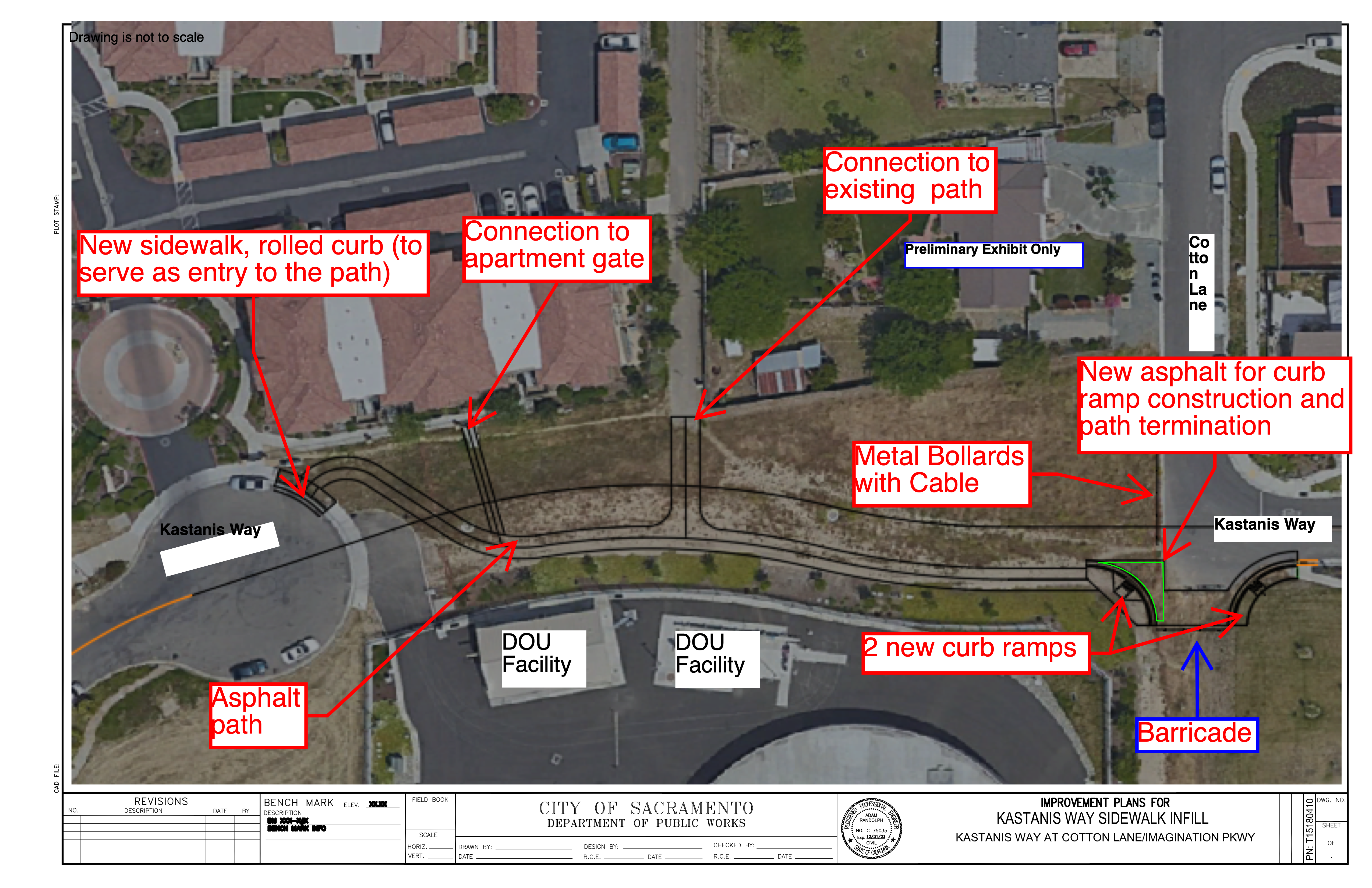
Agenda 4: Kastanis Shared Use Path. This is a wonderful project, connecting two ends of a dead-end street for walkers and bicyclists. It received my support and the full commission. Commissioners asked about lighting and trees, but as a sidewalk infill project from a very limited program, those could not be included.
Agenda 5: Grand Avenue Sidewalk Infill. Another wonderful project, adding sidewalks on Grand Aveue adjacent to the Sacramento Northern Trail for better neighborhood access included ADA ramps on all corners. A SacRT bus stop location will also be improved. Again, my support and the full commission. Commissioner Harris, who represents District 2, spoke about the lack of sidewalks throughout much of the district, and the benefit of any infill projects.
I spoke on items ‘not on the agenda’, asking that the slide presentations be made available before the commission meeting whenever possible. There is often information in the presentations not available in the staff report, which can make a project look better, or worse. I also suggested that the commission ask for a presentation on how the city views its responsibility for bus stops, since this came up many times in discussion of the Grand Avenue project.
I hope that more people will attend the SacATC meetings and comment on projects (on online via eComment). This is the only real chance for public input on projects, other than going to your council member. Most Public Works projects are a black box without public input, so when there is the chance, it is time to speak up for safer and innovative solutions.
And now on to the more complex project, which took up the majority of the meeting time.
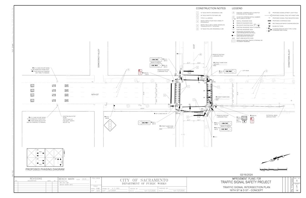
Agenda 3: Traffic Signal Safety Program. There was a staff presentation with a slide deck that was not available to the public (this is an ongoing problem, see below). Though the diagrams in the presentation were much more detailed than the ones in the staff report, they still left out a lot about the context of the intersection. What is it close to? Are there already a lot of walkers? How far is it to the next safe crossing? Is a traffic signal the best solution? It was clear from answers to commissioner questions that a lot of information was missing. Apparently this project is the result of a SACOG grant made to the city in 2017. Presumably there was a resulting document on the project, but that was not made available. The staff person said site selection was based on traffic warrants, but then exhibited a lack of knowledge about warrants. The question came up about whether the city could install a signal of any type that didn’t meet designs in the CA-MUTCD (California version of the federal Manual for Uniform Traffic Control Devices). The initial answer was no, but this was revised to yes, however a grant would be unlikely to be obtained that included non-MUTCD designs.
Overall, the entire traffic signal project is disappointing. The traffic engineering section of Public Works seems to have a very simple view of the world, to wit, a street with an unsafe design > a traffic signal. Changing the street design? Nah. Calming traffic to make the crossing safer? Nah. Shortening the crossing distance? Nah.
Traffic signals are expensive! Though no budget detail was provided, it is reasonable to assume from the overall $7.9M budget, which includes four full traffic signals, three pedestrian signals, and two RRFB (rectangular rapid flashing beacon) that full traffic signals cost about $1M each. That kind of money could fund a lot of traffic calming with lane reductions and curb extensions. Please take a look at my agenda post, and a comment from Sean Rogers that provides a much lower cost alternative for the Monroe Street and Latham Drive intersection.
Traffic signals do not necessarily create safer streets. Certainly, they don’t promote safety in between signals, as drivers accelerate to previous, often egregious, speeds as soon as the light turns green. With rampant red-light running, stop signs are probably much safer than signals. Though drivers also run stop signs, they do so at much slower speeds, whereas drivers running red lights often accelerate into the red light, ensuring the death of anyone in their path. If there are no gaps in traffic on a roadway, then it is necessary to create gaps with some sort of control, but a traffic signal is often the dumbest and most expensive way of doing that.
California has two years from the adoption of the federal MUTCD, which was December 2023, to either submit its own version, or the federal version will be the version for California.
The federal MUTCD (2023) has some interesting text (Section 4B.03 Alternatives to Traffic Control Signals): “Since road user delay and the frequency of some types of crashes are sometimes higher under traffic signal control than under STOP sign control, consideration should be given to providing alternatives to traffic control signals even if one or more of the signal warrants (see Chapter 4C) has been satisfied”, followed by 14 alternatives to traffic signals.
Section 4C.01 Studies and Factors for Justifying Traffic Control Signals provides a list of nine possible warrants to justify a traffic signal:
Warrant 1, Eight-Hour Vehicular Volume Warrant 2, Four-Hour Vehicular Volume Warrant 3, Peak Hour Warrant 4, Pedestrian Volume Warrant 5, School Crossing Warrant 6, Coordinated Signal System Warrant 7, Crash Experience Warrant 8, Roadway Network Warrant 9, Intersection Near a Grade Crossing
It is unknown which of, or any of, these were used to justify the signal locations. There are very detailed (and hard to understand) explanations of each of these warrant types.
My comments on the project, which I did not quite finish (two minutes is a short time), included:
Signals are not necessarily a safety feature for people walking, unless there are no gaps in traffic, the more important issue is to calm traffic on the approaching streets
We already have a lot of unneeded signals, where the traffic volume and context of the intersection does not justify a full traffic signal, perhaps 60 of them just in the central city
16th & D: traffic on 16th St needs to be calmed, signal will probably not shorten wait time for crossing
Rio Linda at Roanoke: lacks a connection to Sacramento Northern Trail, which would make it a great deal more useful, posted speed 40 mph is too high for an RRFB
Monroe and Latham: traffic calming through lane reduction and curb extensions would be as effective as a signal (Sean Rogers comment)
At about $1M for a full traffic signal, there are much less expensive alternatives, and much better ways of spending limited funds
The monthly meeting of the Sacramento Active Transportation Commission (SacATC) will be this Thursday, April 18, 2024, starting at 5:30 PM in the city council chambers. You can comment on these items, or on topics not on the agenda, ahead of time via eComment, or in person at the meeting. I encourage people to attend these commission meetings. There are usually very few members of the public in attendance, which means that your voice is important. Though eComments are valuable, in-person comments carry a lot more weight. The city’s planning staff is usually progressive and innovative, but Public Works in general is not, so it is important the citizens show up to push for progressive and innovative projects and policies. With some new appointments to the commission, and support of the public, the commission itself has been much more progressive than in past years.
Kastanis Way Shared Use Path looks like a great project, connecting two dead-end streets for walkers and bicyclists, but not motor vehicles. These are the kinds of projects that should be implemented everywhere the opportunity exists.
Kastanis Way shared use path
Grand Avenue Sidewalk Infill also looks good, providing improvements to the crossing Grand Avenue by the Sacramento Northern multi-use path.
Grand Avenue Sidewalk Infill project
The Traffic Signal Safety project is questionable. There are nine locations:
16th Street at D Street (Traffic Signal)
Franklin Boulevard at 36th Avenue (Traffic Signal)
Freeport Boulevard at Kitchner Road (Traffic Signal)
Fruitridge Road at 60th Street (Pedestrian Signal)
Rio Linda Boulevard at Harris Avenue (Rectangular Rapid Flashing Beacon)
Stockton Boulevard at 11th Avenue (Pedestrian Signal)
24th Street at 25th Street (Pedestrian Signal)
Munroe Street at Latham Drive (Traffic Signal)
Rio Linda Boulevard at Roanoke Avenue (Rectangular Rapid Flashing Beacon)
I haven’t had a chance to look at each of these proposals, though I will note that the city traffic engineers love to install traffic signals. At $100K to $500K per intersection, these are major investments. Many of the new signals the city has installed, for example on 5th Street and S Street, are unneeded, and waste of money. They have also converted a number of pedestrian signals from auto-recall (the pedestrian signal comes on at every signal cycle) to beg buttons (the person walking or rolling must activate the sensor, or the pedestrians signal will never come on). The city has a number of unnecessary signals, 60 in the central city alone. Maybe a one-for-one program is called for, install a new signal, take out an existing signal.
I don’t trust city traffic engineers. They label projects as safety projects for walkers and bicyclist, when they are really motor vehicle infrastructure projects. So-called pedestrian and bicyclist safety projects are often motor vehicle enhancements in disguise.
I cross 16th Street at D Street several times a week on bicycle, and occasionally walking, most often to access the American River bike trail via Sacramento Northern path over the river. Yes, I have to wait for a gap in traffic on 16th Street, which sometimes takes a while. But rarely longer than I would have to wait for a traffic signal, given that the arterial street (16th Street) always has a long green and the cross street (D Street) has a short green. I think that funds would be better spent slowing motor vehicle traffic on 16th Street, or adding bike facilities to 16th Street, or reducing the travel lanes on 16th Street, which is a four-lane traffic sewer. Traffic signals do not calm traffic. They irritate drivers, and cause them to quickly accelerate out of the signal to make up for time lost at the signal. They may allow for safer pedestrian crossing, or at least would if red light running were not an epidemic in Sacramento. The fact is, many drivers do not stop for red lights, and certainly don’t stop for people walking in crosswalks. Measures other than traffic signals are necessary to solve the issue.
traffic signal at 16th St & D St
The proposal for an RRFB (Rectangular Rapid Flashing Beacon) for Rio Linda Blvd at Roanoke Avenue is inappropriate. The posted speed limit in this section of Rio Linda Blvd is 40 mph, meaning that actual speeds are more like 50 mph. This is too fast for an RRFB to have any effect on drivers. Even at slower speeds drivers often ignore RRFBs. If there is to be a safe crossing at Roanoke, there must be a HAWK signal, or a full traffic signal. Again, funds would be better expended slowing traffic on Rio Linda. At this time, there is no connection between Roanoke Avenue and the Sacramento Northern Bike Trail, so it isn’t clear why this location has been picked for a signal.
RRFB for Rio Linda Blvd & Roanoke Ave
I will leave it to others to examine the other seven locations. Are signals needed? Are they the right kind of signal for the context, particularly the speed and volume of motor vehicle traffic? Are there projects that would improve safety for walkers and bicyclists more than expensive traffic signals? Are these the best locations, the ones that best serve routes of travel for walkers and bicyclists? I have doubts that these questions were considered.
Note: Readers Sean Rogers has suggested a better, and less expensive, solution for Monroe and Latham, in comments. The solution may be calming traffic, not just installing a signal.
At the city council meeting in which the SacATC Annual Report was discussed, Councilmember Venezuela directed staff to come back with a plan for a quick-build program, which will be developed over time
Ali Doeer-Westbrook relayed that Councilmember Vang requested that if the city is not going to act on a recommendation, they respond with reasons why; it is not clear how this will play out
Agenda 3 Streetcar (SacRT Anthony Adams presentation): went over the new proposal and alignment, and said this is phase 1, West Sac plans to extend way south; $160M project, with $130 secured so far, includes federal SmallStarts, construction 2027 if remainder of funding obtained; just submitted RAISE grant application and will submit state TIRCP grant; short segment on N will be shared sidewalk with bicycles, otherwise not, MAC asked for physical barrier on shared section, N Street will remain one way (per city direction, not converted to two-way), several of the slides presented were not in the agenda document but had additional detail
I commented on the 3rd St bike lane, it has only a narrow buffer, which is unacceptable adjacent to three high-speed traffic lanes, shared should be removed from 11-foot lanes and given to bike facilities; Matt Anderson talked about Class 2 bike lanes on the bridge (may be too narrow as well), which would be unsafe, and alternate routes; Deb Banks said the bike lanes could be raised to provide protection from motor vehicles
Agenda 4 Parks Plan: no public comment, David asked about parks designated as high need, which was not available tonight
Agenda 5 T-Street gap closure: this is a preliminary plan, but intended to fix issues with T Street rather than waiting for the Stockton Blvd reconstruction which is a ways off; presentation followed the agenda item document
My comments: good project, reduction 4 to 2 lanes under freeway is great, parking shown on 34th Street to 35th Street not needed; and removing it on the north side would allow a completely separated and protected bikeway for that block; most traffic turns right on Stockton, so right lane could be right turn only rather than pushing the merge onto T Street east of Stockton Blvd
Several people spoke in favor of a bike box for T Street at Stockton Blvd, but I’m not sure what exactly that means.
Agenda 6 ATP7, Jennifer Donlon Wyant presenting: She presented briefly on each of the projects; she said if the Freeport grant was approved, it would come back to the commission for design comment, which was a surprise as the agenda item did not indicate that; this guarantee seemed to make the commision comfortable enough that Freeport was included in the unanimous motion to recommend to council; when asked about priority of the three projects, Jennifer said they were not prioritized, but Northgate Blvd was highest on the Transportation Priorities Plan list
For items not on the agenda, I mentioned several items:
Update: Diagrams were added for agenda item 3 streetcar-related bikeway on 3rd Street and agenda item 5 T Street bikeway improvements with unneeded parking. Update 2: Information added about Envision Broadway in Oak Park, one of the project applications desired for ATP7.
The monthly meeting of the Sacramento Active Transportation Commission (SacATC) will be this Thursday, March 21, 2024, starting at 5:30 PM in the city council chambers. You can comment on these items, or on topics not on the agenda, ahead of time via eComment, or in person at the meeting. I encourage people to attend these commission meetings. There are usually very few members of the public in attendance, which means that your voice is important. Though eComments are valuable, in-person comments carry a lot more weight. The city’s planning staff is usually progressive and innovative, but Public Works in general is not, so it is important the citizens show up to push for progressive and innovative projects and policies. With some new appointments to the commission, and support of the public, the commission itself has been much more progressive than in past years.
Downtown Riverfront Streetcar Project – Active Transportation Elements
Draft Parks Plan 2040 Public Release
T Street Bikeway Gap Closure Rehabilitation Project (R15200030)
Active Transportation Program Cycle 7 Grant Applications
Item 6 is mislabeled as a discussion item since it says: “Pass a Motion to recommend to City Council the approval of applications to the Active Transportation Program Cycle 7 grant applications for the following projects: a) Envision Broadway in Oak Park; b) Freeport Boulevard Safety and Mobility Project; and c) Northgate Boulevard Safety and Mobility Project.”
The Downtown Riverfront Streetcar Project, for a streetcar or light rail extension from Sacramento Valley Station to Sutter Health Park in West Sacramento, with an alignment over Tower Bridge, south on 3rd Street, east on N Street to 7th Street (southbound) and 8th Street (northbound), and along existing tracks to Sacramento Valley Station. Class IV bikeway is proposed on 3rd Street southbound, off or left side, and N Street eastbound, off or left side. There is no detail about what kind of Class IV bikeway, which can be: ““A bikeway for the exclusive use of bicycles and includes a separation required between the separated bikeway and the through vehicular traffic. The separation may include, but is not limited to, grade separation, flexible posts, inflexible posts, inflexible barriers, or on-street parking.” Since the bikeway is not parking protected, a high level of protection and separation is appropriate. Both the map and StreetMix diagram are too fuzzy to determine bikeway and buffer width, but it appears the bikeway buffer is narrow and without vertical delineators. The three general purpose lanes are 11 feet, unnecessarily wide and unsafe, so there is additional space that could be allocated to the bikeway or buffer.
StreetMix diagram of 3rd St, excerpted from agenda item
The Parks Plan 2040 (to align with the General Plan 2040) includes many mentions of trails, particularly in the context of Parkways: “Parkways: There are 14 parkways across the city. All parkways contain multi-use trails; some have artwork, gardens, river/beach access, and picnic areas. A select few offer sports recreation facilities such as basketball, soccer, and volleyball.” Key Direction 6, Foster Nature and Trail Connections includes “Collaborate to Improve Trail Connections: As noted in Appendix D, YPCE will continue to coordinate and collaborate with Public Works, other City departments, Sacramento County, and other agency partners to improve trail connections to parks, parkway use, and recreation via trails. While YPCE is not the primary provider of the City’s shared use paths, the Department brings an important perspective to conversations regarding priorities for shared use paths that support recreation and park access in addition to active transportation. Going forward, YPCE will proceed with the development of planned future parkways, especially where these provide access to rivers, connect missing trail links, and provide access to new parks and neighborhoods.” The Community Voices section (04) indicates strong community support for trails.
The T Street bikeway improvement project is needed, from 34th Street to Stockton Blvd. I bicycle this section regularly, on my way to Trader Joe’s and other destinations. The bike lane comes and goes, and drivers often refuse to yield to bicycles taking the lane, trying to force them to the side, and then right-hooking them at Stockton Blvd. The included diagrams seem to indicate there will be parking along the north side of T Street between 35th Street and 34th Street, which is completely unnecessary since the north side is entirely a Caltrans corporation yard with no need for parking. About two-thirds of the south side is also Caltrans property under the freeway, again with no need for parking. T Street is reduced from four travel lanes to two travel lanes from 34th Street to 36th Street, which is a great traffic calming improvement over the overly wide street that exists (or did, before the Hwy 50 construction narrowed it). The right hand lane approaching Stockton Blvd should be right turn only, so that T Street drops to one lane east of Stockton, without the need for a merge which endangers bicyclists. My observation is that at least half the eastbound traffic on T Street turns right onto Stockton, rather than continuing straight onto T Street or turning left onto Stockton. There are also bike lane improvements on the section of 34th Street approaching T Street.
T St between 34th and 35th streets, showing unneeded parking
The city is proposing to submit three applications to the Active Transportation Program Cycle 7: a) Envision Broadway in Oak Park; b) Freeport Boulevard Safety and Mobility Project; and c) Northgate Boulevard Safety and Mobility Project.
I have not looked in any detail at the Envision Broadway in Oak Park project, which lies to the east of the current Broadway Complete Streets project. If the same street cross-section and neglect of sidewalks is continued east, it will be a bad project, but perhaps this is an opportunity to correct the design mistakes built into Broadway Complete Streets.
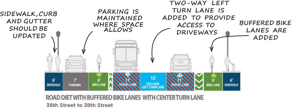
Added information on Envision Broadway. Overall, the plan looks good. Of concern is the section from 36th Street to 38th Street, where the right-of-way is narrower, and existing sidewalks are mostly 5 feet, which is unacceptably narrow for this corridor. The plan says “South of 36th St the rolled curb and gutter and attached sidewalks should be replaced with vertical curbs and wider sidewalks where feasible”. The phrase ‘where feasible’ is concerning. Would we say that general purpose lanes would be installed ‘where feasible’? Of course not. Sidewalks must be a minimum of 6 feet throughout this section, even if other modes are reduced. The sidewalks will not have sidewalk buffers for planting trees, so this section will be unshaded, except for a very short area between 36th Street and 4th Street, where there is a buffer, and a few trees on private property.
The project should still be recommended by SacATC, but with recognition that the plan falls short in facilities for walkers.
The initial Freeport Blvd Transportation Plan was deeply flawed, but perhaps this preliminary engineering and environmental clearance phase can correct some of those flaws. If not, then Freeport will stand as an example of how the city still prioritizes motor vehicles over all other users, and over trees. If the the city does not make a commitment to significantly improving the plan during this phase, then I believe the community should oppose this grant application, at SacATC, and California Transportation Commission, and at SACOG.
The 2023 Annual Report from the Sacramento Active Transportation Commission is agenda 5 for the Sacramento City Council on March 12, 2024, starting 5:00PM. Unfortunately, the item has been placed on the consent agenda. Every transportation advocate in Sacramento is disappointed that it is on consent, because we feel that the report deserves discussion by council. The report is critical to the future of active transportation in the city, and all the livability and safety benefits of active transportation, so the consent agenda minimizes its importance.
The public may comment on items on the consent agenda, both in eComment beforehand, and at the meeting. In-person comments are always weighted more than eComments, but if eComment is all you can do, please do! However, unless a council member pulls the item from consent, it will not be discussed by the council. If it were pulled from consent, I assume that City of Sacramento Transportation Planning Manager Jennifer Donlon Wyant and 2024 SacATC chair Arlete Hodel might present the report to the council.
To comment in person, you must submit a request to speak before the agenda item comes up, which will be very close to the beginning of the meeting at 5:00PM. Once the consent agenda comes up, it is not possible to submit a request. Speaker cards are on the back counter, to your left when you walk in to chambers, and the basket for cards is at the left front of chambers. Though you can of course comment on anything during the ‘items not on the agenda’ at the end of the meeting, it is much better if you can comment directly on the agenda item in question.
Even if you cannot comment, the Annual Report is well worth a read. The Sacramento Active Transportation Commission has shifted to a much more progressive and activist stance over the last two years, and the ten recommendations in the report (starting on page 8) should be implemented by the city. These are listed below, but read the document for supporting details.
Increase Funding for Active Transportation Infrastructure Projects
Develop a Citywide Safe Routes to School Program
Expand Speed Management Programs
Pilot an Electric Bike Library
Promote E-Bike Incentives
Create a Sacramento Quick-Build Bikeways Program
Increase Bike Parking
Re-establish Slow & Active Streets
Finalize the Construction Detour Policy
Develop an ATC Dashboard
If you are going to comment, I recommend that you pick one item of most importance to you, and comment on that. Personal perspectives are best, why the lack of these programs has harmed you, or why the implementation of these programs will benefit you.
The monthly meeting of the Sacramento Active Transportation Commission (SacATC) will be this Thursday, February 15, 2024, starting at 5:30 PM in the city council chambers. The agenda includes five items. You can comment on these items, or on topics not on the agenda, ahead of time via eComment, or in person at the meeting. I encourage people to attend these commission meetings. There are usually very few members of the public in attendance, which means that your voice is important. Though eComments are valuable, in-person comments carry a lot more weight. The city’s planning staff is usually progressive and innovative, but Public Works in general is not, so it is important the citizens show up to push for progressive and innovative projects and policies. With some new appointments to the commission, and support of the public, the commission itself has been much more progressive than in past years.
Agenda item 3 is a presentation on the Truxel Bridge Concept and Feasibility Study. The Truxel crossing of the American River was originally proposed and approved by SacRT and the county as a transit-walking-bicycling bridge, carrying light rail from downtown to Natomas. The city is now proposing a motor vehicle-transit-walking-bicycling bridge. They are claiming that the bridge would reduce vehicle miles traveled (VMT) through the provision of alternative modes, and a shorter trip between downtown and Natomas, but has not presented data to justify this claim. New roadway capacity induces more motor vehicle trips, a well-established fact, so to claim otherwise requires proof. Walking and bicycling would be unlikely to be the major component of bridge users. Transit availability could reduce motor vehicle trips, but the Green Line to the Airport is probably decades away, and anything short of service to North Natomas would be unlikely to replace many car trips.
The city intends to go full speed ahead (pun intended) with the bridge, based on a 2013 city council approval, seeking public input only on the southern approach to the bridge and the bridge cross-section. Since 2013, the city has declared a climate emergency, the Mayors Commission on Climate Change goal is to achieve Carbon Zero by reducing VMT, the soon-to-be-adopted General Plan 2040 and Climate Action and Adaptation Plan aim for reducing VMT rather than increasing it, and SB 745 required VMT impacts as the primary criteria for judging projects. Most importantly, public awareness of the risk of motor vehicle induced climate change has emerged and strengthened.
Please see previous posts in category ‘Work Zones‘.
The City of Sacramento is hosting a webinar on the draft Work Zone and Event Detour Policy Update, today, January 24, 6:00PM. You can register for the Zoom webinar here(registration is not available on the Work Zone webpage).
I have neglected to post on the SacATC (Sacramento Active Transportation Commission) review of the Work Zone and Event Detour Policy. Commission members had several good ideas and questions, which are worth capturing. You can view the meeting video at https://sacramento.granicus.com/player/clip/5786. Note that the sound quality is very poor, with many dropouts. Since I was at the meeting, I have filled in some details on the comments.
Comments/questions from commissioners:
Houpt: advocates should have a chance for input, is that part of the noticing process?
Hodel: Old Sac boardwalk (promenade) has been completely closed to bicycles for events; should be consequences for blocking access; supports rerouting motor vehicles is necessary; hefty fines for non-compliance
Moore: Class 2 bike lanes are already dangerous so reproducing them as diversions or detours is still dangerous; provide physical safety; rely on automated enforcement, not police presence
Gonzalez: is there a definition for ‘short pinch point’?; concerned about monitoring, suggested QRcode at location for immediate report of dangerous situation
Gibson: asked for details on enforcement at events; should be separate for short term events versus long-term construction project
Banks: how will the city get word out about events and construction that impact access; suggested more photos, particularly for events
Erasmus: assistance for event sponsors who may not have the resources to post events
Doerr Westbrook: could longer term projects be reflected in Google maps?; there may be some more recent Caltrans info on bicyclist detours; is there a database for locations and TCP documents? Can the document refer to federal guidelines on bicycle facilities for ADT levels, rather than city? (Reply was that the Streets for People Active Transportation Plan will update that guidance, and replace old Bicycle Master Plan at that time)
The Community Development AgencyCounter map (https://sacramento.agencycounter.com/) could be one location to store TCP locations. It does not appear to have document links, but would at least allow people to find locations and request documents.
I have written twice before about the SacATC recommendations: support SacATC status on walking/biking (now!) and SacATC meeting Jan 19 with report, Northgate, Freeport. I recommend you read the full set of recommendations. Do they go far enough? No. Do they miss some important issues? Yes. But these recommendations are beyond anything that the city has considered before, and deserve the support of everyone in the city (and county and region).
Several representative from Land Park talked about how much they loved the slow streets in the park, and how disappointed they were when the city nixed them. They want them back! So do a number of other speakers. Grace Bartley talked about how she was hit by a driver while riding her bike to McClatchy High on Freeport, probably the most impactful speaker of the evening. Several speakers mentioned the imperative to control motor vehicle speeds, by whatever means necessary. (The ultimate solution to this issue is not any action of the city, but speed-limited motor vehicles.)
Eric Guerra mentioned again, as he has other times, that many parents seem to care about only their own children, once their children are safely dropped off at school, they speed away, endangering other people’s children. And some not ever their own children, encouraging their kids to run across the street at drop-off and pick-up. There was general agreement that there needs to be more money in next year’s budget for active transportation, though no one said what would be cut to accomplish that. SacATC had wanted their recommendations to go to the council for consideration in adopting this year’s budget, but a roadblock (intentional?) was thrown up by requiring that the report go first to the Personnel and Public Employees Committee, which meant that it did not come to the council until August. Katie Valenzuela suggested that Public Works come up with guidelines for citizen-initiated ‘tactical urbanism’ projects so that quick-builds can happen now, when the city does not have the funds or materials or personnel to complete in a timely manner. Jennifer Donlon Wyant was open to the idea, but I’m sure it would get nixed in Public Works. Darrell Steinberg talked about his proposal for a housing and transportation measure in 2024, that would provide some of the additional funding needed. This will be the topic of my next post.
I spoke along with the other 19 people, and my comments are below:
I strongly support all of the recommendations included in the 2022 report from the ATC to the city council. In particularly, I would like to address two of those, 3. Develop a Citywide Safe Routes to School Program, and 4. Finalize the Construction Detour Policy.
I was the Safe Routes to School Coordinator for San Juan Unified for 10 years. Having that position funded through federal and ATC grants, and district funding, allowed the completion of many infrastructure project though collaboration with the City of Citrus Heights and Sacramento County. Most of these would not have occurred without the position. We also offered an extensive program of walking and bicycling education to students, and to the community. Civil Thread/WALKSacramento was a key partner in these efforts. I recommend that Sac City schools and the city create and fund a Safe Routes position to head an ongoing program in the support of students and their families.
It is long past time for a policy to accommodate walkers and bicyclists during construction projects. Nearly every construction project that has occurred in the central city has violated ADA guidelines, which require accommodation. City staff is on record as saying that walkers and bicyclists would be accommodated when it does not remove capacity from motor vehicles. So every project presents dangers to walkers and bicyclists. The are poorly signed and do not provide detectable barriers. I spend a lot of time reporting these violations, and over time many though not all of them are corrected. However, it should not be the responsibility of citizens to hold the city to ADA requirements. A progressive city would develop traffic plans that accommodate all travel modes, and would then inspect and enforce those plans.
I encourage you to support the Sacramento Active Transportation Commission’s (SacATC) sending the Status of Walking/Biking committee report to city council. The report is on the agenda for SacATC on this Thursday, 6:00PM to about 8:00PM.
The report is the first attempt since the early days of the SacATC to actually address transportation policy. The SacATC has unfortunately become a rubber stamp for city grant applications, and has not delved into policy since the early days when an update of the city’s Bicycle Master Plan being completed, and the ATC was able to make some improvements to that. The commission was formed to advise council on policy (it is NOT advisory to staff, but to the council), but has not done so. Now is the time, and this status report should be supported because it finally starts to address policy.
The status report includes nine recommendations:
Increase Funding for Active Transportation
Expand Speed Management Program
Develop a Citywide Safe Routes to School Program
Finalize the Construction Detour Policy
Develop an ATC Dashboard
Create a Sacramento Quick-Build Bikeways Program
Pilot an Electric Bike Library & Promote E-Bike Incentives
Increase Bike Parking
Re-establish Slow & Active Streets
I’m sure you can think of many other recommendations that might be made, but this is a great start. If the council pays attention to these recommendations, and takes action to create and fund programs, the status of walking and bicycling will have improved by next year, and more items can be added.
Call in by telephone, 888-788-0099, and ‘raise your hand’ by dialing *9 (star-nine) when the agenda item comes up.
Consult the agenda for more detail on making public comment. It used to be possible to submit email to the city clerk, but this option is no longer mentioned.