improving 15th & Q

I live in downtown Sacramento, and walk through the 15th Street & Q Street intersection almost every day, sometimes multiple times a day. On the southeast corner is my favorite coffee shop, Naked Lounge (I drink tea, not coffee, but they have a good selection). I often sit outside watching people and traffic, so I am very familiar with this intersection. Fremont Park is on the northeast corner, and again, I walk through the park pretty much every day. Let me say up front that this is not a high injury intersection that must be fixed soon. There are so many more dangerous intersections in the city to address first, and so many locations where poor engineering and disinvestment and discrimination has left walkers and bicyclists at great risk. But I can start here because I think about it so much.

A photo of the intersection. The trees on the northwest corner obscure the corner and part of what I’m going to talk about. The sidewalk, curb, ramps, and parking on the southwest corner are all new, as this was reconstructed along with the 1430Q apartments and ground floor retail. The other corners have not changed recently. 15th Street is a three-lane one-way street (it should be reduced to two lanes and bike facilities added), and Q Street is a two-lane one-way street with bike lane on the left side. The northwest, northeast, and southeast corners have small radii, meaning tight corners. The southwest has a high radii corner, meaning loose corners. This is new.

15th Street & Q Street, Sacramento

The wide radius corner on the southwest must have been someone’s idea of necessary for trucks turning from Q Street eastbound onto 15th Street southbound. But notice the northeast corner, which is just as likely to have such turning movements, has a small radius corner, and I’ve never seen a problem with trucks turning there.

Three of the corners do not have curb extensions. On the southwest corner, there is a curb and sidewalk extension along 15th Street, running about half way to the alley. Curb extensions (also called bulbouts) extend the curb and sidewalk out over the parking lane, slow drivers due to perceived friction, and shorten crossing distances for people walking. They are a known and frequently implemented safety solution. You can see curb extensions at a number of locations in the central city, though strangely, only about half the reconstructions install them. The extensions also create more sidewalk waiting or queueing space for walkers, important on busy pedestrians intersections such as this.

The southwest corner gets a lot of deliveries, both for the businesses below and the apartments above. The southeast corner has fewer deliveries. Delivery use should be considered in any change that is made at and near this intersection. On 15th Street, there are green 15 minute parking spots, one on the east, primarily for the coffee shop, and two on the west. On Q Street, there is one green spot on the south, along with about two white curb spots. There are no delivery (white curb) zones on the southeast corner. Green limited time parking and white commercial loading zone markings are relatively rare in Sacramento.

While having tea this afternoon, I saw a driver on 15th Street run a red light and almost collide with a Sacramento Fire Department truck turning from Q Street onto 15th Street. Lights, siren, loud horn, makes no difference to some drivers. I see a lot of close calls at this intersection, but have never witnessed a collision. A person sitting nearby mentioned that she works at another coffee shop on J Street, and sees collisons fairly regularly. Those who claim the solution to street safety is solely redesigning streets to slow traffic ignore that there are also drivers who won’t drive safely no matter what. There is nothing about street design that can prevent someone from running a red light, except of course not having a traffic signal there at all (too many traffic signals?).

To make this intersection safer for everyone (walkers, bicyclists, motorists), these changes could be implemented:

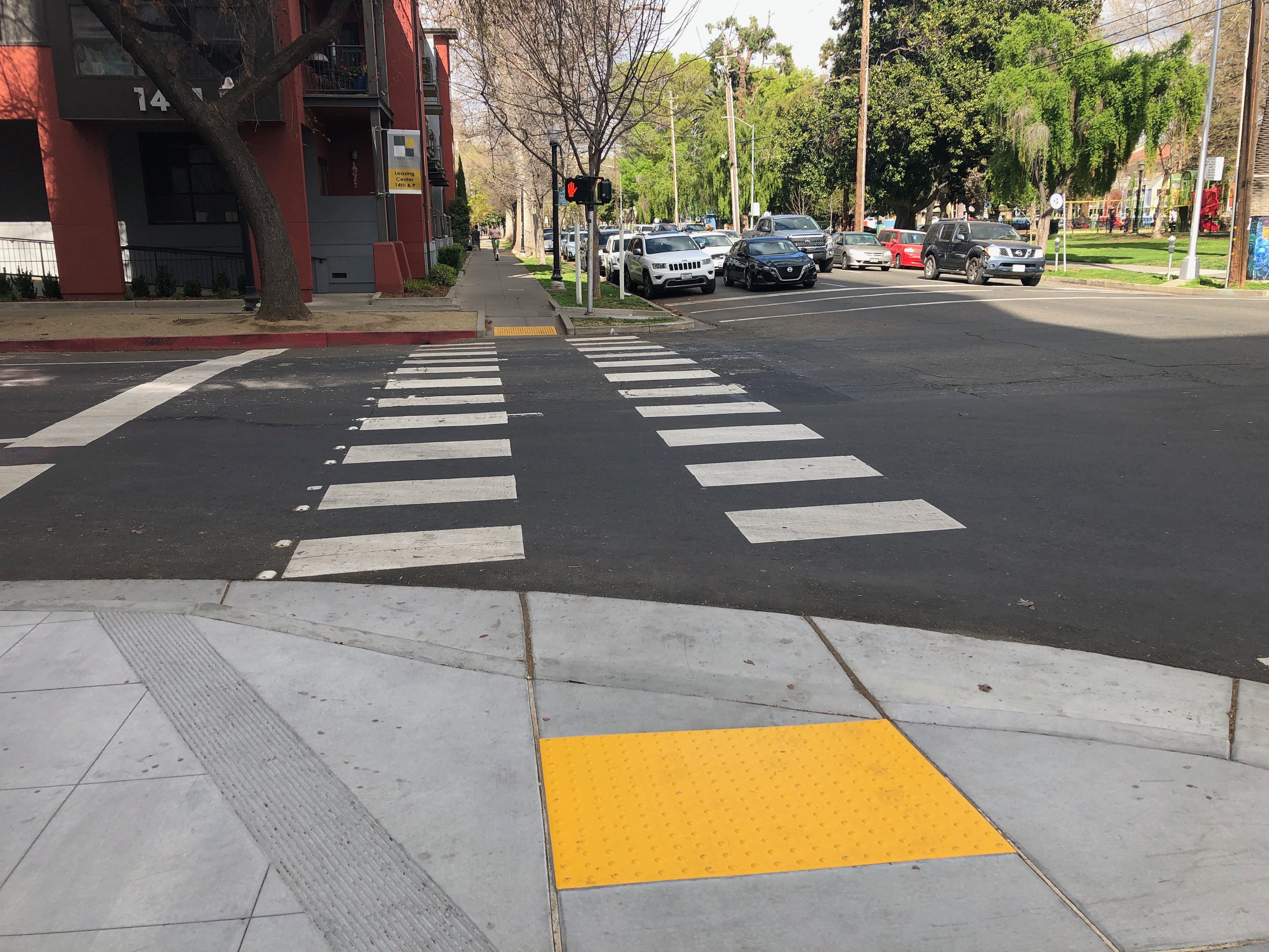
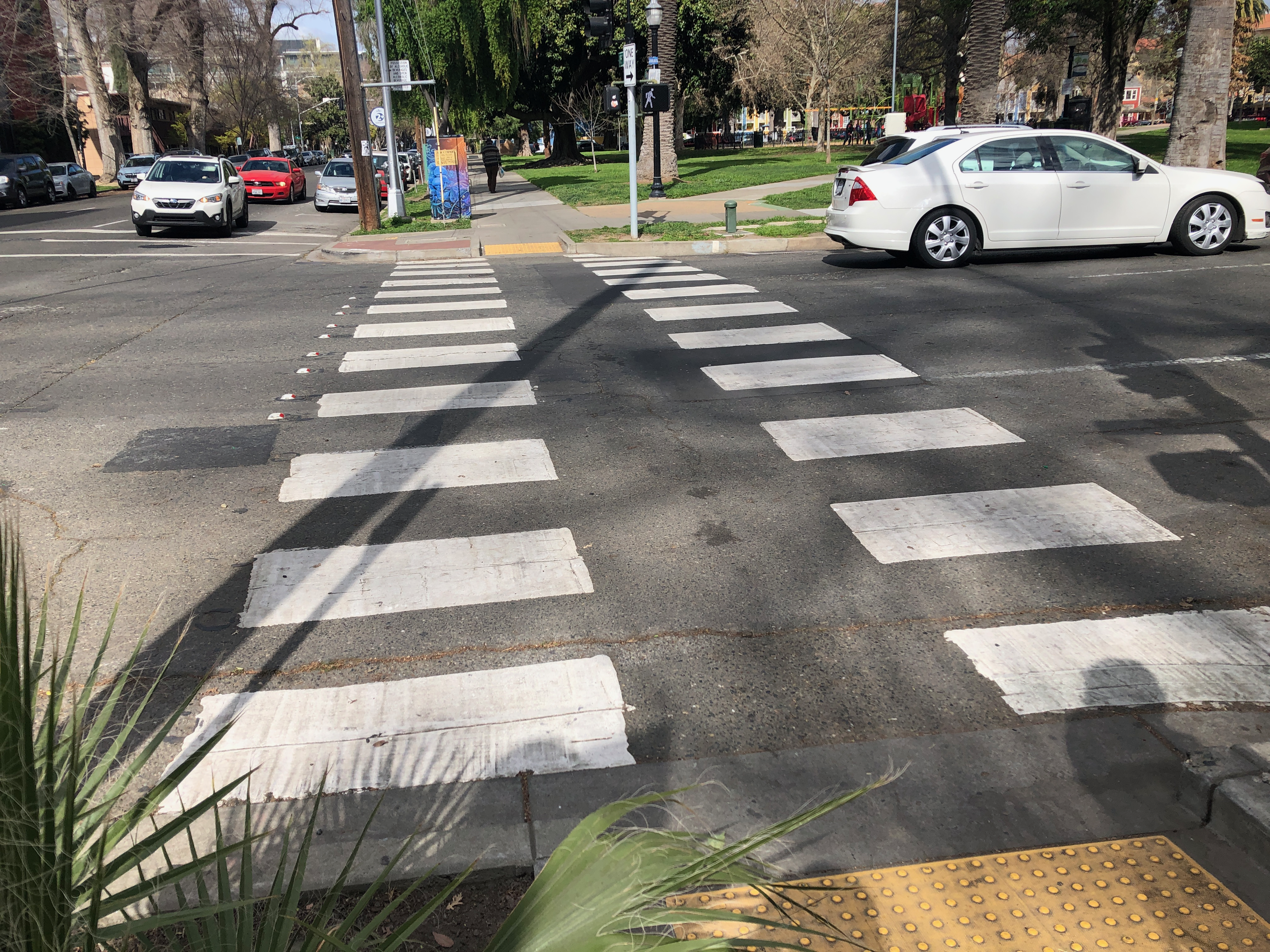
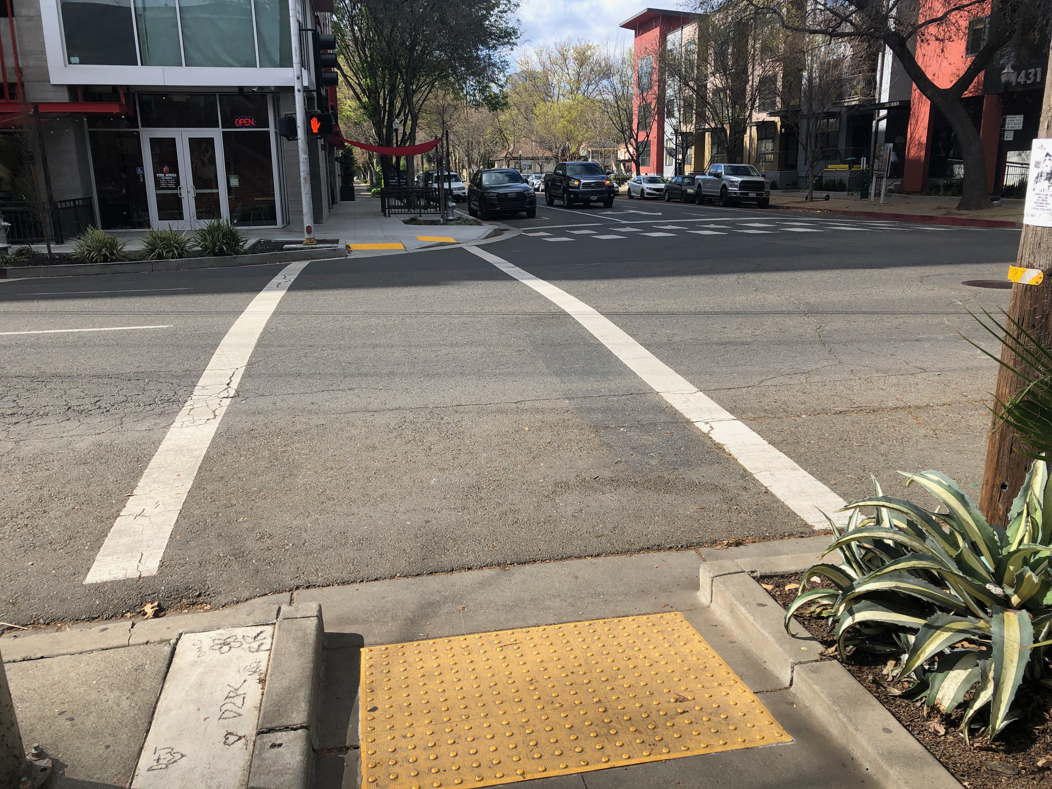
  • Paint high visibility crosswalks on the north and south legs of the intersection, similar to what the west and east legs already have. Sacramento is nearly unique in using these split crosswalk patterns, but they are probably as safe as any other high visibility pattern, which are often called Zebra crosswalks.
  • Create red curb offsets for each of the four corners, in the upstream direction. For 15th Street southbound, that means removing the last parking spot before the intersection on the west and east sides. For Q Street eastbound, that means removing the last parking spot before the intersection on the north and south sides. There is already an offset on the north side, and a small offset on the south, but it should be longer. You will notice in the photo above that there is a car stopped illegally in this area on the south side.
  • Immediately install temporary curb extensions on all corners. These extensions would fill the parking lane. Vertical delineators (posts or bollards) and paint (tan or purple is often used) set off this area. Why temporary? Temporary is low cost, and allows observation of how the installations are used by walkers, bicyclists, and drivers. The corner radius actually needed can be determined before any permanent installation.
  • Observe the temporary extensions, and then design permanent extensions with hard curbs and sidewalks. The permanent extensions must consider bike facilities on both Q Street and 15th Street. Q Street up through 14th St has a parking protected separated bikeway on the left side, and it is assumed that this will be continued to the east. 15th Street should have a parking protected separated bikeway on one side or the other, and the city will have to determine which side before installing permanent extensions. The curb and sidewalk extension on the west side of 15th Street south of Q Street may indicate the city has already made that decision, or it may be an oversight.

The photos below show crosswalks and offset locations for the intersection.

Sac Vision Zero intersections & red light cameras

I’ve written previously about Vision Zero high injury intersections in the City of Sacramento: Sac Vision Zero new intersections map, Sac Vision Zero top intersections all modes, Sac Vision Zero top ped intersections, Sac Vision Zero Top 5 Corridors and top intersections, and Sac Vision Zero flaws.

The City of Sacramento has red light cameras at the following locations:

  • Mack Road & La Mancha Way/Valley Hi Drive
  • El Camino Avenue & Evergreen Street
  • Howe Avenue & Fair Oaks Boulevard
  • Mack Road & Center Parkway
  • Exposition Boulevard & Ethan Way
  • Broadway & 21st Street
  • Folsom Boulevard & Howe Avenue/Power Inn Road
  • Arden Way & Challenge Way
  • 5th Street & I Street
  • 16th Street & W Street
  • Alhambra Boulevard & J Street

The top injury intersections are:

  • Stockton Blvd & Broadway
  • Stockton Blvd & Lemon Hill Ave
  • Stockton Blvd & 47th Ave & Elder Creek Rd
  • Watt Ave & Auburn Blvd
  • Del Paso Blvd & Evergreen St & Lampasas Ave
  • Julliard Dr & Kiefer Blvd & Folsom Blvd
  • Power Inn Rd & Fruitridge Rd
  • Freeport Blvd & Florin Rd
  • Center Pkwy & Cosumnes River Blvd
  • Bruceville Rd & Cosumnes River Blvd
  • Franklin Blvd & Mack Rd

Notice there is no overlap. One could optimistically say that the presence of red light cameras may be making drivers safer and reducing the crashes at these locations. But I doubt it. More likely, the city is just not prioritizing high injury intersections. Of course high injury intersections change over time, as traffic patterns change, and as the city redesigns intersections to be safer, so red light camera locations need not remain static.

I ask that the city install red light cameras at all the high injury intersections. I am not asking that the city move the existing cameras to the new locations. If someone thought a red light camera was necessary at an intersection, it probably still is, and should continue unless evidence indicates otherwise.

A lot of driver-apologists claim that red light cameras are not fair, that they are installed mostly to gain ticket revenue, and that they aren’t accurate anyway. Yes, some places have installed cameras for funding, but Sacramento is not one of them. Yes, sometimes the camera systems flag a vehicle that is not running a red light, but the photos are reviewed. Even if the city were making $1M a day on red light cameras, that would be just fine with me if it prevents one death. I value life more highly than do many drivers.

I worked in Citrus Heights for several years, which has a much higher percentage of traffic signals complemented by red light cameras. My perception is that it really did make a difference. I saw very little red light running in Citrus Heights. Other violations, sure, but not red light running.

photo from City of Sacramento Red Light Running Program page

too many traffic signals?

I just finished reading Confessions of a Recovering Engineer by Chuck Marohn of Strong Towns. I’ll have more to say about the book soon. The reading reminded me of a number of things I’ve wanted to write more about, and one of those is traffic signals. Chapter 7, Intersections and Traffic Flow.

“Traffic signals are the most mindless and wasteful thing Americans routinely install to manage traffic. Removing nearly all of them within cities would improve our transportation systems and overall quality of life.”

Chuck Marohn, Confessions of a Recovering Engineer

I have long wondered what the value of traffic signals really is. As a walker, they make me wait for the signal cycle when there is no traffic coming. As a bicyclist, they stop me at almost every location, because they are set for the speed of cars, not the speed of bicyclists. There are places that set signals to work for bicyclists, but nowhere in the Sacramento region. Of course as an enlightened walker and bicyclist, I wait only for gaps in traffic and not for the signal to change. As a driver, which I once was, they make me sit at an intersection when I could be moving, and slow overall travel time.

Most signals do not sense traffic loads and respond. They are on a cycle, no matter what. Rush hour, midnight, same cycle. Signals are timed to preference one direction of traffic over the cross-traffic. And they are often very slow cycles. In the county, many of the signals are on a 2.5 minute cycle, and even in urban areas they are on a slow 1.5-2 minute cycle. Drivers have come to accept the long wait, but for walkers and bicyclists for whom a red signal can increase overall travel time by 1-1/2 to two times, they make us crazy.

Signals do not slow the speed that drivers drive. Drivers wait at the red light, and then accelerate on the green to make up for wasted time, always going over the posted speed limit. Of course these days many drivers don’t stop for red lights at all, they go through intersections on stale reds (meaning it was red before they even entered the intersection). This has become a very common behavior over the years, and is almost routine since the pandemic.

One of the things that signals seem to do is shift unsafe driving behavior from intersections to corridors, the street parts in between signals. Instead of misbehavior at intersections, causing lower speed crashes, we get misbehavior in between, with higher speed crashes.

Everyone who walks knows that signalized intersections are not safe places to cross the street. Drivers turning right look only for opposing traffic, almost never for people in the crosswalk. When the light turns green, drivers accelerate into right hand turns, across the crosswalk and any walkers in it. For intersections that permit left turns on green lights, the threat of a left turning driver crossing the crosswalk at high speed is constant. So people who value their life tend to cross mid-block, where one only has to look for two directions of traffic instead of 12.

The Confessions book suggests several alternatives to traffic signals, including roundabouts, traffic circles, and shared space intersections.

  • Use roundabouts rather than traditional intersections. Of course in place where the size of intersections is constrained by right-of-way and adjacent buildings, a real roundabout may not be possible, but traffic circles, of which the central city already has a number, can fit. Traffic circles are not as effective as roundabouts, but can replace signals.
  • Slow traffic enough that people can cross streets without having to have signals to interrupt traffic.

I realize that many people associate signals and stop signs with safety, and often demand signals and stop signs when the streets are dangerous. So what I am going to say here will be controversial. For people who think traffic signals make things safer, please spend some time observing at both signalized intersections, and unsignalized intersections. Are the ones with signals really safer? For anyone?

One of my (not) favorite signals is at 15th Street & E Street. At this point, 15th Street is not a collector or arterial, it only becomes one-way a block earlier at D Street, and has very little traffic at this point. It does not become a higher volume street until H Street and I Street to the south. E Street is a collector, though not a very busy one. Yet the signal cycles all day long, with almost no traffic at it. A perfect location for a traffic circle. Not the point of this post, but 15th Street at this location does not need two lanes, one lane would be plenty, and the excess lane can be converted to diagonal parking and/or a bike lane. A photo of the intersection is below, showing a typical amount of traffic.

What about all the signals on 14th Street? This is a low volume, fairly low traffic speed street, at all times of day. It dead-ends at the convention center, so it is not really even a through street, yet it has five signals. There are a lot more such examples. You can add yours in the comments!

15th St & E St intersection, Sacramento

All the signals in the central city that are not at the intersection of collector and/or arterial streets should be slated for removal. If the city wishes to do so, it could do a traffic study before removal, or just go ahead with removal, but it should not be leaving these signals in place without action. There are options short of complete removal. Signals could be made into signalized pedestrian crossings, so that when people walking need to cross, they still have (some) protection of a red light. (Some protection. Again, many drivers to not stop at red lights.) Curb extensions can be installed to shorten crossing distances. Traffic diverters (modal filters) can be installed so that only bicyclists have a thru route. And of course roundabouts and traffic circles. At the intersection of two collector streets, a four-way stop might be appropriate. Each intersection is unique, but each one is also a candidate for change that makes travel safer and less frustrating no matter the mode of travel.

I’m not suggesting, at this time, the removal of signals at the intersection of collector and/or arterial streets. Someday.

The map shows these signal locations, with a red X (pdf). The intersections of collectors and/or arterial streets, not marked here, are not being challenged at this time. The purple streets are designated collectors or arterials by the city (part of the Functional Classification System).

signals in Sacramento central city for possible removal

Sacramento bike superhighways

As a follow-up to the Sac Transportation & Climate Workshop big idea of bike superhighways, I was curious about how the proposed alignments matched with low income and high minority communities in Sacramento.

The map presented at the workshop is low resolution, but I decided to see if I could reproduce the routes, using a combination of the city’s existing and proposed bike network data, the road network where the proposals didn’t seem to match the bike plan, and just plain guessing. You’ll notice gaps and places where the alignment may not be correct, but overall it provide an good impression of the proposal. It is interesting that some of the on-street low-stress bikeways routes are not in the current city bike master plan.

The demographics data for low income high minority communities is from SACOG’s Environmental Justice Areas. This is just one of many possible comparisons. Population density and employment locations would also be interesting. I don’t know what demographic information the city used to come up with the bike superhighways proposal.

The map is below, and pdf. The red lines are the bike superhighways, the blue lines are the ‘on-street low stress bikeways’ that provide to some degree the connection from the bike superhighways to the central city.

bike superhighways and LIHM areas in City of Sacramento

Does the proposal serve the people who need to be served? Meh. To some degree. The Sacramento Northern Parkway, at upper right, probably does the best. It is an existing separated path (Class 1) that does need upgrades at road crossings but otherwise is ready to go. The Jackrabbit Trail at the upper left does serve high minority areas, but not low income. It is mostly an existing route, with some gaps and several completely unsafe roadway crossings. The south area is a major bikeway desert, of course, due to both city and county disinvestment and transportation discrimination, and this proposal does little to correct that.

Measure 2022: Southeast Connector exceptionalism

A group calling themselves A Committee for a Better Sacramento is sponsoring a citizen-initiated ballot measure for the November election, titled “Sacramento County Transportation Maintenance, Safety, and Congestion Relief Act of 2022—Retail Transactions and Use Tax”. (Note: Some people are referring to this as Measure A, but measure letters are assigned by county elections, not by the sponsors. I’ll continue to refer to it as Measure 2022, for now.)

One of the major projects in the measure is the Capital Southeast Connector, a new freeway from Folsom to Elk Grove. Future posts will talk about what a bad transportation idea this is, but for now, what a bad part of the measure it is.

The measure essentially makes the Capital Southeast Connector JPA the judge of whether the project meets air quality requirements – the fox watching the henhouse. It is somewhat obscure what the language means, and takes a close reading, but the gist is that if the project fails to meet air quality requirements and therefore is not included on the project list in the MTP (SACOG Metropolitan Transportation Plan), the JPA can go its own way and decide for itself that the project meets requirements.

K. Metropolitan Transportation Plan & GHG Reduction Targets. The Sacramento region Metropolitan Transportation Plan/Sustainable Communities Strategy (MTP) currently requires that the region meet a 19% per capita greenhouse gas (GHG) reduction target. Expenditure Plan projects that are planned or programmed for construction in an MTP, as may be amended from time to time, shall be eligible for Measure funds. Expenditure Plan projects not planned or programmed for construction in an MTP shall be eligible for Measure funds if the construction phase of the project is exempt from project-level and regional level air quality conformity.

For any non-exempt projects that are not planned or programmed for construction in an MTP, as may be amended from time to time, the following requirements will apply:

For any non-exempt projects that are not planned or programmed for construction in an MTP, as may be amended from time to time, the following requirements will apply:

1. In order to meet the then applicable regional GHG reduction target for the MTP, project sponsors (parties) shall develop mitigation measures for any project(s) that increases GHG emissions.

2. If the parties can mitigate any such project impacts to maintain adherence to the then applicable regional GHG reduction target, the project(s) shall be eligible for Measure funds.

3. If the GHG impacts are not mitigated to meet the region’s then applicable GHG reduction target, and as a result the region cannot meet its applicable GHG target, the funds planned for the non-exempt project(s) may be used by the corresponding Implementing Agency at their discretion, for other than the originally intended project(s), provided any alternative project(s) are consistent with the Expenditure Plan and included in an MTP, as may be amended from time to time, that meets the then applicable target. Per above, alternative project(s) not planned or programmed for construction in an MTP shall be eligible for Measure funds if the construction phase of the project(s) is exempt from project-level and regional-level air quality conformity.

Measure 2022, Exhibit A, Chapter 1, Section K

This treatment of the JPA might very likely be found to be unconstitutional, but the measure proponents have thought of that too:

If any portion of this Measure is held by a court of competent jurisdiction to be invalid, we the People of the Sacramento Transportation Authority indicate our strong desire that: (i) the Authority use its best efforts to sustain and re-enact that portion, and (ii) the Authority implement this Measure by taking all steps possible to cure any inadequacies or deficiencies identified by the court in a manner consistent with the express and implied intent of this Measure, including, to the extent permitted by law, adopting or reenacting any such portion in a manner consistent with this Measure.

Section XII, Paragraph B, of the potential measure

In other words, if we, the sponsors included something illegal or unconstitutional in this measure, we expect the Sacramento Transportation Authority to defend the measure and make sure it all gets implemented.

To mitigate the immense GHG/VMT (greenhouse gas emissions / vehicle miles traveled) generated by the Connector, the measure proposes Transit and Rail Congestion Improvement Projects. With somewhat less money allocated to this than the Connector, these expenditures might make up for the harm of the Connector, but would not address any other needs in the county. It also proposes BRT features for the Connector, which is ridiculous as this is the last place in the county that a transit agency would propose BRT.

If the Connector, as a whole or in the piecemeal projects by which is has already been partially constructed, causes the region to not meet its legally required greenhouse gas reduction target of 19%, the entire region would therefore be under non-compliance, and therefore ineligible for federal grants.

The proponents see the value of the Connector as enabling greenfield development in the southeast area of the county. Though touted as a solution to congestion on Hwy 50 and Hwy 99, it will not be. What it will do is encourage long distance commuting between El Dorado County and Elk Grove, and generate VMT trips due to the greenfield developments along the corridor. The Connector will not turn out to be a boon to Folsom, Rancho Cordova, and Elk Grove, but yet another congested highway, sucking value away from the cities and citizens.

Search for category Measure 2022 to see posts as they are added.

Strong Towns approach to public investment

This is a follow-on to my post don’t forget the little things. Though my post doesn’t have the same message, it goes back to the idea presented by Strong Towns, that big projects are not the secret to improving communities, but small steps, refined and repeated. This applies just as much to transportation as anything else.

Strong Towns has informed my thinking about transportation in ways that I’m not always aware of and acknowledging, so here is a start. If you care about the livability of your community, and the financial stability of your city/county/state, I cannot more highly recommend the organization.

The Strong Towns Approach to Public Investment

ECOS presentation on sales tax measure

Tonight (March 10, 2022), the ECOS Climate Change Committee received a presentation on the potential transportation sales tax measure (which I’m calling Measure 2022, until it receives an official name). The presentation was given by Roger Dickinson, who was a member of the state Assembly and the Sacramento County Board of Supervisors. It was very well presented, concise and on topic. My summary will not cover all the points of the presentation and following discussion, but I think will interest people who are starting to follow the potential measure.

Roger said the measure is very much like the 2020 measure which was not placed on the ballot: 1) fix-it-first; 2) solving congestion; and 3) transportation alternatives. But there are some poison pills included in this measure that were not in the 2020 measure, specifically the Capital Southeast Connector and related issues.

The language included in the 2020 measure to make sure the Capital Southeast Connector complied with air quality requirements of the SACOG MTP/SCS (Sacramento Area Council of Governments Metropolitan Transportation Plan / Sustainable Communities Strategy) was removed. This language was specifically worked out by Sacramento Mayor Darrell Steinberg as a compromise to ensure the city’s support for the measure. The removal is likely to ensure opposition from Steinberg and others in the city. The potential measure essentially makes the Capitol Southeast Connector JPA the judge of whether the project meets air quality requirements – the fox guarding the henhouse. More on this in an upcoming posts.

If the Connector causes the region to not achieve the legally required 19% reduction in greenhouse gas emissions, the region will be non-compliant and likely not eligible for federal transportation grants.

Discussion that followed Roger’s presentation largely revolved around two issues: 1) is it possible to stop this measure, before or after it makes the ballot, and what would that take?; and 2) should the measure be opposed even though it is likely the only significant source of match funding for SacRT grant applications to advance capital projects including light rail modernization, light rail extension, and BRT (bus rapid transit) corridors?

No answers yet, but this will likely be a major topic of conversation within and among all the transportation advocacy and equity organizations in the county, for many months to come.

Scooters filling bike racks

Here is another antique post that was not posted, but more recent, from 2021. As an update, this is slightly less of a problem today than it was. The city has enforced the requirement that only permit holder Lime (bikes and scooters) can deploy to the racks that were installed by JUMP for the JUMP Bike program. The photo below shows one of those racks. There are also many more scooter and bike parking areas (outlined in white, with symbols, but without racks). With this, I’ve cleaned out my drafts folder.

Rentable scooters, called shared rideables by the city, are thick as flies in Sacramento central city. They are being deployed to bike rack areas, completely filling the racks and leaving no space for bikes. The photo shows a rack with each space occupied by a scooter, no spaces available. It also illustrates a JUMP rack at which other companies are deploying their scooters. These JUMP racks, and the trapezoidal racks, were purchased for the original SoBi and later JUMP systems, and so ‘belong’ to the JUMP/Lime system.

Individuals are free to part their own bike or scooter, or any bike scooter they rent, at these racks, but the other companies are prohibited from deploying to them.

And there are simply too many scooters in some areas, particularly Old Sacramento and R Street. Lime, Bird, Spin, and Razor, are deploying more scooters to high demand areas than can possibly be rented in a day. I assume that they are trying to drive each other out of business so they can dominate and raise prices, which is the business model for all app-based companies. In some ways, a fallout would be good, but in the meanwhile, the huge number of scooters is occupying public space, the sidewalks, and reducing livability.

Measure 2022: ouch!

A friend pointed out the statements of support for the transportation sales tax measure which are scrolling on the A Committee for a Better Sacramento home page. These are all local politicians, and mostly well respected.

I’m disappointed. They seem to have bought into two falsehoods: 1) congestion can be solved by adding roadway capacity, and 2) congestion is a significant contributor to air pollution. I wonder if they actually read the measure with a skeptical eye before signing on. There are enough things wrong with the measure to fill up many blog posts. I hope to be able to convince these people to become neutral on the measure.

Funding generated by this initiative will enable us to complete the Capitol Southeast Connector project that will connect Interstate 5 to Highways 99 and 50 and link the Cities of Elk Grove, Rancho Cordova and Folsom to relieve congestion, improve safety and drive future economic growth.

David Sander, Chair, Capitol Southeast Connector Joint Powers Authority (also member of the Rancho Cordova City Council)

This initiative will provide a blueprint for transforming our transportation system in the decades ahead and enable us to leverage billions in state funding to help us achieve our aggressive goals.

Bobbie Singh-Allen, Chair, Sacramento Transportation Authority (also Mayor of Elk Grove)

Improving the County’s transportation system will create significant progress towards improving our air quality and addressing climate change. Less congestion will reduce transportation emissions and increased ridership on public transit will add to the positive impact to our air quality. Additionally, the measure invests tens of millions into essential air quality measures.

Eric Guerra, Sacramento Air Quality Management District (also member of the Sacramento City Council)

This initiative will create major benefits to our light rail and bus system. Having additional local funding will help secure millions in federal and state funding to expand the system, modernize our fleet, reduce greenhouse gases and improve congestion on our roadways.

Steve Miller, SacRT Board Chair (also member of the Citrus Heights City Council)

Search for category Measure 2022 to see posts as they are added.

Measure 2022: no public engagement


A group calling themselves A Committee for a Better Sacramento is sponsoring a citizen-initiated ballot measure for the November election, titled “Sacramento County Transportation Maintenance, Safety, and Congestion Relief Act of 2022—Retail Transactions and Use Tax”. (Note: Some people are referring to this as Measure A, but measure letters are assigned by county elections, not by the sponsors. I’ll continue to refer to it as Measure 2022, for now.)

It has been relayed from others that the committee did not feel that it needed to do any public engagement before developing the text of the measure. The rationale is that since the Transportation Expenditure Plan (TEP) is very similar to that proposed in 2020, and before that in 2016, that is all the public engagement necessary. The TEP was indeed approved by the county and city councils, but there was no real public engagement on the issues. Transportation engineers and planners developed a wish list, and the government bodies adopted it without analysis. Except in the City of Sacramento, where the council challenged the plan developed by Public Works, and demanded a plan that better addressed the needs of the citizens and critical issues such as climate change and equity. None of the other entities did this. So the overall TEP is essentially a list of pet projects of the engineers and planners, developed without any real criteria and without reference to the desires of the community. Some board and council members will claim that they know what the public wants, and their approval is all that is necessary. But the fact is, they never asked the public what they thought.

So, the committee is running with that. No public engagement. This is a citizen-led measure, but the committee decided they didn’t need to hear from anyone else. No meetings, no outreach, no nothing.

We do not know who the committee is, and won’t know who it is until they file the measure with county elections, due July 18. I guessing since they have posted the measure and their sponsors on their website, not listing committee members is likely an effort to hide that information from the public. They will be gathering signatures between now and when they submit. I ask that you not sign their petition. To bring up the old adage: “No taxation without representation.” Therefore, no public engagement, no measure, no taxes.

Search for category Measure 2022 to see posts as they are added.