Is sales tax for transportation the wrong approach?

There are three ideas for transportation funding floating around, for the 2026 ballot, though none have been formalized. All rely on sales tax.

  • Sacramento Transportation Authority (SacTA) may create a ballot measure to fund transportation. It would be in addition to the existing Measure A, and might fund transportation infrastructure for infill housing, which has not been done before. As an agency-sponsored measure, it would require 2/3 vote to pass.
  • Sacramento Metro Rail and Transit Advocates (SMART) and Mayor Darrell Steinberg have drafted measure that would fund active transportation, transit, and housing. It would probably be for the county, but could be just for the City of Sacramento. As a citizen initiative, it would require only 50% + 1 to pass, a much more achievable vote.
  • SacRT it considering a measure for transit and related active transportation that might cover only a part of Sacramento County, the more transit-supportive part, probably the cities of Sacramento and Elk Grove. As an agency-sponsored measure, it would require 2/3 vote to pass.

Sales taxes are regressive, meaning that low-income people pay a much larger percentage of their income to sales tax versus high-income people. Most organizations which lead with equity are opposed to further sales tax increases, feeling that enough is enough.

In Sacramento County, with a strong anti-tax voice in the low density unincorporated county, it is difficult though not impossible to reach the 2/3 threshold. The 2016 transportation sales tax fell short of 2/3. Measures to fund schools districts are more likely to pass. A complicating issue is that Elk Grove recently passed a sales tax measure to fund many purposes, one of which is transportation. Folsom and Rancho Cordova have sales taxes for which it isn’t clear to me whether any goes to transportation.

General purpose sales tax measures, which may list uses but are not required to follow those lists, only require 50% + 1 to pass. That flexibility is both a feature and a danger, since a government may shift sales tax income from what they said it would be spent on to other purposes.

Though I have not heard parcel taxes being discussed, they are another source of funding, though they are also regressive because they are a flat rate per parcel, not based on the value of the parcel.

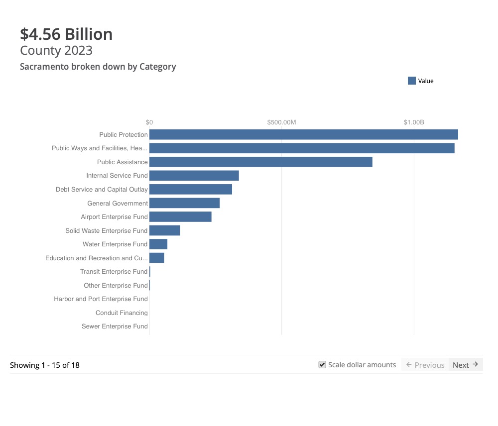
Two other types of tax which are progressive, meaning that high-income people pay a higher percentage of income than low-income people, are income tax and property tax. Income tax does fund transportation at the state level, but income taxes are not available to cities, counties, and special districts. Property tax can fund transportation, though due to Prop 13 which limits property tax, it mostly goes to schools and public safety. For Sacramento County in 2023, the chart below shows allocations. The ‘Public Ways and Facilities, Health, and Sanitation’ category goes mostly to Health, with Public Ways and Facilities being less than 20% of that category. This chart does not include school districts within the county, which also rely on property tax.

Transfer taxes, which are based on the value of a property when it is sold, are progressive. These have been discussed in a number of places in California, though not locally so far as I have heard. I am not aware of any existing transfer taxes that fund transportation, though they do fund a number of other government functions. The state levies a transfer tax throughout the state, and that income goes into the general fund.

Any county, city or special district can bond against property tax, meaning that they can expend money now and pay it back over time from future property tax income. Again, Prop 13 limits the usefulness of this by suppressing property tax income, but does not preclude it. If Prop 5 on the 2024 ballot passes, cities, counties, and special districts will be able pass bond measures with a 55% vote rather than 2/3 vote, though the proposition raises the bar on transparency and types of expenditures. Though Prop 5 is intended primarily to fund housing, it could fund transportation, and there is a logical nexus with transportation that supports housing.

For other posts on transportation funding, see category Transportation Funding.

bike share model for Sacramento

I was recently asked what model for bike share could work in the Sacramento region, given the recent pull-out of Lime, and the small fleet offered by Bird.

The current situation is:

  • SACOG no longer wants to be involved in bike share
  • it is not clear whether Sacramento Metropolitan Air Quality Management District wants to be involved
  • private bike share companies have pulled out of Sacramento twice now, without notice to the permitting agencies nor users
  • privately owned and operated bike share systems are struggling in many cities, and they have either ended or cut back
  • City of Sacramento does not want to be involved in managing bike share beyond issuing permits; it isn’t clear whether West Sacramento wants to
  • Davis, under a partnership between UC Davis and the City of Davis, has a bike share system operated by Spin, and was not part of the SACOG program before it ended
  • when the system was in operation, it covered only parts of Sacramento and West Sacramento, excluding many lower income neighborhoods
  • discount programs offered by Lime, and still by Bird, are important, but are meaningless if bikes are not available in low income neighborhoods

It is clear that the privately owned and operated model is not working, and will not work, for Sacramento and West Sacramento. I believe that bike share is an integral part of our transportation system, and it is the responsibility of the transportation agencies to ensure that there is viable bike share in urban areas. So what model might work? Please understand that I do not have special expertise in bike share programs, beyond having used the local ones extensively, used systems in several other cities, and in fact was a primary enabler of the SoBi and initial JUMP systems by rebalancing bikes when the companies were understaffed to do so. I encourage you to look at NACTO’s Bike Share and Shared Micromobility Initiative and Shared Micromobility in 2022 to educate yourself about bike share.

Note: I am not addressing scooter share. My observation of scooter share is that it mostly replaces walking trips, and therefore has no VMT reduction value. Bike share seems to be used mostly to replace motor vehicle trips. Therefore bike share is the important issue to be solved.

My model

  1. Bike share would be publicly owned, including bikes, bike parking areas and racks, and docks or charging infrastructure if that turns out to be the system model.
  2. Bike share would be privately operated under contract with a public agency. The private company would be required to give a minimum of 60 days notice to terminate the operation.
  3. The best public entity to own and contract the system in the Sacramento region is SacRT. I don’t say this because SacRT has any expertise or competence in bike share, but because they are the one regional entity that covers nearly all of Sacramento County, and might be interested, and through MOU, could cover West Sacramento as well (Yolobus is likely to eventually be annexed by SacRT, but the two agencies already cooperate). There is a nexus between transit and bike share, because bike share fulfills the first mile/last mile needs of many riders. Bike share locations would not be limited to transit stops, but that would be one of the criteria for system design and bike locations.
  4. SacRT, or other entity, would contract with a private company with experience in bike share management to operate the system. It is also possible that a nonprofit might be created to operate the system, as this has been a successful model in several cities, particularly as private systems failed.
  5. The system would be operated in areas with enough residential or commercial activity to justify productive and profitable (for the private operator) operation. Since there are such areas outside of the cities in the county, and since there are also areas within the cities that are too low density to justify bike share, it does not make sense for operations to be contracted by the cities. Criteria for successful areas would have to be developed, and adjusted as appropriate.
  6. There is a role for the cities, and the counties, to fund bike share infrastructure. Though grants are a possibility, there are no existing and reliable sources of funding for the publicly owned system. Either the cities and counties fund it, or it doesn’t happen. Once the system is in operation, there may be enough ‘profit’ to maintain and upgrade the system, so that the cities and counties might not have to supply ongoing funding. Or it may require ongoing subsidy.
  7. The private operator would be subsidized by an amount subject to negotiation, for perhaps two years, but the system should not need ongoing subsidy. The initial subsidy would cover the start up period during which the system would rebuild knowledge and support among the users. The withdrawal of LIme, and JUMP/Uber before that, has certainly damaged the reputation of bike share, and the new system will have to rebuild trust.

There are three types of bike share systems:

  • Docked: Bike must be returned to a dock after use. Docks are provided in areas of higher use.
  • Undocked: Bikes can be parked anywhere, though them must be locked to a rack or within a designation parking area.
  • Hybrid: Bike may be returned to a dock or hub, or parked elsewhere. JUMP had a highly successful hybrid system, where users were rewarded for returning bikes to a charging hub, but could park elsewhere. The bay area Bay Wheels is hybrid for pedal assist e-bikes (not regular bikes) in that they can be parked away from docks for a small fee.

There are plenty of other issues to resolve before we get to which type of system, but I provided that for people who will ask. Each system has its advantages and disadvantages, and its proponents and detractors.

Your thoughts? Have at it.

Four boards meeting

On November 9, 2023, the boards of four agencies met together for the first time: SACOG (Sacramento Area Council of Governments), SacRT (Sacramento Regional Transit District), SMAQMD (Sacramento Metropolitan Air Quality Management District), and SMUD (Sacramento Municipal Utilities District). This is probably the largest gathering of elected officials in one room in Sacramento history. Of course the number was not as great as you might think, because many officials serve on multiple boards. The SMUD board is independently elected, while the other three boards are composed of elected officials appointed to the boards by their own boards or councils.

The agenda for this meeting and the resolution that was passed are available here. The reason for the meeting was to advance collaboration among the boards to further mutual objectives, and to pass a resolution stating that. The staff of these agencies already collaborate to some degree, but also don’t on some important issues.

There was a long discussion period before passing of the resolution. No surprise, many of the smaller cities dominated the discussion, as is the case with SACOG board meetings. Several electeds used the time to promote commercial concerns that they benefit from, which is a really sad statement on the quality of our elected officials. Probably 90% of the discussion was devoted to electric vehicles, and in fact it looks as though seeking grant funding for more electric vehicle infrastructure was the real reason for the meeting. Grant applications with multiple agencies on board are more likely to receive funding. There was also discussion of managing forest lands for carbon sequestration and need to manage forests to reduce severe wildfire carbon release. And a few other topics. Active transportation was not one of them.

The boards tried to cut off public comment, but this caused an uproar and several citizens were allowed to speak (if they had been prevented, it would have invalidated the whole meeting under the Brown Act). Of course I spoke, and made the following points:

  • Where is Sacramento Transportation Authority? SacTA probably has more effect on carbon emissions that any other agency in the region, but was not represented. I later learned they were not invited.
  • The discussion and collaboration is about money, money, money, but should be about policy, policy, policy. What are the policies that the agencies can agree on? Money should follow policy, not control it.
  • The strong focus on motor vehicle electrification is techno-glitter, and results in deemphasizing:
    • safe walking: no mention was made of the needs of walkers for safety from motor vehicles
    • bike share: no mention was made of bike share, or scooter share for that matter
    • electric bikes: no mention was made of electric bikes during the discussion; bikes are the most important solution to the climate crisis, but one that the agencies seem particularly disinterested in
    • reducing VMT: the discussion was mostly about electrification, with very little about reducing VMT (vehicle miles traveled), though all reputable sources indicate that it will be necessary to reduce VMT along with electrification
    • land use: no mention was made of land use; though none of these agencies have direct control over land use, their expenditures affect land use and are affected by land use; the climate crisis cannot be solved without changing our land use patterns, but all of the smaller cities, and the counties, want and hope to ignore this fact

I finished up by talking about my experience with bike parking at the venue, which was the Sacramento State Alumni Center. When I rode up, there was no bike rack on the north side of the building, so I locked up to a parking sign. Exploring around I noticed a wave rack on the south side of the building. Wave racks received a ‘not recommended’ status from the Association for Pedestrian and Bicycling Professionals, which is the national standard, about ten years ago. Yet that is all the university provides. There are acres of car parking north of the building, and acres of parking south of the building. The university does have two dedicated bike parking compounds, but neither are close to the alumni center. The pathway along the south side of College Town Drive is nice, though substandard, but it ends at the intersection with Stadium Drive, where the alumni center is located. This is what we get when we focus on the needs of motor vehicle drivers, and place them above other users of the public space. This is what got us into the climate crisis, and we will not get out of it until we change that focus.

TIRCP grants for Sac region

TIRCP (Transit and Intercity Rail Capital Program) grants for 2022 have been announced, with two in the Sacramento region. One is a joint application from Capitol Corridor JPA, City of Sacramento, SACOG, SacRT, and Downtown Railyard Ventures, for work related to Sacramento Valley Station realignment of light rail and buses. The second is for SacRT to purchase eight more modern low floor rail cars.


4. Capitol Corridor Joint Powers Authority (CCJPA), with the City of Sacramento, Sacramento Area Council of Governments (SACOG), Sacramento Regional Transit District (SacRT), and Downtown Railyards Venture, LLC (DRV)

Project: Sacramento Valley Station (SVS) Transit Center: Priority Projects
Award: $49,865,000
Total Budget: $95,050,000
Estimated TIRCP GHG Reductions: 156,000 MTCO2 e

This project delivers a set of interrelated projects to introduce better connectivity between modes at the Sacramento Valley Station, as well as redesigned commuter and intercity bus service to the SVS and Downtown Sacramento, that will increase ridership on both trains and buses. Project elements include design of a new bus mobility center to facilitate convenient transfers between modes, realignment of existing light rail tracks and construction of a new platform, construction of a new cycle track on H Street to improve access to the station, and construction of a new pick-up and drop-off loop.

The light rail tracks will be realigned into a loop with a new north-south oriented platform just south of the Steve Cohn Passageway entrance (about 450 feet closer to the rail tracks than currently, and only 100 feet from the future Bus Mobility Center), as well as a new double track alignment from the new platform to the intersection of F Street and 6 th Street. The construction of the new pick up and drop off loop at the station will allow more efficient transfers. The project includes installation of a new storm drain trunk line which will enable new transit-oriented development on key parcels next to SVS.

A new regional bus layover facility will be built in a 2-block portion of X Street between 6th and 8 th Street. The proposed facility will allow buses to layover in Sacramento between runs, improving bus efficiency and reducing vehicle miles traveled, as well as fossil fuel consumption. Initial users of the facility are expected to include El Dorado Transit, Galt-Sacramento SCT Link, Placer Transit, Roseville Transit, San Joaquin RTD, and Yuba-Sutter Transit.

The project will also support the consolidation of downtown regional bus routes, building on the study SACOG completed with 2020 TIRCP funding. Construction of shared stops between SVS and the future Midtown Amtrak San Joaquin and Altamont Corridor Express station will be completed, including the reuse of seventeen bus shelters from the Temporary Transbay Terminal in San Francisco. This component will also complete an unfinished portion of 5 th Street between Railyards Boulevard and North B Street as the most efficient connector for all north area buses to access the freeway to SVS and serve the new state office complex on Richards Blvd. That will provide the connectivity to implement 10 additional bus stops (5 northbound and 5 southbound) north of H Street. Commuter buses operated by Amador Transit, Butte Regional Transit, El Dorado Transit, Soltrans, Galt-Sacramento SCT Link, Placer Transit, Roseville Transit, San Joaquin RTD, Yolobus and Yuba-Sutter Transit will be routed along new shared northbound and southbound routes. This work will complement SacRT’s TIRCP-funded network integration to better integrate its service with intercity rail at both SVS and the future Midtown station.

The project will also purchase and install contactless EMV readers coordinated with the California Integrated Travel Project on rail and bus vehicles to allow fares to be collected through contactless bank cards and mobile wallets.

Ridership at Sacramento Valley Station is also expected to be positively impacted by the city’s housing policies, confirmed with a Pro-Housing designation by HCD, the first city to receive such a designation in the state. A significant amount of housing is expected to be added in the Railyards District, adjacent to the station area.

These plans will be developed in cooperation with many transit partners and agencies throughout the Sacramento region, and with additional technical assistance provided by the California Department of Transportation, in order to ensure integration of regional and interregional capital improvements and service.

Project is expected to be completed by 2025.

Key Project Ratings: Medium-High
Cost per GHG Ton Reduced: Medium-High
Increased Ridership: High
Service Integration: Medium-High
Improves Safety: Medium
Project Readiness: Medium
Funding Leverage:High
Multi-Agency Coordination/Integration: Priority Population Benefits: Medium-High
Housing Co-Benefits: High


15. Sacramento Regional Transit District (SacRT)

Project: Fleet Modernization
Project Award: $23,600,000
Total Budget: $47,200,000
Estimated TIRCP GHG Reductions: 44,000 MTCO2 e

Purchases 8 new low-floor light rail vehicles (LRVs) to further expand low-floor fleet operations on the light rail system. Over one-third of SacRT’s light rail fleet has reached the end of its useful life, and this investment leverages past TIRCP grants, as well strong local match, to help modernize the fleet.

Low-floor LRVs will produce operational efficiencies by speeding up train times and optimizing boarding convenience and safety along with increased capacity. They also will increase fleet reliability and reduce the number of shorter than planned trains need to be operated on the system. These are significant benefits to persons with disabilities, seniors, parents with strollers, and bicyclists, who will have more boarding options and increased boarding and alighting safety. These improvements are expected to support retaining and attracting new light rail riders, including residents of disadvantaged communities, who make up 30% of the population within SacRT’s service boundary.

The project also supports sustainable housing and land use development while providing meaningful benefits to priority populations by improving mobility and access to transit options. The project complements several TOD/joint development projects underway along the light rail corridors, including a surplus SacRT property near a station that was sold to an affordable housing developer who has entitlements and plans to begin construction on 128 units.

Ridership on SacRT is also expected to be positively impacted by further rollout of integrated contactless payment throughout the light rail and bus system, as well as by the city’s housing policies, confirmed with a Pro-Housing designation by HCD, the first city to receive such a designation in the state.

19 Project completion is expected by 2027.

Key Project Ratings: Medium-High
Cost per GHG Ton Reduced: Medium
Increased Ridership: Medium-High
Service Integration: Medium-High
Improves Safety: High
Project Readiness: High
Funding Leverage: Medium-High
Multi-Agency Coordination/Integration: Priority Population Benefits: High
Housing Co-Benefits: High

Serve on SacRT board

From our friends SacTRU and also noticed by Ridership for the Masses.

Mayor Steinberg is appointing a member of the private sector to the SacRT Board. This seat will replace one of the Sacramento City Council seats currently filled by Councilman Rick Jennings and will serve until the end of 2018. The member of the private sector would have full voting rights as a board member representing the city of sacramento.

Position: Seat A – A member of the private sector with an understanding of the importance of regional transit and public transportation.

Deadline to Apply: March 30, 2018 at 5:00pm

The requirements and selection process are vague, but all are encouraged to apply. We hope many qualified members of the community will apply and represent the needs of riders, and that this seat is not simply filled by an interested member of the business community.

Apply at: http://www.cityofsacramento.org/Clerk/Legislative-Bodies/Boards-and-Commissions. Scroll down to Sacramento Regional Transit Board; no direct link is available.

It has been suggested that the best candidate is a woman of color. There is only one woman serving on the board currently, Linda Budge. There are two people of color, Rick Jennings and Phil Serna, but it is Rick Jennings seat that is being offered (see board list). STAR believes it is important to have someone who is a regular user of the transit system, since the current members range from low transit use to no transit use. Finding that ideal candidate that increases the diversity of the board and better represents riders will be a challenge. If you know that person or those people, please let them know and ask them to serve.

At the same time, STAR encourages everyone to apply. This can be a transformative moment for SacRT, and a strong interest in the position may encourage the other entities, county and cities, to appoint citizens. The board suffers from having politicians as members who are already very busy with their other boards and commissions, and other interests, and don’t pay enough attention to transit. We need someone whose passion is transit that works for everyone.

SacRT and employment

I earlier produced maps showing how SacRT routes related to population density and income (SacRT with income and population). I also wanted to present a map on employment or jobs – where people are going to on the transit system. It took much longer to track down that data, and I needed help from SACOG’s GIS staff. The employment data is from the Census Bureau’s Longitudinal Employment-Household Dynamics (LEHD). The data is normalized over area. The map is below, with the SacRT_employment pdf also available.

Read More »

SacRT frequency and stops

Two more maps for your viewing pleasure.

The route frequency map classifies routes by their frequency of service, as 12, 15, 20, 30, or 60 minute frequency. Mostly, this means service from 6:00AM to 7:00PM, though it is shorter in a few cases and longer in several cases. Peak only routes are not shown at all. Map below and pdf SacRT_frequency.

SacRT_frequency

The other map is a different view of the routes, shown as stops with quarter mile buffers (one of the often-used walking distance to transit stop criteria, though of course some will walk further, some less, and bicycling distances are much greater. Though at this scale, the map is not significantly more interesting than the simple route map, when zoomed in, there are some very interesting patterns. I see places with stops placed closer than need be, and some places with stops placed too far apart. I’m playing with an alternate version that also shows the population density data, but not ready with that one. Map below, and pdf SacRT_stops. This is one of the first ones that I will try to put up on ArcGIS Online since it really benefits from zooming.

SacRT_stops

SacRT bus route productivity

Yet another map that may help with understanding the service changes (cuts) proposed by SacRT.

I attended the SacRT board meeting last evening, where there was a presentation by staff on the service changes (agenda item 13), some public comment, and some questions from the board. The gist of the comments and questions seems to be “don’t cut my route,” which is understandable, but doesn’t really advance the discussion much. Mike Barnbaum had the most interesting comments, as he had some innovative ideas for redesigning routes. I briefly presented my design ideas explicated in a previous post (SacRT service changes), and commented that, for the public, the selection of service changes is too much of a black box, input necessary savings, turn the crank, and get out service changes. General Manager Mike Wiley suggested a lot of complex analysis goes into the proposals, addressing in particular questions that were asked by the board about destinations and attractors, however, it isn’t apparent to the public what the criteria are and how they are weighted. Anyway, on with the map.

The map (pdf SacRT_productivity-R2)shows all bus routes for which ridership data is available from the SacRT Monthly Performance Reports page. I selected the last available report, fourth quarter 2015, for weekdays. The variable mapped is “passengers per service hour” which is one of the metrics used to measure productivity, and therefore make decisions about routes, but it is certainly not the only metric. The SacRT minimum goal is 27 passengers, so that is one of the break points, with red and orange routes below that level. Only bus routes are mapped, not light rail, because I am not sure if light rail numbers are directly comparable to bus routes. They are certainly much higher, at least for Blue and Gold, as the trains have a much higher capacity than buses.

SacRT_productivity-R2

I realize that all these maps I’m creating would be more useful if presented all together, in an interface that allows the user to turn them on and off, looking at different combinations. That is a part of ArcGIS that I don’t know yet, so there is perhaps my next learning opportunity.


SacRT routes & population density

SacRT with density and income

Investigating the proposed SacRT service changes (cuts), I identified that routes serving low density areas are a problem. I developed the map below (pdf SacRT_pop-density) showing routes and population density, with low density areas shown in red. Two routes stand out as servicing primarily low density areas, which are unlikely to ever be productive in a ridership sense. In fact, one of the reasons SacRT struggles to provide efficient transit service is the low-density nature of the county. Though of course agricultural areas north and south of the urbanized area will be low density, there are also large areas of low-density suburb and exurb (sprawl) which will never be successful. Every greenfield development allowed by the county and cities just exacerbates this problem

The population data is from the American Community Survey (ACS) 2014 5-year estimate (S1903), selected by census tract and matched to census tract outlines provided by SACOG, showing residents per square mile. The routes are from the Google Transit Feed Specification (GTFS) provided by SacRT. All routes are shown, including commute hours, low frequency, moderate frequency, and high frequency routes, as well as routes operated by SacRT under contract with others. It would be more useful to identify and/or separate out different kinds of routes, but it takes a while to compile that data, and I’m not quite there yet.

Read More »