Franklin Blvd complete street

The Franklin Blvd complete streets project is… complete, with a ribbon cutting that occurred on Tuesday morning. This is a project that I have not been paying attention to, but I visited it to see what it is like. It spans Sutterville Road on the north to Fruitridge Road on the south, with the part south of Fruitridge to the county line not constructed. It is about 1.1 miles. Franklin Blvd runs from Broadway 25 miles to well south of Elk Grove, including the crossroads of Franklin, for which it was named. This section of Franklin is largely commercial, with small remnants of residential. The section north of here, to Broadway, is largely residential with some commercial, and is a much slower and calmer street.

The only publicly available document is the initial October 2019 plan. This plan included three similar but not same options. No information is available on what was actually built.

Though this project is complete, an analysis of what worked and what didn’t could help improve future complete streets projects that the city might undertake.

Bikeway: A separated bikeway was created along the corridor. It is protected by concrete curbs or medians for about half of its length, but some paint only sections remain, and the bikeway is interrupted by frequent driveways. Still, it was fairly well done. The initial diagrams show protected intersections with high quality bicycle facilities, but the actual construction at intersections is only slightly protected. OK.

Trees: The initial plan includes this sentence: “Plant trees along street at approximately 30 feet apart, on-center, to provide shade and cooler temperatures.” If implemented, this would result in about 350 trees along the segment. There are 30. Failure. In addition, the trees are mostly in 5.5 foot wide sidewalk buffers (which the city calls planting strips), whereas trees need at least 8 feet to remain healthy and reduce sidewalk heaving. Failure.

The photo below is a mock-up from the initial plan. It is standard practice for city projects to show more trees than they intend to install. Gaslighting the public.
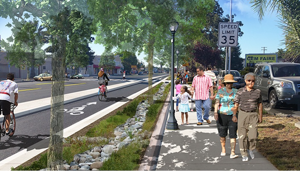
mock-up photo from initial complete streets plan

Other plantings: The initial plan indicated there would be bioswales throughout the project, but I saw only one small one. The plantings in sidewalk buffers are aesthetically pleasing, but not environmentally significant.

Sidewalks: Some sidewalks were upgraded to 6 feet, which is the modern minimum. Ramps were installed at intersections. Driveway crossings are a mix of acceptable and illegal, with cross-slopes in the sidewalk. Other sidewalks were left in their original condition of 4.5 to 5 feet. Falls short.

Sidewalk amenities: There are some trash cans provided by Franklin Blvd Business District. I did not see any other amenities. Weak.

Lighting: Pedestrian-scale lighting, with traditional poles, was installed along the length. The old motor-vehicle scale lighting was left in place. Though I did not visit the street at night, lighting looks to be a great improvement.

Driveways: There are a huge number of driveways in this section, largely due to the traditional development pattern of small business buildings on small parcels, with parking between the street and the building. This is an unfortunate pattern, but not something that can easily be fixed. Most driveways were replaced with a slope in the sidewalk buffer, or more commonly, dip down and back up, which is legal but not ideal. There are several driveways for long abandoned businesses and empty parcels, which should have been closed under the city’s driveway closure policy.

Safe crossings: There are existing signals at Sutterville Road/12th Avenue, 21st Avenue, Atlas Avenue (full pedestrian signal), 26th Avenue (to the west), and Fruitridge Road. At 18th Avenue, there is a new enhanced RRFB (Rectangular Rapid Flashing Beacon). There are RRFBs on a signal mast arm, in addition to at the side, perhaps safer than a standard RRFB, but given driver behavior in Sacramento, not safe. The distance from 26th Avenue to Fruitridge is just over a quarter mile, though there may not be a good location for a crossing in this stretch. The distance from Sutterville/12th Avenue to 18th Avenue is well over a quarter mile, which is an unacceptable distance between safe crossings.

Curb extensions: There was an opportunity to shorten crossing distances and slow drivers by providing curb extensions on the side streets. This was not done.

Bus: SacRT Route 67 runs on Franklin from Broadway to 21st Avenue. There is a pull-out bus stop just south of Sutterville/12th Avenue, which is a timepoint and may be appropriate, though pulling out of traffic, and back in, is poor practice. The other bus stops are in shared bus/bicycle areas, which is probably fine for a low frequency route (30 minutes). It occurs to me that it might be better to run service south on Franklin to Fruitridge Road, to consistently serve the commercial area. The route on Martin Luther King Jr Blvd does serve residential areas, but those are constrained by Hwy 99 to the west and a poor street grid, and the route misses Christian Brothers High School.

Franklin Blvd & Fruitridge Road intersection: This wide flared intersection is hazardous for all users, and nothing was done to improve it. Southbound, Franklin flares from one travel lane to two dedicated left turn lanes (unnecessary and unsafe), one uncontrolled dedicated right hand turn slip lane (highly dangerous for bicyclists and walkers), and one through lane. Everything that was good about the complete streets project gets tossed out the window at this intersection. I realize that it might have only been possible to fix the north leg of the intersection with this project, but no effort was made to do so. Complete failure.
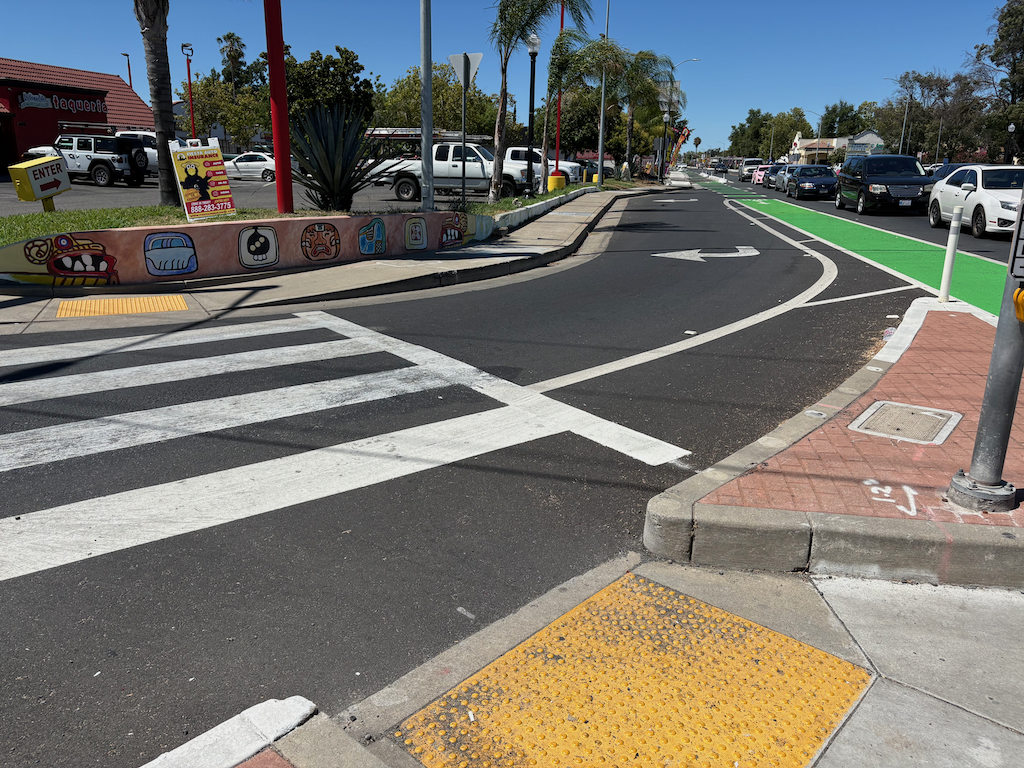
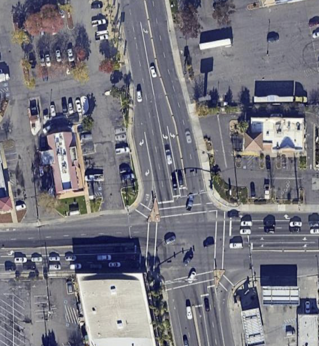
photo of Franklin Blvd southbound at Fruitridge Rd, uncontrolled slip lane
Franklin Blvd southbound at Fruitridge Rd, uncontrolled slip lane
overhead of Franklin Blvd & Fruitridge Road intersection
overhead of Franklin Blvd & Fruitridge Road intersection (only one southbound lane now)

darkness of Caltrans

You might assume from the post title that this is about the climate-killing actions of Caltrans, particularly District 3, which continues to expand highways, with full knowledge of induced demand, and makes life difficult for agencies that would like to improve underpasses and overpasses for walkers and bicyclists. And there is plenty to say about that. But in this case it is literal.

Caltrans is adding capacity to Hwy 50 through Sacramento. In order to do so, they have filled in the space between the two directions of travel. For all the street underpasses, this means that there is now a single bridge rather than two separate ones. There is no longer this gap for daylight to reach the street, so it is much darker. Caltrans could have placed additional lighting in these locations, but they did not. A multimillion dollar project, and they couldn’t afford a few additional lights. They did fix most existing lights, many of which had been out for years, but they did not add any.

This is a big middle finger to people walking, as it is really quite dark under the freeway now.

This really came home to me when I went to the farmers market under the freeway last Sunday. The market is between W and X, and 6th and 8th. It was so dark that it was difficult to see the produce. I had to use my phone flashlight to examine vegetables. The pricing signs were almost impossible to read. One vendor had actually put up lights, and a number of vendors apologized for how dark it was.

Caltrans has essentially killed off this farmers market, because they were too cheap, or too oblivious, or too mean, to install lighting. I won’t be going back. I’m angry, and every person who goes to this market, or pays taxes that Caltrans uses to make things worse, should be angry.

Katie’s Mid-Year Budget Request Sign-On

Katie Valenzuela, Sacramento councilmember for District 4, posted a request for people to sign on to ideas for a mid-year budget adjustment to include several transportation and livability issues, at https://docs.google.com/forms/d/e/1FAIpQLSc2klsRgKrTcY4Ndoh7OWpz9CdwS_-Vb5rZvrrqG9Td75Z1Ig/viewform.


“In the year I’ve been in office, I’ve heard from thousands of people regarding their concerns and ideas about needed improvements in their neighborhoods. When I bring these community concerns to staff, I hear a lot of support and empathy for the issues raised, but it is often followed by a somber realization: there isn’t a sufficient budget to provide these services.

While I understand the limitations of the City budget, I also believe there are basic services any City should provide:

  • Streetlights, particularly in older neighborhoods that lack sufficient lighting to promote safety for all road users.
  • Sidewalk repair, the costs for which we put onto property owners during the 2008 recession. Sidewalks are a public good everyone uses and should be maintained by the City.
  • Public Restrooms to serve everyone in our city, particularly at parks. This should also include porta potties near large encampments.
  • Road and traffic safety improvements, particularly targeting streets and intersections where there are repeated collisions or injuries.
  • Public garbage cans and collection to help mitigate litter.

These needs aren’t unique to District 4, but are issues I’ve also observed citywide. As we approach the midyear and future budgets, I urge you to join me in asking that we consider the quality-of-life improvements the community is asking for and appropriate funds for these purposes.”


These five items are all transportation issues to some degree or another.

Streetlights: Many people will not walk at night when there is insufficient lighting. They feel unsafe. Many intersections are poorly lit for people walking, providing light for drivers but not for people in crosswalks.

Sidewalk repair: The lower the income level of a neighborhood, which is strongly but not complete correlated with people of color, the poorer the sidewalks. This is an ongoing problem in north Sacramento and south Sacramento, but exists other places. When the city claims it has not responsibility for maintaining sidewalks, but does maintain roadways, it is sending a clear message that drivers are more important than walkers. This must change. The first step is not to start fixing sidewalks, but to change city code so that the city is responsible for maintaining sidewalks, not adjacent property owners. There may be situations in which a tree on private property damages a public sidewalk, but most of the damage from trees occurs by city owned trees in the sidewalk buffer area. In fact, the worst sidewalks are often adjacent to city-owned property, where the ordinance requiring property owner repair apparently doesn’t apply. (In the interests of transparency, if one wishes to see truly horrible sidewalks, visit the City of Los Angeles. Makes Sacramento look like a walking paradise.)

broken sidewalk on V Street, Sacramento

Public restrooms: Any person who is walking is likely to be making a slower trip than a driver, and more likely to need to use a restroom during their trip. Walkers are also more likely to chain destinations, and therefore need a restroom during a longer trip, while drivers often make shorter individual trips to single destinations. The city has resisted making public restrooms available, partially in an effort to make unhoused people unwelcome. One new restroom was built in Cesar Chavez Plaza, and some parks have restrooms available for some hours, but many park restrooms remain locked. For example, the one in Fremont Park has been locked up for two years now.

Traffic safety improvements: This one is obvious. What is not obvious is that the city has an unwritten policy that it will only make major street changes with federal, state, and regional grants, not out of the general budget. A few things are done as part of routine maintenance, when a street is repaved and re-striped, but this is a tiny fraction of what is needed. Improvements to high-injury intersections and corridors should be a funded part of the city budget, not dependent upon grants from outside.

Public garbage cans: Again, people walking are likely to generate things that need to be trashed or recycled. For example, walk to your local coffee shop and then continue on your journey, you end up with an empty cup to dispose of. People driving simply throw it on the floor, or out the window in many cases. And if they throw it on the floor, it is likely to be thrown on the ground the next time the vehicle is parked. I know this because this is the pattern for people who commute in from the suburbs and park in the central city. I’ve observed it hundreds of times. It is true that in areas with active business improvement districts, there are more public garbage cans, but that leaves many areas of the city out, which are just as deserving of the service.

The city discriminates against people walking (and bicycling). These budget items would be a first step towards redressing that.

I will say that the greatest need for these improvements is not in District 4, which has often received more attention from the city than any district other than District 1. Sacramento has had and continues to have a serious equity failing, spending more money on repair and improvements in higher income areas.