The SacATC 2026-10-15 meeting will receive a information and comment update on the Franklin Blvd Complete Street Phase 3 project. The project is at the 60% design stage, meaning that plans have been drawn (see the SacATC 2026-10-15 post), but details can still be improved. I have had some time to review the presentation and design diagrams, so have some comments, based on these and on my previous post on the Phase 1 and 2 project which is complete. The Phase 1 and 2 project ended at Fruitridge Road. There have been various city and county projects on other segments of Franklin.
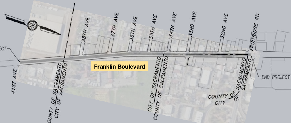
The extent of this Phase 3 project is Fruitridge Road to the county line just beyond 38th Avenue, shown below. The southern part of the project (to the left) is in the city, and the northern part (to the right) is shared city and county, but the city is taking responsibility for the entire project.
I note four areas of concern.
One: RRFB (Rectangular Rapid Flashing Beacon) at 33rd Street. RRFBs have a very low rate of compliance in the City of Sacramento, in part because we have among the worst drivers in the state. The installation here includes two beacons, one on the post, and another on an overhead mast arm. This format may slightly increase compliance, but the city has not demonstrated that it increases compliance enough to be safe for people crossing here. The city knows that existing RRFB locations are not safe, but continues to specify them, against the advice of transportation advocates. Either there should be a pedestrian hybrid signal at this location, or it should not be highlighted as a safe crossing, because it is not. Of course every intersection has a crosswalk, whether marked or unmarked, but the presence of a marked crosswalk with RRFB signal implies a level of safety that does not exist.
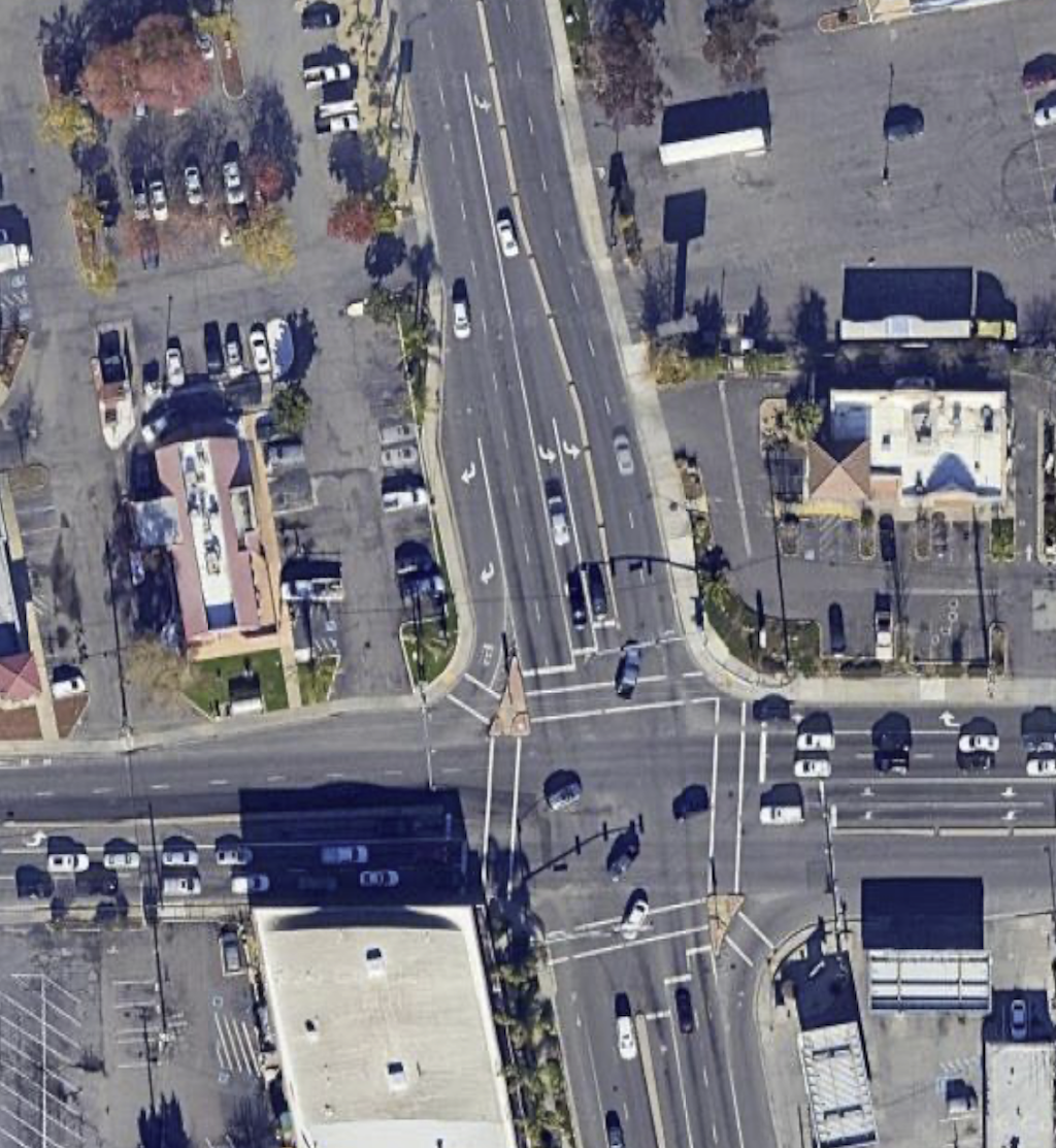
Two: Flared intersection at Fruitridge. The flared intersection of Franklin Blvd southbound at Fruitridge, which I criticized in my previous post as being unsafe for all users, is proposed to be duplicated south of the intersection in this Phase 3. The Google map overview is below. North of Fruitridge, the configuration has changed somewhat. South of Fruitridge, it is as shown, with two lanes southbound, two lanes northbound, a dedicated left turn lane, and a dedicated right turn lane which is a free-right with no traffic control whatsoever.
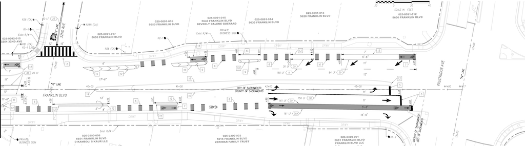
The design diagram for Franklin at Fruitridge is below. It shows some improvement, with only one lane northbound, but is otherwise the same. Two lanes southbound, requiring a merge that could be avoided by making it one lane, as it is on the approach from the north, and one of the lanes is 12 feet, unnecessarily wide. The southbound bike lane is 5.5 feet, too narrow, and does eventually have painted buffer ‘protection’. The dangerous dedicated right turn lane is retained, though it does add a stop sign, which would be widely ignored, and encourages the same driver behavior to look left and ignore anyone in the crosswalk. The lane is 13.5 feet wide, which is ridiculous. The marked northbound bike lane is 5.5 feet, too narrow, between two motor vehicle travel lanes, with no protection whatsoever.
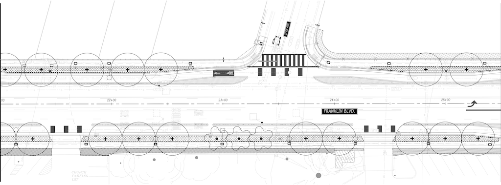
Three: Trees and sidewalk buffers (planting strips). Though sidewalk buffers and trees are being added along about half of the segment, both are missing from the remainder. This is better than it was, but far from the tree canopy/shade that the public has requested. Though I could not find a diagram where the width of the sidewalk buffer was specified, I estimate that they are mostly five feet, but narrower in a few locations. Healthy trees require eight feet or more, so the trees along this section will always be less healthy than they could be. Tree information starts on page 61 of the design diagrams document, with Landscape Planting Legend (LP002), and includes six street sections. A total of 50 trees are indicated, though it is doubtful, given past projects, that all of these will be planted. The diagram below shows the 37th Street section, with more trees than any other.
Four: Wide concrete bikeway medians. There are a number of locations with very wide concrete medians to separate the bikeway from travel lanes. I’m all in favor of concrete medians, which provide real protection rather than the visual protection of vertical delineators. But a narrow concrete median is just as effective in providing protection as a wide median. In many cases, these medians seem overly wide, as though to simply take up excess space. Though the stamped concrete specified for many of them is slightly better aesthetically than plain concrete, it is still an unnecessary expanse of heat generating and expensive infrastructure. If possible, this width should be reallocated to sidewalks and sidewalk buffers.